Dixfield (CDP), Maine

Last updated

Dixfield, Maine
CDP
Dixfield ME 1.JPG
USA Maine location map.svg
Red pog.svg
Dixfield, Maine
Location within the state of Maine
Coordinates: 44°32′13″N70°27′11″W / 44.53694°N 70.45306°W / 44.53694; -70.45306
CountryUnited States
State Maine
County Oxford
Area
[1]
  Total1.90 sq mi (4.91 km2)
  Land1.79 sq mi (4.64 km2)
  Water0.10 sq mi (0.27 km2)
Elevation
436 ft (133 m)
Population
 (2020)
  Total1,323
  Density738.69/sq mi (285.21/km2)
Time zone UTC-5 (Eastern (EST))
  Summer (DST) UTC-4 (EDT)
ZIP code
04224
Area code 207
FIPS code 23-17705
GNIS feature ID0565133

Dixfield is a census-designated place (CDP) in the town of Dixfield in Oxford County, Maine, United States. The population was 1,323 at the 2020 census. [2]

Contents

Geography

Dixfield is located at 44°32′13″N70°27′10″W / 44.53694°N 70.45278°W / 44.53694; -70.45278 (44.537056, −70.453032). [3]

According to the United States Census Bureau, the CDP has a total area of 0.8 square miles (2.2 km2), all land.

Demographics

Historical population
CensusPop.Note
2020 1,323
U.S. Decennial Census [4]

As of the census [5] of 2020, there were 1,323 people, 581 households, and 606 families residing in the CDP. [6] The population density was 1,353.2 inhabitants per square mile (522.5/km2). There were 655 housing units at an average density of 344.73 per square mile (133.10/km2). The racial makeup of the CDP was 98.24% White, 0.44% Native American, 0.53% Asian, 0.09% from other races, and 0.70% from two or more races. Hispanic or Latino of any race were 0.26% of the population.

There were 581 households, out of which 29.2% had children under the age of 18 living with them, 50.8% were married couples living together, 10.0% had a female householder with no husband present, and 34.3% were non-families. [7] 29.8% of all households were made up of individuals, and 15.1% had someone living alone who was 65 years of age or older. The average household size was 2.32 and the average family size was 2.84.

In the CDP, the population was spread out, with 15.1% under the age of 18, 63.0% from 18 to 65, and 16.1% who were 65 years of age or older. [8] The median age was 41 years. For every 100 females, there were 85.8 males. For every 100 females age 18 and over, there were 87.3 males.

The median income for a household in the CDP was $35,676, and the median income for a family was $50,208. [9] Males had a median income of $36,250 versus $25,208 for females. The per capita income for the CDP was $16,304. About 5.1% of families and 27.9% of the population were below the poverty line, including 53.6% of those under age 18 and 25.0% of those age 65 or over. [10]

Dixfield town hall and post office Dixfield ME 2.JPG
Dixfield town hall and post office

Related Research Articles

<span class="mw-page-title-main">Three Points, Arizona</span> CDP in Arizona, United States

Three Points is a census-designated place (CDP) in Pima County, Arizona, United States. The population was 5,581 at the 2010 census.

<span class="mw-page-title-main">Pelican Bay, Florida</span> Census-designated place in Florida

Pelican Bay is a census-designated place (CDP) in Collier County, Florida, United States. The population was 6,346 at the 2010 census. It is part of the Naples–Marco Island Metropolitan Statistical Area.

<span class="mw-page-title-main">Homestead Base, Florida</span> Census-designated place in Florida, United States

Homestead Base is a census-designated place (CDP) in Miami-Dade County, Florida, United States. The population was 999 at the 2020 census. The CDP comprises the extent of Homestead Air Reserve Base plus some surrounding land.

<span class="mw-page-title-main">Princeton, Florida</span> Census-designated place in Florida, United States

Princeton is a census-designated place (CDP) and unincorporated community in Miami-Dade County, Florida, United States. The population was 39,208 at the 2020 census, up from 22,038 at the 2010 census.

<span class="mw-page-title-main">Lake of the Woods, Illinois</span> Census-designated place in Illinois, United States

Lake of the Woods is a census-designated place (CDP) in Champaign County, Illinois, United States. The population was 2403 at the 2020 census. Lake of the Woods is in Mahomet Township and mostly surrounded by the northeast part of the village of Mahomet.

<span class="mw-page-title-main">Channel Lake, Illinois</span> Census-designated place in Illinois, United States

Channel Lake is an unincorporated community and census-designated place (CDP) in Antioch Township, Lake County, Illinois, United States. Per the 2020 census, the population was 1,581.

Rock Island Arsenal is a census-designated place (CDP) in Rock Island County, Illinois, United States. The population was 149 at the 2010 census. The island contains the Rock Island National Cemetery.

<span class="mw-page-title-main">Forestdale, Massachusetts</span> Census-designated place in Massachusetts, United States

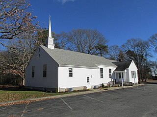
Forestdale is a village and census-designated place (CDP) within the town of Sandwich in Barnstable County, Massachusetts, United States. The population of Forestdale was 4,099 at the 2010 census. It is the most populous of the three CDPs in Sandwich. The ZIP code of Forestdale is 02644.

<span class="mw-page-title-main">Acushnet Center, Massachusetts</span> Census-designated place in Massachusetts, United States

Acushnet Center is a census-designated place (CDP) in the town of Acushnet in Bristol County, Massachusetts, United States. The population was 3,073 at the 2010 census.

<span class="mw-page-title-main">North Pembroke, Massachusetts</span> Census-designated place in Massachusetts, United States

North Pembroke is a census-designated place (CDP) in the town of Pembroke in Plymouth County, Massachusetts, United States. The population was 3,292 at the 2010 census.

<span class="mw-page-title-main">Onset, Massachusetts</span> Census-designated place in Massachusetts, United States

Onset is a census-designated place (CDP) in the town of Wareham, Massachusetts, United States. The population was 1,573 at the 2010 census.

<span class="mw-page-title-main">West Swanzey, New Hampshire</span> Census-designated place in New Hampshire, United States

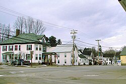
West Swanzey is a census-designated place (CDP) in the town of Swanzey within Cheshire County, New Hampshire, United States. The population was 1,281 at the 2020 census. It is the largest village in the town of Swanzey.
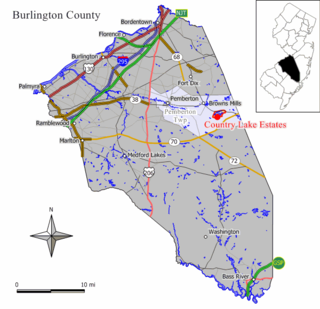
<span class="mw-page-title-main">Springdale, New Jersey</span> Census-designated place in New Jersey, United States

Springdale is an unincorporated community and census-designated place (CDP) located within Cherry Hill Township, in Camden County, New Jersey, United States. As of the 2010 United States Census, the section population was 14,518.

<span class="mw-page-title-main">Noyack, New York</span> Census-designated place in New York, United States

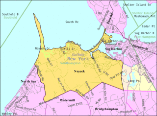
Noyack is a hamlet and census-designated place (CDP) in Suffolk County, New York, United States. The CDP population was 4,325 at the 2020 census.
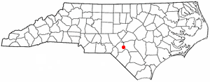
Middle Valley is a census-designated place (CDP) in Hamilton County, Tennessee, United States. The population was 11,695 at the 2020 census. It is part of the Chattanooga, TN–GA Metropolitan Statistical Area.

<span class="mw-page-title-main">Leisuretowne, New Jersey</span> Census-designated place in New Jersey, United States

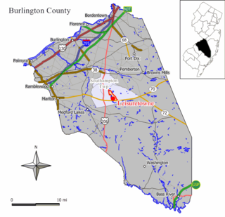
Leisuretowne is an unincorporated community and census-designated place (CDP) located within Southampton Township, in Burlington County, New Jersey, United States. As of the 2010 United States Census, the CDP's population was 3,582.

<span class="mw-page-title-main">Dooms, Virginia</span> CDP in Virginia, United States

Dooms is a census-designated place (CDP) in Augusta County, Virginia, United States. The population was 1,327 at the 2010 census. It is part of the Staunton–Waynesboro Micropolitan Statistical Area.

<span class="mw-page-title-main">Kittery (CDP), Maine</span> Census-designated place in Maine, United States

Kittery is a census-designated place (CDP) consisting of the main village in the town of Kittery in York County, Maine, United States. The village is also known as Kittery Foreside. The population of the CDP was 4,562 at the 2010 census. It is part of the Portland–South Portland–Biddeford, Maine Metropolitan Statistical Area.

<span class="mw-page-title-main">Bourne (CDP), Massachusetts</span> Census-designated place in Massachusetts, United States

The village of Bourne is a census-designated place (CDP) in the town of Bourne in Barnstable County, Massachusetts, United States. The population was 1,418 at the 2010 census, out of 19,754 in the town of Bourne as a whole.

Langleyville is an unincorporated census-designated place in Christian County, Illinois, United States. As of the 2020 census, it had a population of 391.

References

  1. "2020 U.S. Gazetteer Files". United States Census Bureau. Retrieved April 8, 2022.
  2. "Explore Census Data".
  3. "US Gazetteer files: 2010, 2000, and 1990". United States Census Bureau. February 12, 2011. Retrieved April 23, 2011.
  4. "Census of Population and Housing". Census.gov. Retrieved June 4, 2016.
  5. "U.S. Census website". United States Census Bureau . Retrieved 2008-01-31.
  6. "Explore Census Data".
  7. "Explore Census Data".
  8. "Explore Census Data".
  9. "Explore Census Data".
  10. "Explore Census Data".