Penobscot County is a county in the U.S. state of Maine, named for the Penobscot people in Wabanakik. As of the 2020 census, the population was 152,199, making it the third-most-populous county in Maine. Its county seat is Bangor. The county was established on February 15, 1816, from part of Hancock County when the area was still part of Massachusetts. Penobscot County is home to the University of Maine.

Oxford County is a county in the state of Maine, United States. As of the 2020 Census, the county had a population of 57,777. Its county seat is the town of Paris. The county was formed on March 4, 1805, by the Massachusetts General Court in the Maine District from northerly portions of York and Cumberland counties. It borders the Canadian province of Quebec. Part of Oxford County is included in the Lewiston-Auburn, Maine metropolitan New England City and Town Area while a different part of Oxford County is included in the Portland-South Portland-Biddeford, Maine metropolitan New England City and Town Area.

Castle Hill is a town in Aroostook County, Maine, United States. The population was 373 people at the 2020 census.

St. John Plantation is a plantation in Aroostook County, Maine, United States, on the banks of the Saint John River. The population was 263 at the 2020 census.

Winterville Plantation is a plantation in Aroostook County, Maine, United States. The population was 194 at the 2020 census.

Carthage is a town in Franklin County, Maine, United States. The population was 509 at the 2020 census.

Dallas Plantation is a plantation in Franklin County, Maine, United States. The population was 304 at the 2020 census.

Litchfield is a town in Kennebec County, Maine, United States. The population was 3,586 at the 2020 census. Litchfield is included in the Augusta, Maine micropolitan and included in the Lewiston-Auburn, Maine metropolitan New England city and town area. Litchfield is included Wales, Maine micropolitan

Gilead is a town in Oxford County, Maine, United States. Upon incorporation in 1804, it was named for the large quantity of Balm of Gilead trees in the town center. The population was 195 at the 2020 census.

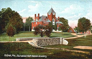
Hebron is a town in Oxford County, Maine, United States. Hebron is included in the Lewiston-Auburn, Maine metropolitan New England city and town area. The town's history has always been interconnected with Hebron Academy, a co-ed college preparatory boarding school which is located in the town's heart. The population was 1,223 at the 2020 census. There is an elementary school, Hebron Station School, located on Station Road.

Magalloway is a township in Oxford County, Maine, United States. It has been part of North Oxford unorganized territory since it de-organized as a plantation in 2021. The population was 45 at the 2020 census. Part of the Umbagog National Wildlife Refuge is located at its southwestern corner.

Peru is a town in Oxford County, Maine, United States. Peru is included in the Lewiston-Auburn, Maine metropolitan New England city and town area. The population was 1,488 at the 2020 census.
Woodstock is a town in Oxford County, Maine, United States. Woodstock is included in the Lewiston-Auburn, Maine metropolitan New England city and town area. The population was 1,352 at the 2020 census. The village of Bryant Pond, on State Route 26 in the northern part of Woodstock, is the town's urban center and largest settlement.
Carroll Plantation is a plantation in Penobscot County, Maine, United States. The plantation was named for Daniel Carroll, a signatory of the United States Constitution. It is located along Maine State Route 6 near its intersection with State Route 170. The population was 138 at the 2020 census. It is part of the Bangor Metropolitan Statistical Area.
Drew is a township in Penobscot County, Maine, United States. The population was 26 at the 2020 census. It is part of the Bangor Metropolitan Statistical Area. The Surety of Sinners Orthodox Mission, a Russian Orthodox church, is located in Drew. A former plantation, Drew completed the de-organization process in 2023 to become part of Maine's unorganized territory.
Webster Plantation is a plantation in Penobscot County, Maine, United States. The population was 68 at the 2020 census.
West Forks is a plantation in Somerset County, Maine, United States. The population was 58 at the 2020 census.
Codyville is a township in Washington County, Maine, United States, that is part of the unorganized territory of North Washington. The population was 13 at the 2020 census. Codyville was formerly a plantation, but it disorganized in 2019.
Milton is an unorganized territory (township) in Oxford County, Maine, United States. The population was 150 at the 2020 census. The township was formerly a plantation that surrendered its organization in 1939.

Oxford is a town in Oxford County, Maine, United States. Oxford is included in the Lewiston-Auburn, Maine metropolitan New England city and town area. The population was 4,229 at the 2020 census. Oxford is home to the Oxford Plains Speedway, Kamp Kohut, the annual Oxford County Fair, and Oxford Casino. The town includes the village of Welchville.


