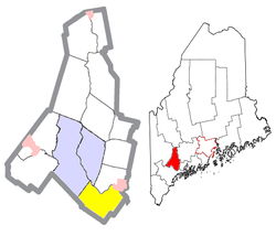
Durham, Maine | |
---|---|
Coordinates: 43°58′21″N70°7′23″W / 43.97250°N 70.12306°W | |
Country | United States |
State | Maine |
County | Androscoggin |
Incorporation | February 17, 1789 |
Villages | Crossman Corner Plummer Mill Shiloh South Durham South West Bend West Durham |
Area | |
• Total | 39.04 sq mi (101.11 km2) |
• Land | 38.28 sq mi (99.14 km2) |
• Water | 0.76 sq mi (1.97 km2) |
Elevation | 167 ft (51 m) |
Population (2020) | |
• Total | 4,173 |
• Density | 109/sq mi (42.1/km2) |
Time zone | UTC-5 (Eastern (EST)) |
• Summer (DST) | UTC-4 (EDT) |
ZIP code | 04222 |
Area code | 207 |
FIPS code | 23-19105 |
GNIS feature ID | 0582448 |
Website | www |
Durham is a town in Androscoggin County, Maine, United States. The population was 4,173 at the 2020 census. [2] It is included in both the Lewiston-Auburn, Maine Metropolitan Statistical Area and the Lewiston-Auburn, Maine Metropolitan New England City and Town Area.
Durham was named after County Durham, England, the ancestral home of the town's first settler. [3] It was previously known as Royallsborough, named after Isaac Royall Jr. [4]
According to the United States Census Bureau, the town has a total area of 39.04 square miles (101.11 km2), of which 38.28 square miles (99.14 km2) is land and 0.76 square miles (1.97 km2) is water. [1]
Durham is bordered by Auburn, Lewiston, Lisbon, Topsham, Brunswick, Freeport, Pownal and New Gloucester.
Durham is considered a "gateway" town because it connects two major Maine communities, the Greater Portland Area with the Lewiston–Auburn Area.
According to the Köppen Climate Classification system, Durham has a warm-summer humid continental climate, abbreviated "Dfb" on climate maps. The hottest temperature recorded in Durham was 97 °F (36.1 °C) on July 18, 1999, September 4, 1999, August 10, 2001, and June 21, 2024, while the coldest temperature recorded was −27 °F (−32.8 °C) on January 16, 2009. [5]
Climate data for Durham, Maine, 1991–2020 normals, extremes 1994–present | |||||||||||||
---|---|---|---|---|---|---|---|---|---|---|---|---|---|
Month | Jan | Feb | Mar | Apr | May | Jun | Jul | Aug | Sep | Oct | Nov | Dec | Year |
Record high °F (°C) | 62 (17) | 64 (18) | 86 (30) | 91 (33) | 95 (35) | 97 (36) | 97 (36) | 97 (36) | 97 (36) | 85 (29) | 77 (25) | 68 (20) | 97 (36) |
Mean maximum °F (°C) | 50.9 (10.5) | 51.2 (10.7) | 60.7 (15.9) | 74.9 (23.8) | 87.4 (30.8) | 88.2 (31.2) | 89.8 (32.1) | 87.1 (30.6) | 84.1 (28.9) | 73.4 (23.0) | 63.8 (17.7) | 54.1 (12.3) | 91.9 (33.3) |
Mean daily maximum °F (°C) | 29.3 (−1.5) | 32.9 (0.5) | 41.4 (5.2) | 54.1 (12.3) | 65.4 (18.6) | 73.6 (23.1) | 79.0 (26.1) | 77.5 (25.3) | 70.4 (21.3) | 58.1 (14.5) | 45.9 (7.7) | 35.2 (1.8) | 55.2 (12.9) |
Daily mean °F (°C) | 18.4 (−7.6) | 20.9 (−6.2) | 30.2 (−1.0) | 41.8 (5.4) | 52.6 (11.4) | 61.9 (16.6) | 67.6 (19.8) | 65.9 (18.8) | 58.5 (14.7) | 46.9 (8.3) | 36.2 (2.3) | 25.6 (−3.6) | 43.9 (6.6) |
Mean daily minimum °F (°C) | 7.5 (−13.6) | 8.9 (−12.8) | 19.0 (−7.2) | 29.6 (−1.3) | 39.7 (4.3) | 50.3 (10.2) | 56.2 (13.4) | 54.3 (12.4) | 46.5 (8.1) | 35.7 (2.1) | 26.5 (−3.1) | 16.0 (−8.9) | 32.5 (0.3) |
Mean minimum °F (°C) | −11.1 (−23.9) | −8.5 (−22.5) | −1.1 (−18.4) | 21.3 (−5.9) | 29.4 (−1.4) | 41.1 (5.1) | 48.9 (9.4) | 45.5 (7.5) | 33.8 (1.0) | 25.6 (−3.6) | 13.6 (−10.2) | −0.5 (−18.1) | −15.4 (−26.3) |
Record low °F (°C) | −27 (−33) | −23 (−31) | −15 (−26) | 12 (−11) | 24 (−4) | 31 (−1) | 44 (7) | 37 (3) | 27 (−3) | 18 (−8) | 3 (−16) | −23 (−31) | −27 (−33) |
Average precipitation inches (mm) | 3.61 (92) | 3.35 (85) | 4.06 (103) | 4.53 (115) | 3.59 (91) | 4.64 (118) | 3.75 (95) | 3.65 (93) | 4.15 (105) | 5.37 (136) | 4.49 (114) | 4.54 (115) | 49.73 (1,262) |
Average snowfall inches (cm) | 20.8 (53) | 19.4 (49) | 13.8 (35) | 3.7 (9.4) | 0.0 (0.0) | 0.0 (0.0) | 0.0 (0.0) | 0.0 (0.0) | 0.0 (0.0) | 0.3 (0.76) | 3.3 (8.4) | 16.2 (41) | 77.5 (196.56) |
Average extreme snow depth inches (cm) | 17.2 (44) | 20.0 (51) | 17.7 (45) | 7.5 (19) | 0.0 (0.0) | 0.0 (0.0) | 0.0 (0.0) | 0.0 (0.0) | 0.0 (0.0) | 0.3 (0.76) | 2.3 (5.8) | 11.7 (30) | 23.3 (59) |
Average precipitation days (≥ 0.01 in) | 11.4 | 10.1 | 10.7 | 11.7 | 13.2 | 13.7 | 12.0 | 10.9 | 9.7 | 12.2 | 11.4 | 12.6 | 139.6 |
Average snowy days (≥ 0.1 in) | 8.7 | 7.6 | 5.3 | 1.5 | 0.0 | 0.0 | 0.0 | 0.0 | 0.0 | 0.2 | 1.9 | 6.7 | 31.9 |
Source 1: NOAA [6] | |||||||||||||
Source 2: National Weather Service (mean maxima/minima, snow depth 2006–2020) [5] |
Census | Pop. | Note | %± |
---|---|---|---|
1790 | 724 | — | |
1800 | 1,242 | 71.5% | |
1810 | 1,772 | 42.7% | |
1820 | 1,562 | −11.9% | |
1830 | 1,731 | 10.8% | |
1840 | 1,836 | 6.1% | |
1850 | 1,886 | 2.7% | |
1860 | 1,623 | −13.9% | |
1870 | 1,350 | −16.8% | |
1880 | 1,253 | −7.2% | |
1890 | 1,111 | −11.3% | |
1900 | 1,230 | 10.7% | |
1910 | 1,625 | 32.1% | |
1920 | 1,144 | −29.6% | |
1930 | 806 | −29.5% | |
1940 | 784 | −2.7% | |
1950 | 1,050 | 33.9% | |
1960 | 1,086 | 3.4% | |
1970 | 1,264 | 16.4% | |
1980 | 2,074 | 64.1% | |
1990 | 2,842 | 37.0% | |
2000 | 3,381 | 19.0% | |
2010 | 3,848 | 13.8% | |
2020 | 4,173 | 8.4% | |
U.S. Decennial Census [7] |
As of the census [8] of 2010, there were 3,848 people, 1,496 households, and 1,143 families living in the town. The population density was 100.5 inhabitants per square mile (38.8/km2). There were 1,548 housing units at an average density of 40.4 per square mile (15.6/km2). The racial makeup of the town was 97.8% White, 0.3% African American, 0.1% Native American, 0.5% Asian, 0.2% from other races, and 1.0% from two or more races. Hispanic or Latino of any race were 0.8% of the population.
There were 1,496 households, of which 33.5% had children under the age of 18 living with them, 63.6% were married couples living together, 7.5% had a female householder with no husband present, 5.3% had a male householder with no wife present, and 23.6% were non-families. 16.6% of all households were made up of individuals, and 4% had someone living alone who was 65 years of age or older. The average household size was 2.57 and the average family size was 2.85.
The median age in the town was 41.2 years. 22.3% of residents were under the age of 18; 5.5% were between the ages of 18 and 24; 29.1% were from 25 to 44; 33.8% were from 45 to 64; and 9.3% were 65 years of age or older. The gender makeup of the town was 50.6% male and 49.4% female.
As of the census [9] of 2000, there were 3,381 people, 1,226 households, and 980 families living in the town. The population density was 88.7 inhabitants per square mile (34.2/km2). There were 1,257 housing units at an average density of 33.0 per square mile (12.7/km2). The racial makeup of the town was 98.96% White, 0.12% African American, 0.15% Native American, 0.27% Asian, 0.09% from other races, and 0.41% from two or more races. Hispanic or Latino of any race were 0.65% of the population.
There were 1,226 households, out of which 38.9% had children under the age of 18 living with them, 70.6% were married couples living together, 5.9% had a female householder with no husband present, and 20.0% were non-families. 12.4% of all households were made up of individuals, and 3.0% had someone living alone who was 65 years of age or older. The average household size was 2.75 and the average family size was 3.02.
In the town, the population was spread out, with 26.9% under the age of 18, 5.2% from 18 to 24, 35.5% from 25 to 44, 25.5% from 45 to 64, and 6.8% who were 65 years of age or older. The median age was 37 years. For every 100 females, there were 99.5 males. For every 100 females age 18 and over, there were 99.2 males.
The median income for a household in the town was $53,846, and the median income for a family was $55,028. Males had a median income of $35,174 versus $28,342 for females. The per capita income for the town was $20,883. About 5.9% of families and 6.6% of the population were below the poverty line, including 8.2% of those under age 18 and 9.8% of those age 65 or over.
Voter registration
Voter Registration and Party Enrollment as of January 2015 [10] | |||||
---|---|---|---|---|---|
Party | Total Voters | Percentage | |||
Unenrolled | 1,282 | 40.3% | |||
Republican | 946 | 29.7% | |||
Democratic | 772 | 24.2% | |||
Green Independent | 179 | 5.6% | |||
Total | 3,179 | 100% |
Durham is in Maine's 2nd congressional district, Maine Senate District 22, [11] and Maine House of Representatives District 46. [12]
The privately owned Margerison Airport is located between Hallowell Road and Royalsborough Road, just north of Rabbit Road. Its FAA identifier is ME75, and it was activated in 1979. It has two unpaved runways—headings 9/27 and 15/33. Its area control center is Boston Center, while its flight service station is Bangor. [14]
Androscoggin County is a county in the U.S. state of Maine. As of the 2020 census, the county's population was 111,139. Its county seat is Auburn and its most populous city is Lewiston.
Auburn is a city in south-central Maine, within the United States. The city serves as the county seat of Androscoggin County. The population was 24,061 at the 2020 census. Auburn and its sister city Lewiston are known locally as the Twin Cities or Lewiston–Auburn (L–A).
Greene is a town in Androscoggin County, Maine, United States. The population was 4,376 at the 2020 census. It is included in both the Lewiston-Auburn, Maine metropolitan statistical area and the Lewiston-Auburn, Maine Metropolitan New England city and town area. The central village in the town comprises the Greene census-designated place.
Leeds is a town in Androscoggin County, Maine, United States. The population was 2,262 at the 2020 census. It is included in both the Lewiston-Auburn, Maine Metropolitan Statistical Area and the Lewiston-Auburn, Maine Metropolitan New England City and Town Area.
Lisbon is a town in Androscoggin County, Maine, United States. The population was 9,711 at the 2020 census. It is included in both the Lewiston-Auburn, Maine metropolitan statistical area and the Lewiston–Auburn, Maine Metropolitan New England city and town area. The town of Lisbon includes the villages of Lisbon and Lisbon Falls.
Minot is a town in Androscoggin County, Maine, United States. The population was 2,766 at the 2020 census. The town includes the villages of West Minot and Minot Center. It is part of both the Lewiston-Auburn, Maine metropolitan statistical area and the Lewiston-Auburn, Maine metropolitan New England city and town area.
Sabattus is a town in Androscoggin County, Maine, United States. The population was 5,044 at the 2020 census. It is included in both the Lewiston-Auburn, Maine Metropolitan Statistical Area and the Lewiston-Auburn, Maine Metropolitan New England City and Town Area. The town was formerly known as "Webster", and changed its name to "Sabattus" in 1971, in honor of a former Anasagunticook Indian chief. The village of Sabattus is in the northwestern corner of the town, at the outlet of Sabattus Pond.
Wales is a town in Androscoggin County, Maine, United States. The population was 1,608 at the 2020 census. It is included in both the Lewiston-Auburn, Maine Metropolitan Statistical Area and the Lewiston-Auburn, Maine Metropolitan New England City and Town Area.
New Gloucester is a town in Cumberland County, Maine, United States. New Gloucester is included in the Lewiston-Auburn, Maine metropolitan New England city and town area. It is home to the Sabbathday Lake Shaker Village, the last active Shaker village in the U.S. The town's population was 5,676 at the 2020 census.
Pownal is a town in Cumberland County, Maine, United States. Pownal was included in the Lewiston-Auburn, Maine metropolitan New England city and town area. The population was 1,566 at the 2020 census. It is part of the Portland–South Portland–Biddeford, Maine Metropolitan Statistical Area. Pownal is home to Bradbury Mountain State Park.
Manchester is a town in Kennebec County, Maine, United States, located at 44.33°N 69.87°W. The population was 2,456 at the 2020 census. The southern part of the town bordering Cobbosseecontee Lake is a popular recreation spot in central Maine, and part of the Winthrop Lakes Region. Manchester is included in the Augusta, Maine micropolitan and included in the Lewiston-Auburn, Maine metropolitan New England City and Town Area.
Wayne is a town in Kennebec County, Maine, United States. Wayne is included in the Lewiston-Auburn, Maine metropolitan New England city and town area. The population was 1,129 at the 2020 census. The town was named after Revolutionary War General Anthony Wayne. During the summer, Wayne is home to Camp Androscoggin. A popular recreation spot in central Maine, Wayne is part of the Winthrop Lakes Region. The town is included in the Augusta, Maine micropolitan New England City and Town Area. and included in the Lewiston-Auburn, Maine metropolitan New England city and town area.
Byron is a town in Oxford County, Maine, United States. The population was 103 at the 2020 census. Home to Coos Canyon on the Swift River, Byron includes the village of Houghton.
Hartford is a town in Oxford County, Maine, United States. Hartford is included in the Lewiston-Auburn, Maine metropolitan New England City and Town Area. The population was 1,203 at the 2020 census.
Peru is a town in Oxford County, Maine, United States. Peru is included in the Lewiston-Auburn, Maine metropolitan New England city and town area. The population was 1,488 at the 2020 census.
Sumner is a town in Oxford County, Maine, United States. Sumner is included in the Lewiston-Auburn, Maine metropolitan New England city and town area. The population was 994 at the 2020 census. The town includes the villages of West Sumner and East Sumner.
Woodstock is a town in Oxford County, Maine, United States. Woodstock is included in the Lewiston-Auburn, Maine metropolitan New England city and town area. The population was 1,352 at the 2020 census. The village of Bryant Pond, on State Route 26 in the northern part of Woodstock, is the town's urban center and largest settlement.
Bowdoin is a town in Sagadahoc County, Maine, United States. Bowdoin is included in the Lewiston-Auburn, Maine metropolitan New England city and town area. The population was 3,136 at the 2020 census. Bowdoin is 31 land miles north of Portland, and 21 land miles south of Augusta.
Livermore Falls is a town in Androscoggin County, Maine, United States. The population was 3,060 at the 2020 census. It is included in both the Lewiston-Auburn, Maine Metropolitan Statistical Area and the Lewiston-Auburn, Maine Metropolitan New England City and Town Area. High school students in Livermore Falls attend Spruce Mountain High School.
Mechanic Falls is a town in Androscoggin County, Maine, United States. The population was 3,107 at the 2020 census. It is included in both the Lewiston-Auburn, Maine metropolitan statistical area and the Lewiston-Auburn, Maine metropolitan New England city and town area.
{{cite web}}
: CS1 maint: archived copy as title (link)