
Hannibal Hamlin was the 15th vice president of the United States, serving from 1861 to 1865, during President Abraham Lincoln's first term. He was the first Republican vice president.
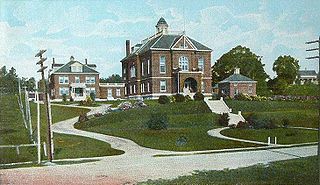
Paris is a town in and the county seat of Oxford County, Maine, United States. Paris is included in the Lewiston-Auburn, Maine metropolitan New England City and town area. The population was 5,179 at the 2020 census. The census-designated place of South Paris is located within the town. Because the U.S. Post Office refers to the entire town as South Paris, the town as a whole is commonly referred to as South Paris. The main exception is the area known as Paris Hill, which is a scenic historic district popular with tourists. On May 30, 2019, the town declared itself to be a second amendment sanctuary.

South Paris is a census-designated place (CDP) located within the town of Paris in Oxford County, Maine, United States. South Paris is included in the Lewiston-Auburn, Maine metropolitan New England city and town area.The population was 2,237 at the 2000 census. While the CDP refers only to the densely settled area in the southern part of the town of Paris, the entire town, outside of Paris Hill, is located within the South Paris ZIP code, resulting in many residents referring to the entire town as South Paris.

Wakefield is a village in the town of South Kingstown, Rhode Island, United States, and the commercial center of South Kingstown. Together with the village of Peace Dale, it is treated by the U.S. Census as a component of the census-designated place identified as Wakefield-Peacedale. West Kingston, another South Kingstown village, was the traditional county seat of Washington County. Since 1991, the Washington County Courthouse has been in Wakefield. The Sheriff's Office which handles corrections is also in Wakefield.

Samuel Freeman Hersey was a politician and "lumber baron" from the U.S. state of Maine. He served in the Maine State Senate and as a United States Congressman from the district which included his hometown of Bangor.

Charles Stetson was a United States representative from Maine, and the eldest member of a powerful Bangor political family. He was born in New Ipswich, New Hampshire, on November 2, 1801, but moved with his parents to Hampden, Maine, in 1802. His father Simeon Stetson kept a store and a sawmill, and built vessels for the West India Trade. His uncle Amasa Stetson was proprietor of the nearby town of Stetson, Maine, where Simeon had briefly settled before moving to Hampden.
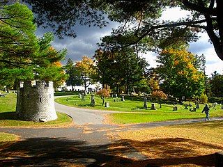
Mount Hope Cemetery in Bangor, Maine, is the second oldest garden cemetery in the United States. It was designed by architect Charles G. Bryant in 1834 and built by the Bangor Horticultural Society soon after, the same year that Bangor was incorporated as a city. The cemetery was modeled after Mount Auburn Cemetery (1831) in Boston, Massachusetts. Bangor was at that time a frontier boom-town, and much of its architecture and landscaping was modeled after that of Boston. The site has been listed on the National Register of Historic Places.
Westport Town Hall is the current town hall of Westport, Maine. It is located on Main Road in a former Congregational church built in 1794. The building, used as the town hall since 1885, was listed on the National Register of Historic Places in 2002 as Union Meeting House, (Former) [sic].

The Barre Downtown Historic District encompasses the historic commercial and civic heart of the city of Barre, Vermont. Extending along Main Street from City Park to Depot Square, this area was developed quite rapidly in the 1880s and 1890s, when the area experienced rapid growth due to the expansion of the nearby granite quarries. It was listed on the National Register of Historic Places in 1979.

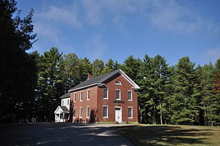
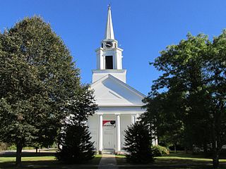
The Haverhill Corner Historic District encompasses the early civic center of Haverhill, New Hampshire, United States. The district is focused on the junction of New Hampshire Route 10 and Court Street, which was historically a major through route. Court Street is flanked at the junction by a pair of large grassy common areas which are bounded by School Street and Route 10. Buildings, predominantly Federal in character and built in the late 18th and early 19th centuries, are arrayed around these commons, and historic buildings line Route 10 and Court Street for a short distance away from the commons. Prominent buildings in the district include the 1827 Federal-style First Congregational Church, the 1840 former courthouse that now houses the public library and local historical society, and the Romanesque Revival 1897 Haverhill Academy Junior High School building. The area declined in importance after the railroad bypassed it, resulting in the gradual relocation of civic functions to the Woodsville area. The district was listed on the National Register of Historic Places in 1987.

The Lyme Center Historic District encompasses a modest crossroads and industrial village in rural Lyme, New Hampshire. The predominantly residential district stretches along Dorchester Road, on either side of its junction with Baker Hill Road. The village's rise in development started in the early 19th century as it was at a crossroads of the east-west Dorchester Road, and the north-south Baker Hill Road and Acorn Hill Road. The village grew rapidly in the 1820s, with a number of simple Greek Revival houses, and in 1830 the Baptist Church was built. The other major civic building in the village is the Lyme Academy, built in 1839, albeit with more Federal than Greek Revival styling. Grant Brook, which runs parallel to Dorchester Road, provided a source of power for the growth of small industrial efforts, including a sawmill at the corner of Dorchester and Baker Hill Roads. This industry provided a second minor building boom in the late 19th to early 20th century. Most of the houses in the district are vernacular Greek Revival or Cape in their styling; probably the most elaborate Greek Revival house is the 1857 Beal-Pike House at 41 Dorchester Road.
The Newington Center Historic District encompasses the historic civic heart of Newington, New Hampshire. It consists of a section of Nimble Hill Road between its junction with Little Bay Road, and a gate at the southern end marking the start of territory formerly associated with Pease Air Force Base. This area includes the town common, laid out in 1640, a cluster of civic buildings, and several private residences, as well as remnants of the state's oldest town forest. The district was listed on the National Register of Historic Places in 1987; in 1991 an additional 69 acres (28 ha) of former town forest, now part of the airfield, were added to the district.

The Town Center Historic District encompasses the historic village center of South Hampton, New Hampshire. Centered around the Barnard Green, the town common, on New Hampshire Route 107A, it includes architectural reminders of the town's growth and change over time. The district was listed on the National Register of Historic Places in 1983.
The Main Street Historic District of Fryeburg, Maine, encompasses the growth of the town's principal village between about 1800 and 1935. It extends along Main Street, from Woodland Street in the north to Portland Street (SR 5 and Maine State Route 113) in the south, and includes forty primary buildings on 55 acres (22 ha). The district was listed on the National Register of Historic Places in 1991.
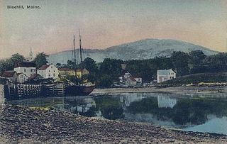
The Blue Hill Historic District encompasses the historic village center of the town of Blue Hill, Maine. The village, established in 1762, is a well-preserved collection of buildings, many of them built before 1840. Most of the older buildings are residential in character; the modest collection of commercial and civic buildings were mostly built between 1880 and 1940. The district was listed on the National Register of Historic Places in 1980.
The Col. Charles and Mary Ann Jarvis Homestead is a historic house at 10 Surry Road in Ellsworth, Maine. Built in 1828, the house is architecturally significant as a fine example of transitional Federal-Greek Revival styling, based in part on the publications of Asher Benjamin. It is historically notable for its association with Charles Jarvis, a major landowner in the region. Jarvis was also an active participant in the military preparations of the bloodless Aroostook War, resulting from a long-running boundary dispute with neighboring New Brunswick. Jarvis' daughter, Ann Francis Greely, was also Hancock County's first female doctor, and a local activist for women's rights and temperance. The house was listed on the National Register of Historic Places in 2004.

Lincoln Pioneer Village is a memorial along the Ohio River in Rockport, Spencer County, Indiana to President Abraham Lincoln who lived in the county during his boyhood years. It was built in 1934 and 1935 in the city park by the Works Progress Administration. George Honig, an artist and sculptor from Spencer County, designed the memorial. He also oversaw the building of the pioneer village replica, which was sponsored by the Spencer County Historical Society and the Rockport City Council. It was listed as a historic district on the National Register of Historic Places on April 20, 1998.

The Hannibal Hamlin House is a historic house at 15 5th Street in Bangor, Maine. Built c. 1848–51, this well-preserved Italianate house was the home of U.S. Vice President Hannibal Hamlin from 1862 until his death in 1891. From 1933 until 2007 it served as the official residence of the president of Bangor Theological Seminary. It was listed on the National Register of Historic Places in 1979.

The Nathaniel Cobb and Lucretia Baily Deering House is a historic building located in Osage, Iowa, United States. The house served as the residence for a prominent politician. Nathaniel Cobb Deering, for whom this house was named, was involved in a variety of pursuits from his native Maine to the California Gold Rush to his adoptive state of Iowa. A Republican, he represented Iowa's 4th congressional district in the United States House of Representatives. He was friends with Hannibal Hamlin, who served as Abraham Lincoln's first term Vice-President, from the time they served together in the Maine House of Representatives. Hamlin reportedly visited Deering here in Osage. The front two-story portion of the brick house built in 1862, and Deering had the back 1½-story section built in 1867. He died here in 1887, and his second wife, Lucetia, died here in 1919. The house was listed on the National Register of Historic Places in 2001.
The Charlotte Center Historic District encompasses the historic 19th-century town center of Charlotte, Vermont. Settled c. 1790 and developed mainly in the mid-19th century, the village, stretched along Church Hill Road west of Hinesburg Road, retains a well-preserved 19th-century atmosphere of residential, civic, and commercial buildings. The district was listed on the National Register of Historic Places in 1984.


