Old Town, Maine

Last updated

Old Town, Maine
Flag of Old Town, Maine.svg
Seal of Old Town, Maine.png
Map of Maine highlighting Old Town.png
Location of Old Town, Maine
Usa edcp location map.svg
Red pog.svg
Old Town
Location in the United States
Coordinates: 44°56′35″N68°40′35″W / 44.94306°N 68.67639°W / 44.94306; -68.67639
CountryUnited States
State Maine
County Penobscot
Settled1774
Incorporated (town)March 16, 1840
Incorporated (city)March 30, 1891
Government
   Mayor Kyle Smart
Area
[1]
  Total43.24 sq mi (111.98 km2)
  Land38.81 sq mi (100.52 km2)
  Water4.43 sq mi (11.46 km2)
Elevation
108 ft (33 m)
Population
 (2020)
  Total7,431
  Density191.47/sq mi (73.93/km2)
Time zone UTC−5 (Eastern (EST))
  Summer (DST) UTC−4 (EDT)
ZIP codes
04468, 04489 (Stillwater)
Area code 207
FIPS code 23-55225
GNIS feature ID0572733
Website www.old-town.org

Old Town is a city in Penobscot County, Maine, United States. The population was 7,431 at the 2020 census. [2] The city's developed area is chiefly located on the relatively large Marsh Island, but its boundaries extend beyond it. The island is surrounded and defined by the Penobscot River to the east and the Stillwater River to the west.

Contents

History

Abenaki Indians called it Pannawambskek, meaning "where the ledges spread out," referring to rapids and drops in the river bed. The French established a Jesuit Catholic mission here in the 1680s. Nearly a century later after Great Britain took over French territory following its victory in the Seven Years' War, the area was settled by English pioneers in 1774. The name Old Town derives from "Indian Old Town", which was the English name for the largest Penobscot Indian village, now known as Indian Island.

Located within the city limits but on its own island in the Penobscot River, the reservation is the current and historical home of the Penobscot Nation. [3]

In 1820, when the present city was set off from neighboring Orono (named for a Penobscot sachem), it was given the name Old Town because it contained the Penobscot village. Over time, the Penobscot village ceased to be called Old Town, and the name migrated to the much newer American settlement across the river. [4]

Old Town may be best known for Old Town Canoe Co., a major manufacturer of canoes and kayaks, which has been based in the city for more than 100 years. The city's location along a series of rapids in the Penobscot River, near the head of tide just downstream in Bangor, made it an ideal location in the 1800s to marshal the water power for mills to process lumber from the millions of board feet of spruce and pine logs floated annually down the Penobscot. [5]

Today many residents work for the University of Maine in Orono and the Eastern Maine Medical Center in Bangor, the two largest employers in the area. Old Town is home to the Nine Dragons Paper Holdings Limited-owned Old Town paper mill. [6]

The city of Old Town includes Treat-Webster Island (a.k.a. "French Island"), a predominantly residential neighborhood located on a small island in the middle of the Penobscot River. French Island is the intermediate land mass between Milford and Old Town; it is connected on either side by a bridge.

Geography

Old Town is located at 44°56′35″N68°40′35″W / 44.94306°N 68.67639°W / 44.94306; -68.67639 (44.943047, −68.676461). [7]

According to the United States Census Bureau, the city has a total area of 43.28 square miles (112.09 km2), of which 38.85 square miles (100.62 km2) is land and 4.43 square miles (11.47 km2) is water. [8] With its business district located on an island, Old Town is drained by the Stillwater River and Penobscot River.

A small area north of Stillwater Avenue on the western side of the Stillwater River is recognized by the United States Postal Service as "Stillwater," and has its own post office and ZIP code. The Census Bureau (as of 2024) does not recognize Stillwater and counts that area as part of Old Town.

The city is crossed by Interstate 95, U. S. Route 2 and 2A, and state routes 16, 43 and 116. It borders the towns of Orono to the south, Glenburn to the west, Hudson to the northwest, Alton and Argyle Township to the north, and (separated by water) is near Milford east, and Bradley to the southeast.

Climate

This climatic region is typified by large seasonal temperature differences, with warm to hot (and often humid) summers and cold (sometimes severely cold) winters. According to the Köppen Climate Classification system, Old Town has a humid continental climate, abbreviated "Dfb" on climate maps. [9]

Climate data for Old Town, Maine
MonthJanFebMarAprMayJunJulAugSepOctNovDecYear
Mean daily maximum °F (°C)29
(−2)
31
(−1)
41
(5)
53
(12)
66
(19)
75
(24)
80
(27)
78
(26)
69
(21)
58
(14)
45
(7)
32
(0)
55
(13)
Mean daily minimum °F (°C)10
(−12)
11
(−12)
22
(−6)
33
(1)
43
(6)
52
(11)
58
(14)
56
(13)
49
(9)
39
(4)
29
(−2)
16
(−9)
35
(2)
Average precipitation inches (mm)3.2
(81)
2.6
(66)
3.2
(81)
3.4
(86)
3.1
(79)
3.4
(86)
3.1
(79)
2.9
(74)
3.6
(91)
3.8
(97)
4
(100)
3.1
(79)
39.6
(1,010)
Source: Weatherbase [10]

Demographics

Historical population
CensusPop.Note
1840 2,342
1850 3,08731.8%
1860 3,86025.0%
1870 4,52917.3%
1880 3,395−25.0%
1890 5,31256.5%
1900 5,7638.5%
1910 6,3179.6%
1920 6,95610.1%
1930 7,2664.5%
1940 7,6885.8%
1950 8,2617.5%
1960 8,6264.4%
1970 9,0575.0%
1980 8,422−7.0%
1990 8,317−1.2%
2000 8,130−2.2%
2010 7,840−3.6%
2020 7,431−5.2%
U.S. Decennial Census [11]
Center Street Center Street in Old Town, Maine.jpg
Center Street

2010 census

As of the census [12] of 2010, there were 7,840 people, 3,382 households, and 1,884 families living in the city. The population density was 201.8 inhabitants per square mile (77.9/km2). There were 3,665 housing units at an average density of 94.3 per square mile (36.4/km2). The racial makeup of the city was 93.1% White, 0.9% African American, 1.6% Native American, 1.8% Asian, 0.1% Pacific Islander, 0.3% from other races, and 2.2% from two or more races. Hispanic or Latino of any race were 1.3% of the population.

There were 3,382 households, of which 24.8% had children under the age of 18 living with them, 40.7% were married couples living together, 11.7% had a female householder with no husband present, 3.4% had a male householder with no wife present, and 44.3% were non-families. 27.0% of all households were made up of individuals, and 10.7% had someone living alone who was 65 years of age or older. The average household size was 2.31 and the average family size was 2.76.

The median age in the city was 33 years. 17.9% of residents were under the age of 18; 20.4% were between the ages of 18 and 24; 24.3% were from 25 to 44; 23.6% were from 45 to 64; and 13.8% were 65 years of age or older. The gender makeup of the city was 48.3% male and 51.7% female.

2000 census

As of the census [13] of 2000, there were 8,130 people, 3,426 households, and 1,993 families living in the city. The population density was 212.3 inhabitants per square mile (82.0/km2). There were 3,686 housing units at an average density of 96.3 per square mile (37.2/km2). The racial makeup of the city was 94.62% White, 0.65% African American, 1.48% Native American, 1.83% Asian, 0.04% Pacific Islander, 0.28% from other races, and 1.09% from two or more races. Hispanic or Latino of any race were 0.52% of the population.

There were 3,426 households, out of which 26.1% had children under the age of 18 living with them, 44.7% were married couples living together, 10.1% had a female householder with no husband present, and 41.8% were non-families. 29.1% of all households were made up of individuals, and 11.7% had someone living alone who was 65 years of age or older. The average household size was 2.30 and the average family size was 2.83.

Pushaw Lake Pushaw Lake.jpg
Pushaw Lake

In the city, the population was spread out, with 20.0% under the age of 18; 18.3% from 18 to 24; 27.0% from 25 to 44; 20.8% from 45 to 64; and 13.9% who were 65 years of age or older. The median age was 34 years. For every 100 females, there were 91.2 males. For every 100 females age 18 and over, there were 90.8 males.

The median income for a household in the city was $29,886, and the median income for a family was $40,589. Males had a median income of $32,961 versus $23,723 for females. The per capita income for the city was $16,100. About 11.8% of families and 18.6% of the population were below the poverty line, including 14.6% of those under age 18 and 14.6% of those age 65 or over.

Education

Logo for RSU #34 RSUlogoSide.png
Logo for RSU #34

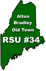
Old Town is part of Regional School Unit (RSU) #34, which includes the towns of Alton, Bradley, and Old Town. The RSU is composed of five schools: Alton Elementary School, Viola Rand Elementary School, Old Town Elementary School, Leonard Middle School, and Old Town High School. [14] In 2006–2007 the school changed its mascot from the Old Town Indians to the Old Town Coyotes. [15] [16] A new community project to renovate the high school track and bolster the school's athletic facilities broke ground in 2013. [17] Old Town's school colors are green and white.

Government

Old Town uses a city council with seven elected councilors, including a Council President. As of March 2020, the current mayor of Old Town is David Mahan. [20]

Historic buildings

Listed in the National Register of Historic Places:

Sites of interest

Notable people

Penobscot office on Indian Island Penobscot-office.jpg
Penobscot office on Indian Island

Related Research Articles

<span class="mw-page-title-main">Penobscot County, Maine</span> County in Maine, United States

Penobscot County is a county in the U.S. state of Maine, named for the Penobscot people in Wabanakik. As of the 2020 census, the population was 152,199, making it the third-most-populous county in Maine. Its county seat is Bangor. The county was established on February 15, 1816, from part of Hancock County when the area was still part of Massachusetts. Penobscot County is home to the University of Maine.

<span class="mw-page-title-main">Ludlow, Maine</span> Town in the state of Maine, United States

Ludlow is a town in Aroostook County, Maine, United States. The population was 434 at the 2020 census.

Alton is a town in Penobscot County, Maine, United States. It is part of the Bangor Metropolitan Statistical Area. The population was 829 at the 2020 census. The community is named after an Alton in England.

Chester is a town in Penobscot County, Maine, United States. The population was 549 at the 2020 census.

Edinburg is a town in Penobscot County, Maine, United States. The population was 134 at the 2020 census. It is part of the Bangor Metropolitan Statistical Area. It is located between the towns of Argyle and Howland along Maine State Route 116 on the west bank of the Penobscot River.

Glenburn is a town in Penobscot County, Maine, United States. The population was 4,648 at the 2020 census. When originally incorporated in 1822, it was called "Dutton" in honor of Bangor's Samuel Dutton, a judge and founder of the Bangor Theological Seminary. It was renamed the Town of Glenburn on March 18, 1837.

<span class="mw-page-title-main">Mattawamkeag, Maine</span> Town in the state of Maine, United States

Mattawamkeag is a town in Penobscot County, Maine, United States, located where the Mattawamkeag River joins the Penobscot River. The population was 596 at the 2020 census. The village of Mattawamkeag is in the southwestern part of the town.

Orrington is a town on the Penobscot River estuary in Penobscot County, Maine, United States. The population was 3,812 at the 2020 census.

Passadumkeag is a town on the east bank of the Penobscot River at the confluence with the Passadumkeag River in Penobscot County, Maine, United States. The population was 356 at the 2020 census. Passadumkeag is a word of the Penobscot people meaning "quick water".

<span class="mw-page-title-main">Veazie, Maine</span> Town in the state of Maine, United States

Veazie is a town in Penobscot County, Maine, United States. The population was 1,814 at the 2020 census. The town is named after General Samuel Veazie, an early lumber baron and railroad operator. Veazie was originally part of Bangor, using Penobscot River water power to operate sawmills. It became a separate town in 1853 because Gen. Veazie, its wealthiest citizen, thought Bangor's property taxes were too high.

<span class="mw-page-title-main">Belfast, Maine</span> City in Maine, United States

Belfast is a city in Waldo County, Maine, United States. As of the 2020 census, the city population was 6,938. Located at the mouth of the Passagassawakeag River estuary on Belfast Bay and Penobscot Bay. Belfast is the county seat of Waldo County. Its seaport has a wealth of antique architecture in several historic districts, and remains popular with tourists.

<span class="mw-page-title-main">Frankfort, Maine</span> Town in the state of Maine, United States

Frankfort is a town on the Penobscot River estuary in Waldo County, Maine, United States. The population was 1,231 at the 2020 census.

<span class="mw-page-title-main">Prospect, Maine</span> Town in the state of Maine, United States

Prospect is a town in Waldo County, Maine, United States. The population was 698 at the 2020 census.

<span class="mw-page-title-main">Millinocket, Maine</span> Town in the state of Maine, United States

Millinocket is a town in Penobscot County, Maine, United States. The population was 4,114 at the 2020 census.

<span class="mw-page-title-main">Orono, Maine</span> Town in Maine, United States

Orono is a town in Penobscot County, Maine, United States. Located on the Penobscot and Stillwater rivers, it was first settled by American colonists in 1774. They named it in honor of Chief Joseph Orono, a sachem of the indigenous Penobscot nation who long occupied this territory.

Bucksport is a census-designated place (CDP) in the town of Bucksport in Hancock County, Maine, United States. The population was 2,885 at the 2010 census, down from 2,970 at the 2000 census.

Milford is a town in Penobscot County, Maine, United States. It is located across the Penobscot River from the city of Old Town. The population of Milford was 3,069 at the 2020 census. The town's slogan is the "Best little town by a dam site," referring to the Milford Dam abutting Milford on the Penobscot River, south of the Penobscot Indian Island Reservation.

Orono is a census-designated place (CDP) consisting of the eastern portion of the town of Orono in Penobscot County, Maine, United States. The population of the CDP was 9,474 at the 2010 census.

<span class="mw-page-title-main">Searsport, Maine</span> Town in Maine, United States

Searsport is an incorporated town and deep water seaport located at the confluence of the Penobscot River estuary and the Penobscot Bay immediately northwest of Sears Island and Cape Jellison in Waldo County, Maine, United States. The population was 2,649 at the 2020 census. Searsport includes the village of North Searsport. The town is known as "the home of the famous sea captains" and the "Antique Capital of Maine".

<span class="mw-page-title-main">Winterport, Maine</span> Town in the state of Maine, United States

Winterport is a town in Waldo County, Maine, United States. The population was 3,817 at the 2020 census. The Winterport Historic District, extending several blocks along Main Street, was listed on the National Register of Historic Places in 1975.

References

  1. "2020 U.S. Gazetteer Files". United States Census Bureau. Retrieved April 8, 2022.
  2. "Census - Geography Profile: Old Town city, Maine". United States Census Bureau . Retrieved January 8, 2022.
  3. Coolidge, Austin J.; John B. Mansfield (1859). A History and Description of New England. Boston, Massachusetts: A.J. Coolidge. pp.  240–241. coolidge mansfield history description new england 1859.
  4. Varney, George J. (1886), Gazetteer of the state of Maine. Old Town, Boston: Russell
  5. Old Town's Rich Heritage Archived 2007-09-01 at the Wayback Machine , Old Town website
  6. Robinson, Steve (March 29, 2023). "High Electricity, Fiber Costs Shutter Old Town Mill". The Maine Wire. Archived from the original on June 2, 2023. Retrieved August 25, 2023.
  7. "US Gazetteer files: 2010, 2000, and 1990". United States Census Bureau. February 12, 2011. Retrieved April 23, 2011.
  8. "US Gazetteer files 2010". United States Census Bureau. Archived from the original on July 2, 2012. Retrieved November 23, 2012.
  9. Climate Summary for Old Town, Maine
  10. "Weatherbase.com". Weatherbase. 2013. Retrieved on October 20, 2013.
  11. "Census of Population and Housing". Census.gov. Retrieved June 4, 2015.
  12. "U.S. Census website". United States Census Bureau . Retrieved November 23, 2012.
  13. "U.S. Census website". United States Census Bureau . Retrieved January 31, 2008.
  14. "Regional School Unit #34". RSU #34. Retrieved January 9, 2017.
  15. Bangor Daily News: 3/11/2014
  16. Portland Press Herald: 5/31/2014
  17. "Community support enables Old Town High School to begin building new track as part of proposed $1.5 million athletic facilities project". May 7, 2013.
  18. RSU#34
  19. Montessori School
  20. "City Council ~ City of Old Town, Maine". City of Old Town. Retrieved March 10, 2020.
  21. St. Anne's Church and Mission Site Archived 2015-01-20 at the Wayback Machine (1830)
  22. St. James Episcopal Church Archived 2015-01-20 at the Wayback Machine (1892)
  23. Old Town Museum
  24. "Parks - City of Old Town, MaineĀ". Archived from the original on July 9, 2013. Retrieved June 12, 2013.
  25. Anstead, Alicia (October 14, 1995). "Molly Spotted Elk Dancing her way across the globe". Bangor Daily News. Bangor, Maine. p. 1. Retrieved January 20, 2020.