Related Research Articles

Aroostook County is a county in the U.S. state of Maine along the Canada–U.S. border. As of the 2020 census, the population was 67,105. Its county seat is Houlton, with offices in Caribou and Fort Kent.

Hodgdon is a rural town in Aroostook County, Maine, United States. The town borders the province of New Brunswick, Canada to the east and Houlton to the north. Hodgdon's population was 1,290 at the 2020 census.

The Aroostook War, or the Madawaska War, was a military and civilian-involved confrontation in 1838–1839 between the United States and the United Kingdom over the international boundary between the British colony of New Brunswick and the U.S. state of Maine. The term "war" was rhetorical; local militia units were called out but never engaged in actual combat. The event is best described as an international incident.
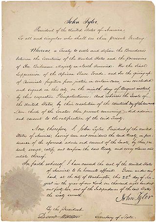
The Webster–Ashburton Treaty, signed August 9, 1842, was a treaty that resolved several border issues between the United States and the British North American colonies. Signed under John Tyler's presidency, it resolved the so-called Aroostook War. The provisions of the treaty included:

The Berkshires are a highland geologic region located in the western parts of Massachusetts and northwest Connecticut. The term "Berkshires" is normally used by locals in reference to the portion of the Vermont-based Green Mountains that extend south into western Massachusetts; the portion extending further south into northwestern Connecticut is grouped with the Connecticut portion of the Taconic Mountains and referred to as either the Northwest Hills or Litchfield Hills.
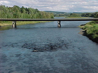
The Aroostook River is a 112-mile-long (180 km) tributary of the Saint John River in the U.S. state of Maine and the Canadian province of New Brunswick. Its basin is the largest sub-drainage of the Saint John River.
The Northeastern coastal forests are a temperate broadleaf and mixed forests ecoregion of the northeast and middle Atlantic region of the United States. The ecoregion covers an area of 34,630 sq miles (89,691 km2) encompassing the Piedmont and coastal plain of seven states, extending from coastal southwestern Maine, southeastern New Hampshire, eastern Massachusetts, and Rhode Island, southward through Connecticut, New York State, New Jersey, southeast Pennsylvania, Delaware and Maryland.

The International Railway of Maine was a historic railroad constructed by the Canadian Pacific Railway (CPR) between Lac-Mégantic, Quebec, and Mattawamkeag, Maine, closing a key gap in the railway's transcontinental main line to the port of Saint John, New Brunswick.

Green Country, sometimes referred to as Northeast Oklahoma, is the northeastern portion of the U.S. state of Oklahoma, which lies west of the northern half of Arkansas, the southwestern corner the way of Missouri, and south of Kansas.

The North Maine Woods is the northern geographic area of the state of Maine in the United States. The thinly populated region is overseen by a combination of private individual and private industrial owners and state government agencies, and is divided into 155 unincorporated townships within the NMW management area. There are no towns or paved roads.

The Katahdin Iron Works is a Maine state historic site located in the unorganized township of the same name. It is the site of an ironworks which operated from 1845 to 1890. In addition to the kilns of the ironworks, the community was served by a railroad and had a 100-room hotel. The site was listed on the National Register of Historic Places in 1969.
The Tinker Dam is a hydroelectric dam built in Tinker on the Aroostook River in the Canadian province of New Brunswick, and operated jointly by WPS Energy and NB Power. Its power house has a capacity of 34 megawatts.

The New England-Acadian forests are a temperate broadleaf and mixed forest ecoregion in North America that includes a variety of habitats on the hills, mountains and plateaus of New England and New York State in the Northeastern United States, and Quebec and the Maritime Provinces of Eastern Canada.
The Daaquam River is a river primarily flowing in the administrative region of Chaudière-Appalaches, at South of Quebec in Canada and northern Maine, in United States. The river runs from its source, south of Sainte-Justine, northeast across the Canada–United States border to the Northwest Branch of the Saint John River in Maine.

Savage Mountain is an anticline extending from Bedford County, Pennsylvania southwest into Western Maryland. It is the western side of the Ridge-and-Valley Appalachians, and the eastern portion of the ridge forms the border of Garrett and Allegany Counties of Maryland.

The Eastern Great Lakes and Hudson Lowlands region extends along the south shores of Lake Erie and Lake Ontario and the St. Lawrence River to Lake Champlain, and south down the Hudson River. It is primarily within the state of New York, with smaller portions in Vermont, Pennsylvania, and Ohio. In the north it meets the Mixedwood Plains Ecozone of Canada in eastern Ontario and southern Quebec. It is mostly temperate deciduous forest and agricultural land.
The West Branch Pocwock Stream is a tributary of the Pocwock River flowing in:

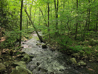
The Northeastern Highlands ecoregion is a Level III ecoregion designated by the United States Environmental Protection Agency (EPA) in the U.S. states of Vermont, New Hampshire, Massachusetts, Maine, Connecticut, New York, New Jersey, and Pennsylvania. The ecoregion extends from the northern tip of Maine and runs south along the Appalachian Mountain Range into eastern Pennsylvania. Discontiguous sections are located among New York's Adirondack Mountains and the Catskill Range. The largest portion of the Northeastern Highlands ecoregion encompasses several sub mountain ranges including the Berkshires, Green Mountains, Taconic, and White Mountains.
References
- ↑ Phillips Bevan, G. (1882). Google Book Search Beta . Retrieved 2006-05-04., showing page 122 of Bevan, G. Phillips (1882). A Handbook of the Industries of the British Isles and the United States.
- ↑ Winsor, Justin (1888). Google Book Search Beta . Retrieved 2006-05-04., showing page 176 of Winsor, Justin (1884). Narrative and Critical History of America.
- ↑ "Aroostook War". Global Security.org. Retrieved 2006-05-04.
- ↑ Google Book Search Beta. 1916. Retrieved 2006-05-04., showing page 33 of United States Congress (1916). Hearings Before the Committee on Foreign Affairs of the House of Representatives.
- ↑ Olson, D. M, E. Dinerstein; et al. (2001). "Terrestrial Ecoregions of the World: A New Map of Life on Earth". BioScience . 51 (11): 933–938. doi: 10.1641/0006-3568(2001)051[0933:TEOTWA]2.0.CO;2 .
{{cite journal}}: CS1 maint: multiple names: authors list (link) - ↑ "Chapter 1: Northern Maine and New Hampshire". United Divide: A Linear Portrait of the USA/Canada Border. The Center for Land Use Interpretation. Winter 2015.
| | This Maine state location article is a stub. You can help Wikipedia by expanding it. |