Orono (CDP), Maine

Last updated

Orono, Maine
USA Maine location map.svg
Red pog.svg
Orono, Maine
Location within the state of Maine
Coordinates: 44°53′20″N68°40′16″W / 44.88889°N 68.67111°W / 44.88889; -68.67111
CountryUnited States
State Maine
County Penobscot
Area
[1]
  Total7.71 sq mi (19.98 km2)
  Land7.05 sq mi (18.27 km2)
  Water0.66 sq mi (1.71 km2)
Elevation
125 ft (38 m)
Population
 (2020)
  Total10,185
  Density1,444.07/sq mi (557.54/km2)
Time zone UTC-5 (Eastern (EST))
  Summer (DST) UTC-4 (EDT)
ZIP codes
04469, 04473
Area code 207
FIPS code 23-55575
GNIS feature ID0572773

Orono is a census-designated place (CDP) consisting of the eastern portion of the town of Orono in Penobscot County, Maine, United States. The population of the CDP was 9,474 at the 2010 census. [2]

Contents

Geography

Orono is located at 44°53′19″N68°40′16″W / 44.88861°N 68.67111°W / 44.88861; -68.67111 (44.888769, −68.671153). [3] The Orono CDP consists of all of the town east of Interstate 95, including the primary settled area in the town.

According to the United States Census Bureau, the CDP has a total area of 7.7 square miles (20.0 km2), of which 7.1 square miles (18.3 km2) is land and 0.66 square miles (1.7 km2), or 8.55%, is water. [2]

Demographics

Historical population
CensusPop.Note
2020 10,185
U.S. Decennial Census [4]

As of the census [5] of 2000, there were 8,253 people, 2,343 households, and 1,047 families residing in the CDP. The population density was 1,133.1 inhabitants per square mile (437.5/km2). There were 2,472 housing units at an average density of 339.4 per square mile (131.0/km2). The racial makeup of the CDP was 93.30% White, 1.47% Black or African American, 0.95% Native American, 2.57% Asian, 0.06% Pacific Islander, 0.55% from other races, and 1.11% from two or more races. Hispanic or Latino of any race were 1.27% of the population.

There were 2,343 households, out of which 20.7% had children under the age of 18 living with them, 33.8% were married couples living together, 8.5% had a female householder with no husband present, and 55.3% were non-families. 33.0% of all households were made up of individuals, and 10.8% had someone living alone who was 65 years of age or older. The average household size was 2.19 and the average family size was 2.81.

In the CDP, the population was spread out, with 10.7% under the age of 18, 51.8% from 18 to 24, 15.9% from 25 to 44, 12.4% from 45 to 64, and 9.2% who were 65 years of age or older. The median age was 22 years. For every 100 females, there were 102.2 males. For every 100 females age 18 and over, there were 101.5 males.

The median income for a household in the CDP was $30,262, and the median income for a family was $51,613. Males had a median income of $34,500 versus $24,602 for females. The per capita income for the CDP was $14,252. About 10.8% of families and 27.5% of the population were below the poverty line, including 24.5% of those under age 18 and 6.6% of those age 65 or over.

Related Research Articles

<span class="mw-page-title-main">Summit, Arizona</span> CDP in Pima County, Arizona

Summit is a census-designated place (CDP) in Pima County, Arizona, United States. The population was 3,702 at the 2000 census.

<span class="mw-page-title-main">Trinity, Florida</span> CDP in Florida, United States

Trinity is a census-designated place (CDP) in Pasco County, Florida, United States. The population was 10,907 in 2010, according to the most recent census. The Trinity Community is named after Trinity College of Florida, a Bible college founded in 1932, when it relocated to the first occupied site in the communities developed by James Gills in the late 1980s. The main plaza is found near the high school, known as Mitchell Ranch Plaza. Trinity is located at the junction where Pasco, Hillsborough and Pinellas Counties meet. The community of Longleaf is located in Trinity and it is believed that the “Welcome Plank” originated in Longleaf.

<span class="mw-page-title-main">Lake of the Woods, Illinois</span> Census-designated place in Illinois, United States

Lake of the Woods is a census-designated place (CDP) in Champaign County, Illinois, United States. The population was 2403 at the 2020 census. Lake of the Woods is in Mahomet Township and mostly surrounded by the northeast part of the village of Mahomet.

Coyne Center is a census-designated place (CDP) in Rock Island County, Illinois, United States. The population was 827 at the 2010 census.

<span class="mw-page-title-main">Churchill, Ohio</span> Census-designated place in Ohio, United States

Churchill is a census-designated place in Liberty Township, Trumbull County, Ohio, United States. The population was 2,176 at the 2020 census. It is part of Youngstown–Warren metropolitan area. The community was named for a hilltop church near the original townsite.

<span class="mw-page-title-main">Willington, South Carolina</span> CDP in South Carolina, United States

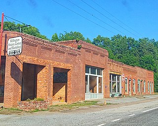
Willington is a census-designated place (CDP) in McCormick County, South Carolina, United States. The population was 177 at the 2000 census.

<span class="mw-page-title-main">Salem, South Carolina</span> Town in South Carolina, United States

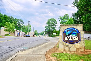
Salem is a U.S. town in Oconee County, South Carolina. The population was 135 at the 2010 United States Census.

Wedgefield is a census-designated place (CDP) in Sumter County, South Carolina, United States. The population was 1,544 at the 2000 census.

<span class="mw-page-title-main">Fort Kent (CDP), Maine</span> Census-designated place in Maine, United States

Fort Kent is a census-designated place (CDP) that comprises the main village in the town of Fort Kent in Aroostook County, Maine, United States. In 2010, Fort Kent's population was 2,488 of 4,097 for the entire town.

<span class="mw-page-title-main">Madawaska (CDP), Maine</span> Census-designated place in Maine, United States

Madawaska is a census-designated place (CDP) comprising the main village within the town of Madawaska in Aroostook County, Maine, United States. The population of the CDP was 2,967 at the 2010 census, out of a population of 4,035 for the entire town.

Bar Harbor is a census-designated place (CDP) in the town of Bar Harbor in Hancock County, Maine, United States. The CDP population was 2,552 at the 2010 census, out of a population of 5,235 in the town of Bar Harbor as a whole.

Bucksport is a census-designated place (CDP) in the town of Bucksport in Hancock County, Maine, United States. The population was 2,885 at the 2010 census, down from 2,970 at the 2000 census.

East Millinocket is a census-designated place (CDP) consisting of the main settlement in the town of East Millinocket in Penobscot County, Maine, United States. The population was 1,567 at the 2010 census.

Hampden is a census-designated place (CDP) consisting of the eastern portion of the town of Hampden in Penobscot County, Maine, United States. The population of the CDP was 4,343 at the 2010 census.

Milford is a census-designated place (CDP) consisting of the main area of settlement within the town of Milford in Penobscot County, Maine, United States. The population was 2,233 at the 2010 census.

Millinocket is a census-designated place (CDP) comprising most of the developed land within the town of Millinocket in Penobscot County, Maine, United States. The population of the CDP was 4,466 at the 2010 census.

Newport is a census-designated place (CDP) consisting of the main area of settlement within the town of Newport in Penobscot County, Maine, United States. The population of the CDP was 1,776 at the 2010 census.

<span class="mw-page-title-main">Milo (CDP), Maine</span> CDP in Maine, United States

Milo is a census-designated place (CDP) in the town of Milo in Piscataquis County, Maine, United States. The population was 1,898 at the 2000 census.

Pittsfield is a census-designated place (CDP) in the town of Pittsfield in Somerset County, Maine, United States. The population was 3,217 at the 2000 census.

<span class="mw-page-title-main">Searsport (CDP), Maine</span> CDP in Maine, United States

Searsport is a census-designated place (CDP) in the town of Searsport in Waldo County, Maine, United States. The population was 1,102 at the 2000 census.

References

  1. "2020 U.S. Gazetteer Files". United States Census Bureau. Retrieved April 8, 2022.
  2. 1 2 "Geographic Identifiers: 2010 Demographic Profile Data (G001): Orono CDP, Maine". U.S. Census Bureau, American Factfinder. Archived from the original on February 12, 2020. Retrieved November 20, 2012.
  3. "US Gazetteer files: 2010, 2000, and 1990". United States Census Bureau. February 12, 2011. Retrieved April 23, 2011.
  4. "Census of Population and Housing". Census.gov. Retrieved June 4, 2016.
  5. "U.S. Census website". United States Census Bureau . Retrieved January 31, 2008.