
Penobscot County is a county in the U.S. state of Maine, named for the Penobscot people in Wabanakik. As of the 2020 census, the population was 152,199, making it the third-most-populous county in Maine. Its county seat is Bangor. The county was established on February 15, 1816, from part of Hancock County when the area was still part of Massachusetts. Penobscot County is home to the University of Maine.

Mattawamkeag is a town in Penobscot County, Maine, United States, located where the Mattawamkeag River joins the Penobscot River. The population was 596 at the 2020 census. The village of Mattawamkeag is in the southwest part of the town.

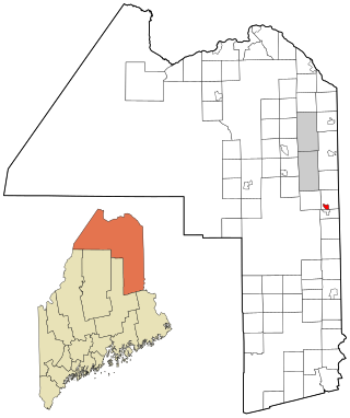
Mount Chase is a town in Penobscot County, Maine, United States. The population was 187 at the 2020 census.
Patten is a small town in Penobscot County, Maine, United States. At the 2020 census, the population was 881. The village of Patten is in the northeastern part of the town.
Brownville Junction is a census-designated place (CDP) in the town of Brownville, Piscataquis County, Maine, United States. It is west-central part of the town, on the west side of the Pleasant River, a south-flowing tributary of the Piscataquis River and part of the Penobscot River watershed. Maine State Route 11 passes through the community, leading south 3 miles (5 km) to Brownville village and 7 miles (11 km) to Milo, and northeast 31 miles (50 km) to Millinocket.

Little Falls is a census-designated place (CDP) in the town of Gorham in Cumberland County, Maine, United States. The population of the CDP was 708 at the 2010 census. Prior to 2010, Little Falls was part of the Little Falls-South Windham census-designated place.
Bucksport is a census-designated place (CDP) in the town of Bucksport in Hancock County, Maine, United States. The population was 2,885 at the 2010 census, down from 2,970 at the 2000 census.
Mars Hill is a census-designated place (CDP) comprising the main village within the town of Mars Hill in Aroostook County, Maine, United States. The population of the CDP was 980 at the 2010 census, out of a population of 1,493 for the entire town. Prior to 2010, the village was part of the Mars Hill-Blaine CDP.

Washburn is a census-designated place (CDP) comprising the main village within the town of Washburn in Aroostook County, Maine, United States. The population of the CDP was 997 at the 2010 census, out of a population of 1,687 for the entire town.
Castine is a census-designated place (CDP) in the town of Castine in Hancock County, Maine, United States. The CDP population was 1,029 at the 2010 census, out of 1,366 people in the town as a whole.

Damariscotta is a census-designated place (CDP) comprising the main village of the town of Damariscotta in Lincoln County, Maine, United States. The population was 1,142 at the 2010 census, out of 2,218 in the entire town. In the 2000 census, the village was part of the Damariscotta-Newcastle CDP.
Newcastle is a census-designated place (CDP) comprising the main village of the town of Newcastle in Lincoln County, Maine, United States. The population was 667 at the 2010 census, out of 1,752 in the entire town. In the 2000 census, the village was part of the Damariscotta-Newcastle CDP.

Camden is a census-designated place (CDP) comprising the main village in the town of Camden in Knox County, Maine, United States. The population was 3,570 at the 2010 census, out of 4,850 in the entire town of Camden.
Alfred is a census-designated place (CDP) and the primary village in the town of Alfred, York County, Maine, United States. It is in central York County and the center of the town of Alfred, 4 miles (6 km) northeast of Sanford and 13 miles (21 km) west of Biddeford. U.S. Route 202 passes through the village, leading northeast 23 miles (37 km) to Gorham and southwest through Sanford 20 miles (32 km) to Rochester, New Hampshire. Maine State Route 4 leads south 13 miles (21 km) to North Berwick and leads north out of town with US 202. State Route 111 leads east from Alfred to Biddeford.
Island Falls is a census-designated place (CDP) and the primary village in the town of Island Falls, Aroostook County, Maine, United States. It is in the northwest part of the town, situated on the West Branch Mattawamkeag River, part of the Penobscot River watershed. U.S. Route 2 passes through the village, leading northeast 27 miles (43 km) to Houlton and south 38 miles (61 km) to Mattawamkeag. Maine State Route 159 has its eastern terminus at U.S. 2 in the center of Island Falls and leads west 10 miles (16 km) to Patten. Interstate 95 passes just west of the village of Island Falls, with access from Exit 276 ; I-95 leads northeast to Houlton and southwest 92 miles (148 km) to Bangor.
Oakfield is a census-designated place (CDP) and the primary village in the town of Oakfield, Aroostook County, Maine, United States. It is in the northwestern corner of the town, on both sides of the East Branch Mattawamkeag River. Interstate 95 passes through the CDP, north of the village center, with access from Exit 286. I-95 leads east 18 miles (29 km) to the Canada–United States border at Houlton, and southwest 101 miles (163 km) to Bangor.
Bethel is a census-designated place (CDP) and the primary village in the town of Bethel, Oxford County, Maine, United States. It is in the southwestern part of the town, south of the Androscoggin River. U.S. Route 2 passes through the northwest side of the CDP, leading northeast 23 miles (37 km) to Rumford and west 22 miles (35 km) to Gorham, New Hampshire. Maine State Route 5 joins Route 2 in Bethel but runs south through the village center and continues southwest 36 miles (58 km) to Fryeburg. State Route 26 leads southeast from Bethel 24 miles (39 km) to South Paris.
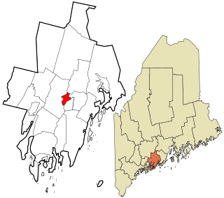
Corinna is a census-designated place (CDP) and the primary village in the town of Corinna, Penobscot County, Maine, United States. It is in the southern part of the town, on both sides of the East Branch Sebasticook River, part of the Kennebec River watershed.
Patten is a census-designated place (CDP) and the primary village in the town of Patten, Penobscot County, Maine, United States. It is in the northeastern part of the town, mostly on the north side of Fish Stream, an eastward-flowing tributary of the West Branch Mattawamkeag River and part of the Penobscot River watershed.
Danforth is a census-designated place (CDP) and the primary village in the town of Danforth, Washington County, Maine, United States. It is in northernmost Washington County, in the northern part of the town of Danforth, and is bordered to the north by the town of Weston in Aroostook County. The village is located on Baskahegan Stream where it originates at the outlet of Crooked Brook Flowage. The Baskahegan is a northwest-flowing tributary of the Mattawamkeag River and part of the Penobscot River watershed.


