Milford (CDP), Maine

Last updated

Milford, Maine
USA Maine location map.svg
Red pog.svg
Milford, Maine
Location within the state of Maine
Coordinates: 44°56′40″N68°38′18″W / 44.94444°N 68.63833°W / 44.94444; -68.63833
CountryUnited States
State Maine
County Penobscot
Area
[1]
  Total3.38 sq mi (8.76 km2)
  Land3.34 sq mi (8.66 km2)
  Water0.04 sq mi (0.11 km2)
Elevation
135 ft (41 m)
Population
 (2020)
  Total2,211
  Density661.38/sq mi (255.39/km2)
Time zone UTC-5 (Eastern (EST))
  Summer (DST) UTC-4 (EDT)
ZIP code
04461
Area code 207
FIPS code 23-45635
GNIS feature ID0571289

Milford is a census-designated place (CDP) consisting of the main area of settlement within the town of Milford in Penobscot County, Maine, United States. The population was 2,233 at the 2010 census. [2]

Contents

Geography

Milford is located at 44°56′39″N68°38′18″W / 44.94417°N 68.63833°W / 44.94417; -68.63833 (44.944402, −68.638394). [3]

According to the United States Census Bureau, the CDP has a total area of 3.4 square miles (8.8 km2), of which 3.4 square miles (8.7 km2) is land and 0.039 square miles (0.1 km2), or 1.20%, is water. [2]

Demographics

Historical population
CensusPop.Note
2020 2,211
U.S. Decennial Census [4]

As of the census [5] of 2000, there were 2,197 people, 906 households, and 587 families residing in the CDP. The population density was 681.0 inhabitants per square mile (262.9/km2). There were 955 housing units at an average density of 296.0 per square mile (114.3/km2). The racial makeup of the CDP was 95.72% White, 0.14% Black or African American, 1.64% Native American, 0.55% Asian, 0.05% Pacific Islander, 0.41% from other races, and 1.50% from two or more races. Hispanic or Latino of any race were 0.64% of the population.

There were 906 households, out of which 30.1% had children under the age of 18 living with them, 51.0% were married couples living together, 10.6% had a female householder with no husband present, and 35.1% were non-families. 23.7% of all households were made up of individuals, and 7.7% had someone living alone who was 65 years of age or older. The average household size was 2.42 and the average family size was 2.87.

In the CDP, the population was spread out, with 22.2% under the age of 18, 12.1% from 18 to 24, 31.7% from 25 to 44, 21.7% from 45 to 64, and 12.4% who were 65 years of age or older. The median age was 36 years. For every 100 females, there were 97.6 males. For every 100 females age 18 and over, there were 93.9 males.

The median income for a household in the CDP was $36,250, and the median income for a family was $42,315. Males had a median income of $31,453 versus $25,227 for females. The per capita income for the CDP was $17,624. About 11.0% of families and 12.2% of the population were below the poverty line, including 10.3% of those under age 18 and 12.1% of those age 65 or over.

Related Research Articles

<span class="mw-page-title-main">Mountain View Acres, California</span> Census-designated place in California, United States

Mountain View Acres is a census-designated place (CDP) in the Victor Valley of the Mojave Desert, within San Bernardino County, California.

Coyne Center is a census-designated place (CDP) in Rock Island County, Illinois, United States. The population was 827 at the 2010 census.

<span class="mw-page-title-main">Milford Mill, Maryland</span> Census-designated place in Maryland, United States

Milford Mill is an unincorporated community and census-designated place in Baltimore County, Maryland, United States. Per the 2020 census, the population was 30,622.

<span class="mw-page-title-main">Sand Ridge, New York</span> CDP in New York, United States

Sand Ridge is a hamlet in Oswego County, New York, United States. The population was 849 at the 2010 census.

<span class="mw-page-title-main">Saugerties South, New York</span> CDP in New York, United States

Saugerties South is a hamlet in Ulster County, New York, United States. The population was 2,442 at the 2020 census.

<span class="mw-page-title-main">Mountain Home, North Carolina</span> Census-designated place in North Carolina, United States

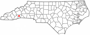
Mountain Home is an unincorporated community and census-designated place (CDP) in Henderson County, North Carolina, United States. The population was 3,622 at the 2010 census, up from 2,169 in 2000. It is part of the Asheville Metropolitan Statistical Area.

<span class="mw-page-title-main">Day Heights, Ohio</span> Census-designated place in Ohio, United States

Day Heights is a census-designated place (CDP) in Clermont County, Ohio, United States. The population was 2,625 at the 2020 census.

<span class="mw-page-title-main">Riceville, Pennsylvania</span> Census-designated place in Pennsylvania, United States

Riceville is a census-designated place in Crawford County, Pennsylvania, United States. The population was 68 at the 2010 census.

<span class="mw-page-title-main">Willington, South Carolina</span> CDP in South Carolina, United States

Willington is a census-designated place (CDP) in McCormick County, South Carolina, United States. The population was 177 at the 2000 census.

<span class="mw-page-title-main">Dryden, Virginia</span> Census-designated place in Virginia, United States

Dryden is an unincorporated community and census-designated place (CDP) in Lee County, Virginia, United States. The population was 1,208 at the 2010 census.

<span class="mw-page-title-main">Summitview, Washington</span> CDP in Washington, United States

Summitview is a census-designated place (CDP) in Yakima County, Washington, United States. The population was 967 at the 2010 census.

<span class="mw-page-title-main">New Milford (CDP), Connecticut</span> Census-designated place in Connecticut, United States

Downtown New Milford is a district/census-designated place (CDP) in Litchfield County, Connecticut, United States. It comprises the main population center within the town of New Milford. As of the 2010 census, the population of Downtown New Milford was 6,523, out of 28,142 in the entire town of New Milford.

<span class="mw-page-title-main">Milford (CDP), New Hampshire</span> Census-designated place in New Hampshire, United States

Milford is a census-designated place (CDP) and the main village in the town of Milford, Hillsborough County, New Hampshire, United States. The population of the CDP was 9,212 at the 2020 census, out of 16,131 in the entire town.

East Millinocket is a census-designated place (CDP) consisting of the main settlement in the town of East Millinocket in Penobscot County, Maine, United States. The population was 1,567 at the 2010 census.

Hampden is a census-designated place (CDP) consisting of the eastern portion of the town of Hampden in Penobscot County, Maine, United States. The population of the CDP was 4,343 at the 2010 census.

Millinocket is a census-designated place (CDP) comprising most of the developed land within the town of Millinocket in Penobscot County, Maine, United States. The population of the CDP was 4,466 at the 2010 census.

Newport is a census-designated place (CDP) consisting of the main area of settlement within the town of Newport in Penobscot County, Maine, United States. The population of the CDP was 1,776 at the 2010 census.

Orono is a census-designated place (CDP) consisting of the eastern portion of the town of Orono in Penobscot County, Maine, United States. The population of the CDP was 9,474 at the 2010 census.

Pittsfield is a census-designated place (CDP) in the town of Pittsfield in Somerset County, Maine, United States. The population was 3,217 at the 2000 census.

<span class="mw-page-title-main">Searsport (CDP), Maine</span> CDP in Maine, United States

Searsport is a census-designated place (CDP) in the town of Searsport in Waldo County, Maine, United States. The population was 999 at the 2020 census.

References

  1. "2020 U.S. Gazetteer Files". United States Census Bureau. Retrieved April 8, 2022.
  2. 1 2 "Geographic Identifiers: 2010 Demographic Profile Data (G001): Milford CDP, Maine". U.S. Census Bureau, American Factfinder. Archived from the original on February 12, 2020. Retrieved November 20, 2012.
  3. "US Gazetteer files: 2010, 2000, and 1990". United States Census Bureau. February 12, 2011. Retrieved April 23, 2011.
  4. "Census of Population and Housing". Census.gov. Retrieved June 4, 2016.
  5. "U.S. Census website". United States Census Bureau . Retrieved January 31, 2008.