Bangor is a city in the U.S. state of Maine, and the county seat of Penobscot County. The city proper has a population of 33,039, making it the state's 3rd largest settlement behind Portland (66,882) and Lewiston (36,221).

Frankfort is a town on the Penobscot River estuary in Waldo County, Maine, United States. The population was 1,124 at the 2010 census.

Penobscot Indian Island Reservation is an Indian reservation for the Penobscot Tribe of Maine, a federally recognized tribe of the Penobscot in Penobscot County, Maine, United States, near Old Town. The population was 610 at the 2010 census. The reservation extends for many miles alongside 15 towns and two unorganized territories in a thin string along the Penobscot River, from its base at Indian Island, near Old Town and Milford, northward to the vicinity of East Millinocket, almost entirely in Penobscot County. A small, uninhabited part of the reservation is in South Aroostook, Aroostook County, by which it passes along its way northward.

The Dummer's War, was a series of battles between New England and the Wabanaki Confederacy who were allied with New France. The eastern theater of the war was fought primarily along the border between New England and Acadia in Maine, as well as in Nova Scotia; the western theater was fought in northern Massachusetts and Vermont at the border between Canada and New England.

Penobscot Bay is an inlet of the Gulf of Maine and Atlantic Ocean in south central Maine. The bay originates from the mouth of Maine's Penobscot River, downriver from Belfast. Penobscot Bay has many working waterfronts including Rockland, Rockport, and Stonington, and Belfast upriver. Penobscot Bay is between Muscongus Bay and Blue Hill Bay, just west of Acadia National Park.
Joseph Orono (1688–1801) was a Penobscot Indian chief or sachem who lived on the Penobscot River in present-day Maine. The town of Orono, Maine, which contains the University of Maine, is named for him.
In the U.S. state of Maine, U.S. Route 2 (US 2) is a principal east–west route through the central portion of the state, extending from the New Hampshire border in Gilead to the town of Houlton near the Canadian border.
Andrew Sockalexis was an American track and field athlete who competed in the 1912 Summer Olympics.
This article shows U.S. Census totals for Penobscot County, Maine, broken down by municipality, from 1900 to 2000.

The Old Fire Engine House is a historic fire station on North Main Avenue in Orono, Maine. Built in 1892, it is a well-preserved example of a late-19th century wooden fire station. It was added to the National Register of Historic Places on September 12, 1985. It is now used by Boy Scout Troop 478, which is in the Katahdin Area Council.

Pushaw Lake is a lake in Penobscot County, Maine, United States about 6.5 miles (10.5 km) north of downtown Bangor and 4.5 mi (7.2 km) west of downtown Orono. The lake is part of the towns of Orono, Old Town, Hudson, and Glenburn. There are roads and private residences along much of the lake, except the southeastern side where the Caribou Bog complex borders the lake. A small dam was constructed in 1920 at the lake's outflow to maintain constant water levels.
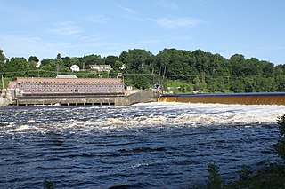
The Veazie Dam was a hydroelectric dam on the Penobscot River between Veazie and Eddington in Penobscot County, Maine. In 2010 the Penobscot River Restoration Trust bought the dam from PPL Corporation based on an agreement that was signed in 2004. Deconstruction of the dam began on July 22, 2013 as a part of an extensive project involving four dams to restore eleven species of sea-run fish to the Penobscot River. The Veazie Dam was the furthest downstream of the dams on the Penobscot River; now the Milford and Orono Dam dams are furthest downstream, albeit on separate side of Marsh Island. The Great Works Dam, which was 8 mi (13 km) upstream of the Veazie Dam, was removed in 2012.

The Stillwater Dam is a hydroelectric dam on the Stillwater River in Old Town north of downtown Orono in Penobscot County, Maine. As a part of the Penobscot River restoration and the removal of the Great Works and Veazie dams, the Stillwater Dam and the Orono Dam will be upgraded to maintain previous levels of power generation.
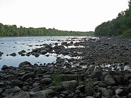
Ayers Island is an island in the Penobscot River in Penobscot County, Maine, near the town of Orono. It was named for one of the original settlers of Orono, Joshua Ayers [Eayres], who constructed a sawmill on the island beginning around 1774.

Searsport is an incorporated town and deep water seaport located at the confluence of the Penobscot River estuary and the Penobscot Bay immediately SE of Sears Island and Cape Jellison in Waldo County, Maine, United States. The population was 2,615 at the 2010 census. Searsport includes the village of North Searsport. The town is known as "the home of the famous sea captains" and the "Antique Capital of Maine".