Marysville Cotton Mill

Last updated

Marysville Place
Marysville Place, New Brunswick (cropped).jpg
Marysville Cotton Mill
Former namesMarysville Cotton Mill
General information
Type Cotton mill
Town or city Marysville, New Brunswick
Country Canada
Coordinates 45°58′42″N66°35′20″W / 45.97833°N 66.58889°W / 45.97833; -66.58889
Construction started1883 (1883)
Completed1885 (1885)
Owner Government of New Brunswick
Design and construction
Engineer Lockwood, Greene & Company
Main contractor Albert H. Kelsey

The Marysville Cotton Mill, now known as Marysville Place, is an industrial building in Marysville, New Brunswick, that is a National Historic Site of Canada. It was built by Alexander Gibson in the mid 1880s as he expanded his industrial operations into textile manufacturing at the company town he had established.

Contents

Since 1986, it has been used by the Government of New Brunswick as an office building and houses the Marysville Data Centre, a data centre used by government departments.

Background

Alexander Gibson established the cotton mill and the company town of Marysville. Alexander Gibson painting by Edward Sharpe.jpg
Alexander Gibson established the cotton mill and the company town of Marysville.

Alexander Gibson moved to what is now Marysville from Lepreau, Charlotte County in late 1862. [1] For £7,300, he purchased a property that included a gristmill, a blacksmith shop, a general store, sawmills, a farm, "a number of houses well suited for workmen", and a 7,000-acre (28,000,000 m2) of woodland. [1] The sawmill operated on the Nashwaak River, on which he had acquired the rights to float logs and rafts to its mouth at the Saint John River. [1]

The flow of water on the river was controlled by dams Gibson had built, ensuring he could transport logs along it throughout the year. [2] When the government offered a grant of 10,000 acres (40,000,000 m2) per 1 mile (1.6 km) of railway track built in the province, Gibson funded the construction of a narrow-gauge railway line to Chatham, for which he received a total grant of 1,647,000 acres (6,670 km2). [2] [3] He sold the railway for $800,000. [2]

His new property had poor sanitation, with the "buildings filthy" and typhoid fever endemic. [1] He had the site cleared, then built a model village named Marysville to house the workers and their families [1] with the funds from the railway sale. [2] These were located on the east side of the river near the cotton mill. [2] On the west side of the river were built mansions on hills for Gibson and the managers. [2] A footbridge across the Nashwaak River connected the 24 duplex houses, known as "White Row", to the nearby mills. [1] Gibson also established a brickyard to manufacture bricks, instead of purchasing them from elsewhere, which was used for the cotton mill, the tenement buildings, and other buildings in the town. [2]

Mill

A 1910 postcard depicting the mill on the east bank of the Nashwaak River Cotton Factory, Marysville N.B..jpg
A 1910 postcard depicting the mill on the east bank of the Nashwaak River

The mill's construction began in 1883 and was completed in 1885. [4] Its design was influenced by the mill designs of New England, and used a brick pier foundation. [4] The building was designed by Lockwood, Greene & Company, an engineering firm based in Providence, Rhode Island, and built by contractor Albert H. Kelsey. [1]

Along with the operation in Milltown (now part of St. Stephen), Marysville Cotton Mill was the largest and most isolated of mills in The Maritimes. [5] The company built a church and a school, and operated a company store that deducted its bills and housing rents from employee's pay. [5] Employees were paid once a month, that with the company housing and requisite family labour would "maximize dependence and discourage sudden resignations". [5] Employees were provided land for kitchen gardens and to use as pasture, and received free firewood. [5]

Worker tenements and cotton mill in Marysville, 1927, crop.jpg
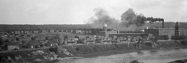
The cotton mill and tenement buildings of Marysville in 1927

The industrious Gibson was well-respected by his employees, which constituted the bulk of the town's population. [6] Workers were awakened in the morning by a steam whistle sounded from the factory, which was also sounded to dismiss them after a ten-hour work-day. [7]

Description

Marysville Cotton Mill is a large, brick building on the east bank of the Nashwaak River, at the intersection of Bridge Street and Rue McGloin. [8] It is in Marysville, now the most northeasterly suburb of Fredericton, with which it was amalgamated in 1973. [2] Each storey of the building has a row of identical multi-pane mullion windows. [4]

The four storey structure is 418 feet (127 m) long and 100 feet (30 m) wide. [1] It was the first building in Fredericton to have electric lighting, and had a sprinkler system. [1] Most of the materials were obtained locally, with the exception of the southern hard pine used for the posts and beams. [1]

National Historic Site

The cotton mill was designated a National Historic Site of Canada on 16 June 1986. [4] The neighbourhood of Marysville was declared a national historic district on 20 November 1993, [9] and on 8 June 2007, Alexander Gibson was designated a Person of National Historic Significance. [10] The railway line was converted into a hiking trail. [4]

Use

The mill manufactured textiles until its closing in the 1970s. [4] In 1985, the Government of New Brunswick undertook a project to restore the building, [8] and when complete its first tenant became the Department of Tourism, Recreation and Heritage. [11]

Today, the Government of New Brunswick uses it as an office building, and it is known as Marysville Place. [2] It was used as the site of the Marysville Data Centre up until 2016, a data centre used by a number of the government's departments, among them the Department of Finance, Department of Health, Department of Justice and Attorney General, Department of Public Safety, and Department of Social Development. It has since been repurposed as an office building for several government departments. [12]

Notes

Related Research Articles

<span class="mw-page-title-main">Fredericton</span> Capital city of New Brunswick, Canada

Fredericton is the capital city of the Canadian province of New Brunswick. The city is situated in the west-central portion of the province along the Saint John River, also known by its Indigenous name of Wolastoq, which flows west to east as it bisects the city. The river is the dominant natural feature of the area. One of the main urban centres in New Brunswick, the city had a population of 63,116 and a metropolitan population of 108,610 in the 2021 Canadian Census. It is the third-largest city in the province after Moncton and Saint John.

<span class="mw-page-title-main">St. Stephen, New Brunswick</span> Town in New Brunswick, Canada

St. Stephen is a Canadian town in Charlotte County, New Brunswick, situated on the east bank of the St. Croix River around the intersection of New Brunswick Route 170 and the southern terminus of New Brunswick Route 3. The St. Croix River marks a section of the Canada–United States border, forming a natural border between Calais, Maine and St. Stephen. U.S. Route 1 parallels the St. Croix river for a few miles, and is accessed from St. Stephen by three cross-border bridges.

<span class="mw-page-title-main">Woodstock, New Brunswick</span> Town on the Saint John River, western New Brunswick, Canada

Woodstock is a town in Carleton County, New Brunswick, Canada on the Saint John River, 103 km upriver from Fredericton at the mouth of the Meduxnekeag River. It is near the Canada–United States border and Houlton, Maine and the intersection of Interstate 95 and the Trans-Canada Highway making it a transportation hub. It is also a service centre for the potato industry and for more than 26,000 people in the nearby communities of Hartland, Florenceville-Bristol, Centreville, Bath and Lakeland Ridges for shopping, employment and entertainment.

<span class="mw-page-title-main">Nashwaak River</span> River in New Brunswick, Canada

The Nashwaak River, located in west-central New Brunswick, Canada, is a tributary of the Saint John River. It is 113 kilometres long. The river rises from Nashwaak Lake and flows south and east through uninhabited land and rapids to the community of Nashwaak. From Nashwaak, the Nashwaak flows southeast to Nashwaak Bridge and Taymouth, then south the through several rural communities such as Durham Bridge, the historic town of Nashwaak Village and Penniac before it reaches the town of Marysville. It flows into the Saint John River opposite downtown Fredericton.

The New Brunswick Railway Company Limited (NBR) is currently a Canadian non-operating railway and land holding company headquartered in Saint John, New Brunswick that is part of Irving Transportation Services, a division within the J.D. Irving Limited (JDI) industrial conglomerate. It is not to be confused with another JDI company, New Brunswick Southern Railway (NBSR), established in 1995, which is an operational railway and considered a sister company of the NBR.

The history of Fredericton stretches from prehistory to the modern day. Fredericton, New Brunswick was first inhabited by the Mi'kmaq and Maliseet peoples. European settlement of the area began with the construction of Fort Nashwaak by the French in 1692. In 1783, the United Empire Loyalists settled Ste. Anne's Point, and in the next year, renamed the settlement Frederick's Town. The name was later shorted to Fredericton in April 1785.

<span class="mw-page-title-main">Marysville, New Brunswick</span> Human settlement in Fredericton, New Brunswick, Canada

Marysville is a suburb of Fredericton, New Brunswick, Canada. It is northeast of the city on the Nashwaak River about 5 kilometres (3.1 mi) north of its confluence with the Saint John River.

<span class="mw-page-title-main">Canada Eastern Railway</span>

The Canada Eastern Railway, originally known as the Northern and Western Railway, was a railway line operating in New Brunswick, Canada, running from Loggieville, to Devon. The line linked various communities along the Nashwaak and Southwest Miramichi River valleys.

<span class="mw-page-title-main">Alexander Gibson (industrialist)</span>

Alexander "Boss" Gibson was a Canadian industrialist in New Brunswick, Canada. His business interests included sawmills, railways, and a cotton mill. He founded the company town of Marysville, New Brunswick.

<span class="mw-page-title-main">Amoskeag Manufacturing Company</span>

The Amoskeag Manufacturing Company was a textile manufacturer which founded Manchester, New Hampshire, United States. From modest beginnings it grew throughout the 19th century into the largest cotton textile plant in the world. At its peak, Amoskeag had 17,000 employees and around 30 buildings.

Nashwaaksis is a neighbourhood and former village in the city of Fredericton, New Brunswick; it is located on the north bank of the Saint John River and at the mouth of the Nashwaaksis Stream, which should not be confused with the larger Nashwaak River nearby. The word Nashwaaksis is corrupted from the Maliseet word for the area, Nesuwahkik, with the "-sis" appendage meaning "little Nashwaak".

<span class="mw-page-title-main">Fredericton Railway Bridge</span> Bridge in Fredericton, New Brunswick, Canada

The Fredericton Railway Bridge is a former railway bridge in Fredericton, New Brunswick, Canada now used to carry pedestrians and cyclists.

<span class="mw-page-title-main">Douglas Parish, New Brunswick</span> Parish in New Brunswick, Canada

Douglas is a civil parish in York County, New Brunswick, Canada.

<span class="mw-page-title-main">Saint Marys Parish, New Brunswick</span> Parish in New Brunswick, Canada

Saint Marys is a civil parish in York County, New Brunswick, Canada.

<span class="mw-page-title-main">Stanley Parish, New Brunswick</span> Parish in New Brunswick, Canada

Stanley is a civil parish in York County, New Brunswick, Canada.

<span class="mw-page-title-main">Fort Nashwaak</span>

Fort Nashwaak was the capital of Acadia and is now a National Historic Site of Canada in present-day Fredericton, New Brunswick, Canada. It was located strategically up the Saint John River and close to the native village of Fort Meductic for military purposes.

Cotton Factory is an historic industrial complex formerly known as The Imperial Cotton Company Limited in the industrial north end of Hamilton, Canada. The complex has been renamed the Cotton Factory and is repurposed for small manufacturing and office space for creative professionals.

<span class="mw-page-title-main">Amos D. Lockwood</span>

Amos DeForest Lockwood (1811–1884) was an American manufacturer and engineer based in Providence, Rhode Island. He was self-trained as a mechanical engineer, and gradually expanded his scope to all areas of textile mill construction. He was a cofounder, in 1882, of Lockwood, Greene & Company, which would become one of the largest engineering firms in the United States in the twentieth century.

<span class="mw-page-title-main">Fort Andross</span> Site of colonial forts & cotton mills, Brunswick Maine

Fort Andross, also known as Fort George and Cabot Mill, originally was a historic trading post and garrison built by the colonial British Empire to fortify against the Wabanaki Native Americans who were aligned with France during King William's War (1688–1697). It was adjacent to Brunswick Falls on the Androscoggin River in Brunswick, Maine. In the 19th century, the location of the fort has been used for several cotton mills including the Cabot Manufacturing Company. In 1986, the mills were transformed into office and retail space and renamed Fort Andross.

References

Further reading