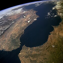
The Strait of Gibraltar is an important naval choke point, as entry to the Mediterranean Sea can be blocked there by a small number of vessels.
In military strategy, a choke point (or chokepoint), or sometimes bottleneck, is a geographical feature on land such as a valley, defile, isthmus or bridge, or maritime passage through a critical waterway such as a strait, which an armed force is forced to pass through in order to reach its objective, sometimes on a substantially narrowed front and therefore greatly decreasing its combat effectiveness by making it harder to bring superior numbers to bear. A choke point can allow a numerically inferior defending force to use the terrain as a force multiplier to thwart or ambush a much larger opponent, as the attacker cannot advance any further without first securing passage through the choke point.
The Fulda Gap was seen as one of the potentially decisive bottleneck battlegrounds of the Cold War in Germany.
Royal Navy choke points
From the 18th to the early 20th centuries, the sheer size of the United Kingdom'sRoyal Navy meant it had control over much of the world's oceans and seas. Choke points were of huge importance to the British Empire, which often used them to control trade in British colonies and, to a lesser extent, for defense. Choke points have also been a source of tension, notably during the Suez Crisis. The Royal Navy still deems its choke points as strategically vital. Indeed, the importance of choke points was first recognised by British Admiral John Fisher.[1]
The choke points still have significant strategic importance for the Royal Navy. The GIUK gap is particularly important to the Royal Navy, as any attempt by northern European forces to break into the open Atlantic would have to do so through the heavily defended English Channel, which is also the world's busiest shipping lane, or through one of the exits on either side of Iceland. Considering British control over the strategic fortress of Gibraltar at the entrance to the Mediterranean, Spain (northern coast), France (Atlantic coast) and Portugal are the only mainland European nations that have direct access to the Atlantic Ocean in a way that cannot be easily blocked at a choke point by the Royal Navy. The GIUK gap was also a strategically important part of the Cold War, as the Royal Navy were given the responsibility of keeping an eye on Soviet submarines trying to break into the open Atlantic.[citation needed]
Importance
Global energy trade relies heavily on maritime transport, as oil, natural gas, and LNG are primarily shipped by sea. Within this system, maritime chokepoints are critical passages along major shipping routes through which a large share of global energy supplies transits.[2] Their strategic location makes them essential nodes for both maritime traffic and energy security. Disruptions at these chokepoints can quickly affect transport costs, price stability, and the reliability of energy markets. As a result, they also carry strong geopolitical importance and play a central role in shaping policies aimed at ensuring stable, sustainable, and resilient maritime trade over the long term.
The Suez Canal and the Sumed pipeline carry 4.5 million barrels (190,000,000USgal; 720,000m3) a day, and the canal carried a total of 7.5% of world trade in 2011.[8] The canal was closed for eight years after the Six-Day War in 1967. In many instances, alternate routes are nonexistent or impractical. For example, an alternate to the Suez/Sumed route required an additional 6,000 miles (9,700km) around Cape of Good Hope.[9] The Royal Navy also still deems its choke points to the Atlantic as strategically important.
Threats to the Strait of Hormuz
The Strait of Hormuz, connecting the Persian Gulf and Arabian Sea, is one of the world's most strategically important maritime choke points. The Islamic Republic of Iran is one of the largest security threats in the Strait of Hormuz and remains an essential factor in global energy security, due to the high volume of oil and natural gas passing through the narrow openings on a daily basis. The sovereignty of The Islamic Republic of Iran extends, beyond its land territory, internal waters and its islands in the Persian Gulf, to the Strait of Hormuz and the Oman Sea.[10]Iran has used its sovereignty to threaten to close down the Strait of Hormuz multiple times, due to sanctions imposed on the country.[11][12] This poses serious threats to the global oil market, with the Strait of Hormuz as a key location. Iran's capabilities are found in the country's anti-access/area denial capabilities including small attack craft equipped with machine guns, multiple-launch rockets, anti-ship missiles and torpedoes.[13][14][15]Naval mining has also been used as a strategy to threaten the security of the Strait of Hormuz.[16][17] Lastly, the many naval exercises and unconventional methods used by the Islamic Republic of Iran Navy, is a display of capability and shows readiness to take action in the choke point.[18][19][20] The strategic value of maritime choke points such as the Strait of Hormuz means that the threats to the choke point influence sharp rises in oil prices.[21] The several attacks which have occurred over the last decade against oil facilities and tankers in or near the Strait of Hormuz, has had a large impact on the oil industry. From the perspective of security studies, Iran is an important player in the international oil economy.
↑Henseler, S. P. (2018). "Left of Splash" Legal Issues Related to the Use of Force to Counter Mining in the Strait of Hormuz. In: Schildknecht, J., Dickey, R., Fink, M. & Ferris, L. (eds.) Operational Law in International Straits and Current Maritime Security Challenges. Springer.
↑Ramazani, R. K. (2013). Independence without Freedom: Iran's Foreign Policy. University of Virginia Press. JSTORj.ctt6wrj9g.
↑Pham, J. P. (2010). "Iran's Threat to the Strait of Hormuz: A Realist Assessment". American Foreign Policy Interests. 32 (2): 64–74. doi:10.1080/10803921003697542. S2CID154650063.
↑Hicks, K. H. & Dalton, M. G. 2017. Deterring Iran after the Nuclear Deal, Rowman & Littlefield.
↑Yadlin, A.; Guazansky, Y. (2012). "The Strait of Hormuz: Assessing and Neutralizing the Threat". Strategic Assessment. 14.
This page is based on this Wikipedia article Text is available under the CC BY-SA 4.0 license; additional terms may apply. Images, videos and audio are available under their respective licenses.