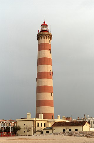
A lighthouse is a tower, building, or other type of physical structure designed to emit light from a system of lamps and lenses and to serve as a beacon for navigational aid, for maritime pilots at sea or on inland waterways.

Longships Lighthouse is an active 19th-century lighthouse about 1.25 mi (2.0 km) off the coast of Land's End in Cornwall, England. It is the second lighthouse to be built on Carn Bras, the highest of the Longships islets which rises 39 feet (12 m) above high water level. In 1988 the lighthouse was automated, and the keepers withdrawn. It is now remotely monitored from the Trinity House Operations & Planning Centre in Harwich, Essex.

Marblehead Lighthouse in Marblehead, Ohio, United States, is the oldest lighthouse in continuous operation on the American side of the Great Lakes. It has guided sailors safely along the rocky shores of Marblehead Peninsula since 1822, and is an active aid to navigation.

Hurst Point Lighthouse is located at Hurst Point in the English county of Hampshire, and guides vessels through the western approaches to the Solent.
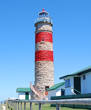
Cape Moreton Light, also listed as North Point Range Rear Light, is a heritage-listed active lighthouse located on Cape Moreton, a rocky headland located at the north eastern tip of Moreton Island, a large sand island on the eastern side of Moreton Bay, on the coast of South East Queensland, Australia. It marks the northern entrance to Moreton Bay and Brisbane and also serves as the rear light for the North Point Range. With its two distinctive red bands, it also serves as a daymark. It is the oldest lighthouse in Queensland, and the only one to be built by the New South Wales Government before the separation of Queensland, which took place in 1859. It is also the only lighthouse in Queensland to be built of stone.

Dent Island Light is an active lighthouse on Dent Island, a small island off the coast of Queensland, Australia, part of the Whitsunday Group of the Whitsunday Islands. Located on the southwest tip of the island, the light guides ships navigating the Whitsunday Passage, between Whitsunday Island and the islands to the west, and marks the Dent Island Passage.

Double Island Point Light is an active lighthouse located at the summit of Double Island Point, a coastal headland within the Cooloola section of the Great Sandy National Park. It is located at the southern end of Wide Bay, 70 kilometres (43 mi) north of Noosa Heads, Queensland, Australia.
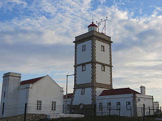
The Lighthouse of Cabo Carvoeiro is an active lighthouse in the civil parish of Peniche, municipality of the same name, in the Portuguese district of Leiria.
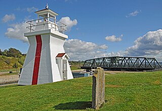
Balache Point Lighthouse also known as Balache Point Range Rear Lighthouse is an active Canadian lighthouse located next to the Canso Canal, near Port Hastings, Inverness County, Nova Scotia. The salt shaker style light, which sits on a small hillock on the Cape Breton side of the canal, is the second lighthouse to be built on the site.
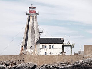
The Gannet Rock Lighthouse is a Canadian lighthouse located on a rocky islet 8 miles (13 km) south of Grand Manan in the Bay of Fundy. It was first lit in 1831 and was staffed until 1996. It was solarized in 2002 and remains operational in 2023. It was declared "surplus to requirements" by the Canadian Coast Guard in 2010 and is no longer being maintained.
Albardão Lighthouse is an active lighthouse located on a sandy strip known as Praia do Cassino, in the municipality of Santa Vitória do Palmar, Brazil on the South Atlantic Ocean; the lighthouse is one of the southernmost Brazilian lights.
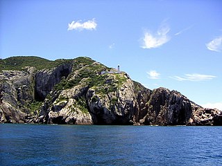
Cabo Frio Lighthouse is an active lighthouse located on the southern point of the Ilha do Cabo Frio, called Focinho do Cabo, in the municipality of Arraial do Cabo, Brazil.
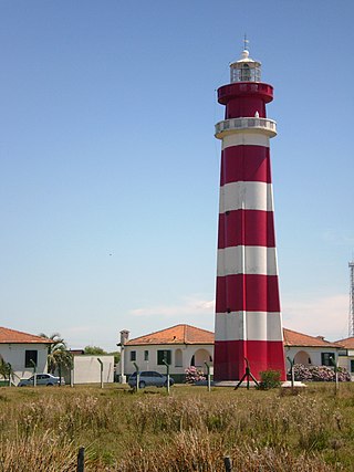
Chuí Lighthouse is an active lighthouse in Barra do Chuí, at the mouth of Chuí Stream, just 1 kilometre (0.62 mi) from the Uruguayan border; the lighthouse is the southernmost of all the Brazilian lights.
Ilha da Moela Lighthouse is an active lighthouse on the namesake island 1.84 kilometres (1.14 mi) from Ponta do Munduba at the entrance of Santos Bay, Brazil. Ilha da Moela Lighthouse is the oldest lighthouse on the State of São Paulo coast and the entire island is a Brazilian Navy base.
Ilha de Santana Lighthouse is an active lighthouse on the namesake island located at the east entrance of the Baía de São Marcos, Maranhão, Brazil

Ilha Rasa Lighthouse is an active lighthouse on the namesake island located 11 kilometres (6.8 mi) from Guanabara Bay, Rio de Janeiro, Brazil.

Murano Lighthouse is an active lighthouse located in the south east part of the island of Murano in the Venetian Lagoon on the Adriatic Sea.
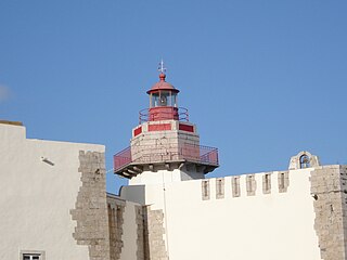
The Outão Lighthouse is located in the coastal Fort of Santiago do Outão, on the right bank of the narrow estuary of the River Sado, to the west of Setúbal in Portugal.

The Inisheer, Inis Oírr or Fardurris Point Lighthouse, is an active 19th century lighthouse located on the island of Inisheer, the smallest of the Aran Islands, in County Galway, Ireland. It marks the south-eastern entrance to Galway bay and the port of Galway known as the South Sound, with a red sector of the light marking the Finnis Rock. The Eeragh Lighthouse which marks the North Sound entrance to the bay on the north-western side of the islands, was also constructed at the same time. Inisheer and Eeragh both became operational in 1857.

The St. Andrews North Point Lighthouse is an active lighthouse in St. Andrews, New Brunswick on the southern tip of the peninsula in the Passamaquoddy Bay; it is commonly known as Pendlebury Lighthouse from the name of the family who took care of it.


