The Canadian Coast Guard is the coast guard of Canada. Formed in 1962, the coast guard is tasked with marine search and rescue (SAR), communication, navigation, and transportation issues in Canadian waters, such as navigation aids and icebreaking, marine pollution response, and support for other Canadian government initiatives. The coast guard operates 119 vessels of varying sizes and 23 helicopters, along with a variety of smaller craft. The CCG is headquartered in Ottawa, Ontario, and is a special operating agency within Fisheries and Oceans Canada.

Race Rocks Light is one of the first two lighthouses that were built on the west coast of Canada, financed by the British Government and illuminated in 1860. It is the only lighthouse on that coast built of rock, (granite) purportedly quarried in Scotland, and topped with sandstone quarried on Gabriola Island. The Islands of Race Rocks are located just off the southern tip of Vancouver Island, about 16 km (10 mi) southwest of Victoria, British Columbia.

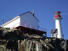
Cape Beale Lightstation is an active manned lighthouse on Vancouver Island in British Columbia., Canada.

Pachena Point Lighthouse is located on Vancouver Island, 13 kilometres (8.1 mi) south of Bamfield, British Columbia, in Pacific Rim National Park. The octagonal wooden tower is maintained by the Canadian Coast Guard who employ lighthouse keepers at the station.

A lighthouse keeper or lightkeeper is a person responsible for tending and caring for a lighthouse, particularly the light and lens in the days when oil lamps and clockwork mechanisms were used. Lighthouse keepers were sometimes referred to as "wickies" because of their job trimming the wicks.
The Langara Point Lighthouse is a manned lighthouse located atop a scenic bluff on the northwest corner of Langara Island. It is one of only two lighthouses in Haida Gwaii – the other being at Cape St. James, at the southern tip of the islands. Both were built in 1913.

Fisgard Lighthouse National Historic Site, on Fisgard Island at the mouth of Esquimalt Harbour in Colwood, British Columbia, is the site of Fisgard Lighthouse, the first lighthouse on the west coast of Canada.

Sheringham Point Lighthouse is located on Vancouver Island, British Columbia, near the community of Shirley. Built in 1912 following the fatal wreck of the SS Valencia six years earlier, it is still used for navigation. The point was named for William L. Sheringham who took part in various naval surveys although not in this area.

Boat Bluff Lighthouse is located near Klemtu on the scenic south end of Sarah Island in Tolmie Channel on the Inside Passage of British Columbia. The lighthouse was established in 1907. The skeleton tower is 24 feet high giving it a focal plane 38 feet above sea level. The station is still staffed by resident keepers.

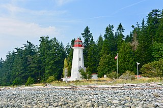
Carmanah Point Light Station is a lighthouse on the southwest coast of Vancouver Island at the entrance from the Pacific Ocean to the Strait of Juan de Fuca.

The Ballenas Island Light is an operational lighthouse built in 1900 but moved to its current location in 1912, located on West Ballenas Island, Canada. It is a white, octagonal concrete tower with a red lantern 27 metres (89 ft) in height. The lighthouse is not open to the public as it is located on a privately owned island.

Entrance Island is a small rocky island in the Strait of Georgia located 841 metres (2,759 ft) due north of Gabriola Island. Marine mammals such as harbour seals and Steller's sea lions use the island as a haul-out.

Low Point Lighthouse is an historic Canadian lighthouse marking the eastern entrance to Sydney Harbour at New Victoria, Nova Scotia, near New Waterford, Nova Scotia. This is one of the earliest and most important light stations of Nova Scotia, one of the first dozen beacons in Nova Scotia to be lit to guide mariners, a classic red-and-white lighthouse still operated by the Canadian Coast Guard.

The major Trial Island is home to the Trial Islands Lighthouse which is operated by the Canadian Coast Guard, and continues to be staffed by two full-time lightkeepers. The current lighthouse was erected in 1970 to replace the original lighthouse that was constructed in 1906. The fourth order Fresnel lens from 1906 was used until it was replaced in 1970. That original lens is now on display courtesy of the Maritime Museum of British Columbia in Bastion Square in Downtown Victoria.

Triple Island Lighthouse is a large, manned light station on Triple Island. Built in 1920 after four years of construction, the concrete station features a 21.9 metres (72 ft) tower attached to a rectangular concrete structure that houses the keepers' quarters and machinery. A Triple Island helipad occupies much of the remainder of the islet. Canadian Coast Guard personnel man the station on a 28-day rotation. The station was designated a National Historic Site of Canada in 1974.

The Ile Parisienne Light was built in 1911 on the southern tip of remote Ile Parisienne in the middle of Whitefish Bay on Lake Superior on a major shipping lane for ingress/egress to the Soo Locks. It is now a well-known landmark to shipping traffic and pleasure craft. The light is automated and remains seasonally active.

Caribou Island Lighthouse sits on the uninhabited Caribou Island in the eastern end of Lake Superior, 22 miles (35 km) south of Michipicoten Island. It lies entirely within the territorial waters of Canada although only about three miles from the international border between Canada and the United States. It is approximately 3 miles (4.8 km) long and approximately 1 mile (1.6 km) wide.
Cape Mudge Lighthouse is located on Quadra Island which is off Campbell River, on the east coast of Vancouver Island, British Columbia, Canada.
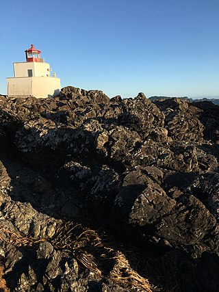
Amphitrite Point Lighthouse is an active lighthouse near Uclulelet on the west coast of Vancouver Island in British Columbia, Canada, named after Amphitrite, the sea goddess and wife of Poseidon in Greek mythology. It is also known for one of the sample pictures in Windows 7.
The British Columbia Shore Station Oceanographic Program is a sea surface temperature and salinity monitoring program on the Canadian coast of the northeast Pacific Ocean. The program is administered by Fisheries and Oceans Canada, and regroups 12 lighthouse stations in British Columbia. Most lighthouses are staffed by the Department of Fisheries and Oceans, but some have independent contractors instead.