Cape Spear is a headland located on the Avalon Peninsula of Newfoundland near St. John's in the Canadian province of Newfoundland and Labrador. At a longitude of 52°37' W, it is the easternmost point in Canada and North America, excluding Greenland.

Cape Race is a point of land located at the southeastern tip of the Avalon Peninsula on the island of Newfoundland, in Newfoundland and Labrador, Canada. Its name is thought to come from the original Portuguese name for this cape, "Raso", meaning flat or low-lying. The Cape appeared on early sixteenth century maps as Cabo Raso and its name may derive from a cape of the same name at the mouth of the Tagus River in Portugal. The cape was the location of the Cape Race LORAN-C transmitter until the system was decommissioned in 2010. It is also home to the Cape Race Lighthouse, notable for having received the distress call from the RMS Titanic.
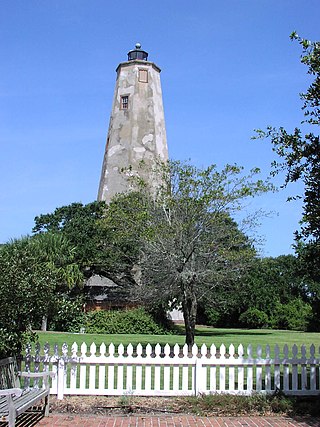
Bald Head Lighthouse, known as Old Baldy, is the oldest lighthouse still standing in North Carolina. It is the second of three lighthouses that have been built on Bald Head Island since the 18th century to help guide ships past the dangerous shoals at the mouth of the Cape Fear river.
Cape Norman is a barren, limestone headland located at the northernmost point of insular Newfoundland in the Canadian province of Newfoundland and Labrador.
Belle Isle Northeast Light is a 27-metre (89 ft) tall, 12-sided flying buttress lighthouse located on Belle Isle, Newfoundland, which was built in 1905. It is one of three lighthouses on the island and was maintained by the Canadian Government despite the fact that Newfoundland did not join Confederation until 1949. It was designed by William P. Anderson as one in a series of nine buttressed lighthouses built in Canada around 1910.

Alcatraz Island Lighthouse is a lighthouse—the first one built on the U.S. West Coast—located on Alcatraz Island in California's San Francisco Bay. It is located at the southern end of the island near the entrance to the prison. The first light house on the island was completed in 1854, and served the bay during its time as a Citadel and military prison. It was replaced by a taller concrete tower built in 1909 to the south of the original one which was demolished after it was damaged due to earthquake in 1906. The automation of the lighthouse with a modern beacon took place in 1963, the year Alcatraz closed as the Alcatraz Federal Penitentiary. It is the oldest light station on the island with a modern beacon and is part of the museum on the island. Although when viewed from afar it easily looks the tallest structure on Alcatraz, it is actually shorter than the Alcatraz Water Tower, but as it lies on higher ground it looks much taller.

Cape Mendocino Light was a navigation light at Cape Mendocino, California. The former lighthouse was relocated to Shelter Cove near Point Delgada, California in 1998, and the historic Fresnel lens to Ferndale, California, in 1948. An automated beacon operated for a number of years but was removed in May 2013.

Cape Anguille is a headland and the westernmost point in Newfoundland, reaching into the Gulf of Saint Lawrence. It is the southern edge of St. George's Bay. Its name is derived from the French word anguille, which means eel. Close to the cape is the community of Cape Anguille.

The Cove Island Light, at Gig Point on the island, is located in Fathom Five National Marine Park, but is not part of the Park. It is situated on the Bruce Peninsula, Ontario Canada. It has been a navigational aid in the narrow channel between Lake Huron and Georgian Bay since 30 October 1858. It was the first of six stone Imperial Towers to be completed; all were illuminated by 1859. Most other lighthouses of the era were built of brick, wood, iron or concrete.

Seguin Light is a lighthouse on Seguin Island, in the Gulf of Maine south of the mouth of the Kennebec River, Maine. Established in 1795, it is the second-oldest of Maine's coastal lighthouses, and the only lighthouse in the state housing a first-order Fresnel lens. With its light at 180 feet (55 m) above mean sea-level, the present tower, built in 1857, is its highest of the state's lighthouses. Automated in 1985, the buildings of the light station are now operated as a museum property by a non-profit organization, and are seasonally open to the public via scheduled ferry from Popham Beach in Phippsburg. The light was listed on the National Register of Historic Places as Seguin Island Light Station in 1977.
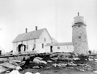
Whitehead Light is a lighthouse on Whitehead Island, on Muscle Ridge Channel, in the southwestern entrance to Penobscot Bay, Maine. It is in the town of St.George. Established in 1804, it is one of Maine's oldest light stations, with its present tower built in 1852 to a design attributed to Alexander Parris. It was listed on the National Register of Historic Places as Whitehead Light Station on March 14, 1988. The property is now owned by not for profit Pine Island Camp. Whitehead light station offers to the public various stays at the light station from getaway weekends to learning retreats and renting the station as a vacation home. The light itself remains an active aid to navigation, maintained by the United States Coast Guard.
The history of lighthouses in Canada dates back to 1734.
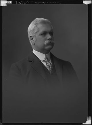
Colonel William Patrick Anderson (1851–1927) was a Canadian civil engineer. He was Superintendent of Lighthouses for almost 40 years, and was responsible for many of the more notable lighthouses in Canada.

Cape Bonavista Light is a lighthouse located on Cape Bonavista, Newfoundland. The lighthouse, which operated from 1843 until 1962, is now a provincial museum, containing an exhibition about life in a lighthouse during the 1870s.
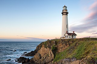
Pigeon Point Light Station or Pigeon Point Lighthouse is a lighthouse built in 1871 to guide ships on the Pacific coast of California. It is the tallest lighthouse on the West Coast of the United States. It is still an active Coast Guard aid to navigation. Pigeon Point Light Station is located on the coastal highway, 5 miles (8 km) south of Pescadero, California, between Santa Cruz and San Francisco. The 115-foot (35 m), white masonry tower, resembles the typical New England structure.
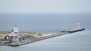
The Grand Marais Harbor of Refuge Inner and Outer Lights are a pair of lighthouses located on the west pier at the entry to Grand Marais Harbor of Refuge, in Grand Marais, Michigan. They were listed on the National Register of Historic Places in 2012.

Cape Race Lighthouse is an active lighthouse located at Cape Race on the Avalon Peninsula, Newfoundland. The light's characteristic is a single white flash every 7.5 seconds; additionally, a foghorn may sound a signal of two blasts every 60 seconds. It is located on one of Canada's busiest shipping lanes. The lighthouse is also a tourist attraction.

The Point Amour Lighthouse is a lighthouse located on Point Amour in southern Labrador, Canada. It is not far from L'Anse Amour, and was completed in 1857. It is the tallest lighthouse in Atlantic Canada, and the second tallest one in all of Canada, reaching a height of 109 feet (33m).

Point Riche Lighthouse, located in Port au Choix, Newfoundland in Canada's Newfoundland and Labrador province, is a "pepperpot" lighthouse that was built in 1892 and is still active. The white wooden tower is octagonal pyramidal in shape, the lantern room is painted red. The structure is 19 metres (62 ft) tall. Its light characteristic is a flash every 5 seconds, emitted at a focal plane height of 29 metres (95 ft). It is maintained by the Port au Choix National Historic Site.
Division No. 1, Subdivision B is an unorganized subdivision on the Avalon Peninsula in Newfoundland and Labrador, Canada. It is in Division 1 and contains the unorganized communities of Iona, Little Barasway, Placentia Junction, Point Verde and Ship Harbour.