
The Gulf of St. Lawrence is the outlet of the North American Great Lakes via the St. Lawrence River into the Atlantic Ocean. The gulf is a semi-enclosed sea, covering an area of about 226,000 square kilometres (87,000 sq mi) and containing about 34,500 cubic kilometres (8,300 cu mi) of water, at an average depth of 152 metres (500 ft).
Division No. 1, Subdivision A is an unorganized subdivision on the Avalon Peninsula in Newfoundland and Labrador, Canada. It is in Division No. 1, and lies between Trinity Bay and Placentia Bay.

Cape Spear is a headland located on the Avalon Peninsula of Newfoundland near St. John's in the Canadian province of Newfoundland and Labrador. At a longitude of 52°37' W, it is the easternmost point in Canada and North America, excluding Greenland.

Cape Race is a point of land located at the southeastern tip of the Avalon Peninsula on the island of Newfoundland, in Newfoundland and Labrador, Canada. Its name is thought to come from the original Portuguese name for this cape, "Raso", meaning flat or low-lying. The Cape appeared on early sixteenth century maps as Cabo Raso and its name may derive from a cape of the same name at the mouth of the Tagus River in Portugal. The cape was the location of the Cape Race LORAN-C transmitter until the system was decommissioned in 2010. It is also home to the Cape Race Lighthouse, notable for having received the distress call from the RMS Titanic.

Trepassey is a small fishing community located in Trepassey Bay on the south eastern corner of the Avalon Peninsula of Newfoundland and Labrador. It was in Trepassey Harbour where the flight of the Friendship took off, with Amelia Earhart on board, the first woman to fly across the Atlantic Ocean.
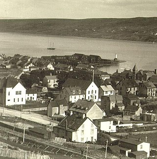
Harbour Grace is a town in Conception Bay on the Avalon Peninsula in the province of Newfoundland and Labrador, Canada. With roots dating back to the 16th century, it is one of the oldest towns in North America.

Cape Ray is a headland located at the southwestern extremity of the island of Newfoundland in the Canadian province of Newfoundland and Labrador.
Cape Norman is a barren, limestone headland located at the northernmost point of insular Newfoundland in the Canadian province of Newfoundland and Labrador.
Cape Bauld is a headland located at the northernmost point of Quirpon Island, an island just northeast of the Great Northern Peninsula of Newfoundland in the Canadian province of Newfoundland and Labrador.
Cape Bonavista is a headland located on the east coast of the island of Newfoundland in the Canadian province of Newfoundland and Labrador. It is located at the northeastern tip of the Bonavista Peninsula, which separates Trinity Bay to the south from Bonavista Bay to the north. The nearby town of Bonavista takes its name from this historic landmark.
Cape Freels is a headland on the island of Newfoundland at the southern tip of the Avalon Peninsula. It is the most southerly point of land on the island of Newfoundland and hence the most southerly of the province of Newfoundland and Labrador. This cape on the Avalon Peninsula is not to be confused with another Cape Freels in Newfoundland, located at the northern extremity of Bonavista Bay. In addition, Cape Freels (Avalon) shares the distinction of being the most southerly point in Newfoundland with nearby Cape Pine, which is situated at the same latitude.

Cape Anguille is a headland and the westernmost point in Newfoundland, reaching into the Gulf of Saint Lawrence. It is the southern edge of St. George's Bay. Its name is derived from the French word anguille, which means eel. Close to the cape is the community of Cape Anguille.

The headland of Cape St. Mary's is located at the southern tip of the south-western arm of the Avalon Peninsula of the island of Newfoundland in the Canadian province of Newfoundland and Labrador.
Old Shop is a local service district and designated place in the Canadian province of Newfoundland and Labrador. It is on the western side of the Dildo Arm, at the southern end of Trinity Bay. It is northwest of South Dildo, across the Dildo Arm from Dildo proper.
Fox Point is a settlement in Newfoundland and Labrador.

Cape Bonavista Light is a lighthouse located on Cape Bonavista, Newfoundland. The lighthouse, which operated from 1843 until 1962, is now a provincial museum, containing an exhibition about life in a lighthouse during the 1870s.

The Cape North Lighthouse is a cylindrical lighthouse tower with a red and white checkerboard pattern that stood at Money Point, near Cape North, Cape Breton from 1908 to 1980. While originally installed at Cape Race, Newfoundland, this tower is most commonly referred to as the Cape North Lighthouse. It now stands landlocked at the Canada Science and Technology Museum in Ottawa, Ontario, Canada.

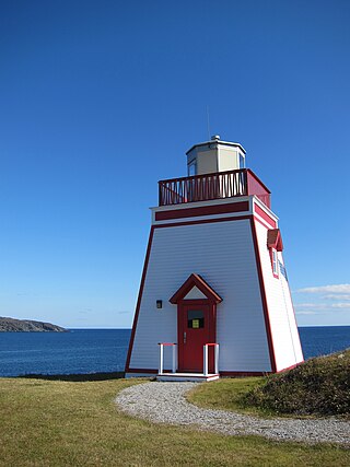
Cape Pine Light was built on Cape Pine, Newfoundland by the British architect and engineer Alexander Gordon in 1851.

