This is a list of lighthouses in the province of Newfoundland and Labrador in Canada.
This is a list of lighthouses in the province of Newfoundland and Labrador in Canada.

Cape Ray is a headland located at the southwestern extremity of the island of Newfoundland in the Canadian province of Newfoundland and Labrador.
Bacalieu Island is an island off Twillingate in Newfoundland. It has a lighthouse. In 1911, it was inhabited by the lighthouse keepers and their families.
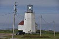
Garnish, a town located on the west coast of the Burin Peninsula, was well known for its lumbering and now for its lobstering operations. Located on Route 213, it is 25 km along route 220 north west of Grand Bank and 18 km along Route 220 east of Marystown. The Way Office was established in 1852 and the first Waymaster was Henry Campe. In 2021, the town had a population of 542.
Belle Isle Northeast Light is a 27-metre (89 ft) tall, 12-sided flying buttress lighthouse located on Belle Isle, Newfoundland, which was built in 1905. It is one of three lighthouses on the island and was maintained by the Canadian Government despite the fact that Newfoundland did not join Confederation until 1949. It was designed by William P. Anderson as one in a series of nine buttressed lighthouses built in Canada around 1910.

Lark Harbour is small fishing community on the western coast of Newfoundland, on the south side of the Bay of Islands, and west of the City of Corner Brook.

Cape Anguille is a headland and the westernmost point in Newfoundland, reaching into the Gulf of Saint Lawrence. It is the southern edge of St. George's Bay. Its name is derived from the French word anguille, which means eel. Close to the cape is the community of Cape Anguille.

King's Cove is a town in the Canadian province of Newfoundland and Labrador. The post office was established in 1851. Its founder was James Aylward from Keels, who was born in Ireland in county Cork in 1690. His direct descendants still live in the community.
Westport is a town in the Canadian province of Newfoundland and Labrador. The town had a population of 185 in 2021, down from 195 in the Canada 2016 Census.

The headland of Cape St. Francis is the outer extremity marking the boundary of Conception Bay on the Avalon Peninsula of the island of Newfoundland in the Canadian province of Newfoundland and Labrador. The International Maritime Organization also designates Cape St. Francis as the southern extremity of the Labrador Sea.

The Headland of Cape Pine is the point of land marking the boundary of Trepassey Bay on the Avalon Peninsula of the island of Newfoundland in the Canadian province of Newfoundland and Labrador.

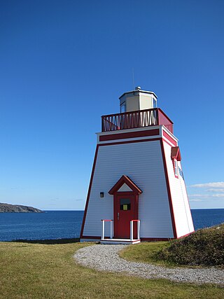
Long Point Lighthouse is an active Canadian lighthouse located outside Crow Head on North Twillingate Island off the northeast coast of Newfoundland. The lighthouse, completed in 1876, attracts thousands of tourists each year and is historic to the town of Twillingate.

Lobster Cove is a fishing village near Rocky Harbour, Newfoundland.
Fox Point is a settlement in Newfoundland and Labrador.

Cape Bonavista Light is a lighthouse located on Cape Bonavista, Newfoundland. The lighthouse, which operated from 1843 until 1962, is now a provincial museum, containing an exhibition about life in a lighthouse during the 1870s.

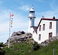
The major Trial Island is home to the Trial Islands Lighthouse which is operated by the Canadian Coast Guard, and continues to be staffed by two full-time lightkeepers. The current lighthouse was erected in 1970 to replace the original lighthouse that was constructed in 1906. The fourth order Fresnel lens from 1906 was used until it was replaced in 1970. That original lens is now on display courtesy of the Maritime Museum of British Columbia in Bastion Square in Downtown Victoria.

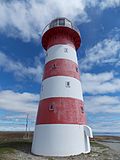
The Point Amour Lighthouse is a lighthouse located on Point Amour in southern Labrador, Canada. It is not far from L'Anse Amour, and was completed in 1857. It is the tallest lighthouse in Atlantic Canada, and the second tallest one in all of Canada, reaching a height of 109 feet (33m).

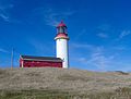
Point Riche Lighthouse, located in Port au Choix, Newfoundland in Canada's Newfoundland and Labrador province, is a "pepperpot" lighthouse that was built in 1892 and is still active. The white wooden tower is octagonal pyramidal in shape, the lantern room is painted red. The structure is 19 metres (62 ft) tall. Its light characteristic is a flash every 5 seconds, emitted at a focal plane height of 29 metres (95 ft). It is maintained by the Port au Choix National Historic Site.

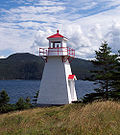
Ferryland Head Light is an active lighthouse on Avalon Peninsula, southeast of the village of Ferryland, Newfoundland and Labrador. It is situated at the end of a long peninsula that juts into the sea.