This article has an unclear citation style .(February 2017) |
This is a list of lighthouses in the province of British Columbia, Canada.
This article has an unclear citation style .(February 2017) |
This is a list of lighthouses in the province of British Columbia, Canada.
| Name | Image and map | Water body | Region | Location | Built | Notes |
|---|---|---|---|---|---|---|
| Active Pass Lighthouse |   | 1885 | ||||
| Addenbroke Island Light Station |  | Fitz Hugh Sound | 100 km north of Port Hardy | Addenbroke Island, on the eastern side of Fitz Hugh Sound. | 1914 | The structure consists of a Fibreglass tower that is 26 ft tall and painted white. The active focal plane is 24 metres above sea level. It flashes white every 5 seconds. This is a staffed light house. There are two keepers in adjacent structures. |
| Amphitrite Point Light |  | Barkley Sound | Barkley Sound, northern entrance | Ucluelet, southern end | 1915 | The building is white with a red lantern. It flashes every 12 seconds and has a focal plane of 15 metres (50 ft). The original structure was destroyed by a tsunami in 1914 and rebuilt in 1915. |
| Ballenas Island Light |  | 1917 | ||||
| Boat Bluff Lighthouse | 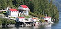 | Hecate Strait | Sarah Passage | 1897 (station established) | This light is located around 5 kilometres north of the village of Klemtu. It is there to mark the northbound entrance to Sarah Passage and is situated on the west side of Sarah Island. The light itself is a tower, square pyramidal in shape and made of steel. The tower is white and the square base is red. This is a staffed light consisting of a number of structures and a weather station. | |
| Brockton Point Lighthouse | 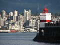 | 1915 | ||||
| Cape Beale Lighthouse |  | Barkley Sound | Pacific Rim National Park Reserve | Pacific Rim National Park Reserve | 1958 | This light is used to mark the southern entrance to Barkley Sound. It is a square pyrimidal tower made of steel. This skeletal structure has a square cylinder in the center. There is a lantern and gallery, both painted red. Three sides have a white, slatted daymark. This light is staffed and consists of a number of buildings, all with red roofs. |
| Cape Mudge Lighthouse |  | 1916 | ||||
| Cape Scott Lighthouse |  | Pacific Ocean | Vancouver Island, northwestern tip | Cape Scott Provincial Park | 1981 | The light is a square skeletal structure. It is made of steel and has a red painted lantern and a gallery. The focal plane is 70 metres (229 feet) and flashes white every 10 seconds. The site consists of a number of red-roofed buildings. |
| Carmanah Point Light Station |  | 1920 | ||||
| Chrome Island Lighthouse |  | 1890 | ||||
| Discovery Island Light |  | 1885 | ||||
| Entrance Island Lighthouse |  | 1970 (circa) | ||||
| Estevan Point |  | 1910 | ||||
| Fisgard Lighthouse |  | 1860 | The oldest lighthouse on the West Coast of Canada. | |||
| Green Island Lighthouse | 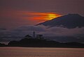 | 1906 (station established) | ||||
| Ivory Island Lightstation |  | 1898 | ||||
| Langara Light | | 1913 | ||||
| Lucy Islands Light |  | 1960 | ||||
| Merry Island Lighthouse | | Halfmoon Bay 49°28′03″N123°54′44″W / 49.467448°N 123.912313°W | 1903 [1] | |||
| Mayne Island Lighthouse |  | |||||
| Nootka Lighthouse | 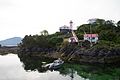 | Nootka Sound | west coast of Vancouver Island | summit of San Rafael Island at entrance to Nootka Sound. | 1910 | Red square skeleton tower. Active focal plane at 30.9 metres. It flashes white 0.2 seconds every 12 seconds. [2] |
| Pachena Point Light |  | 1908 | ||||
| Point Atkinson Lighthouse |  | 1912 | ||||
| Portlock Point Lighthouse | 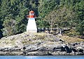 | 1987 | ||||
| Race Rocks Lighthouse | 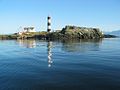 | 1860 | The second oldest lighthouse on the West Coast of Canada. | |||
| Sangster Island Light | | |||||
| Scarlett Point Lighthouse |  | 1905 (station established) | ||||
| Sheringham Point Lighthouse |  | 1912 | ||||
| Trial Islands Lightstation |  | 1906 | ||||
| Triple Island Lightstation |  | Chatham Sound | North Coast Regional District | Brown Passage 25 miles (40 km) W of Prince Rupert | 1920 | A 21.9 metres (72 ft) tower attached to a rectangular concrete structure with a helipad ( IATA : YTI). Designated a National Historic Site of Canada in 1974. [3] |
{{cite web}}: CS1 maint: archived copy as title (link)