Amphitrite Point Light

Last updated

Amphitrite Point Lighthouse
AmphitriteLight2.jpg
Amphitrite Point Light
Location Vancouver Island
British Columbia
Canada
Coordinates 48°55′16.3″N125°32′28.1″W / 48.921194°N 125.541139°W / 48.921194; -125.541139 Coordinates: 48°55′16.3″N125°32′28.1″W / 48.921194°N 125.541139°W / 48.921194; -125.541139
Tower
Constructed1915
Constructionconcrete tower
Automated1988
Height6 metres (20 ft)
Shapetower with balcony and lantern
Markingswhite tower, red lantern
Fog signal (2) 20 s
Light
First litMarch 1915
Focal height15 metres (49 ft)
Range15 nmi (28 km; 17 mi)  OOjs UI icon edit-ltr-progressive.svg
Characteristic Fl W 12 s

Amphitrite Point Lighthouse is an active lighthouse near Uclulelet on the west coast of Vancouver Island in British Columbia, Canada, named after Amphitrite, the sea goddess and wife of Poseidon in Greek mythology. It is also known for one of the sample pictures in Windows 7. [1] [2]

Contents

Geography

The lighthouse can be accessed via the Wild Pacific Trail Amphitrite Point Light on the Wild Pacific Trail.jpg
The lighthouse can be accessed via the Wild Pacific Trail

Amphitrite Point has the only active lighthouse in the Tofino-Ucluelet area accessible by automobile, with the only other local lighthouse being on Lennard Island, viewable only by air or boat. The Amphitrite Point Light is located at the southern end of the Ucluelet Peninsula and the north side of the Barkley Sound, approximately 3 kilometers south of downtown Ucluelet and 40 kilometers south of Tofino, British Columbia. The lighthouse tower is closed to the public but the grounds are open as part of the Lighthouse Loop section of the Wild Pacific Trail. In addition to hiking the trail to view the lighthouse, visitors can park at the end of Coast Guard Road and walk directly to the lighthouse in 2–3 minutes. Amphitrite Point, much like the rest of the Ucluelet Peninsula, is subjected to frequent winter storms and has an oceanic climate (Köppen Cfb) with approximately 3.3 metres (130 inches) of annual rainfall. [3] The next active lighthouse to the north of Amphitrite Point Light is the Lennard Island Lighthouse off of Chesterman Beach; the next active lighthouse to the south is the Cape Beale Lightstation on the south side of Barkley Sound.

History

The first lighthouse at this site was a small wooden tower built in 1906. [4] This lighthouse was destroyed in bad weather in 1914, and the current concrete lighthouse opened in March 1915. [5] Amphitrite Point is exposed to frequent gale-force winds, tidal waves and is also in a tsunami inundation zone, so the current lighthouse (built in 1915) derives its peculiar shape and construction from being designed to withstand strong westerly storms coming off the Pacific Ocean. It was staffed by Canadian Coast Guard lighthouse keepers from 1915 until 1988, when it was automated. [4]

Oceanographic research

The Amphitrite Point Light is one of 12 lighthouses part of the British Columbia Shore Station Oceanographic Program, collecting coastal water temperature and salinity measurements everyday since 1934. [6] Their data show an increase in coastal water temperatures of 0.08 °C per decade. This trend is a result of anthropogenic climate change. [7]

Climate

Climate data for Amphitrite Point Light
MonthJanFebMarAprMayJunJulAugSepOctNovDecYear
Record high °C (°F)18.2
(64.8)
16.8
(62.2)
17.2
(63.0)
19.7
(67.5)
22.4
(72.3)
24.9
(76.8)
25.5
(77.9)
26.6
(79.9)
25.6
(78.1)
20.8
(69.4)
16.6
(61.9)
14.5
(58.1)
26.6
(79.9)
Average high °C (°F)8.3
(46.9)
8.9
(48.0)
10.2
(50.4)
11.6
(52.9)
13.9
(57.0)
15.3
(59.5)
16.8
(62.2)
17.3
(63.1)
16.4
(61.5)
13.3
(55.9)
10.1
(50.2)
8.1
(46.6)
12.5
(54.5)
Daily mean °C (°F)6.1
(43.0)
6.4
(43.5)
7.3
(45.1)
8.6
(47.5)
11.0
(51.8)
12.7
(54.9)
14.2
(57.6)
14.7
(58.5)
13.7
(56.7)
10.7
(51.3)
7.7
(45.9)
5.7
(42.3)
9.9
(49.8)
Average low °C (°F)3.9
(39.0)
3.8
(38.8)
4.5
(40.1)
5.6
(42.1)
8.1
(46.6)
10.2
(50.4)
11.6
(52.9)
12.1
(53.8)
11.0
(51.8)
8.1
(46.6)
5.3
(41.5)
3.3
(37.9)
7.3
(45.1)
Record low °C (°F)−7.3
(18.9)
−12.8
(9.0)
−6.0
(21.2)
−2.1
(28.2)
1.0
(33.8)
5.5
(41.9)
5.2
(41.4)
7.4
(45.3)
5.2
(41.4)
−0.7
(30.7)
−6.9
(19.6)
−7.6
(18.3)
−12.8
(9.0)
Average precipitation mm (inches)462.1
(18.19)
371.2
(14.61)
311.1
(12.25)
262.4
(10.33)
157.1
(6.19)
140.3
(5.52)
71.8
(2.83)
75.3
(2.96)
113.4
(4.46)
339.0
(13.35)
464.2
(18.28)
421.4
(16.59)
3,189.2
(125.56)
Average rainfall mm (inches)458.0
(18.03)
361.4
(14.23)
309.4
(12.18)
262.3
(10.33)
157.1
(6.19)
140.3
(5.52)
71.8
(2.83)
75.3
(2.96)
113.4
(4.46)
339.0
(13.35)
458.5
(18.05)
414.2
(16.31)
3,160.6
(124.43)
Average snowfall cm (inches)4.1
(1.6)
9.1
(3.6)
1.7
(0.7)
0.1
(0.0)
0.0
(0.0)
0.0
(0.0)
0.0
(0.0)
0.0
(0.0)
0.0
(0.0)
0.0
(0.0)
2.4
(0.9)
7.3
(2.9)
24.7
(9.7)
Average precipitation days (≥ 0.2 mm)22.419.620.718.815.614.310.79.612.719.523.822.1209.8
Average rainy days (≥ 0.2 mm)22.019.220.718.815.614.310.79.612.719.523.421.5208.1
Average snowy days (≥ 0.2 cm)1.32.11.10.160.00.00.00.00.00.061.11.77.4
Source: Environment Canada [8]

See also

Related Research Articles

<span class="mw-page-title-main">Pacific Rim National Park Reserve</span> National park reserve in British Columbia, Canada

Pacific Rim National Park Reserve is a 511 km2 (197 sq mi) national park located in British Columbia, Canada, which comprises three separate regions: Long Beach, the Broken Group Islands, and the West Coast Trail. Its the Pacific Coast Mountains, are characterized by rugged coasts and temperate rainforests.

<span class="mw-page-title-main">Race Rocks Light</span> Lighthouse

Race Rocks Light is one of the first two lighthouses that were built on the west coast of Canada, financed by the British Government and illuminated in 1860. It is the only lighthouse on that coast built of rock, (granite) purportedly quarried in Scotland, and topped with sandstone quarried on Gabriola Island. The Islands of Race Rocks are located just off the southern tip of Vancouver Island, about 16 km (10 mi) southwest of Victoria, British Columbia.

<span class="mw-page-title-main">Ucluelet</span> District municipality in British Columbia, Canada

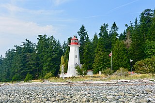
Ucluelet is a district municipality on the Ucluelet Peninsula on the west coast of Vancouver Island in British Columbia, Canada. Ucluelet means "people of the safe harbour" in the indigenous Nuu-chah-nulth (Nootka) language. As of 2021, its population was 2,066, a 20.3% increase from 1,717 in 2016.

<span class="mw-page-title-main">Cape Beale Light</span> Lighthouse

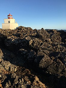
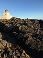
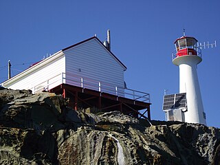
Cape Beale Lightstation is an active manned lighthouse on Vancouver Island in British Columbia., Canada.

The Langara Point Lighthouse is a manned lighthouse located atop a scenic bluff on the northwest corner of Langara Island. It is one of only two lighthouses in Haida Gwaii – the other being at Cape St. James, at the southern tip of the islands. Both were built in 1913.

<span class="mw-page-title-main">Sheringham Point Light</span> Lighthouse

Sheringham Point Lighthouse is located on Vancouver Island, British Columbia, near the community of Shirley. Built in 1912 following the fatal wreck of the SS Valencia six years earlier, it is still used for navigation. The point was named for William L. Sheringham who took part in various naval surveys although not in this area.

<span class="mw-page-title-main">Cape Forchu Lighthouse</span> Lighthouse

The Cape Forchu Lighthouse is located in Cape Forchu, Nova Scotia. The lighthouse is located 11 km from Yarmouth, Nova Scotia.

<span class="mw-page-title-main">Boat Bluff Lighthouse</span> Lighthouse in British Columbia, Canada

Boat Bluff Lighthouse is located near Klemtu on the scenic south end of Sarah Island in Tolmie Channel on the Inside Passage of British Columbia. The lighthouse was established in 1907. The skeleton tower is 24 feet high giving it a focal plane 38 feet above sea level. The station is still staffed by resident keepers.

<span class="mw-page-title-main">Long Beach (British Columbia)</span> Beach in British Columbia

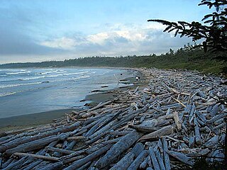
Long Beach is the largest and longest beach in the Pacific Rim National Park Reserve on the west coast of Vancouver Island, British Columbia, Canada. It is on Wickaninnish Bay between Tofino (NW) and Ucluelet (SE) and is adjoined by campgrounds and picnic areas. The Tofino-Ucluelet highway parallels the entirety of the beach. The beach's consistent surf, exposed to the open Pacific Ocean, established it as one of the earliest and most popular surfing locations in British Columbia.

<span class="mw-page-title-main">Tofino</span> District municipality in British Columbia, Canada

Tofino is a town of approximately 2,516 residents on the west coast of Vancouver Island in the Canadian province of British Columbia. The District of Tofino is located at the western terminus of Highway 4 on the tip of the Esowista Peninsula at the southern edge of Clayoquot Sound. It is situated in the traditional territory of the Tla-o-qui-aht First Nations.

<span class="mw-page-title-main">Ivory Island</span>

Ivory Island Lightstation is located 14 miles northwest of Bella Bella on the junction of Seaforth Channel and Milbanke Sound on the Inside Passage of British Columbia.

<span class="mw-page-title-main">Entrance Island (British Columbia)</span> Lighthouse

Entrance Island is a small rocky island in the Strait of Georgia located 841 metres (2,759 ft) due north of Gabriola Island. Marine mammals such as harbour seals and Steller's sea lions use the island as a haul-out.

<span class="mw-page-title-main">Chrome Island Lighthouse</span> Lighthouse in British Columbia, Canada

Chrome Island Lighthouse is a light station established in 1891 that assists traffic in the region of Deep Bay, British Columbia, Denman Island, and Hornby Island. It is currently a manned station, though in recent years the Canadian Coast Guard has considered converting it to fully automated status.

<span class="mw-page-title-main">Trial Islands Lighthouse</span> Heritage-designated lighthouse near Victoria, BC

The major Trial Island is home to the Trial Islands Lighthouse which is operated by the Canadian Coast Guard, and continues to be staffed by two full-time lightkeepers. The current lighthouse was erected in 1970 to replace the original lighthouse that was constructed in 1906. The fourth order Fresnel lens from 1906 was used until it was replaced in 1970. That original lens is now on display courtesy of the Maritime Museum of British Columbia in Bastion Square in Downtown Victoria.

<span class="mw-page-title-main">Triple Island Lightstation</span> Lighthouse

Triple Island Lighthouse is a large, manned light station on Triple Island. Built in 1920 after four years of construction, the concrete station features a 21.9 metres (72 ft) tower attached to a rectangular concrete structure that houses the keepers' quarters and machinery. A Triple Island helipad occupies much of the remainder of the islet. Canadian Coast Guard personnel man the station on a 28-day rotation. The station was designated a National Historic Site of Canada in 1974.

<span class="mw-page-title-main">Cape Mudge Lighthouse</span> Lighthouse

Cape Mudge Lighthouse is located on Quadra Island which is off Campbell River, on the east coast of Vancouver Island, British Columbia, Canada.

Gord Johns is a Canadian businessman and politician. Since 2015, he has served as the New Democrat Member of Parliament for the federal electoral riding of Courtenay—Alberni in the House of Commons of Canada. He previously served as a town councillor for Tofino, British Columbia and founded a number of small businesses.

<span class="mw-page-title-main">Josie Osborne</span> Canadian politician

Josie Osborne is a Canadian politician who was elected to the Legislative Assembly of British Columbia in the 2020 provincial election. She represents the electoral district of Mid Island-Pacific Rim as a member of the British Columbia New Democratic Party. She has served in the cabinet of British Columbia since 2020, currently as Minister of Energy, Mines and Low Carbon Innovation.

The British Columbia Shore Station Oceanographic Program is a sea surface temperature and salinity monitoring program on the Canadian coast of the northeast Pacific Ocean. The program is administered by Fisheries and Oceans Canada, and regroups 12 lighthouse stations in British Columbia. Most lighthouses are staffed by the Department of Fisheries and Oceans, but some have independent contractors instead.

References

  1. Alphin, Tom (6 August 2015). "How my photo of a Lighthouse ended up in Windows 7". Tom Alphin. Retrieved 24 June 2022.
  2. "Guided Help: Shuffle your desktop backgrounds in Windows 7". support.microsoft.com. Retrieved 24 June 2022.
  3. "Canadian Climate Normals 1981-2010 Station Data". Environment Canada . 2017-10-10. Retrieved 2017-12-24.
  4. 1 2 "Amphitrite Point Lighthouse". LighthouseFriends. Retrieved 2017-11-04.
  5. Rowlett, Russ. "Lighthouses of Canada: Southern British Columbia". The Lighthouse Directory. University of North Carolina at Chapel Hill . Retrieved 2017-11-04.
  6. Fisheries and Oceans Canada (2019-03-21). "Data from BC lightstations". www.dfo-mpo.gc.ca. Fisheries and Oceans Canada. Retrieved 2021-02-11.
  7. "Canada's Changing Climate Report (CCCR)". 2019. p. 358. Retrieved 2021-02-10. There is only a 1% possibility that the trend is due to chance
  8. "Amphitrite Point". Canadian Climate Normals 1981–2010 Station Data. Environment Canada. 25 September 2013. Retrieved October 21, 2019.