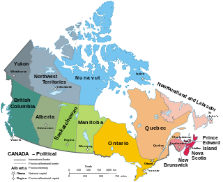
The provinces and territories of Canada are sub-national divisions within the geographical areas of Canada under the jurisdiction of the Canadian Constitution. In the 1867 Canadian Confederation, three provinces of British North America—New Brunswick, Nova Scotia, and the Province of Canada —were united to form a federated colony, becoming a sovereign nation in the next century. Over its history, Canada's international borders have changed several times, and the country has grown from the original four provinces to the current ten provinces and three territories. Together, the provinces and territories make up the world's second-largest country by total area.

Conception Harbour is a town on the Avalon Peninsula in Newfoundland and Labrador, Canada. It is in Division 1 on Conception Bay.

Come By Chance is a town on the isthmus of the Avalon Peninsula in Newfoundland and Labrador, Canada. It is in Division 1 on Placentia Bay.
Division No. 7, Subd. E is an unorganized subdivision in eastern Newfoundland, Newfoundland and Labrador, Canada. It is in Division No. 7 on Bonavista Bay.

Division No. 6, Subd. E is an unorganized subdivision in northeastern Newfoundland, Newfoundland and Labrador, Canada. It is in Division No. 6.

Glenwood is a town in northeastern Newfoundland, Newfoundland and Labrador, Canada. It is in Division No. 6 on Gander Lake.
Norris Arm is a town in north-central Newfoundland, Newfoundland and Labrador, Canada. It is in Division No. 6, on the Bay of Exploits.
Bishop's Falls is a town in the north-central part of the island of Newfoundland in the Canadian province of Newfoundland and Labrador, with a population of 3, 156 at the 2016 census.
Bonavista is a town on the Bonavista Peninsula, Newfoundland in the Canadian province of Newfoundland and Labrador. Unlike many Newfoundland coastal settlements, Bonavista was built on an open plain, not in a steep cove, and thus had room to expand to its current area of 31.5 km2 (12.2 sq mi).

Nunatsiavut is an autonomous area claimed by Inuit in Newfoundland and Labrador, Canada. The settlement area includes territory in Labrador extending to the Quebec border. In 2002, the Labrador Inuit Association submitted a proposal for limited autonomy to the government of Newfoundland and Labrador. The constitution was ratified on December 1, 2005, at which time the Labrador Inuit Association ceased to exist, and the new Government of Nunatsiavut was established, initially being responsible for health, education and cultural affairs. It is also responsible for setting and conducting elections, the first of which was executed in October 2006. An election for the ordinary members of the Nunatsiavut Assembly was held on May 4, 2010. The Nunatsiavut Assembly was dissolved on April 6 in preparation for the election. Its incumbent president is Johannes Lampe who assumed office in 2016.

Channel-Port aux Basques is a town at the extreme southwestern tip of Newfoundland fronting on the western end of the Cabot Strait. A Marine Atlantic ferry terminal is located in the town which is the primary entry point onto the island of Newfoundland and the western terminus of the Newfoundland and Labrador Route 1 in the province. The town was incorporated in 1945 and its population in the 2016 census was 4,067.

The Great Northern Peninsula is the largest and longest peninsula of Newfoundland, Canada, approximately 270 km long and 90 km wide at its widest point and encompassing an area of 17,483 km2. It is defined as that part of Newfoundland from Bonne Bay northwards around Cape Norman and Cape Bauld and thence southwards to the head of White Bay, bounded by the Gulf of St. Lawrence on the west, the Strait of Belle Isle on the north and the Labrador Sea and White Bay on the east.
Division No. 6, Subd. A is an unorganized subdivision in north-central Newfoundland, Newfoundland and Labrador, Canada. It is in Division No. 6. It surrounds the towns of Buchans and Millertown.
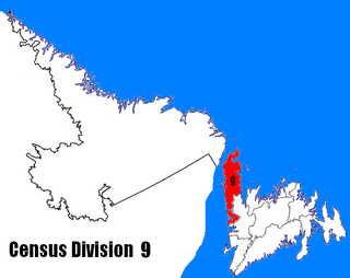
Census Division No. 9 is composed of the area of the province of Newfoundland and Labrador called the Northern Peninsula. It has a land area of 13,527.12 km² and had a population of 15,607 at the 2016 census. The largest community is the town of St. Anthony, near its northern tip, on the Atlantic Ocean coast.
Division No. 4, Subdivision A is an unorganized subdivision on the Southwest coast of the island of Newfoundland in Newfoundland and Labrador, Canada. It is in Division No. 4. According to the 2006 Statistics Canada Census:
Division No. 4, Subd. B is an unorganized subdivision on St. George's Bay on the island of Newfoundland in Newfoundland and Labrador, Canada. It is in Division No. 4. According to the 2016 Statistics Canada Census:
Division No. 4, Subd. D is an unorganized subdivision on the island of Newfoundland in Newfoundland and Labrador, Canada. It is in Division No. 4. According to the 2016 Statistics Canada Census:
Division No. 4, Subd. E is an unorganized subdivision on the Port au Port Peninsula on the island of Newfoundland in Newfoundland and Labrador, Canada. It is in Division No. 4. According to the 2016 Statistics Canada Census:
Mount Pearl is the third-largest settlement and second-largest city in Newfoundland and Labrador, Canada. The city is located southwest of St. John's, on the eastern tip of the Avalon Peninsula on the island of Newfoundland. Mount Pearl is part of the St. John's metropolitan area, the 20th largest metropolitan area in Canada.
This page is based on this
Wikipedia article Text is available under the
CC BY-SA 4.0 license; additional terms may apply.
Images, videos and audio are available under their respective licenses.
