Whitbourne is a town on the Avalon Peninsula in Newfoundland and Labrador, Canada in Division 1.

The Newfoundland Railway was a narrow-gauge railway that operated on the island of Newfoundland from 1898 to 1988. With a total track length of 906 miles (1,458 km), it was the longest 3 ft 6 in narrow-gauge system in North America.
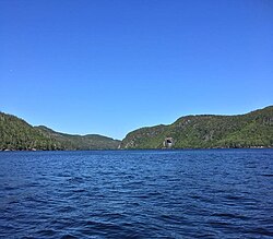
Placentia Bay is a body of water on the southeast coast of Newfoundland, Canada. It is formed by Burin Peninsula on the west and Avalon Peninsula on the east. Fishing grounds in the bay were used by native people long before the first European fishermen arrived in the 16th century. For a time, the French controlled the bay. They built their capital at Placentia on the east coast. The British gained Placentia during the Treaty of Utrecht in 1713. The town and nearby Castle Hill are national historic sites. English settlement followed in the bay and today the main communities are Burin, Marystown, and Placentia.

Placentia is a town located in the Canadian province of Newfoundland and Labrador. It consists of the amalgamated communities of Placentia ("Townside"), Southeast Placentia, Freshwater, Dunville and Jerseyside and also includes the Argentia Industrial Park.

Placentia—St. Mary's is a provincial electoral district for the House of Assembly of Newfoundland and Labrador, Canada. As of 2011, there were 7,361 eligible voters living within the district.

Naval Station Argentia is a former base of the United States Navy that operated from 1941 to 1994. It was established in the community of Argentia in what was then the Dominion of Newfoundland, which later became the tenth Canadian province, Newfoundland and Labrador.
Pilley's Island is a town located on the island of the same name in the Canadian province of Newfoundland and Labrador. It is located in Division No. 8, Newfoundland and Labrador.

Argentia is a Canadian commercial seaport and industrial park located in the Town of Placentia, Newfoundland and Labrador. It is situated on the southwest coast of the Avalon Peninsula and defined by a triangular shaped headland which reaches northward out into Placentia Bay creating a natural harbour 3 km (1.9 mi) in length.

Fox Harbour is a small community on the Avalon Peninsula of Newfoundland. According to Statistics Canada in 2011, the population was 270. It is surrounded by hills. It is located close to Argentia, the site of the Naval Station Argentia. According to some sources, Fox Harbour got its name from tales of foxes that came down from the surrounding hills and ate the drying fish on the flakes. As well, the community was called Little Glocester before it became officially named Fox Harbour.
Dunville is a neighborhood located in the Town of Placentia, in Canada. it was earlier called Northeast or North East Placentia. The name was formed from "Dunphy's Village" a part of Northeast Placentia. It is a community that makes up the north-eastern section of the Town of Placentia. It stretches approximately 8 km along the northern shore of the North-East Arm of Placentia Bay.
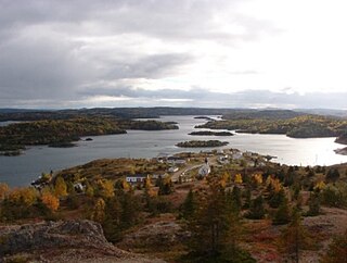
Toslow is a resettled fishing community in Placentia Bay on the island of Newfoundland in the Canadian province of Newfoundland and Labrador. The village was located in a natural harbour called Presque Harbour. According to Howley, the name is believed to be a corruption of the French for silver cup because "the little harbour is cup-like, and the quartz in the rocky cliffs give it a silver-like appearance".
Ship Harbour is a community in Newfoundland and Labrador, Canada located on the eastern shore of Placentia Bay.
Swells Cove was a small community in Newfoundland and Labrador. It is located near Ship Harbour, Placentia Bay, and is accessible from Ship Harbour through "The American Road".
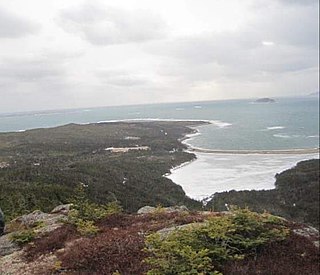
Patrick's Cove-Angels Cove is a local service district and designated place in the Canadian province of Newfoundland and Labrador. It is on the Cape Shore of the Avalon Peninsula. The area was first settled by James Coffey in the early 19th century. Coffey had moved to Newfoundland from County Waterford, Ireland to work at Placentia's Saunders and Sweetman firm. Sweetman's firm had sent some of their employees outward from Placentia to start farms in which to supply Sweetman's with produce. Coffey became the first resident of this community.
Richard T. McGrath was a politician in Newfoundland. He represented Placentia and St. Mary's in the Newfoundland House of Assembly from 1894 to 1897 and from 1900 to 1904 as a Liberal.
William Joseph Walsh was a politician in Newfoundland. In the Newfoundland House of Assembly, he represented Placentia and St. Mary's from 1913 to 1928 as a member of the Newfoundland People's Party and Placentia West from 1932 to 1934 as a member of the United Newfoundland Party.
Division No. 1, Subdivision B is an unorganized subdivision on the Avalon Peninsula in Newfoundland and Labrador, Canada. It is in Division 1 and contains the unorganized communities of Iona, Little Barasway, Placentia Junction, Point Verde and Ship Harbour.

Rose au Rue is an abandoned whaling town in Newfoundland and Labrador, Canada that had a small population of 11 in 1891.
Pays Cove is an abandoned town in Newfoundland and Labrador, Canada that had a peak population of 11 in 1935.
Jemmy's Cove is a tiny abandoned town located near New Harbour, Fortune Bay in Newfoundland and Labrador, Canada that had a peak population of 6 in 1911.