
The Northwest Passage (NWP) is the sea lane between the Atlantic and Pacific oceans through the Arctic Ocean, along the northern coast of North America via waterways through the Canadian Arctic Archipelago. The eastern route along the Arctic coasts of Norway and Siberia is accordingly called the Northeast Passage (NEP). The various islands of the archipelago are separated from one another and from Mainland Canada by a series of Arctic waterways collectively known as the Northwest Passages, Northwestern Passages or the Canadian Internal Waters.

Henry Hudson was an English sea explorer and navigator during the early 17th century, best known for his explorations of present-day Canada and parts of the northeastern United States.
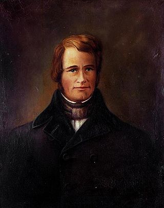
Robert Bylot was an English explorer who made four voyages to the Arctic. He was uneducated and from a working-class background, but was able to rise to rank of master in the English Royal Navy.

Hudson Bay, sometimes called Hudson's Bay, is a large body of saltwater in northeastern Canada with a surface area of 1,230,000 km2 (470,000 sq mi). It is located north of Ontario, west of Quebec, northeast of Manitoba and southeast of Nunavut, but politically entirely part of Nunavut. It is an inland marginal sea of the Arctic Ocean. It drains a very large area, about 3,861,400 km2 (1,490,900 sq mi), that includes parts of southeastern Nunavut, Alberta, Saskatchewan, Ontario, Quebec, all of Manitoba, and parts of the U.S. states of North Dakota, South Dakota, Minnesota, and Montana. Hudson Bay's southern arm is called James Bay.

Hudson Strait in Nunavut links the Atlantic Ocean and the Labrador Sea to Hudson Bay in Canada. This strait lies between Baffin Island and Nunavik, with its eastern entrance marked by Cape Chidley, on the border between Newfoundland and Labrador Nunavut, and Resolution Island off Baffin Island. The strait is about 750 km (470 mi) long with an average width of 125 km (78 mi), varying from 70 km (43 mi) at the eastern entrance to 240 km (150 mi) at Deception Bay.

Pierre-Esprit Radisson (1636/1640–1710) was a French coureur des bois and explorer in New France. He is often linked to his brother-in-law Médard des Groseilliers. The decision of Radisson and Groseilliers to enter the English service led to the formation of the Hudson's Bay Company. His career was particularly notable for its repeated transitions between serving Britain and France.

Saysutshun Provincial Park, formally known as Newcastle Island Marine Provincial Park, is a provincial park located on a small island off the coast of Nanaimo, British Columbia, Canada.
Fort Edmonton was the name of a series of trading posts of the Hudson's Bay Company (HBC) from 1795 to 1914, all of which were located on the north banks of the North Saskatchewan River in what is now central Alberta, Canada. It was one of the last points on the Carlton Trail, the main overland route for Metis freighters between the Red River Colony and the points west and was an important stop on the York Factory Express route between London, via Hudson Bay, and Fort Vancouver in the Columbia District. It also was a connection to the Great Northland, as it was situated relatively close to the Athabasca River whose waters flow into the Mackenzie River and the Arctic Ocean. Located on the farthest north of the major rivers flowing to the Hudson Bay and the HBC's shipping posts there, Edmonton was for a time the southernmost of the HBC's forts.
Thomas Walker Gilmer was an American statesman. He served in several political positions in Virginia, including election as the 28th Governor of Virginia. Gilmer's final political office was as the 15th Secretary of the Navy, but he died in an accident ten days after assuming that position.

Haverstraw Bay, located in New York, is the widest portion of the Hudson River. The width of Haverstraw Bay is approximately 3.4 miles (5.5 km), the length approximately 5 miles (8.0 km) from river kilometer 58 at Croton Point to river kilometer 66 at Stony Point. The bay is bordered by the village of Haverstraw, in Rockland County, to the west and the village of Croton-on-Hudson, in Westchester County, to the east.

HMS Graph was a German Type VIIC U-boat that the British Royal Navy captured during World War II. Commissioned as U-570 in Nazi Germany's Kriegsmarine in mid-1941, she was attacked and captured on her first patrol.
The Methye Portage or Portage La Loche in northwestern Saskatchewan was one of the most important portages in the old fur trade route across Canada. The 19 km (12 mi) portage connected the Mackenzie River basin to rivers that ran east to the Atlantic. It was reached by Peter Pond in 1778 and abandoned in 1883 when steamboats began running on the Athabasca River with links to the railroad. It ranks with Grand Portage as one of the two most important and difficult portages used during the fur trade era.
"Roar, Lion, Roar" is the primary fight song of Columbia University. It was originally titled "Bold Buccaneers" and was written with different lyrics for the 1923 Varsity Show Half Moon Inn by Columbia undergraduates Corey Ford and Morris W. Watkins, and alumnus Roy Webb. In order to compete in the Columbia Alumni Federation's contest to find a school fight song the same year, Ford wrote a new set of lyrics that would become "Roar, Lion, Roar". The title references Columbia's mascot, the Columbia Lion.

Captain George Comer was considered the most famous American whaling captain of Hudson Bay, and the world's foremost authority on Hudson Bay Inuit in the early 20th century.
"Did I Stutter?" is the sixteenth episode of the fourth season of the American comedy television series The Office and the show's sixty-ninth episode overall. Written by Brent Forrester and Justin Spitzer, and directed by Randall Einhorn, the episode first aired in the United States on May 1, 2008 on NBC.

Arctic exploration is the physical exploration of the Arctic region of the Earth. It refers to the historical period during which mankind has explored the region north of the Arctic Circle. Historical records suggest that humankind have explored the northern extremes since 325 BC, when the ancient Greek sailor Pytheas reached a frozen sea while attempting to find a source of the metal tin. Dangerous oceans and poor weather conditions often fetter explorers attempting to reach polar regions, and journeying through these perils by sight, boat, and foot has proven difficult.
The Rae–Richardson Arctic expedition of 1848 was an early British effort to determine the fate of the lost Franklin Polar Expedition. Led overland by Sir John Richardson and John Rae, the party explored the accessible areas along Franklin's proposed route near the Mackenzie and Coppermine rivers. No contact with Franklin's party was achieved and Rae later interviewed the Inuit of the region, from whom he obtained credible accounts that the desperate remnants of Franklin's party had resorted to cannibalism. This revelation was so unpopular that Rae was shunned by the Admiralty and popular opinion; the search for Franklin continued for several years.

USCGC Point Hudson (WPB-82322) was an 82-foot (25 m) Point class cutter constructed at the Coast Guard Yard at Curtis Bay, Maryland in 1961 for use as a law enforcement and search and rescue patrol boat. Since the Coast Guard policy in 1961 was not to name cutters under 100-foot (30 m) in length, it was designated as WPB-82322 when commissioned and acquired the name Point Hudson in January 1964 when the Coast Guard started naming all cutters longer than 65-foot (20 m).
