
The Junction is a neighbourhood in Toronto, Ontario, Canada, that is near the West Toronto Diamond, a junction of four railway lines in the area. The neighbourhood was previously an independent city called West Toronto, that was also its own federal electoral district until amalgamating with the city of Toronto in 1909. The main intersection of the area is Dundas Street West and Keele Street. The Stockyards is the northeastern quadrant of the neighbourhood.

St. Clair Avenue is a major east-west street in Toronto, Ontario, Canada. It was laid out in the late 18th century by the British as a concession road, 2 kilometres (1.2 mi) north of Bloor Street and 4 kilometres (2.5 mi) north of Queen Street.
Runnymede is a subway station on Line 2 Bloor–Danforth of the Toronto subway in Toronto, Ontario, Canada. It is located just north of Bloor Street West, spanning the block east of Runnymede Road to Kennedy Avenue, with bus platforms at the surface level and entrances at both ends. Wi-Fi service is available at this station.

Toronto Civic Railways (TCR) was a streetcar operator created and owned by the City of Toronto, Ontario, Canada, to serve newly annexed areas of the city that the private operator Toronto Railway Company refused to serve. When the Toronto Railway Company's franchise expired in 1921, its services were combined with those of the Toronto Civic Railways, and are now assumed by the new Toronto Transportation Commission (TTC). The first route of the TCR started operation on December 18, 1912.

Bloor Street is a major east–west residential and commercial thoroughfare in Toronto, Ontario, Canada. Bloor Street runs from the Prince Edward Viaduct, which spans the Don River Valley, westward into Mississauga where it ends at Central Parkway. East of the viaduct, Danforth Avenue continues along the same right-of-way. The street, approximately 25 kilometres (16 mi) long, contains a significant cross-sample of Toronto's ethnic communities. It is also home to Toronto's famous shopping street, the Mink Mile.
Eglinton Avenue is a major east–west arterial thoroughfare in Toronto and Mississauga in the Canadian province of Ontario. The street begins at Highway 407 at the western limits of Mississauga, as a continuation of Lower Baseline in Milton. It traverses the midsection of both cities and ends at Kingston Road. Eglinton Avenue is the only street to cross all six former boroughs of Metropolitan Toronto.

Bathurst Street is a main north–south thoroughfare in Toronto, Ontario, Canada. It begins at an intersection of the Queens Quay roadway, just north of the Lake Ontario shoreline. It continues north through Toronto to the Toronto boundary at Steeles Avenue. It is a four-lane thoroughfare throughout Toronto. The roadway continues north into York Region where it is known as York Regional Road 38.

Keele Street is a north–south road in Toronto, Vaughan and King in Ontario, Canada. It stretches 47 kilometres (29 mi), running from Bloor Street in Toronto to the Holland Marsh. South of Bloor Street, the roadway is today known as Parkside Drive, but was originally part of Keele Street. It was renamed in 1921 by the City of Toronto.

Dufferin Street is a major north–south street in Toronto, Vaughan and King, Ontario, Canada. It is a concession road, two concessions (4 km) west of Yonge Street. The street starts at Exhibition Place, continues north to Toronto's northern boundary at Steeles Avenue with some discontinuities and continues into Vaughan, where it is designated York Regional Road 53. The street is named for Frederick Hamilton-Temple-Blackwood, 1st Marquess of Dufferin and Ava, who served as Governor General of Canada from 1872 to 1878. Prior to 1878 the street was labelled as Western City Limits or Sideline Road south off Bloor. In 2003 and 2007, it was voted as one of "Ontario's Worst 20 Roads" in the Ontario's Worst Roads poll organized by the Canadian Automobile Association.

The 512 St. Clair is an east–west streetcar route in Toronto, Ontario, Canada, operated by the Toronto Transit Commission (TTC). It operates on St. Clair Avenue between St. Clair station on the Line 1 Yonge–University subway and Gunns Road, just west of Keele Street.

The 505 Dundas is a Toronto streetcar route run by the Toronto Transit Commission in Ontario, Canada. The route is roughly U-shaped running mainly along Dundas Street between Dundas West and Broadview stations several blocks south of the Line 2 Bloor–Danforth subway.

Rockcliffe–Smythe is a neighbourhood in Toronto, Ontario, Canada. It was developed after World War II as part of the urbanization of the former suburb of York Township. It is in Ward 5 in the City of Toronto.
Royal York Road, historically known as Church Street or New Church Street, is a north-south arterial road in Toronto, Ontario, Canada. It is a concession road, 5 concessions (10 km) west of Yonge Street, and runs through many residential neighbourhoods, most notably Mimico and the Kingsway. It is classified as a "minor arterial" road by the city of Toronto.

Bloor West Village is a residential neighbourhood and shopping district in Toronto, Ontario, Canada. Bordered on the south by Bloor Street, it encompasses all businesses along Bloor Street between South Kingsway and Ellis Park Road, consisting of more than 400 shops, restaurants and services, plus the residential neighbourhood to the north. The official City of Toronto name of the neighbourhood is Runneymede-Bloor West Village.

Lansdowne Avenue is an arterial road in Toronto, Ontario. It runs north–south and starts at Queen Street West and proceeds north to St. Clair Avenue West. Lansdowne Avenue is primarily a four-lane arterial road, with two lanes regularly used for motor vehicle parking.
Runnymede is a neighbourhood in Toronto, Ontario, Canada located north of Bloor Street West between Jane Street and Runnymede Road north to Dundas Street West. It is located directly north of the former village of Swansea and west of the High Park North neighbourhood. The immediate area around Bloor Street is commonly known as Bloor West Village after the shopping area along Bloor Street, whereas the area to the north is considered the Runnymede neighbourhood.
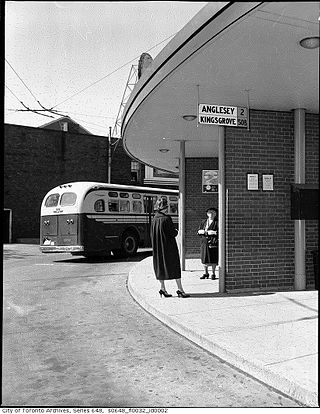
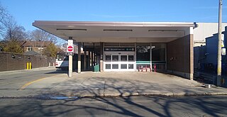
Jane Loop was an important Toronto Transit Commission (TTC) streetcar turning loop and bus station, prior to the completion of the Bloor Danforth Subway line. The Jane Loop opened on December 31, 1923; it was the western end of Bloor Streetcar line from 1925 to 1968. The loop was at a boundary between two zones in the TTC's zoned fare system. Half a dozen or so buses and trolleybuses terminated at the loop.

The Toronto Transit Commission operated the Bloor streetcar line along Bloor Street and Danforth Avenue, extending at its longest from Jane Street in the west end of the city to Luttrell Avenue in the east. Both Luttrell and Jane loops at the termini were transfer points between streetcars and suburban bus routes. The line was abandoned in 1966 with the opening of the Bloor-Danforth subway line, except for two stubs of the line abandoned in 1968.

