
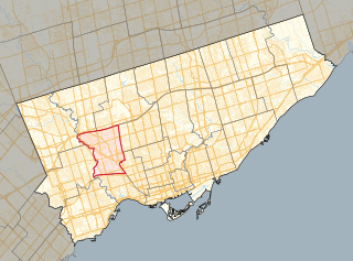
The Junction is a neighbourhood in Toronto, Ontario, Canada, that is near the West Toronto Diamond, a junction of four railway lines in the area. The neighbourhood was previously an independent city called West Toronto, that was also its own federal electoral district until amalgamating with the city of Toronto in 1909. The main intersection of the area is Dundas Street West and Keele Street. The Stockyards is the northeastern quadrant of the neighbourhood.

Parkdale—High Park is a federal electoral district in Ontario, Canada, that has been represented in the House of Commons of Canada since 1979. It was created during the 1976 electoral boundaries redistribution from parts of Parkdale, High Park—Humber Valley, Davenport and Spadina districts. As of the October 19, 2015, Canadian general election, the current Member of Parliament (MP) is Liberal member Arif Virani. According to the 2016 Census, Parkdale—High Park has the lowest percentage of visible minorities (26.2%) among all City of Toronto ridings; it also has the highest percentage of people of Irish (20.0%), German (9.8%), and French (8.9%) ethnic origin of all City of Toronto ridings.
York South—Weston is a federal electoral district in Ontario, Canada, that has been represented in the House of Commons of Canada since 1979.
The Toronto Suburban Railway was a Canadian electric railway operator with local routes in west Toronto, and a radial (interurban) route to Guelph.

Sheppard Avenue is an east–west principal arterial road in Toronto, Ontario, Canada. The street has two distinct branches near its eastern end, with the original route being a collector road leading to Pickering via a turnoff, and the main route following a later-built roadway which runs south to Kingston Road. To avoid name duplication, the Toronto portion of the northern branch was renamed Twyn Rivers Drive. The section of the street entirely in Toronto is (34.2 km) in length, while the Pickering section and Twyn Rivers Dr. is (5.4 km) long.

Keele Street is a north–south road in Toronto, Vaughan and King in Ontario, Canada. It stretches 47 km, running from Bloor Street in Toronto to the Holland Marsh. South of Bloor Street, the roadway is today known as Parkside Drive, but was originally part of Keele Street. It was renamed in 1921 by the City of Toronto.

The CNR Spadina Roundhouse was owned by the Canadian National Railway, built in 1928. The purpose of Spadina Roundhouse was the pretrip inspection, service and repairing of the motive power of passenger trains, including locomotives and Budd Rail Diesel Cars terminating, or originating at Toronto Union Station.
Lambton Yard is a freight marshalling yard for the Canadian Pacific Railway in Toronto, Ontario, Canada, and is located to the west of and contiguous with the West Toronto Yard on the Galt Subdivision. The two were the main freight marshalling yard complex for the CPR in Toronto until replaced by the modern CPR Toronto Yard in Agincourt in April 1964.

The West Toronto Diamond is a railway junction in Toronto, Ontario, Canada. It connects the Metrolinx Weston Subdivision, which carries the GO Transit Kitchener line, UP Express and Via Rail Corridor passenger services, to the CP North Toronto Subdivision, which is the Canadian Pacific Railway's main freight line across Toronto. It is located near the intersection of Keele Street and Dundas Street in Toronto.

Lambton is a neighbourhood in the city of Toronto, Ontario, Canada. It is situated on the east bank of the Humber River north and south of Dundas Street West. It is bounded on the north by Black Creek, on the east by Jane Street and on the south by St. Mark's Road. The area west of Gooch Avenue and south of Dundas Street West is also known as "Warren Park", the name of the housing sub-division built in the 1950s. The portion south of Dundas Street West is within the 'Lambton Baby Point' neighbourhood as defined by the City of Toronto.

CPR Toronto Yard is a facility located in northeast Toronto, Ontario, Canada, often incorrectly referred to as Agincourt Yard because it is located in Agincourt, a neighbourhood of Toronto.
Roundhouse Park is a 17 acre park in the downtown core of Toronto, Ontario, Canada. It is in the former Railway Lands. It features the John Street Roundhouse, a preserved locomotive roundhouse which is home to the Toronto Railway Museum, Steam Whistle Brewing, and the restaurant and entertainment complex The Rec Room. The park is also home to a collection of trains, the former Canadian Pacific Railway Don Station, and the Roundhouse Park Miniature Railway. The park is bounded by Bremner Boulevard, Lower Simcoe Street, Lake Shore Boulevard West/Gardiner Expressway and Rees Street.

The MacMillan Yard is the 2nd largest rail classification yard in Canada, after CN's Symington Yard in Winnipeg. It is operated by Canadian National Railway (CN) and is located in Vaughan, Ontario. It was originally opened in 1965 as Toronto Yard, but was renamed MacMillan Yard in 1975 after former CN president Norman John MacMillan.
Runnymede Road is a street in the west end of Toronto, Canada. It runs from Morningside Avenue at its south end and ends at Henrietta Street, north of St. Clair Ave.

Runnymede Park is a medium-sized public park located in The Junction neighbourhood of Toronto, Canada, one block east of Runnymede Road. Its southern boundary is the West Toronto Yard used by the Canadian Pacific Railway, its northern boundary is Ryding Avenue, while a laneway and parking lot make up the western and eastern boundaries respectively. It is relatively flat, and features many soaring mature oak trees.

The Village of Lambton Mills was a settlement at the crossing of Dundas Street and the Humber River. The settlement was on both sides of the Humber River, in both the former Etobicoke Township and York Township, within today's City of Toronto, Ontario, Canada. It extended as far west as Royal York Road at Dundas, as far north as the still-existing CPR rail line north of Dundas, as far east as Scarlett Road and as far south as today's Queen Anne Road. The area on the east side of the river is still known as Lambton, although the current neighbourhood encompasses very little of the original Lambton Mills village.

Railway Lands is an area in Downtown Toronto, Ontario, Canada. Originally a large railway switching yard near the Toronto waterfront, including the CNR Spadina Roundhouse and the CPR John Roundhouse, it has since been redeveloped and today is home to mostly mixed-used development, including the CN Tower and the Rogers Centre. The lands were owned and maintained by the Canadian National Railway and later transferred to the federal crown corporation Canada Lands Company. The area is bounded by Front Street, Yonge Street, Gardiner Expressway and Bathurst Street. The western portion of the Railway Lands is now part of the CityPlace neighbourhood and the eastern portion is now called South Core.

The Don Mills Trail is a 3-kilometre (1.9 mi) cycling and walking trail in Toronto, Ontario, Canada. The trail runs south from York Mills Road, east of and roughly parallel to Leslie Street. The city built the trail on the roadbed of a former railway line, known as the Leaside Spur.

Parkdale railway station or North Parkdale railway station as it was also known was a passenger train station in Toronto, Ontario, Canada. The station served the Parkdale village on the then-outskirts of Toronto. The station served trains on the Northern Railway of Canada and Credit Valley Railway, later the Canadian Pacific Railway, railways. It was situated at the intersection of Dufferin Street and Queen Street West. The train station was decommissioned in the 1970s.

Via Rail's Toronto Maintenance Centre is a railway yard in the western end of Toronto, which stores and services Via trains. It lies within the south side of the former CN Mimico Yard directly opposite of the Willowbrook Rail Maintenance Facility on the north side; GO Transit's Lakeshore West line separates the two facilities. The yard is bisected by the Islington Avenue flyover bridge. Its main entrance is located at 50 Drummond Street on the eastern side with a secondary entrance on its southern side along New Toronto Street at Eighth Street.
