Bulgaria is a country situated in Southeast Europe that occupies the eastern quarter of the Balkan peninsula, being the largest country within its geographic boundaries. It borders Romania to the north, Serbia and North Macedonia to the west, Greece and Turkey to the south, and the Black Sea to the east. The northern border with Romania follows the river Danube until the city of Silistra. The land area of Bulgaria is 110,994 square kilometres (42,855 sq mi), slightly larger than that of Cuba, Iceland or the U.S. state of Tennessee. Considering its relatively compact territorial size and shape, Bulgaria has a great variety of topographical features. Even within small parts of the country, the land may be divided into plains, plateaus, hills, mountains, basins, gorges, and deep river valleys. The geographic center of Bulgaria is located in Uzana.

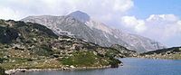
Rila is the highest mountain range of Bulgaria, the Balkan Peninsula, and Southeast Europe. It is situated in southwestern Bulgaria and forms part of the Rila–Rhodope Massif. The highest summit is Musala at an elevation of 2,925 m which makes Rila the sixth highest mountain range in Europe after the Caucasus, the Alps, Sierra Nevada, the Pyrenees and Mount Etna, and the highest one between the Alps and the Caucasus. It spans a territory of 2,629 km2 with an average elevation of 1487 m. The mountain is believed to have been named after the river of the same name, which comes from the Old Bulgarian verb "рыти" meaning "to grub".
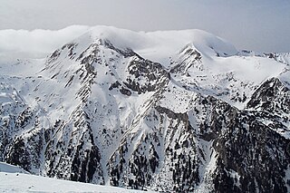
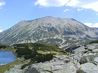
The Pirin Mountains are a mountain range in southwestern Bulgaria, with the highest peak, Vihren, at an altitude of 2,914 m (9,560 ft).
Pirin National Park, originally named Vihren National Park, encompasses the larger part of the Pirin Mountains in southwestern Bulgaria, spanning an area of 403.56 square kilometers (155.82 sq mi).
Vihren is the highest peak of Bulgaria's Pirin Mountains. Reaching 2,914 metres (9,560 ft), it is Bulgaria's second and the Balkans' third highest, after Musala and Mount Olympus. Although Vihren is deprived of lakes and streams due to the karst topography, a number of Pirin's lakes are located around the peak, as is Europe's southernmost glacial mass, the Snezhnika glacieret. Until 1942 Vihren was known as Eltepe ; it was also called Buren (stormy) and Malnienosets (lightning-bringer). The UNESCO World Heritage Site Pirin National Park was originally known as the Vihren National Park. Vihren is included in the 100 Tourist Sites of Bulgaria under No. 2.

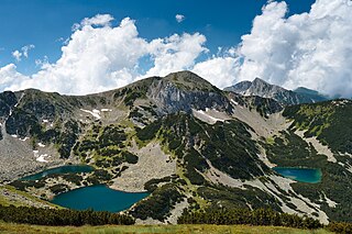
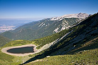
Popovo Lake is a glacial lake situated in the northern section of the Pirin mountain range, south-western Bulgaria. It is one of the eleven Popovi Lakes. The lake and its surroundings are among the most popular places for summer tourism in Pirin National Park. It is situated at the bottom of the Popovski cirque and is surrounded by the peaks Sivria (2,591 m), Dzhano (2,668 m), Kralev Dvor (2,680 m), Momin Dvor (2,723 m) and Dzhengal (2,730 m).

Kremenski Lakes are a glacial lake group in the Pirin mountain range, southwestern Bulgaria. They are located in the Pirin National Park, a UNESCO World Heritage Site. The group consists of nine lakes, seven permanent and two drying, in the narrow salient Kremenski cirque. Kremenski Lakes are surrounded by the summits of Sivria (2,591 m) to the northwest and Dzhano (2,668 m) to the southeast, as well as the Kremenski ridge which ends with Kremenski peak (2,503 m). They drain into the river Retizhe, a right tributary of the Mesta.

The Samodivski Lakes is a small group of lakes in Pirin, southwestern Bulgaria, part of the larger group of Popovski lakes. They are situated very close to each other in a small cirque to the south west of the Popovo Lake between the peak Dzhengal, Momin Dvor and Kralev Dvor. They are situated at an altitude of 2,373 m, 2,375 m, 2,372 m. The highest has a shape of a boat with size of 75x85 m and surface of 3,20 decares; the second one resembles a kidney and is longer with area of 2,20 decares; the lowest is also the smallest one with size of 50x20 m and surface of only 1 decare. The Samodivski lakes are considered as one of the most beautiful in Pirin and with good reason: they are nestled among high rocks, a small stream curves between them which even forms a tiny waterfall between the higher lakes. They names derives from the folklore beliefs that the wood nymphs gather around at night. According to the legend, the area was home of the daughter of the Slavic god Perun. The track between the Bezbog refuge and the Tevno Lake passes nearby. There are suitable places for camping.

The Sinanishko Lake is a glacial lake in the Pirin mountain range, southwestern Bulgaria, situated about 700 m to the north–northeast of the summit of Sinanitsa (2,516 m) in the small Sinanitsa cirque at an altitude of 2,181 m. Reaching depth of 11.5 m, it is among the ten deepest lakes in the mountain range. It has an elongated shape with maximum length of 175 m and a width of 80 m. The surface area is 10,100 m2. Its waters pour out under the ground and they appear on the surface 120 m away from the lake and form the beginning of the river Sinanishka, a left tributary of the Vlahina reka of the Struma river basin. Close to its northern shores is located the Sinanitsa refuge.

The Vlahini Lakes is a group of six lakes, five of which are permanent, in the Pirin mountain range in southwestern Bulgaria, 1.5 km to the southwest from Vihren. The lakes are named after the village of Vlahi, located at a lower altitude. Other names of the lakes include Vihrenski and Eltepski lakes.

The Vasilashki Lakes are situated in Pirin, Bulgaria in a large cirque between the Todorka and Vasilashki Chukar peaks. The cirque is opened to the east, where it faces the Demyanitsa river in which the water of the lakes pour. This cirque also includes the two lakes Todorini Ochi, whose waters goes to one of the Vasilaski lakes. The cirque is amphitheatric and in fact consists of several smaller cirques situated in a fan-shape way above the main one, in which the two largest lakes are located. The lakes are 10 including the two Todorini, with a total surface area of 160 decares. Their name derives from the legent for Vasil, the beloved one of Todorka, who plunged into the Fish Vasilashko lake when she broke his heart. The most important lakes are:

The Tipits Lakes are two lakes that are located in the Tipits cirque of the Northern Pirin mountains of Bulgaria.
Todorka is a massive peak in the Pirin Mountains of south-western Bulgaria. It is the only peak of the Todorka side ridge and has a summit elevation of 2746 m (9009 ft.) above sea level. Todorka is the 11th highest peak in Pirin and is made of granite, and although not rocky, it is steep. It is a relatively short crest with three peaks - Golyama (Big), Sredna (Middle) and Malka (Little) Todorka. Golyama Todorka is located to the north and viewed from the town of Bansko looks like a dramatic pyramid. There are several ski tracks from its slopes, and has been developed extensively since 2000 and is now a major ski area, with a lift-served summit of 2600 m (8530 ft). Bansko hosted World Cup races for the women in 2009 and for the men in 2011.

Banderishki Chukar is a 2,737 m (8,980 ft) peak in the Pirin mountain range, south-western Bulgaria. It is located in the northern part of Pirin on the main mountain ridge. It is the highest granite peak on the main mountain ridge. It is the 12th highest summit in Pirin.

Hvoynati Vrah is a 2,635 m high peak in the Pirin mountain range, south-western Bulgaria. It is situated on the main mountain ridge between the summits of Vihren (2,914 m) and Muratov Vrah (2,669 m). It is built up of granite.
The Salzitsa Lake, also known as Dautovo Lake is a glacial lake in the Pirin mountain range, southwestern Bulgaria. It is situated at an altitude of 2,341 m in a small cirque at about 1 km to the northeast of the summit of Dautov Vrah (2,597 m). It is the northernmost lake in the mountain range.

The Banderitsa is a river in south-western Bulgaria, a left tributary of the Glazne, which flows into the Iztok, itself a right tributary of the river Mesta. The river is 13 km long and drains parts of the northeastern slopes of the Pirin mountain range.

Malokamenishki Lakes, also known as Belemetski Lakes, are a group of 34 glacial lakes situated southwest of the main ridge of Pirin mountain range in Bulgaria. They are the source area of the river Mozgovitsa, one of the tributaries of the Sandanska Bistritsa of the Struma river basin. The lake group is located in the Belemeto cirque, flanked by the main mountain ridge and the secondary ridges of Kamenitsa and Mozgovitsa, crowned by the summits of Kamenitsa Peak (2,822 m), Kralev Dvor (2,680 m), Momin Dvor (2,723 m) and Valyavishki Chukar (2,664 m).
Bezbozhko Lake is a glacial lake in the Pirin mountain range, southwestern Bulgaria. It is located in the Pirin National Park, a UNESCO World Heritage Site.

Bashliyski Lakes are a small group of four glacial lakes situated in the northern part of the Pirin mountain range in southwestern Bulgaria. They are located in the Bashliyski cirque between the summits of Bashliyski Chukar (2,683 m), Banderishki Chukar (2,737 m), Prevalski Chukar (2,605 m) and Tipitsite (2,645 m). They are located in the Pirin National Park, a UNESCO World Heritage Site. The lakes are poorly researched. Their depth is not accurately measured and is estimated at 2–3 m. They are the source of the river Bashliytsa, the uppermost tributary of the Sandanska Bistritsa of the Struma river basin.