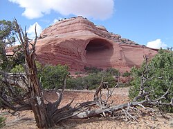
Alcoves are created through weathering, erosion, dry granular flow, and stress. It's also the geographical and geological term for a steep-sided hollow in the side of an exposed rock face or cliff of a homogeneous rock type, that was water eroded. Another factor in the formation of alcoves is winds between mid to late summer that steepen at the edge which leads to the failure and shaping of sand deposition in certain areas. [1]
Location
Although alcoves are both found in the northern and southern hemisphere, more newly developed alcoves are in the northern hemisphere region. Around the North Pole, dune alcoves are formed and scarp avalanches can form. [2]
Alcoves are weathering features common in dissected horizontal strata. Alcoves form where chemical and physical weathering is concentrated along horizontal discontinuities where water and salts concentrate, such as the contact between a sandstone and an underlying shale bed. In the case of layered sandstones, an alcove may later be enlarged by exfoliation of upper layers. This is commonly seen in the sandstone alcoves of the Colorado Plateau, like those in Navajo Sandstone. [3]
Sedimentary rocks are types of rock that are formed by the accumulation or deposition of mineral or organic particles at Earth's surface, followed by cementation. Sedimentation is the collective name for processes that cause these particles to settle in place. The particles that form a sedimentary rock are called sediment, and may be composed of geological detritus (minerals) or biological detritus. The geological detritus originated from weathering and erosion of existing rocks, or from the solidification of molten lava blobs erupted by volcanoes. The geological detritus is transported to the place of deposition by water, wind, ice or mass movement, which are called agents of denudation. Biological detritus was formed by bodies and parts of dead aquatic organisms, as well as their fecal mass, suspended in water and slowly piling up on the floor of water bodies. Sedimentation may also occur as dissolved minerals precipitate from water solution.
Weathering is the deterioration of rocks, soils and minerals as well as wood and artificial materials through contact with water, atmospheric gases, and biological organisms. Weathering occurs in situ, and so is distinct from erosion, which involves the transport of rocks and minerals by agents such as water, ice, snow, wind, waves and gravity.
A natural arch, natural bridge, or rock arch is a natural landform where an arch has formed with an opening underneath. Natural arches commonly form where inland cliffs, coastal cliffs, fins or stacks are subject to erosion from the sea, rivers or weathering.
Sedimentology encompasses the study of modern sediments such as sand, silt, and clay, and the processes that result in their formation, transport, deposition and diagenesis. Sedimentologists apply their understanding of modern processes to interpret geologic history through observations of sedimentary rocks and sedimentary structures.
Spheroidal weathering is a form of chemical weathering that affects jointed bedrock and results in the formation of concentric or spherical layers of highly decayed rock within weathered bedrock that is known as saprolite. When saprolite is exposed by physical erosion, these concentric layers peel (spall) off as concentric shells much like the layers of a peeled onion. Within saprolite, spheroidal weathering often creates rounded boulders, known as corestones or woolsack, of relatively unweathered rock. Spheroidal weathering is also called onion skin weathering,concentric weathering,spherical weathering, or woolsack weathering.
A mesa is an isolated, flat-topped elevation, ridge or hill, which is bounded from all sides by steep escarpments and stands distinctly above a surrounding plain. Mesas characteristically consist of flat-lying soft sedimentary rocks capped by a more resistant layer or layers of harder rock, e.g. shales overlain by sandstones. The resistant layer acts as a caprock that forms the flat summit of a mesa. The caprock can consist of either sedimentary rocks such as sandstone and limestone; dissected lava flows; or a deeply eroded duricrust. Unlike plateau, whose usage does not imply horizontal layers of bedrock, e.g. Tibetan Plateau, the term mesa applies exclusively to the landforms built of flat-lying strata. Instead, flat-topped plateaus are specifically known as tablelands.
The Elbe Sandstone Mountains, also called the Elbe Sandstone Highlands, are a mountain range straddling the border between the state of Saxony in southeastern Germany and the North Bohemian region of the Czech Republic, with about three-quarters of the area lying on the German side. In both countries, core parts of the mountain range have been declared a national park. The name derives from the sandstone which was carved by erosion. The river Elbe breaks through the mountain range in a steep and narrow valley.
The exposed geology of the Bryce Canyon area in Utah shows a record of deposition that covers the last part of the Cretaceous Period and the first half of the Cenozoic era in that part of North America. The ancient depositional environment of the region around what is now Bryce Canyon National Park varied from the warm shallow sea in which the Dakota Sandstone and the Tropic Shale were deposited to the cool streams and lakes that contributed sediment to the colorful Claron Formation that dominates the park's amphitheaters.
A hoodoo is a tall, thin spire of rock formed by erosion. Hoodoos typically consist of relatively soft rock topped by harder, less easily eroded stone that protects each column from the elements. They generally form within sedimentary rock and volcanic rock formations.
A dike or dyke, in geological usage, is a sheet of rock that is formed in a fracture of a pre-existing rock body. Dikes can be either magmatic or sedimentary in origin. Magmatic dikes form when magma flows into a crack then solidifies as a sheet intrusion, either cutting across layers of rock or through a contiguous mass of rock. Clastic dikes are formed when sediment fills a pre-existing crack.
In structural geology, an anticline is a type of fold that is an arch-like shape and has its oldest beds at its core, whereas a syncline is the inverse of an anticline. A typical anticline is convex up in which the hinge or crest is the location where the curvature is greatest, and the limbs are the sides of the fold that dip away from the hinge. Anticlines can be recognized and differentiated from antiforms by a sequence of rock layers that become progressively older toward the center of the fold. Therefore, if age relationships between various rock strata are unknown, the term antiform should be used.
Exfoliation joints or sheet joints are surface-parallel fracture systems in rock, and often leading to erosion of concentric slabs. (See Joint ).
In geology, a graded bed is one characterized by a systematic change in grain or clast size from one side of the bed to the other. Most commonly this takes the form of normal grading, with coarser sediments at the base, which grade upward into progressively finer ones. Such a bed is also described as fining upward. Normally graded beds generally represent depositional environments which decrease in transport energy as time passes, but these beds can also form during rapid depositional events. They are perhaps best represented in turbidite strata, where they indicate a sudden strong current that deposits heavy, coarse sediments first, with finer ones following as the current weakens. They can also form in terrestrial stream deposits.
Stylolites are serrated surfaces within a rock mass at which mineral material has been removed by pressure dissolution, in a deformation process that decreases the total volume of rock. Minerals which are insoluble in water, such as clays, pyrite and oxides, as well as insoluble organic matter, remain within the stylolites and make them visible. Sometimes host rocks contain no insoluble minerals, in which case stylolites can be recognized by change in texture of the rock. They occur most commonly in homogeneous rocks, carbonates, cherts, sandstones, but they can be found in certain igneous rocks and ice. Their size vary from microscopic contacts between two grains (microstylolites) to large structures up to 20 m in length and up to 10 m in amplitude in ice. Stylolites usually form parallel to bedding, because of overburden pressure, but they can be oblique or even perpendicular to bedding, as a result of tectonic activity.
The Ecca Group is the second of the main subdivisions of the Karoo Supergroup of geological strata in southern Africa. It mainly follows conformably after the Dwyka Group in some sections, but in some localities overlying unconformably over much older basement rocks. It underlies the Beaufort Group in all known outcrops and exposures. Based on stratigraphic position, lithostratigraphic correlation, palynological analyses, and other means of geological dating, the Ecca Group ranges between Early to earliest Middle Permian in age.
This glossary of geology is a list of definitions of terms and concepts relevant to geology, its sub-disciplines, and related fields. For other terms related to the Earth sciences, see Glossary of geography terms.
Arches National Park is a national park in eastern Utah, United States. The park is adjacent to the Colorado River, 4 miles (6 km) north of Moab, Utah. More than 2,000 natural sandstone arches are located in the park, including the well-known Delicate Arch, as well as a variety of unique geological resources and formations. The park contains the highest density of natural arches in the world.
The South German Scarplands is a geological and geomorphological natural region or landscape in Switzerland and the south German states of Bavaria and Baden-Württemberg. The landscape is characterised by escarpments.
Cape Town lies at the south-western corner of the continent of Africa. It is bounded to the south and west by the Atlantic Ocean, and to the north and east by various other municipalities in the Western Cape province of South Africa.
Except where underlain by the Sixtymile Formation, Cambrian Tapeats Sandstone is typically the lowest geologic unit, about 230 feet (70 m) thick, at its maximum, of the 5-member Tonto Group. It is famous for being the highly-resistant mostly-horizontal unit above the Great Unconformity expressed areally in the Grand Canyon of Arizona; also in other areas of Arizona and adjacent Nevada.