Pier 40

Last updated

Pier 40
Pier 40 at Hudson River Park, The Pier
Pier 40 Hudson River Park and Pier 45, 46 in Manhattan.JPG
Pier 40 (front) and piers 45 and 46, as seen from One World Observatory
Pier 40
Address353 West Street, Manhattan, New York 10014
Location Greenwich Village
Coordinates 40°43′45″N74°00′45″W / 40.72917°N 74.01250°W / 40.72917; -74.01250
Public transit Subway: 1 train to Houston Street
Bus: M21
Owner State of New York
City of New York
Operator Hudson River Park Trust
TypeMulti-purpose
Seating typeMovable bleachers
Field size400 × 400 feet
Field shapeSquare
Acreage 15
Surface Turf
Construction
Broke groundJuly 31, 1958 [1]
OpenedOctober 24, 1962 (as ship terminal) [2] [3]
May 12, 2005 (as Hudson River Park) [4] [5]
Renovated1998–2005
Construction cost$19 million
Tenants
New York Knights

Pier 40 (officially known as Pier 40 at Hudson River Park) is a parking garage, sports facility, and former marine terminal at the west end of Houston Street in Manhattan, New York, within Hudson River Park. It is home to the New York Knights of the USA Rugby League, though it is primarily used by youth and high school athletics.

Contents

Pier 40 was originally one of five "finger" piers numbered 37 through 41, which were owned by the government of New York City, and were used by various transport companies. In 1956, the city announced a plan to consolidate the five piers into a single large passenger and cargo terminal serving the Holland America Line. Construction began in 1958 and the terminal was opened in 1962. When the Holland America Line moved to the New York Passenger Ship Terminal in 1974, the pier continued to be used by ships until 1983. Afterward, the New York State Department of Transportation purchased the pier as part of its failed Westway expressway proposal, with plans to use the pier for parking. Pier 40 was redesignated as parkland in 1998; several options for the structure were proposed, including redevelopment as a soccer stadium or an entertainment complex. [6] It reopened in 2005 as a sporting complex within Hudson River Park.

The former cargo terminal is the largest structure in Hudson River Park, with an area of 14.5 acres (5.9 ha), [6] and houses the Hudson River Park Trust's offices. [7] Various park tenants host activities in Pier 40 as well. Sports include baseball, football, soccer, boat building, [8] rowing, trapeze arts, and rugby among others. Despite its popularity, the terminal is dilapidated and sinking into the Hudson River, and was previously proposed for closure due to its deteriorated condition.

History

Cargo terminal and parking lot

The side of Pier 40. Manhattan - Pier 40 - 01 (9440475213).jpg
The side of Pier 40.

Prior to the construction of Pier 40, five city-owned "finger" piers were located at the site. From south to north, these were Pier 37 (at Charlton Street), Pier 38 (at King Street), Pier 39 (at West Houston Street), Pier 40 (at Clarkson Street), and Pier 41 (at Leroy Street). Companies using the piers in the early 20th century included the Southern Pacific Transportation Company, the Delaware, Lackawanna and Western Railroad (DL&W), and the Atlantic Transport Line. By the 1950s, the piers were used by the DL&W and the Baltimore and Ohio Railroad. [9] [10] [11] [12]

The current Pier 40 was proposed as a passenger and cargo terminal in February 1956 by the city's Marine and Aviation Department. The plan was put forward to allow the Holland America Line to move its area operations from Hoboken, New Jersey on the other side of the Hudson River, where the company was based for 73 years. [11] It was the first terminal of its kind to be built by the city, and was designed as a "massive hollow square" with three levels to accommodate cars, taxis, and commercial trucks. The massive four-block structure replaced the five smaller "finger" piers. [9] [10] [11] Construction began on July 31, 1958, [1] at a projected cost of over $18 million. [9] [10] The pier began operations in 1962, [2] with Holland America signing a 20-year lease for over $1.2 million in annual rent. [13] [14] Holland America also moved its offices from the Financial District to Pier 40. [14] In its first year in operation, Pier 40 served over 2,000 passengers daily. [15] In 1971, the Pier was taken over by the Port Authority of New York and New Jersey. [16] Holland America moved their operations to the New York Passenger Ship Terminal in Hell's Kitchen in 1974. [17] [18] Pier 40 ceased serving ships at that time, and ended all operations around 1983. [17] [18]

Following the cessation of maritime operations, in 1982 the Pier was purchased by the State of New York for the failed Westway project. [16] [18] Under the New York State Department of Transportation's operations, [19] its primary use was as a parking complex for cars, buses and trucks, as well as commercial warehousing. [18] [20] [3] Bus, truck, and warehousing activity ended in 2004. [21] [22] [23]

Park use

The facility was rededicated under the Hudson River Park act of 1998. [24] [25] At this time, two small athletic fields opened on the pier's roof. [4] Between 1998 and 2003, several plans abound for the redevelopment of the site. One was an entertainment complex featuring movie theaters and Cirque du Soleil performances. Another plan sought to construct a public high school along with swimming pools and retail space, in addition to conventional sports fields. [26] Additional plans called for a branch of the Guggenheim Museum, [27] and a big-box store. [28] [29] Ultimately, a plan backed by the community won out, [30] and the pier currently serves the dual purpose of commercial parking garage (located in the outer perimeter of the pier) and a multi-purpose sports facility (encompassing the center of the facility and small sections of the upper level). The main field, occupying the former cargo level, began construction in 2004, and opened in May 2005 with Governor George Pataki and professional soccer player Eddie Johnson in attendance. [4] [5] [26] The sports fields were intended as an interim solution, until a major development would take place. [23] [31] According to the Hudson River Park Trust, the facility generates $6 million in operating revenue and 40 percent of the entire park's annual operating budget. [6] [32]

Following Hurricane Sandy in 2012, the pier was closed after being engulfed by more than 12 feet (3.7 m) of water. [33] The fields reopened on December 19 following a $50,000 donation to fix the damaged turf surface, [34] while full power was restored by spring 2013. [35]

Condition and use

Drone photograph of Pier 40 Manhattan20160507-021-1 (26789452202).jpg
Drone photograph of Pier 40

Pier 40's design resembles a square donut, with the three decks hollowed in the center by the central courtyard. [13] [30] [36] The outer facade consists of tan brick and blue-grey enamel. [13] The outer decks, also referred to by the Hudson River Park Trust as the pier's "shed", are 175 feet (53 m) wide. [36] The pier's base is made of concrete. [10] [36] Extending 810 feet (250 m) west out of Manhattan island over the Hudson River, [36] [37] the pier is held up by more than 3,500 steel H-pile girders reinforced by concrete sunk into the river. [9] [36] At the southwest corner of the site is a "finger pier" extending a further 142 feet (43 m) west. [36]

According to several reports, the Pier is severely dilapidated and gradually sinking into the Hudson River. [21] [22] [38] Sections of the roof have fallen in, and portions of the garage, a stairwell, bathrooms, and one of the upper fields, have been closed since 2012. A 2014 report found that over half of the facility's 3,500 steel girders that hold it above the river are severely deteriorated, possibly due to the electrical rust-protection system being shut down during the 1970s fiscal crisis. The turf field is also subject to flooding and warping after heavy precipitation, even though turf fields are typically designed to optimize drainage. [36] In spite of the revenue the facility generates, Hudson River Park officials have discussed closing the park due to the $7 million annual financial burden required to maintain it. [6] [21] [22] [30]

As a marine terminal

The pier's three decks were used for the loading and unloading of cars, taxis, and trucks, which alleviated congestion on local streets. The ground floor was dedicated to cargo operations, with the central courtyard utilized for the parking and loading of up to 350 trucks simultaneously. The second floor was used for passenger operations, serving taxis picking up arriving passengers, and featuring a furnished waiting room. The roof served as parking for over 700 cars, and ramps connected the three levels. [2] [13]

As Hudson River Park

Pier 40 Hudson 08.jpg
Pier 40 Hudson 05.jpg
Pier 40's adult baseball field (top), and the walkway and netting circumscribing the field (bottom).

The pier's outer decks now act as a parking garage. The car park, a self-parking facility, has a 1,700-car capacity (formerly accommodating approximately 2,000) and serves over 1,500 drivers. [21] [22] [23]

The upper-level recreational area, opened in 1998, features two fields (one small field and one soccer field) and a "flying trapeze" operated by the Trapeze School of New York. [21] [24] [39] [40] The fields were resurfaced in 2004. [41] The rooftop field measures 120 by 210 feet (37 by 64 m). [42]

The 400-by-400-foot (120 by 120 m) main athletic field at ground level (called the courtyard field) is constructed of modern artificial turf manufactured by FieldTurf, consisting of plastic grass blades submerged in recycled rubber pellets. Construction of the field began in 2004, [39] and the field was opened in May 2005. [4] [31] [41] [43] The regulation-size baseball field is located at the southwest corner of the park, while the Little League/softball field is located at the northeast corner. Both fields feature imitation-dirt turf cut-outs, base anchors, dugout, and synthetic turf pitching mounds. [31] Indoor batting cages are located near the baseball field. [44] The center of the park (east-to-west) is marked up for football, with movable goal posts and practice sleds. Several movable soccer goals are also located around the ground floor field, which can be set up into two or four soccer pitches covering each half or each corner of the field respectively. [40] [42] At some point, black nets were installed around the field to prevent balls from flying into the asphalt walkway that surrounds the perimeter of the sports field. The facility also features twelve stadium lighting fixtures, allowing night games to be played. [45]

Prior to 2008, Public Schools Athletic League (PSAL)-sanctioned high school baseball games could not be played at Pier 40. This was because the portable mounds owned by the facility, which were 13 feet (4.0 m) in diameter, did not meet the specifications of the league. The portable mounds (as opposed to a permanent dirt mound) were required to maintain the multi-purpose status of the field. In 2008, after lobbying by the nearby Stuyvesant High School, a new mound was purchased from an Iowa-based company that was 18 feet (5.5 m) in diameter. The new mound, consisting of a center and two side pieces, was the first mound of its kind, and allowed for PSAL league games to be played. [43] [46]

Spaces on the southern side of the pier are occupied by several nonprofit organizations such as the Village Community Boathouse, the River Project, and New York Outrigger, as well as a commercial a kayak shop. The Village Community Boathouse builds and stores traditional wooden rowboats there. [47] [48] [49] During the summer months these boats, called Whitehall gigs, are launched at least twice weekly for free public rowing trips up and down the Hudson River. [49] There is also a mooring field, maintained by the Hudson River Park Trust, that offers seasonal and daily moorings for recreational sail and motor boats. [50]

Future development

Pier 40's entrance Pier 40 Hudson 01.jpg
Pier 40's entrance

When established as a park in 1998, Pier 40 was zoned for exclusively entertainment and retail purposes, with half of the pier required to be set aside for recreation. [22] [24] [25] Because of the facility's condition, several proposals have been made to increase revenue to the park for repairs, which were estimated to cost anywhere between tens and hundreds of millions of dollars. [33] A 2012 proposal from local real estate developer and former Friends of Hudson River Park chairman Douglas Durst would consolidate the current parking facilities from a self-park to three-level stacked parking, freeing up 500,000 square feet on the roof for commercial space. The plan did not gain support. [21] [33] A 2014 proposal would demolish and redevelop the building across the street into a residential and retail facility over the course of 10 years, which would require the sale of Pier 40's air rights but would generate an estimated $100 million in revenue. [6] [51] This plan was reportedly canceled following public and political opposition. [52]

In 2012, reports surfaced that the then-new Major League Soccer team New York City FC, which plays at Yankee Stadium in the Bronx, were seeking to develop a new soccer stadium at the Pier 40 site. Renderings of this proposed stadium were leaked online. [53] The plan was scrapped in 2015 due to local opposition. [54] [55]

Tenants

Professional

Amateur and youth

Related Research Articles

<span class="mw-page-title-main">Riverside Park (Manhattan)</span> Public park in New York City

Riverside Park is a scenic waterfront public park in the Upper West Side, Morningside Heights, and Hamilton Heights neighborhoods of the borough of Manhattan in New York City. The park measures 4 miles (6.4 km) long and 100 to 500 feet wide, running between the Hudson River and Henry Hudson Parkway to the west and the serpentine Riverside Drive to the east.

<span class="mw-page-title-main">PATH (rail system)</span> Rapid transit system in New Jersey and New York

The Port Authority Trans-Hudson (PATH) is a 13.8-mile (22.2 km) rapid transit system in the northeastern New Jersey cities of Newark, Harrison, Jersey City, and Hoboken, as well as Lower and Midtown Manhattan in New York City. It is operated as a wholly owned subsidiary of the Port Authority of New York and New Jersey. PATH trains run around the clock year-round; four routes serving 13 stations operate during the daytime on weekdays, while two routes operate during weekends, late nights, and holidays. It crosses the Hudson River through cast iron tunnels that rest on the river bottom. It operates as a deep-level subway in Manhattan and the Jersey City/Hoboken riverfront; from Grove Street in Jersey City to Newark, trains run in open cuts, at grade level, and on elevated track. In 2023, the system saw 55,109,100 rides, or about 187,000 per weekday in the fourth quarter of 2023.

<span class="mw-page-title-main">North River (Hudson River)</span> Section of the Hudson River between New York City and New Jersey

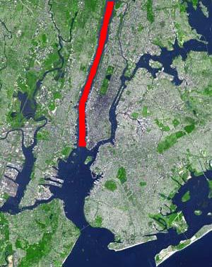
North River is an alternative name for the southernmost portion of the Hudson River in the vicinity of New York City and northeastern New Jersey in the United States.

<span class="mw-page-title-main">Port Authority Bus Terminal</span> Bus station in Manhattan, New York

The Port Authority Bus Terminal is a bus terminal located in Manhattan in New York City. It is the busiest bus terminal in the world by volume of traffic, serving about 8,000 buses and 225,000 people on an average weekday and more than 65 million people a year.

<span class="mw-page-title-main">23rd Street (Manhattan)</span> West-east street in Manhattan, New York

23rd Street is a broad thoroughfare in the New York City borough of Manhattan, one of the major two-way, east-west streets in the borough's grid. As with Manhattan's other "crosstown" streets, it is divided into its east and west sections at Fifth Avenue. The street runs from Avenue C and FDR Drive in the east to Eleventh Avenue in the west.

<span class="mw-page-title-main">West Side Highway</span> Boulevard in Manhattan, New York

The Joe DiMaggio Highway, commonly called the West Side Highway and formerly the Miller Highway, is a 5.42-mile-long (8.72 km) mostly surface section of New York State Route 9A (NY 9A), running from West 72nd Street along the Hudson River to the southern tip of Manhattan in New York City. It replaced the West Side Elevated Highway, built between 1929 and 1951, which was shut down in 1973 due to neglect and lack of maintenance, and was dismantled by 1989. North of 72nd Street the roadway continues north as the Henry Hudson Parkway.

<span class="mw-page-title-main">Thirteenth Avenue (Manhattan)</span> Street in Manhattan, New York

Thirteenth Avenue was a street in the New York City borough of Manhattan, New York City. It was built in 1837 along the Hudson River. The avenue was later removed in the early 20th century to make way for the Chelsea Piers.

<span class="mw-page-title-main">NY Waterway</span> Ferry company

NY Waterway, or New York Waterway, is a private transportation company running ferry and bus service in the Port of New York and New Jersey and in the Hudson Valley. The company utilizes public-private partnership with agencies such as the Port Authority of New York and New Jersey, New Jersey Transit, New York City Department of Transportation, and Metropolitan Transportation Authority to provide service and maintain docking facilities.

<span class="mw-page-title-main">Chelsea Piers</span> Entertainment complex in Manhattan, New York

Chelsea Piers is a series of piers in Chelsea, on the West Side of Manhattan in New York City. Located to the west of the West Side Highway and Hudson River Park and to the east of the Hudson River, they were originally a passenger ship terminal in the early 1900s that was used by the RMS Lusitania and was the destination of the RMS Carpathia after rescuing the survivors of the RMS Titanic. The piers replaced a variety of run-down waterfront structures with a row of grand buildings embellished with pink granite facades.

<span class="mw-page-title-main">High Line</span> Linear park in New York City

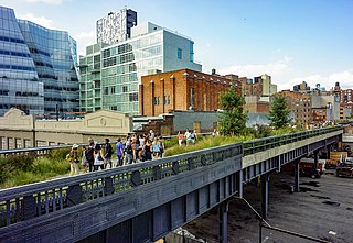
The High Line is a 1.45-mile-long (2.33 km) elevated linear park, greenway, and rail trail created on a former New York Central Railroad spur on the west side of Manhattan in New York City. The High Line's design is a collaboration between James Corner Field Operations, Diller Scofidio + Renfro, and Piet Oudolf. The abandoned spur has been redesigned as a "living system" drawing from multiple disciplines which include landscape architecture, urban design, and ecology. The High Line was inspired by the 4.7 km (2.9 mi) long Coulée verte, a similar project in Paris completed in 1993.

<span class="mw-page-title-main">Hudson River Park</span> Public park in Manhattan, New York

Hudson River Park is a waterfront park on the North River that extends from 59th Street south to Battery Park in the New York City borough of Manhattan. The park, a component of the Manhattan Waterfront Greenway, stretches 4.5 miles (7.2 km) and comprises 550 acres (220 ha), making it the second-largest park in Manhattan after the 843-acre (341 ha) Central Park.

<span class="mw-page-title-main">Manhattan Cruise Terminal</span> Ship terminal in Manhattan, New York

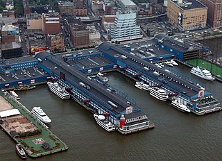
The Manhattan Cruise Terminal, formerly known as the New York Passenger Ship Terminal or Port Authority Passenger Ship Terminal is a ship terminal for ocean-going passenger ships in Hell's Kitchen, Manhattan, New York City. It was constructed and expanded in the 1920s and 1930s as a replacement for the Chelsea Piers.

<span class="mw-page-title-main">Fort Washington Park (Manhattan)</span> Public park in Manhattan, New York

Fort Washington Park is a public park located in the Washington Heights section of Upper Manhattan in New York City. It runs along the banks of the Hudson River next to Riverside Drive and the Henry Hudson Parkway from West 155th Street to Dyckman Street. The George Washington Bridge crosses above the park; below the bridge is a small point of land called Jeffrey's Hook, which is the site of the Little Red Lighthouse.

<span class="mw-page-title-main">Brooklyn Bridge Park</span> Public park in Brooklyn, New York

Brooklyn Bridge Park is an 85-acre (34 ha) park on the Brooklyn side of the East River in New York City. Designed by landscape architecture firm Michael Van Valkenburgh Associates, the park is located on a 1.3-mile (2.1 km) plot of land from Atlantic Avenue in the south, under the Brooklyn Heights Promenade and past the Brooklyn Bridge, to Jay Street north of the Manhattan Bridge. From north to south, the park includes the preexisting Empire–Fulton Ferry and Main Street Parks; the historic Fulton Ferry Landing; and Piers 1–6, which contain various playgrounds and residential developments. The park also includes Empire Stores and the Tobacco Warehouse, two 19th-century structures, and is a part of the Brooklyn Waterfront Greenway, a series of parks and bike paths around Brooklyn.

<span class="mw-page-title-main">Industry City</span> Historic intermodal shipping, warehousing, and manufacturing complex in Brooklyn, New York

Industry City is a historic intermodal shipping, warehousing, and manufacturing complex on the Upper New York Bay waterfront in the Sunset Park neighborhood of Brooklyn, New York City. The northern portion, commonly called "Industry City" on its own, hosts commercial light manufacturing tenants across 6,000,000 square feet (560,000 m2) of space between 32nd and 41st Streets, and is operated by a private consortium. The southern portion, known as "Bush Terminal", is located between 40th and 51st Streets and is operated by the New York City Economic Development Corporation (NYCEDC) as a garment manufacturing complex.

<span class="mw-page-title-main">City Pier A</span> Pier in Manhattan, New York

Pier A, also known as City Pier A, is a pier in the Hudson River at Battery Park in Lower Manhattan, New York City. It was built from 1884 to 1886 as the headquarters of the New York City Board of Dock Commissioners and the New York City Police Department (NYPD)'s Harbor Department. Pier A, the only remaining masonry pier in New York City, contains a two- and three-story structure with a clock tower facing the Hudson River. The pier is a New York City designated landmark and is listed on the National Register of Historic Places (NRHP).

<span class="mw-page-title-main">Municipal Asphalt Plant</span> Recreation center in Manhattan, New York

The Municipal Asphalt Plant is a former asphalt plant at York Avenue and 91st Street on the Upper East Side of Manhattan in New York City, United States, housing the Asphalt Green recreation center. The asphalt plant was completed in 1944 to designs by Ely Jacques Kahn and Robert Allan Jacobs. The current structure, originally a mixing plant, reopened as the George and Annette Murphy Center in 1984. The asphalt plant, which formerly included a conveyor belt and storage facility, produced asphalt that was used to pave roads in Manhattan. The Murphy Center is a New York City designated landmark and is listed on the National Register of Historic Places.

<span class="mw-page-title-main">The Battery (Manhattan)</span> Public park in Manhattan, New York

The Battery, formerly known as Battery Park, is a 25-acre (10 ha) public park located at the southern tip of Manhattan Island in New York City facing New York Harbor. It is bounded by Battery Place on the north, with Bowling Green to the northeast, State Street on the east, New York Harbor to the south, and the Hudson River to the west. The park contains attractions such as an early 19th-century fort named Castle Clinton; multiple monuments; and the SeaGlass Carousel. The surrounding area, known as South Ferry, contains multiple ferry terminals, including the Staten Island Ferry's Whitehall Terminal; a boat launch to the Statue of Liberty National Monument ; and a boat launch to Governors Island.

<span class="mw-page-title-main">Little Island at Pier 55</span> Park in Manhattan, New York

Little Island at Pier 55 is an artificial island park in the Hudson River west of Manhattan in New York City, adjoining Hudson River Park. Designed by Heatherwick Studio, it is near the intersection of West Street and West 13th Street in the Meatpacking District and Chelsea neighborhoods of Manhattan. It is located slightly west of the Manhattan shoreline atop Hudson River Pier 55, connected to Hudson River Park in Manhattan by footbridges at 13th and 14th Streets. Little Island has two concession stands, a small stage, and a 687-seat amphitheater.

<span class="mw-page-title-main">St. John's Terminal</span> Building in Manhattan, New York

St. John's Terminal, also known as 550 Washington Street, is a building on Washington Street in the Hudson Square neighborhood of Manhattan in New York City. Designed by Edward A. Doughtery, it was built in 1934 by the New York Central Railroad as a terminus of the High Line, an elevated freight line along Manhattan's West Side used for transporting manufacturing-related goods. The terminal could accommodate 227 train cars. The three floors, measuring 205,000 square feet (19,000 m2) each, were the largest in New York City at the time of their construction.

References

  1. 1 2 "Flashback: Cementing Pier 40's place in Hudson history". The Villager . August 5, 2008. Archived from the original on March 4, 2016. Retrieved March 20, 2015.
  2. 1 2 3 Bamberger, Werner (October 25, 1962). "Pier 40 Dedicated By City Officials; Terminal May Be Ready for Use in 2 Months" (PDF). The New York Times . ISSN   0362-4331 . Retrieved March 22, 2015.
  3. 1 2 Kilgannon, Corey (July 25, 1999). "Neighborhood Report: Hudson River Waterfront; Anchoring a Cruise Ship Pier for Earthly Pleasures". The New York Times . ISSN   0362-4331. Archived from the original on April 2, 2015. Retrieved March 22, 2015.
  4. 1 2 3 4 Anderson, Lincoln (May 18, 2005). "Things are kicking at the new Pier 40 athletic field". The Villager . Archived from the original on March 4, 2016. Retrieved March 20, 2015.
  5. 1 2 Governor George Pataki (May 12, 2005). "Governor Opens New 3.2 Acre Athletic Field in Hudson River Park". Project Vote Smart. Archived from the original on April 2, 2015. Retrieved March 22, 2015.
  6. 1 2 3 4 5 Bagli, Charles V. (May 15, 2014). "Possible Deal May Bring Money to Repair Pier 40 in Manhattan". The New York Times . ISSN   0362-4331. Archived from the original on April 2, 2015. Retrieved March 19, 2015.
  7. "Contact us". Hudson River Park . Retrieved March 19, 2015.
  8. "Village Community Boathouse – Pier 40". Village Community Boathouse. Archived from the original on April 2, 2019. Retrieved June 11, 2019.
  9. 1 2 3 4 "Work Begins Soon On Mammoth Pier: Contract Signing Will Clear Way for Holland-America Facility, Port's Biggest" (PDF). The New York Times . March 28, 1958. ISSN   0362-4331 . Retrieved March 22, 2015.
  10. 1 2 3 4 Rebuilding New York City's Waterfront: 1959 Progress. New York City Department of Marine & Aviation. 1959. Retrieved May 25, 2016.
  11. 1 2 3 Rebuilding New York City's Waterfront: A Progress Report to Robert F. Wagner, Mayor. New York City Department of Marine & Aviation. September 5, 1956. Retrieved May 25, 2016.
  12. See:
  13. 1 2 3 4 Berkvist, Robert (April 28, 1963). "Peerless Pier 40; City's Newest West Side Ship Terminal Represents a Dockside Revolution" (PDF). The New York Times . ISSN   0362-4331 . Retrieved March 22, 2015.
  14. 1 2 "New York City Marine Facility Now Operating". Niagara Falls Gazette . New York City. Fultonhistory.com. February 25, 1963. Retrieved March 20, 2016.
  15. "Pier a Year Old; City Aide Feted by Holland-America to Mark Move" (PDF). The New York Times . March 13, 1964. ISSN   0362-4331 . Retrieved March 29, 2015.
  16. 1 2 Hine, Bill; Smith, Robert (July 8, 2008). "Talking Point: Authority should be zapped for Pier 40's sorry state". The Villager . Archived from the original on February 7, 2017. Retrieved May 25, 2016.
  17. 1 2 Brouwer, Norman; La Rocco, Barbara (2004). "Epilogue" (PDF). A maritime history of New York. New York City: Going Coastal. pp. 262–295. ISBN   978-0972980319. Archived (PDF) from the original on June 15, 2016. Retrieved May 25, 2016.
  18. 1 2 3 4 West Side Highway Project: Final Environmental Impact Statement. Federal Highway Administration, New York State Department of Transportation, United States Department of Transportation. January 4, 1977. pp. 9, 53, 58, 60, 172. Retrieved May 25, 2016.
  19. 1 2 3 4 5 Anderson, Lincoln (March 7, 2013). "Champs pitch towers plan; Durst goes to bat for reuse". The Villager . Archived from the original on March 22, 2016. Retrieved March 20, 2016.
  20. See:
  21. 1 2 3 4 5 6 Cuozzo, Steve (August 28, 2012). "Pier 40: Durst to the rescue". New York Post . Archived from the original on April 3, 2015. Retrieved March 20, 2015.
  22. 1 2 3 4 5 Foderaro, Lisa W. (August 17, 2012). "Repair Costs Could Bring Down a Popular Pier". The New York Times . ISSN   0362-4331. Archived from the original on April 3, 2015. Retrieved March 20, 2015.
  23. 1 2 3 Amateau, Albert (January 9, 2004). "Trust sued over Pier 40 delays". Downtown Express . Archived from the original on February 7, 2017. Retrieved March 20, 2016.
  24. 1 2 3 Anderson, Lincoln (December 1, 2006). "Cirque tries to swing Pier 40 deal". Downtown Express. Archived from the original on September 23, 2015. Retrieved March 20, 2015.
  25. 1 2 Martin, Douglas (July 30, 1998). "Hudson Park Draws Closer To Reality; Proponents Celebrate Approval by Albany". The New York Times . ISSN   0362-4331. Archived from the original on April 2, 2015. Retrieved March 30, 2015.
  26. 1 2 Editorial (February 7, 2008). "Turning a Pier Into a Park". The New York Times . ISSN   0362-4331. Archived from the original on April 3, 2015. Retrieved March 29, 2015.
  27. "A Pier, Once Ignored, Is Suddenly a Favorite". The New York Times . December 10, 1998. ISSN   0362-4331. Archived from the original on April 2, 2015. Retrieved March 29, 2015.
  28. Pristin, Terry (November 24, 2002). "Big-Box Plan, but With Icing on Top". The New York Times . ISSN   0362-4331. Archived from the original on April 3, 2015. Retrieved March 29, 2015.
  29. Pristin, Terry (February 14, 2003). "Big-Box Store Backed for Pier 40 in Village". The New York Times . ISSN   0362-4331. Archived from the original on April 3, 2015. Retrieved March 29, 2015.
  30. 1 2 3 Foderaro, Lisa W. (April 3, 2015). "How Diller and von Furstenberg Got Their Island in Hudson River Park". The New York Times . ISSN   0362-4331. Archived from the original on May 8, 2015. Retrieved May 12, 2015.
  31. 1 2 3 Roy, Zachary (April 1, 2005). "Pier 40 field expected to open in April". Downtown Express . Archived from the original on March 4, 2016. Retrieved March 20, 2016.
  32. "Pier 40: Construction and Design Status". Hudson River Park . Retrieved March 19, 2015.
  33. 1 2 3 Chaban, Matt (December 16, 2012). "Sinking Pier 40: Durst Leaves Hudson River Park Amid Mutiny Over Its Future". The New York Observer . Archived from the original on January 1, 2015. Retrieved March 20, 2015.
  34. Swalec, Andrea (December 20, 2012). "With $50K in Donations, Pier 40 Ball Fields Reopen After Sandy". New York City: DNA.info. Archived from the original on April 2, 2015. Retrieved March 20, 2015.
  35. "Lights on at Pier 40". Hudson River Park. Retrieved December 5, 2013.[ permanent dead link ]
  36. 1 2 3 4 5 6 7 "Condition Monitoring Inspection: Pier 40" (PDF). Hudson River Park Trust. March 2015. Retrieved March 20, 2016.[ permanent dead link ]
  37. Associated Press (April 26, 1967). "New Pier for Liners Planned in N.Y. City". Knickerbocker News . New York City. Fultonhistory.com . Retrieved March 20, 2016.
  38. "Water world at Pier 40". The Villager . June 7, 2006. Archived from the original on February 17, 2020. Retrieved March 24, 2015.
  39. 1 2 "Pier 40 Sports Field Preparation Hits Overtime; Opening Is Set For Mid-april". FieldTurf. 2004. Archived from the original on April 2, 2015. Retrieved March 20, 2015.
  40. 1 2 See:
  41. 1 2 "2004 Annual Report and Financing Plan" (PDF). Hudson River Park Trust. 2004. Retrieved March 20, 2016.[ permanent dead link ]
  42. 1 2 "Pier 40 Fields". Hudson River Park . Retrieved February 9, 2017.
  43. 1 2 3 Anderson, Lincoln; Singh, Aman (May 10, 2005). "Oh oh, there's another mound problem; at Pier 40". The Villager . Archived from the original on September 2, 2013. Retrieved March 19, 2015.
  44. "Baseball At Pier 40 In Greenwich Village". Hudson River Park . Retrieved February 9, 2017.[ permanent dead link ]
  45. Roy, Zachary (April 5, 2005). "Pier 40 sports field preparation hits overtime; opening is set for mid-April". The Villager . Archived from the original on September 2, 2013. Retrieved March 20, 2015.
  46. "About Us". Friends of Stuyvesant Baseball. Archived from the original on June 3, 2019. Retrieved February 17, 2020.
  47. Mineau, Ted (May 27, 2014). "2014 Village Award winner: Village Community Boathouse". Greenwich Village Society for Historic Preservation . Archived from the original on February 11, 2017. Retrieved February 9, 2017.
  48. "Boat Building At Pier 40: Village Community Boathouse At Pier 40 In Greenwich Village". Hudson River Park . Retrieved February 9, 2017.
  49. 1 2 "Rowing at Pier 40". Hudson River Park . Retrieved February 9, 2017.
  50. "Pier 40 Moorings". Hudson River Park . Retrieved February 9, 2017.
  51. Rosenberg, Zoe (November 12, 2014). "Pier 40 Air Rights Deal Could Mean Affordable Housing Nearby". Curbed . Retrieved March 20, 2015.
  52. Budin, Jeremiah (June 9, 2014). "Pier 40's Secret $100 Million Air Rights Memorandum Is Dead". Curbed . Retrieved March 20, 2015.
  53. La Guerre, Liam (August 2, 2013). "Renderings leaked of potential Manhattan soccer stadium at Pier 40". Queens Courier. Archived from the original on November 3, 2019. Retrieved November 3, 2019.
  54. Bagli, Charles V.; Das, Andrew (April 28, 2015). "New York City F.C., Searching for Stadium Site, Is Considering Columbia Athletic Complex". The New York Times . Archived from the original on October 29, 2015. Retrieved April 28, 2015.
  55. Diaz, Cesar (June 4, 2012). "The Problems With Pier 40". New York City: U.S. National Soccer Players. Retrieved August 18, 2017.
  56. "New York Knights". USA Rugby League. Archived from the original on June 19, 2019. Retrieved November 3, 2019.
  57. Jean-Lubin, Daniel (March 28, 2013). "Founded on computer programming, ASA now has a top baseball program". The Villager . Archived from the original on March 20, 2016. Retrieved March 20, 2016.
  58. Jean-Lubin, Daniel (April 4, 2015). "In second season, ASA lax team netting lots more wins". The Villager . Archived from the original on April 1, 2016. Retrieved March 20, 2016.
  59. "Peglegs leg it up to Pier 40". The Villager . September 21, 2005. Archived from the original on February 7, 2017. Retrieved March 20, 2016.