Related Research Articles

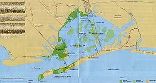
Jamaica Bay is an estuary on the southern portion of the western tip of Long Island, in the U.S. state of New York. The estuary is partially man-made, and partially natural. The bay connects with Lower New York Bay to the west, through Rockaway Inlet, and is the westernmost of the coastal lagoons on the south shore of Long Island. Politically, it is primarily divided between the boroughs of Brooklyn and Queens in New York City, with a small part touching Nassau County.
The American Museum of Natural History is a natural history museum on the Upper West Side of Manhattan in New York City. Located in Theodore Roosevelt Park, across the street from Central Park, the museum complex comprises 20 interconnected buildings housing 45 permanent exhibition halls, in addition to a planetarium and a library. The museum collections contain about 35 million specimens of plants, animals, fungi, fossils, minerals, rocks, meteorites, human remains, and human cultural artifacts, as well as specialized collections for frozen tissue and genomic and astrophysical data, of which only a small fraction can be displayed at any given time. The museum occupies more than 2,500,000 sq ft (232,258 m2). AMNH has a full-time scientific staff of 225, sponsors over 120 special field expeditions each year, and averages about five million visits annually.

St. George is a neighborhood on the northeastern tip of Staten Island in New York City, along the waterfront where the Kill Van Kull enters Upper New York Bay. It is the most densely developed neighborhood on Staten Island, and the location of the administrative center for the borough and for the coterminous Richmond County. The St. George Terminal, serving the Staten Island Ferry and the Staten Island Railway, is also located here. St. George is bordered on the south by the neighborhood of Tompkinsville and on the west by the neighborhood of New Brighton.
The history of New York City has been influenced by the prehistoric geological formation during the last glacial period of the territory that is today New York City. The area was long inhabited by the Lenape; after initial European exploration in the 16th century, the Dutch established New Amsterdam in 1626. In 1664, the British conquered the area and renamed it New York.
The Wildlife Conservation Society (WCS) is a 501(c)(3) non-governmental organization headquartered at the Bronx Zoo in New York City, that aims to conserve the world's largest wild places in 14 priority regions. Founded in 1895 as the New York Zoological Society (NYZS), the organization is now led by President and CEO, Monica P. Medina, who replaced long time President and CEO Cristián Samper in 2023. WCS manages four New York City wildlife parks in addition to the Bronx Zoo: the Central Park Zoo, New York Aquarium, Prospect Park Zoo and Queens Zoo. Together these parks receive 4 million visitors per year. All of the New York City facilities are accredited by the Association of Zoos and Aquariums (AZA).

Marcus Garvey Park is a 20.16-acre (81,600 m2) park on the border between the Harlem and East Harlem neighborhoods of Manhattan, New York City. The park, centered on a massive and steep outcropping of schist, interrupts the flow of Fifth Avenue traffic, which is routed around the park via Mount Morris Park West. The park is also bounded by 120th Street to the south, 124th Street to the north, and Madison Avenue to the east.

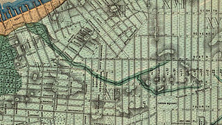
The Sawkill or Saw-kill was the largest hydrological network on Manhattan island in New York City before the Dutch colony of New Netherland was founded in 1624. This 44,980-foot-long (13,710 m) stream began "within four blocks of the Hudson River":
A rill flowing east from the rocky ridge overlooking Bloomingdale Village, which rose near Ninth Avenue and 85th Street, flowed in a southerly direction through Manhattan Square, where it spread into a little pond, and then turned east, crossing Central Park to Fifth Avenue, receiving three tributaries within its limits, two from the north and one from the south. At 75th Street near Third Avenue it was joined by another stream. Near this junction the old Boston Post Road crossed it, and then from this point, the stream ran due east to its outlet near the foot of 75th Street

Eric W. Sanderson is a landscape ecologist for the Wildlife Conservation Society at the Bronx Zoo, director of the Mannahatta Project and the author of Mannahatta: A Natural History of New York City. In 2013 Sanderson's book Terra Nova: The New World After Oil, Cars, and Suburbs was published.

The Whitehall Terminal is a ferry terminal in the South Ferry section of Lower Manhattan, New York City, at the corner of South Street and Whitehall Street. It is used by the Staten Island Ferry, which connects the island boroughs of Manhattan and Staten Island. The Whitehall Terminal is one of the ferry's two terminals, the other being St. George Terminal on Staten Island.

The Battery, formerly known as Battery Park, is a 25-acre (10 ha) public park located at the southern tip of Manhattan Island in New York City facing New York Harbor. It is bounded by Battery Place on the north, with Bowling Green to the northeast, State Street on the east, New York Harbor to the south, and the Hudson River to the west. The park contains attractions such as an early 19th-century fort named Castle Clinton; multiple monuments; and the SeaGlass Carousel. The surrounding area, known as South Ferry, contains multiple ferry terminals, including the Staten Island Ferry's Whitehall Terminal; a boat launch to the Statue of Liberty National Monument ; and a boat launch to Governors Island.

Minetta Creek was one of the largest natural watercourses in Manhattan, New York City, United States. Minetta Creek was fed from two tributaries, one originating at Fifth Avenue and 21st Street, and the other originating at Sixth Avenue and 16th Street. They joined near Fifth Avenue and 11th Street then took a southwesterly course. Minetta Creek's name is thought to have originated from either the Native American term "Manette", meaning "Devil's Water", or the Dutch word "Minnetje", meaning "the little one".
The land comprising New York City holds approximately 5.2 million trees and 168 different tree species, as of 2020. The New York City government, alongside an assortment of environmental organizations, actively work to plant and maintain the trees. As of 2020, New York City held 44,509 acres of urban tree canopy with 24% of its land covered in trees.

The expansion of the land area of Lower Manhattan in New York City by land reclamation has, over time, greatly altered Manhattan Island's shorelines on the Hudson and East rivers; as well as those of the Upper New York Bay. The extension of the island began with European colonialization and continued in the 20th century. Incremental encroachment as well as major infrastructure have added acreage to the island. Since the passage of the Rivers and Harbors Act of 1899 all projects which extend into navigable waterways follow federal regulation and are overseen by the United States Army Corps of Engineers. no

Lenape canoes were dugout canoes of Lenapehoking. Tree trunks used were primarily of the American tulip tree, and also of elm, white oak, chestnut or red cedar. Birch bark canoes were not used in the region.

NY400: Holland on the Hudson was the 2009 commemoration of the 400th anniversary of Henry Hudson's 1609 expedition up the river bearing his name, that later provided the basis for the founding of New Netherland. The peak of activity in New York City was NY400 Week, September 8-13. It was also the occasion for environmental thinking, including the Mannahatta Project reconstructing the ecology of 1609 Manhattan.
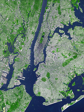
The environment of New York City consists of many interwoven ecosystems as part of the New York–New Jersey Harbor Estuary. The climate of New York City shapes the environment with its cool, wet winters and hot, humid summers with plentiful rainfall all year round. As of 2020, New York City held 44,509 acres of urban tree canopy with 24% of its land covered in trees. As of 2020, the population of New York City numbered 8.8 million human beings.
References
- ↑ Kimmelman, Michael (2020-05-13). "When Manhattan Was Mannahatta: A Stroll Through the Centuries". The New York Times. ISSN 0362-4331 . Retrieved 2022-04-04.
- ↑ "The Mannahatta Project". The New Yorker. 2007-09-24. Retrieved 2022-04-04.
- ↑ Sanderson, Eric (2009-09-11). "Opinion | After the Storms, an Island of Calm — and Resilience". The New York Times. ISSN 0362-4331 . Retrieved 2022-04-05.
- ↑ Sullivan, Robert (2009-05-22). "Island in the Stream". The New York Times. ISSN 0362-4331 . Retrieved 2022-04-04.
- ↑ "'Mannahatta/Manhattan' — Story". Pentagram. Retrieved 2022-04-05.
- ↑ "Mannahatta/Manhattan | Museum of the City of New York". www.mcny.org. Retrieved 2022-04-08.
- 1 2 Rothstein, Edward (2009-07-03). "Manhattan: An Island Always Diverse". The New York Times. ISSN 0362-4331 . Retrieved 2022-04-07.
- ↑ "The Welikia Project » Overview" . Retrieved 2022-04-04.
- ↑ "The Welikia Project » How it All Began" . Retrieved 2022-04-05.
- ↑ "The New York Public Library's Dorothy and Lewis B. Cullman Center for Scholars and Writers Announces 2019-2020 Fellows". The New York Public Library. Retrieved 2022-04-07.
- ↑ Magazine, Smithsonian; LeVay, Tony Perrottet,Gina. "How New York City Is Rediscovering Its Maritime Spirit". Smithsonian Magazine. Retrieved 2022-04-19.
{{cite web}}: CS1 maint: multiple names: authors list (link)