Related Research Articles
The BMT Brighton Line, also known as the Brighton Beach Line, is a rapid transit line in the B Division of the New York City Subway in Brooklyn, New York City, United States. Local service is provided at all times by the Q train, but is joined by the B express train on weekdays. The Q train runs the length of the entire line from Coney Island–Stillwell Avenue to the Manhattan Bridge south tracks. The B begins at Brighton Beach and runs via the bridge's north tracks.
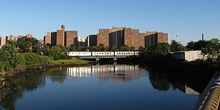
Coney Island Creek is a 1.8-mile-long (2.9 km) tidal inlet in Brooklyn, New York City. It used to be a 3-mile-long (4.8 km) continual strait and a partial mudflat connecting Gravesend Bay and Sheepshead Bay, making Coney Island an actual island, but the eastern half of the creek was filled in by land owners and city construction projects during a period spanning the early to mid 20th century.

Gravesend is a neighborhood in the south-central section of the New York City borough of Brooklyn, on the southwestern edge of Long Island in the U.S. state of New York. It is bounded on the south by Coney Island, on the west by Bath Beach, on the north by Bensonhurst, and on the east by Homecrest and Sheepshead Bay.
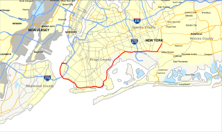
The Belt Parkway is the name given to a series of connected limited-access highways that form a belt-like circle around the New York City boroughs of Brooklyn and Queens. The Belt Parkway comprises three of the four parkways in what is known as the Belt System: the Shore Parkway, the Southern Parkway, and the Laurelton Parkway. The three parkways in the Belt Parkway are a combined 25.29 miles (40.70 km) in length. The Cross Island Parkway makes up the fourth parkway in the system, but is signed separately.

Sheepshead Bay is a neighborhood in southern Brooklyn, New York City. It is bounded by Ocean Parkway to the west; Avenue T and Kings Highway to the north; Nostrand Avenue and Gerritsen Avenue to the east; and the Atlantic Ocean to the south. Sheepshead Bay is abutted by the neighborhoods of Brighton Beach and Homecrest to the west; Midwood to the north; and Gerritsen Beach to the east.

Bay Parkway is a 2.7-mile (7.82 km) boulevard/parkway in the west portion of the New York City borough of Brooklyn.
Kings Highway is a broad avenue that curves about the southern part of the Borough of Brooklyn in New York City. Its west end is at Bay Parkway and 78th Street. East of Ocean Avenue, the street is largely residential. It tracks eastward, then northeast, then north through Brooklyn and reaches East 98th Street in central Brooklyn. At that point, it flows into Howard Avenue to provide seamless access to Eastern Parkway, another major road in Brooklyn with side medians and service roads.

Ocean Parkway is a 4.86-mile (7.82 km) boulevard in the west-central portion of the New York City borough of Brooklyn. It is inventoried by the New York State Department of Transportation (NYSDOT) as New York State Route 908H (NY 908H), an unsigned reference route.

Jacob Riis Park, also called Jacob A. Riis Park and Riis Park, is a seaside park on the southwestern portion of the Rockaway Peninsula in the New York City borough of Queens. It lies at the foot of the Marine Parkway–Gil Hodges Memorial Bridge, east of Fort Tilden, and west of Neponsit and Rockaway Beach. Originally run by the New York City Department of Parks and Recreation, it is now part of the Jamaica Bay Unit of the Gateway National Recreation Area, and is managed by the National Park Service (NPS). It features an extensive sand beach along the Atlantic Ocean coastline and several historic Art Deco structures.
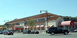
Lundy's Restaurant, also known as Lundy Brothers Restaurant, was an American seafood restaurant in the Sheepshead Bay neighborhood of Brooklyn, New York City, along the bay of the same name. Lundy's was founded in 1926 by Irving Lundy as a restaurant on the waterfront of Sheepshead Bay; five years later, the original building was condemned to make way for a redevelopment of the bay. The present building opened in 1934 or 1935, and closed in 1979. Another restaurant operated in the Lundy's building from 1997 to early 2007, after which the building was converted into a shopping center.

The B44 is a public transit line in Brooklyn, New York City, running mostly along Nostrand Avenue, as well as northbound on Rogers Avenue or New York Avenue and Bedford Avenue, between Sheepshead Bay and Williamsburg. Originally a streetcar line, it is now the B44 bus route, operated by the New York City Transit Authority.

The Manhattan Beach Branch, Manhattan Beach Line, or Manhattan Beach Division was a line of the Long Island Rail Road, running from Fresh Pond, Queens, south to Manhattan Beach, Brooklyn, New York City, United States. It opened in 1877 and 1878 as the main line of the New York and Manhattan Beach Railway. The tracks from Flatbush south to Manhattan Beach were removed from 1938 to 1941, while most of the rest is now the freight-only Bay Ridge Branch.

Gravesend Race Track at Gravesend in Brooklyn, New York was a Thoroughbred horse racing facility that opened in 1886 and closed in 1910. The track was built by the Brooklyn Jockey Club with the backing of Philip and Michael Dwyer, two wealthy racing stable owners known as the Dwyer Brothers. Philip, the controlling shareholder of the Brooklyn Jockey Club, served as its president.

Sheepshead Bay Race Track was an American Thoroughbred horse racing facility built on the site of the Coney Island Jockey Club at Sheepshead Bay, New York.

Plumb Beach is a beach and surrounding neighborhood along the north shore of Rockaway Inlet, in the New York City borough of Brooklyn. It is located near the neighborhoods of Sheepshead Bay and Gerritsen Beach, just off the Belt Parkway.
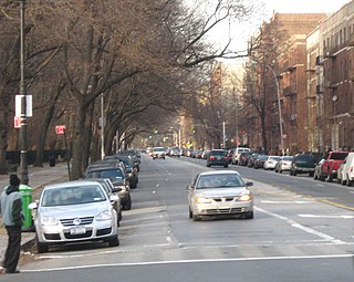
Ocean Avenue is a major street in Brooklyn, New York that runs generally north-south and occupies the position of East 20th Street in the Brooklyn street grid, with East 19th Street to its west and East 21st Street to its east for most of its path. It runs east of and parallel to Ocean Parkway and Coney Island Avenue for most of its route. Except for a short stretch on the Manhattan Beach peninsula, Ocean Avenue starts in the south at Emmons Avenue in Sheepshead Bay just south of the Belt Parkway and continues north, ending at Flatbush Avenue at Willink Plaza after running for several blocks as the eastern edge of Prospect Park. A footbridge across Sheepshead Bay connects the two "Ocean Avenue" sections.

Father Capodanno Boulevard, formerly Seaside Boulevard, is the primary north-south artery that runs through the Arrochar, South Beach, Ocean Breeze, Midland Beach, and New Dorp Beach neighborhoods of the New York City borough of Staten Island. The boulevard runs parallel to the South Beach Boardwalk and its public park.
Mall 211 is a series of nine traffic medians on 211th Street, between 99th Avenue and Hollis Avenue in the Bellaire section of the Queens Village neighborhood of Queens. When the Bellaire section was developed in 1907, a wide road connecting to the Bellaire station on the Long Island Rail Road was given a green median with nine traffic islands serving as a centerpiece of the planned suburban community. Bellaire Boulevard connected two historic roads that predate the neighborhood’s development, Jamaica Avenue and Hollis Avenue.

Spring Creek Park is a public park along the Jamaica Bay shoreline between the neighborhoods of Howard Beach, Queens, and Spring Creek, Brooklyn, in New York City. Created on landfilled former marshland, the park is mostly an undeveloped nature preserve, with only small portions accessible to the public for recreation.
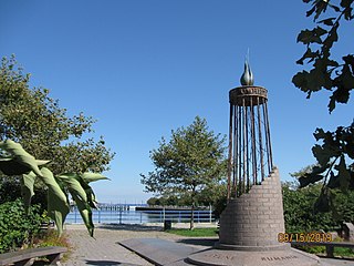
The Holocaust Memorial Park is a public Holocaust memorial park located at the water's edge between Emmons Avenue and Shore Boulevard in Sheepshead Bay Brooklyn. The nearby communities of Sheepshead Bay, Manhattan Beach, and Brighton Beach were settled after World War II by a large Jewish population, many of whom were immigrants and survivors of the Holocaust.
References
- ↑ “Manhattan Beach to be an Ideal Home Colony” Brooklyn Daily Eagle June 23, 1907
- ↑ “Transactions in Realty and Building Developments” Brooklyn Daily Eagle August 21, 1911
- ↑ "Ocean Avenue Bridge, Sheepshead Bay". Forgotten New York. April 25, 2015. Retrieved January 20, 2016.