List of bridges and tunnels in New York City

Last updated

The Manhattan Bridge and Brooklyn Bridge on the East River in 1981 Manhattan and Brooklyn bridges on the East River, New York City, 1981.jpg
The Manhattan Bridge and Brooklyn Bridge on the East River in 1981

New York City is home to 789 bridges and tunnels.

Several agencies manage this network of crossings. The New York City Department of Transportation owns and operates almost 800. [1] The Metropolitan Transportation Authority, Port Authority of New York and New Jersey, New York State Department of Transportation and Amtrak have many others.

Contents

Many of the city's major bridges and tunnels have broken or set records. Opened in 1927, the Holland Tunnel was the world's first mechanically ventilated underwater vehicular tunnel. The Brooklyn Bridge, Williamsburg Bridge, George Washington Bridge, and Verrazzano-Narrows Bridge were the world's longest suspension bridges when opened in 1883, [2] 1903, [3] 1931, [4] and 1964 [5] respectively.

Bridges

South Street Seaport, with Brooklyn Bridge, Manhattan Bridge, and Williamsburg Bridge visible in background South Street Seaport2.jpg
South Street Seaport, with Brooklyn Bridge, Manhattan Bridge, and Williamsburg Bridge visible in background

New York City's water crossings date back to 1693, when its first bridge, known as the King's Bridge, was constructed over Spuyten Duyvil Creek between Manhattan and the Bronx, located in the present-day Kingsbridge neighborhood. The bridge, composed of stone abutments and a timber deck, was demolished in 1917. The oldest crossing still standing is High Bridge, built in 1848. This bridge carried the water of the Croton Aqueduct over the Harlem River to the city as part of the Croton Aqueduct system. [6]

Ten bridges and one tunnel serving the city have been awarded some level of landmark status. The Holland Tunnel was designated a National Historic Landmark in 1993 in recognition of its pioneering role as the first mechanically ventilated vehicular underwater tunnel, operating since 1927. The George Washington, High, Hell Gate, Queensboro, Brooklyn, Manhattan, Macombs Dam, Carroll Street, University Heights, and Washington Bridges have all received landmark status, as well. [6]

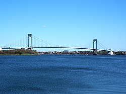
New York features bridges of many lengths and types, carrying vehicular, bicycle, pedestrian, and subway traffic. The George Washington Bridge, spanning the Hudson River between New York City and Fort Lee, New Jersey, is the world's busiest bridge in terms of vehicular traffic. [7] [8] The George Washington, Verrazzano-Narrows, and Brooklyn Bridges are noted for their architecture, while others are more well known for their functional importance, such as the Williamsburg Bridge with 8 vehicular lanes, 2 subway tracks, a bike lane, and pedestrian walkways.

Bridges by body of water

East River

From south to north:

NameOpening yearLengthCarriesNotesImageRef.
feetmeters
Brooklyn Bridge 18835,9881,8255 lanes of roadway (2 Manhattan-bound, 3 Brooklyn-bound)Oldest suspension bridge in NYC. Also oldest suspension/cable-stayed hybrid bridge. Brooklyn Bridge Manhattan.jpg
Manhattan Bridge 19096,8542,0897 lanes of roadway and NYCS-bull-trans-B-Std.svg NYCS-bull-trans-D-Std.svg NYCS-bull-trans-N-Std.svg NYCS-bull-trans-Q-Std.svg trainsDouble-decker bridge with 5 westbound lanes and 2 eastbound lanes.
3 of the westbound lanes and the subway are below the other 4 lanes.
Manhattan Bridge 2007.jpg
Williamsburg Bridge 19037,308.02,227.488 lanes of roadway (4 in each direction) and NYCS-bull-trans-J-Std.svg NYCS-bull-trans-M-Std.svg NYCS-bull-trans-Z-Std.svg trains Williamsburg Bridge full.jpg
Queensboro Bridge 19093,7241,1359 lanes of NY-25.svg NY 25 (Queens Boulevard)
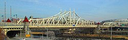
Officially known as the Ed Koch Queensboro Bridge. Also known as 59th Street Bridge.
Reversible 4 lanes on the upper deck, and 2 westbound/3 eastbound lanes on the lower deck.
Queensboro Bridge from Manhattan side.jpg
Roosevelt Island Bridge 19552,877.0876.912 lanes of roadway (1 in each direction)East channel only Roosevelt Island Bridge from the south (41860).jpg
Triborough Bridge (Suspension Bridge)19362,7908508 lanes of I-278.svg I-278 (4 in each direction)Officially known as the Robert F. Kennedy Bridge RFK Triboro Lift Bridge 20070902-jag9889.jpg
Hell Gate Bridge 19161,0203103 rail tracks (2 of Northeast Corridor, 1 of New York Connecting Railroad) Hell Gate Bridge (60275p).jpg
Rikers Island Bridge 19664,200.01,280.162 lanes of roadwayOnly connects Rikers Island to Queens RikerVlcsnap-2024-10-06-23h05m08s196.png
Bronx–Whitestone Bridge 19393,770.01,149.106 lanes of I-678.svg I-678 (Whitestone Expressway) Whitestone Bridge from Clason Point Park.jpg
Throgs Neck Bridge 19612,910.0886.976 lanes of I-295.svg I-295 (Throgs Neck Expressway) ThrogsNeckBridge.jpg

Harlem River

From south to north, east to west:

NameOpening yearLengthCarriesNotesImage
feetmeters
Wards Island Bridge 1951937285.6Pedestrians and bicycles only Ward's Island Bridge, New York City.JPG
Triborough Bridge (Vertical-Lift Bridge)19367502302 lanes of exit ramp from F.D.R. Drive Officially known as the Robert F. Kennedy Bridge RFK Triboro Lift Bridge 20070902-jag9889.jpg
Willis Avenue Bridge 19013,2129794 lanes of roadwayNorthbound traffic only Willis Av Bridge from HRLB late PM jeh.jpg
Third Avenue Bridge 18982,800.0853.445 lanes of roadwaySouthbound traffic only NYC Third Avenue Bridge.jpg
Park Avenue Bridge 19563301004 tracks of Metro-North ParkAveBrHarlem.JPG
Madison Avenue Bridge 19101,8935774 lanes of roadway Madison Avenue Bridge.jpg
145th Street Bridge 19051,6044894 lanes of roadway NYC 145th Street Bridge.jpg
Macombs Dam Bridge 18952,5397744 lanes of roadway Macombs Dam Bridge from Adam Clayton Powell Jr. Blvd approach.jpg
High Bridge 18482,000600Pedestrian walkway and bicycle lanesOldest surviving bridge in New York City A bridge in New York City.jpg
Alexander Hamilton Bridge 19632,3757248 lanes of I-95.svg I-95 and US 1.svg US 1 Alexander Hamilton Bridge from river jeh.jpg
Washington Bridge 18882,375723.96 lanes of roadway Wash Br Harlem water jeh.JPG
University Heights Bridge 1908269822 lanes of roadway 2014 University Heights Bridge from University Heights train station.jpg
Broadway Bridge 1962558.0170.084 lanes of Broadway/ US 9.svg US 9 and the NYCS-bull-trans-1-Std.svg trainAlso known as Harlem Ship Canal Bridge NYC Broadway Bridge.jpg
Henry Hudson Bridge 19362,2086736 lanes of NY-9A.svgHenry Hudson Pkwy Shield free.svg NY 9A  / Henry Hudson Parkway Double-decked bridge Henry Hudson Bridge 20171010-jag9889.jpg
Spuyten Duyvil Bridge 18996101861 track of Empire Corridor Swing bridge Circle Line crossing open Spuyten Duyvil Bridge crop.jpg

Hudson River

NameOpening yearLengthCarriesCommentsPhoto
feetmeters
George Washington Bridge 19314,760.01,450.8514 lanes of I-95.svgUS 1.svgUS 9.svgUS 46.svg I-95  / US 1  / US 9  / US 46 Double-deck, 8 lanes on upper level, 6 lanes on lower level. 7 lanes in each direction. George Washington Bridge, HAER NY-129-28.jpg

New York Bay

NameOpening yearLengthCarriesCommentsPhoto
feetmeters
Verrazzano-Narrows Bridge 196413,7014,17613 lanes of I-278.svg I-278 Double-deck, 7 lanes on upper level; 3 in each direction and 1 reversible HOV 3+ lane. 6 lanes on lower level; three in each direction. NYC Verrazano-Narrows Bridge 1.jpg

Newtown Creek

NameOpening yearLengthCarriesCommentsImage
feetmeters
Kosciuszko Bridge 2017, 20196,0201,8356 lanes of I-278.svg I-278 Eastbound span opened in April 2017, and westbound span opened in August 2019. It replaces the original bridge Kosciuszko Bridge 2017-02a jeh.jpg
Pulaski Bridge 19542,8208606 lanes of McGuinness Boulevard Drawbridge Pulaski Bridge from west jeh.JPG
Greenpoint Avenue Bridge 1987 [9] 180554 lanes of Greenpoint Avenuea.k.a. J. J. Byrne Memorial Bridge
Drawbridge
Greenpoint Av Bridge from below in Brooklyn jeh.jpg
Grand Street Bridge 1903 [9] 22769.21 lane of Grand Avenue Swing bridge; one-lane bridge Grand Street Bridge 2021.jpg
Metropolitan Avenue Bridge1933 [9] 11133.84 lanes of Grand Street and Metropolitan Avenue Drawbridge; Crosses English Kills, a tributary of Newtown Creek [9] Metropolitan Avenue Bridge from northwest jeh.jpg

Other

The Bronx

NameOpening yearLengthCarriesComments
Bronx Kill
Robert F. Kennedy Bridge 19361,610 feet (490 m)8 lanes of I-278.svg I-278 Formerly known as the Triborough Bridge
Hutchinson River (heading downriver)
Eastchester Bridge19260.4 miles4 lanes of Boston Road (US 1.svg US 1)
I-95 bridge19615,280 feet6 lanes of I-95.svg I-95
Hutchinson River Parkway Bridge1941673 feet (205 m)6 lanes of Hutchinson River Pkwy Shield.svg Hutchinson River Parkway Drawbridge
Pelham Bay Bridge 190881 feet (25 m) Northeast Corridor (Amtrak)Also called Amtrak Pelham Bay Bridge
Pelham Bridge 1908892 feet (272 m)4 lanes of Shore RoadDrawbridge
Westchester Creek
Unionport Bridge1953526 feet (160.3 m)7 lanes of I-278.svgI-95.svg I-278 ( Bruckner Boulevard ) / I-95
Bronx River
Eastern Boulevard Bridge1953634 feet (193.2 m)I-278.svg I-278 Drawbridge
Eastchester Bay
City Island Bridge 1901950 feet (290 m)3 lanes of City Island Avenue CI Bridge from south of park jeh.jpg

Brooklyn

NameOpening yearLengthCarriesCommentsImage
Gowanus Canal
Union Street Bridge1905 [10] 600 feet2 lanes of Union StreetDrawbridge
Carroll Street Bridge 1889 [10] 300 feet2 lanes of Carroll StreetNew York City Designated Landmark and one of four retractable bridges in the country [11]
The Carroll Street Bridge in Gowanus, Brooklyn Carroll Street Bridge.jpg
The Carroll Street Bridge in Gowanus, Brooklyn
Third Street Bridge1905 [10] 350 feetThird Street
Ninth Street Bridge1999 [10] 700 feetNinth StreetVertical Lift Bridge
Ninth Street Bridge, spanning Gowanus Canal in Brooklyn NYCS IND Culver GowanusCanalBridge.jpg
Ninth Street Bridge, spanning Gowanus Canal in Brooklyn
Culver Viaduct 1933 [12] 0.6 miles NYCS-bull-trans-F-Std.svg NYCS-bull-trans-Fd-Std.svg NYCS-bull-trans-G-Std.svg trainspasses over the Ninth Street Bridge, carrying 4 tracks, 2 express and 2 local
Ninth Street Bridge, spanning Gowanus Canal in Brooklyn NYCS IND Culver GowanusCanalBridge.jpg
Ninth Street Bridge, spanning Gowanus Canal in Brooklyn
Hamilton Avenue Bridge1942 [10] 0.7 milesHamilton Avenuepasses under the Gowanus Expressway and carries four lanes of traffic in each direction
A view facing west from the edge of the Hamilton Ave bride in Brooklyn, with the Gowanus expressway above HamiltonDSC02008.jpg
A view facing west from the edge of the Hamilton Ave bride in Brooklyn, with the Gowanus expressway above
Gowanus Expressway 1941 [13] 9 lanes of I-278.svg I-278 (Gowanus Expressway)
Mill Basin
Mill Basin Bridge 20176 lanes of Belt Pkwy Shield free.svg Belt Parkway The bridge has a combined bicycle and pedestrian pathway on the eastbound side of the bridge which carries the Jamaica Bay Greenway
Mill Basin Drawbridge

(demolished)

1940825 ft6 lanes of Belt Pkwy Shield free.svg Belt Parkway Twin-leaf bascule bridge; demolished in 2018 and replaced by Mill Basin Bridge
Rockaway Inlet (Brooklyn and Queens)
Marine Parkway–Gil Hodges Memorial Bridge 19371226 m4 lanes of Flatbush Avenue also has a narrow combined bicycle and pedestrian path on the southbound side of the bridge MarineParkwayBridgeOfficial.jpg

Queens

NameOpening yearLengthCarriesCommentsImage
Dutch Kills
Borden Avenue Bridge 1908 [9] 100 feet2 lanes of Borden AvenueOne of four retractable bridges in the country [11] Borden Avenue Bridge over Dutch Kills slide tracks jeh.jpg
Hunters Point Avenue Bridge1910 [9] 500 feetHunters Point Avenue
Cabin M Bridge1 track of the Montauk Cutoff There is another abandoned track on the bridge
DB Cabin Bridge1 track of the Montauk Branch The bridge was originally built to carry three tracks
Jamaica Bay
Cross Bay Veterans Memorial Bridge 19700.7 miles6 lanes Cross Bay Boulevard
Joseph P. Addabbo Memorial Bridge 19710.7 miles6 lanes of Cross Bay Boulevard
North Channel Swing Bridge NYCS-bull-trans-A-Std.svg trainNot actually a movable bridge.
Howard Beach to Broad Channel.
Beach Channel Drawbridge NYCS-bull-trans-A-Std.svg NYCS-bull-trans-S-Std.svg trains Broad Channel to The Rockaways
102nd Street Bridge Connecting Hamilton Beach at Russell Street with Howard Beach, also known as "Lenihan's Bridge".
Hawtree Creek Bridge 163rd Avenue and 99th Street in Howard Beach across to Hamilton Beach at Rau Court and Davenport CourtAlso known as "Joel Miele Sr. Bridge".
Rockaway Inlet (Brooklyn and Queens)
Marine Parkway-Gil Hodges Memorial Bridge 19371226 m4 lanes of Flatbush Avenue

Staten Island

NameOpening yearLengthCarriesComments
Arthur Kill
Goethals Bridge 2018 [14] [15] 2225.04 m6 lanes of I-278.svg I-278 Replaced the old Goethals Bridge (completed 1928); the two new spans are a cable-stayed design
Arthur Kill Vertical Lift Bridge 1959170.08 m CSX and M&E rail lines
Outerbridge Crossing 19283093 m4 lanes of Ellipse sign 440.svg Route 440; NY-440.svg NY 440
Kill Van Kull
Bayonne Bridge 19311761.74 m4 lanes of NY-440.svg NY 440; Ellipse sign 440.svg Route 440 raised and rebuilt in 2019

Tunnels

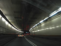
Each of the tunnels that run underneath the East and Hudson Rivers were marvels of engineering when first constructed. The Holland Tunnel is the oldest of the vehicular tunnels, opening to great fanfare in 1927 as the first mechanically ventilated underwater tunnel. The Queens Midtown Tunnel was opened in 1940 to relieve the congestion on the city's bridges. Each of its tubes were designed 1.5 feet (0.46 m) wider than the Holland Tunnel in order to accommodate the wider cars of the period. When the Brooklyn–Battery Tunnel opened in 1950, it was the longest continuous underwater vehicular tunnel in North America, a title it still holds. [16] The Lincoln Tunnel has three tubes linking midtown Manhattan to New Jersey, a configuration that provides the flexibility to provide four lanes in one direction during rush hours, or three lanes in both direction.

All four underwater road tunnels were built by Ole Singstad: the Holland Tunnel's original chief engineer Clifford Milburn Holland died, as did his successor, Milton H. Freeman, after which Singstad became chief engineer, finishing the Holland Tunnel and then building the remaining tunnels.

East River

From south to north:

NameOpening yearLengthCarriesCommentsImage
Brooklyn–Battery Tunnel 19502,779 m (9,117 ft)4 lanes of I-478.svg I-478 Officially known as the Hugh L. Carey Tunnel Brooklyn Battery Tunnel Portal Building.jpg
Joralemon Street Tunnel 19082,709 m (8,888 ft) NYCS-bull-trans-4-Std.svg NYCS-bull-trans-5-Std.svg trains Joralemon Street Tunnel postcard, 1913.jpg
Montague Street Tunnel 19202,136 m (7,009 ft) NYCS-bull-trans-N-Std.svg NYCS-bull-trans-R-Std.svg NYCS-bull-trans-W-Std.svg trains
Clark Street Tunnel 19191,800 m (5,900 ft) NYCS-bull-trans-2-Std.svg NYCS-bull-trans-3-Std.svg trains
Cranberry Street Tunnel 1933 NYCS-bull-trans-A-Std.svg NYCS-bull-trans-C-Std.svg trains
Rutgers Street Tunnel 1936 NYCS-bull-trans-F-Std.svg NYCS-bull-trans-Fd-Std.svg trains
14th Street Tunnel 1924 NYCS-bull-trans-L-Std.svg train
East River Tunnels 19101,204 m (3,949 ft)part of the New York Tunnel Extension
Amtrak and Long Island Rail Road (Northeast Corridor)
Queens–Midtown Tunnel 19401,955 m (6,414 ft)4 lanes of I-495.svg I-495 ( Long Island Expressway )
The Queens-Midtown Tunnel Midtown Tunnel.JPG
The Queens–Midtown Tunnel
Steinway Tunnel 1915 NYCS-bull-trans-7-Std.svg NYCS-bull-trans-7d-Std.svg trains
53rd Street Tunnel 1933 NYCS-bull-trans-E-Std.svg NYCS-bull-trans-M-Std.svg trains
60th Street Tunnel 1920 NYCS-bull-trans-N-Std.svg NYCS-bull-trans-R-Std.svg NYCS-bull-trans-W-Std.svg trains
63rd Street Tunnel 1989960 m (3,140 ft)Upper level: NYCS-bull-trans-F-Std.svg NYCS-bull-trans-Fd-Std.svg trains
Lower level: LIRR to Grand Central Madison
Ravenswood Tunnel 1892Electricity, natural gas, steam, and number 6 fuel oilFirst tunnel under the East River and Roosevelt Island, between Big Allis power plant in Astoria and Upper East Side [17] [18]

Harlem River

From south to north:

NameOpening yearLengthCarriesComments
Lexington Avenue Tunnel 1918391 m (1,283 ft) NYCS-bull-trans-4-Std.svg NYCS-bull-trans-5-Std.svg NYCS-bull-trans-6-Std.svg NYCS-bull-trans-6d-Std.svg trains
149th Street Tunnel 1905195 m (641 ft) NYCS-bull-trans-2-Std.svg train
Concourse Tunnel 1933 NYCS-bull-trans-B-Std.svg NYCS-bull-trans-D-Std.svg trains

Hudson River

From south to north:

NameOpening yearLengthCarriesCommentsImage
Downtown Hudson Tubes 19091,720 m (5,650 ft)Montgomery-Cortlandt Tunnels
Port Authority Trans-Hudson
PATH train emerging from the Hudson tubes, into the Exchange Place station Jersey-city-exchange-place-platform.jpg
PATH train emerging from the Hudson tubes, into the Exchange Place station
Holland Tunnel 1927south tube: 2,551 m (8,371 ft)
north tube: 2,608 m (8,558 ft)
4 lanes of I-78.svg I-78 (Canal Street); Ellipse sign 139.svg Route 139 (NJ side)
Traveling through the Holland Tunnel, from Manhattan to Jersey City, New Jersey Holland tunnel.jpg
Traveling through the Holland Tunnel, from Manhattan to Jersey City, New Jersey
Uptown Hudson Tubes 19081,700 m (5,500 ft)Hoboken-Morton Tunnels
Port Authority Trans-Hudson
North River Tunnels 19101,900 m (6,100 ft)part of New York Tunnel Extension
Amtrak and New Jersey Transit (Northeast Corridor)
NJT NEC enters Hudson Palisades.jpg
Lincoln Tunnel north tube: 1945
center tube: 1937
south tube: 1957
south tube: 2,440 m (8,006 ft)
center tube: 2,504 m (8,216 ft)
north tube: 2,281 m (7,482 ft)
6 lanes of NY-495.svg NY 495 (NY side); Ellipse sign 495.svg Route 495 (NJ side) 2018-07-08 10 45 46 View east along New Jersey State Route 495 (Lincoln Tunnel Approach) at the western entrance of the Lincoln Tunnel in Weehawken Township, Hudson County, New Jersey.jpg

Newtown Creek

NameOpening yearCarriesComments
Greenpoint Tube 1933 NYCS-bull-trans-G-Std.svg train

Bridges and tunnels spanning land only

See also

References

  1. "NYC DOT – Bridges". www1.nyc.gov. Retrieved February 20, 2022.
  2. "NYC DOT – Brooklyn Bridge" . Retrieved February 24, 2012.
  3. "NYC DOT – Williamsburg Bridge" . Retrieved February 24, 2012.
  4. "History – George Washington Bridge – The Port Authority of NY & NJ" . Retrieved February 24, 2012.
  5. "Verrazano-Narrows Bridge" . Retrieved February 24, 2012.
  6. 1 2 "NYC DOT – Frequently Asked Questions about Bridges" . Retrieved February 24, 2012.
  7. "Port Authority of New York and New Jersey - George Washington Bridge". The Port Authority of New York & New Jersey. Retrieved September 13, 2013.
  8. Bod Woodruff; Lana Zak & Stephanie Wash (November 20, 2012). "GW Bridge Painters: Dangerous Job on Top of the World's Busiest Bridge". ABC News. Retrieved September 13, 2013.
  9. 1 2 3 4 5 6 "Movable Bridges over Newtown Creek and its Tributaries". New York City. Retrieved September 20, 2013.
  10. 1 2 3 4 5 New York City Dept. of Transportation. "Bridges over the Gowanus Canal". New York City. Retrieved September 20, 2013.
  11. 1 2 Berger, Joseph (May 13, 2013). "Antique Bridge Closed to Traffic While It's Open for Repairs". New York Times. Retrieved July 1, 2018.
  12. "City Subway Extended". The New York Times. October 7, 1933. p. 16. ISSN   0362-4331 . Retrieved December 18, 2018.
  13. "Gowanus Expressway". nycroads.com. Retrieved July 1, 2018.
  14. Porpora, Tracey (June 11, 2017). "Goethals Bridge now open in both directions". SILive.com. Retrieved June 12, 2017.
  15. Grunlund, Maura (May 21, 2018). "First a.m. rush hour for new Goethals Bridge to New Jersey". SILive.com. Retrieved May 21, 2018.
  16. "Hugh L. Carey Tunnel (formerly Brooklyn-Battery Tunnel)". MTA Bridges & Tunnels. Retrieved December 2, 2015.
  17. Tunnel Under The East River
  18. How the First East River Tunnel was built
  19. Daley, Suzanne (May 22, 1985). "Rebuilding the Riverside Drive Viaduct". The New York Times. Retrieved August 12, 2024.