The Robert F. Kennedy Bridge is a complex of bridges and elevated expressway viaducts in New York City. The bridges link the boroughs of Manhattan, Queens, and the Bronx. The viaducts cross Randalls and Wards Islands, previously two islands and now joined by landfill.
The Harlem River is an 8-mile (13 km) tidal strait in New York City, New York, flowing between the Hudson River and the East River and separating the island of Manhattan from the Bronx on the United States mainland.

The Hell Gate Bridge is a railroad bridge in New York City, New York, United States. The bridge carries two tracks of Amtrak's Northeast Corridor and one freight track between Astoria, Queens, and Port Morris, Bronx, via Randalls and Wards Islands. Its main span is a 1,017-foot (310 m) steel through arch across Hell Gate, a strait of the East River that separates Wards Island from Queens. The bridge also includes several approach viaducts and two spans across smaller waterways. Including approaches, the bridge is 17,000 feet (5,200 m) long. It is one of the few rail connections from Long Island, of which Queens is part, to the rest of the United States.

Harlem–125th Street station is a commuter rail stop serving the Metro-North Railroad's Hudson, Harlem, and New Haven Lines. It is located at East 125th Street and Park Avenue in East Harlem, Manhattan, New York City. The station also serves as an important transfer point between the Metro-North trains and the New York City Subway's IRT Lexington Avenue Line for access to the Upper East Side of Manhattan. It is the only station besides Grand Central Terminal that serves all three lines east of the Hudson River. Trains leave for Grand Central Terminal, as well as to the Bronx and the northern suburbs, regularly.

The Broadway Bridge is a vertical-lift bridge across the Harlem River Ship Canal in the borough of Manhattan in New York City. It connects the neighborhoods of Inwood on Manhattan Island and Marble Hill on the mainland. The bridge consists of two decks. The lower deck carries Broadway, which is designated as U.S. Route 9 at this location. The upper deck carries the New York City Subway's IRT Broadway–Seventh Avenue Line, serving the 1 train.

The 125th Street station is an elevated local station on the IRT Broadway–Seventh Avenue Line of the New York City Subway. Located at the intersection of 125th Street and Broadway, at the border of the Manhattanville and Morningside Heights neighborhoods of Manhattan, it is served by the 1 train at all times.
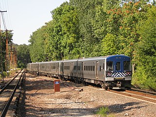
The Harlem Line is an 82-mile (132 km) commuter rail line owned and operated by the Metro-North Railroad in the U.S. state of New York. It runs north from New York City to Wassaic, in eastern Dutchess County. The lower 53 miles (85 km) from Grand Central Terminal to Southeast, in Putnam County, is electrified with a third rail and has at least two tracks. The section north of Southeast is a non-electrified single-track line served by diesel locomotives. Before the renaming of the line in 1983, it eventually became the Harlem Division of the New York Central Railroad. The diesel trains usually run as a shuttle on the northern end of the line, except for rush-hour express trains in the peak direction.

The West Side Line, also called the West Side Freight Line, is a railroad line on the west side of the New York City borough of Manhattan. North of Penn Station, from 34th Street, the line is used by Amtrak passenger service heading north via Albany to Toronto; Montreal; Niagara Falls and Buffalo, New York; Burlington, Vermont; and Chicago. South of Penn Station, a 1.45-mile (2.33 km) elevated section of the line, abandoned since 1980, has been transformed into an elevated park called the High Line. The south section of the park from Gansevoort Street to 20th Street opened in 2009 and the second section up to 30th Street opened in 2011, while the final section to 34th Street opened in 2014.
The Macombs Dam Bridge is a swing bridge across the Harlem River in New York City, connecting the boroughs of Manhattan and the Bronx. The bridge is operated and maintained by the New York City Department of Transportation (NYCDOT).

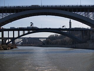
The Washington Bridge is a 2,375-foot (724 m)-long arch bridge over the Harlem River in New York City between the boroughs of Manhattan and the Bronx. The crossing, opened in 1888, connects 181st Street and Amsterdam Avenue in Washington Heights, Manhattan, with University Avenue in Morris Heights, Bronx. It carries six lanes of traffic, as well as sidewalks on both sides. Ramps at either end of the bridge connect to the Trans-Manhattan Expressway and the Cross Bronx Expressway, and serves as a connector/highway to the highway itself.

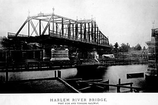
The University Heights Bridge is a steel-truss revolving swing bridge across the Harlem River in New York City. It connects West 207th Street in the Inwood neighborhood of Manhattan with West Fordham Road in the University Heights neighborhood of the Bronx. The bridge is operated and maintained by the New York City Department of Transportation.

The Fourteenth Street Bridge, also known as the Ohio Falls Bridge, Pennsylvania Railroad Bridge, Conrail Railroad Bridge or Louisville and Indiana (L&I) Bridge, is a truss drawbridge that spans the Ohio River, between Louisville, Kentucky and Clarksville, Indiana.

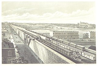
The Park Avenue main line, which consists of the Park Avenue Tunnel and the Park Avenue Viaduct, is a railroad line in the New York City borough of Manhattan, running entirely along Park Avenue. The line carries four tracks of the Metro-North Railroad as a tunnel from Grand Central Terminal at 42nd Street to a portal at 97th Street, where it rises to a viaduct north of 99th Street and continues over the Harlem River into the Bronx over the Park Avenue Bridge. During rush hours, Metro-North uses three of the four tracks in the peak direction.
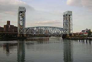
The Putnam Bridge was a swing bridge that spanned the Harlem River and the adjacent tracks of the New York Central Railroad in New York City. The bridge connected Harlem in Manhattan to Concourse, near the current location of Yankee Stadium, in the Bronx. It carried two tracks of the New York and Putnam Railroad, and later the 9th Avenue elevated line of the Interborough Rapid Transit Company (IRT), as well as two pedestrian walkways outside the superstructure.

The 59th Street station is a never-opened station in the Park Avenue Tunnel used by the Metro-North Railroad. The station was built by the New York Central & Hudson River Railroad as part of an agreement with the government of New York City during the late 1870s, although trains never stopped here. The station is used as an emergency exit for the Metro-North Railroad.
The 110th Street station was a station located on the Metro-North Railroad's Park Avenue Viaduct in East Harlem, Manhattan, New York City. The station was built by the New York Central & Hudson River Railroad as part of an agreement with the New York City government. It was located at Park Avenue and 110th Street.

The 72nd Street station is an abandoned station located in the Park Avenue Tunnel used by Metro-North Railroad. The station has two side platforms and is located in between 72nd Street and 73rd Street underneath Park Avenue on the Upper East Side of Manhattan. The station was built by the New York Central & Hudson River Railroad as part of an agreement with New York City.

The 86th Street station is an abandoned station located in the Park Avenue Tunnel used by Metro-North Railroad. The station was built by the New York Central & Hudson River Railroad as part of an agreement with New York City. The station was built during the late 19th century. It was located at Park Avenue and 86th Street on the Upper East Side of Manhattan.

Grand Central Terminal is a major commuter rail terminal in Midtown Manhattan, New York City, serving the Metro-North Railroad's Harlem, Hudson and New Haven Lines. It is the most recent of three functionally similar buildings on the same site. The current structure was built by and named for the New York Central & Hudson River Railroad, though it also served the New York, New Haven and Hartford Railroad. Passenger service has continued under the successors of the New York Central and New Haven railroads.