The Bronx River Parkway is a 19.12-mile (30.77 km) limited-access parkway in downstate New York in the United States. It is named for the nearby Bronx River, which it parallels. The southern terminus of the parkway is at Story Avenue near the Bruckner Expressway in the Bronx neighborhood of Soundview. The northern terminus is at Kensico Circle in North Castle, Westchester County, where the parkway connects to the Taconic State Parkway and via a short connector, New York State Route 22 (NY 22). Within the Bronx, the parkway is maintained by the New York State Department of Transportation and is designated New York State Route 907H (NY 907H), an unsigned reference route. In Westchester County, the parkway is maintained by the Westchester County Department of Public Works and is designated unsigned County Route 9987 (CR 9987).

Fordham station, also known as Fordham–East 190th Street station, is a commuter rail stop on the Metro-North Railroad's Harlem and New Haven Lines, serving Fordham Plaza in the Fordham neighborhood of the Bronx, New York City. The platforms are situated just below street level and feature two expanded side platforms that serve eight cars each, on the outer tracks. The station building sits above the tracks on the Fordham Road overpass, and still bears the name New York Central Railroad on its facade. The station is among the busiest rail stations in the Bronx.
The Macombs Dam Bridge is a swing bridge across the Harlem River in New York City, connecting the boroughs of Manhattan and the Bronx. The bridge is operated and maintained by the New York City Department of Transportation (NYCDOT).

Harlem River Drive is a 4.20-mile (6.76 km) controlled-access parkway in the New York City borough of Manhattan. It runs along the west bank of the Harlem River from the Triborough Bridge in East Harlem to 10th Avenue in Inwood, where the parkway ends and the road continues northwest as Dyckman Street. South of the Triborough Bridge, the parkway continues toward lower Manhattan as FDR Drive. All of Harlem River Drive is designated New York State Route 907P (NY 907P), an unsigned reference route.

The Alexander Hamilton Bridge is an eight-lane steel arch bridge that carries traffic over the Harlem River between the boroughs of Manhattan and the Bronx in New York City. The bridge connects the Trans-Manhattan Expressway in the Washington Heights section of Manhattan with the Cross Bronx Expressway as part of Interstate 95 and U.S. 1.

The Washington Bridge is a 2,375-foot (724 m)-long arch bridge over the Harlem River in New York City between the boroughs of Manhattan and the Bronx. The crossing, opened in 1888, connects 181st Street and Amsterdam Avenue in Washington Heights, Manhattan, with University Avenue in Morris Heights, Bronx. It carries six lanes of traffic, as well as sidewalks on both sides. Ramps at either end of the bridge connect to the Trans-Manhattan Expressway and the Cross Bronx Expressway, and serves as a connector/highway to the highway itself.

Transportation Alternatives is a non-profit organization in New York City which works to change New York City's transportation priorities to encourage and increase non-polluting, quiet, city-friendly travel and decrease automobile use. TransAlt seeks a transportation system based on a "Green Transportation Hierarchy" giving preference to modes of travel based on their relative benefits and costs to society. To achieve these goals, T.A. works in five areas: Cycling, Walking and Traffic Calming, Car-Free Parks, Safe Streets and Sustainable Transportation. Promotional activities include large group bicycle rides.

Interstate 95 (I-95) is part of the Interstate Highway System and runs from Miami, Florida, to the Canada–United States border near Houlton, Maine. In the US state of New York, I-95 extends 23.50 miles (37.82 km) from the George Washington Bridge in New York City to the Connecticut state line at Port Chester. The George Washington Bridge carries I-95 across the Hudson River from New Jersey into New York City. There, I-95 runs across Upper Manhattan on the Trans-Manhattan Expressway for 0.81 miles (1.30 km) through Washington Heights. It continues east across the Harlem River on the Alexander Hamilton Bridge and onto the Cross Bronx Expressway. In the Bronx, I-95 leaves the Cross Bronx at the Bruckner Interchange, joining the Bruckner Expressway to its end. North of the interchange with Pelham Parkway, it then continues northeast via the New England Thruway out of New York City into Westchester County and to the Connecticut state line, where I-95 continues on the Connecticut Turnpike.

The New York City Department of Transportation (NYCDOT) is the agency of the government of New York City responsible for the management of much of New York City's transportation infrastructure. Ydanis Rodriguez is the Commissioner of the Department of Transportation, and was appointed by Mayor Eric Adams on January 1, 2022. Former Commissioners have included Polly Trottenberg, Janette Sadik-Khan, and Iris Weinshall. The NYCDOT has a training center in eastern Queens.

The Wards Island Bridge, also known as the 103rd Street Footbridge, is a bridge crossing the Harlem River between Manhattan Island and Wards Island in the Manhattan borough of New York City that does not allow vehicular traffic. The vertical lift bridge has a total of twelve spans consisting of steel towers and girders. It carries only pedestrian and bicycle traffic.

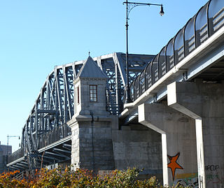
The Third Avenue Bridge is a swing bridge that carries southbound road traffic on Third Avenue over the Harlem River, connecting the boroughs of Manhattan and the Bronx in New York City. It once carried southbound New York State Route 1A. On the Manhattan side, the bridge funnels traffic into three locations: East 128th Street; the intersection of East 129th Street and Lexington Avenue; or FDR Drive in Manhattan.

The Madison Avenue Bridge is a four-lane swing bridge crossing the Harlem River in New York City, carrying East 138th Street between the boroughs of Manhattan and the Bronx. It was designed by Alfred P. Boller and built in 1910, doubling the capacity of an earlier swing bridge built in 1884. The bridge is operated and maintained by the New York City Department of Transportation.
The 145th Street Bridge is a four-lane swing bridge across the Harlem River in New York City, connecting West 145th Street and Lenox Avenue in Manhattan with East 149th Street and River Avenue in the Bronx. The bridge is operated and maintained by the New York City Department of Transportation.

The University Heights Bridge is a steel-truss revolving swing bridge across the Harlem River in New York City. It connects West 207th Street in the Inwood neighborhood of Manhattan with West Fordham Road in the University Heights neighborhood of the Bronx. The bridge is operated and maintained by the New York City Department of Transportation.

The Manhattan Waterfront Greenway is a waterfront greenway for walking or cycling, 32 miles (51 km) long, around the island of Manhattan, in New York City. The largest portions are operated by the New York City Department of Parks and Recreation. It is separated from motor traffic, and many sections also separate pedestrians from cyclists. There are three principal parts — the East, Harlem and Hudson River Greenways.

Transportation in New York City has ranged from strong Dutch authority in the 17th century, expansionism during the industrial era in the 19th century and half of the 20th century, to cronyism during the Robert Moses era. The shape of New York City's transportation system changed as the city did, and the result is an expansive modern-day system of industrial-era infrastructure. New York City, being the most populous city in the United States, has a transportation system which includes one of the largest subway systems in the world; the world's first mechanically ventilated vehicular tunnel; and an aerial tramway.
The 129th Street station was a transfer station on the IRT Third Avenue Line in Manhattan, New York City, shared by elevated trains of both the Third Avenue Line and IRT Second Avenue Line. The next stop to the north was 133rd Street for the main line and Willis Avenue for the Willis Avenue spur, both of which were across a swing bridge above the Harlem River in the Bronx. The next stop to the south was 125th Street−Third Avenue for Third Avenue Line trains and 125th Street−Second Avenue for Second Avenue Line trains.
The Willis Avenue station was an elevated rapid transit station of the Willis Avenue Spur that branched off of the IRT Third Avenue Line in the Bronx, New York City. It opened in 1886 and closed in 1924.
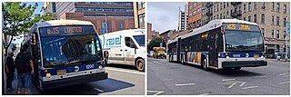
The Bx15 and M125 bus routes constitute the Third Avenue/125th Street Line, a public transit line in New York City. The Bx15 runs between Fordham Plaza and the Hub in the Bronx, running primarily along Third Avenue. The M125 runs between the Hub in the Bronx and Manhattanville in Manhattan, running along Willis Avenue in the South Bronx and along 125th Street in Harlem, Manhattan.


