High Bridge (New York City)

Last updated • 8 min readFrom Wikipedia, The Free Encyclopedia

High Bridge
High Bridge jeh.JPG
View of the closed bridge from Highbridge Park in 2008
Coordinates 40°50′32″N73°55′49″W / 40.842308°N 73.930277°W / 40.842308; -73.930277
CarriesPedestrians and bicycles
Crosses Harlem River
Locale Manhattan and the Bronx,
New York City
Owner Government of New York City
Maintained by NYC Parks
Preceded by Alexander Hamilton Bridge
Followed by Macombs Dam Bridge
Characteristics
Design Arch bridge
Total length1,450 ft (440 m) [1]
Height140 ft (43 m) [1]
History
Opened1848 (aqueduct)
1864 (walkway)
2015 (dedicated walkway)
Rebuilt1927
Closed1949 (water supply)
c.1970–2015
Statistics
High Bridge
NRHP reference No. 72001560
NYSRHP No.06101.006666
NYCL No.0639
Significant dates
Added to NRHPDecember 4, 1972
Designated NYSRHPJune 23, 1980 [2]
Designated NYCLNovember 10, 1970
Location
High Bridge (New York City)

The High Bridge (originally the Aqueduct Bridge) is a steel arch bridge connecting the New York City boroughs of the Bronx and Manhattan. Rising 140 ft (43 m) over the Harlem River, it is the city's oldest bridge, having opened as part of the Croton Aqueduct in 1848. The eastern end is located in the Highbridge section of the Bronx near the western end of West 170th Street, and the western end is located in Highbridge Park in Manhattan, roughly parallel to the end of West 174th Street. [3]

Contents

High Bridge was originally completed in 1848 with 16 individual stone arches. In 1928, the five that spanned the Harlem River were replaced by a single 450-foot (140 m) steel arch. The bridge was closed to all traffic from around 1970 until its restoration, which began in 2009. The bridge was reopened to pedestrians and bicycles on June 9, 2015.

The bridge is operated and maintained by the New York City Department of Parks and Recreation.

History

Background

The High Bridge was part of the first reliable and plentiful water supply system in New York City. As the City was devastated by cholera in 1832 and the Great Fire in 1835, the inadequacy of the water system of wells-and-cisterns became apparent. Numerous corrective measures were examined. [4] In the final analysis, only the Croton River in northern Westchester County was found to carry water sufficient in quantity and quality to serve the City. The delivery system was begun in 1837, and was completed in 1848. [4]

The Old Croton Aqueduct was the first of its kind ever constructed in the United States. The innovative system used a classic gravity feed, dropping 13 inches (330 mm) per mile, or about 1/4" per 100' (~0.02%) [5] and running 41 miles (66 km) into New York City through an enclosed masonry structure crossing ridges, valleys, and rivers. University Avenue was later built over the southernmost mainland portion of the aqueduct, leading to the bridge. Though the carrying capacity was enlarged in 1861–1862 with a larger tube, the bridge became obsolete in 1910 with the opening of the New Croton Aqueduct. [4] In the 1920s, the bridge's masonry arches were declared a hazard to ship navigation by the United States Army Corps of Engineers, and the City considered demolishing the entire structure. Local organizations called to preserve the historic bridge, and, in 1927, five of the original arches across the river were replaced by a single steel span, while the remaining arches were retained. [1]

Construction

Originally designed as a stone arch bridge, the High Bridge had the appearance of a Roman aqueduct. Construction on the bridge was started in 1837, and was completed in 1848 as part of the Croton Aqueduct, which carried water from the Croton River to supply the then burgeoning city of New York some 10 miles (16 km) to the south. The bridge has a height of 140 ft (43 m) above the 620-foot-wide (190 m) Harlem River, with a total length of 1,450 ft (440 m). [1] The design of the bridge was originally awarded to Major David Bates Douglass, who was fired from the project. [6] The design then fell to the aqueduct's engineering team, led by John B. Jervis. James Renwick Jr., who later went on to design the landmark Saint Patrick's Cathedral on Fifth Avenue in Midtown Manhattan, participated in the design.

45 William England - High Bridge, Harlem River, New York.jpg
Photo from William England, 1859
View of the High Bridge, NY 1861.jpg
View of the High Bridge, 1861
High Bridge and high service works & reservoir.jpg
The High Bridge, High Bridge Water Tower, and Highbridge Reservoir in 1871

The Croton Aqueduct had to cross the Harlem River at some point, and the method was a major design decision. A tunnel under the river was considered, but tunneling technology was in its infancy at the time, and the uncertainty of pursuing this option led to its rejection. This left a bridge, with the Water Commission, engineers and the public split between a low bridge and a high bridge. A low bridge would have been simpler, faster, and cheaper to construct. When concerns were raised to the New York Legislature that a low bridge would obstruct passage along the Harlem River to the Hudson River, a high bridge was ultimately chosen.

The contractors for the project were George Law, Samuel Roberts and Arnold Mason. [7] Mason had prior engineering experience working on the Erie Canal and the Morris Canal. [8]

Post-opening

The bridge in 1844, by William James Bennett View of High Bridge and the Harlem River (NYPL Hades-118669-54795) crop.tif
The bridge in 1844, by William James Bennett

In 1864, a pedestrian walkway was built across the High Bridge. The New York City Department of Parks and Recreation which is responsible for its maintenance, described the walkway as the bridge's contemporary High Line. [9]

As part of a U.S. federal government initiative to improve navigation along the Harlem River, in 1923, a New York City Board of Estimate committee recommended demolishing the High Bridge. The bridge's stones would have been reused for a bridge carrying Riverside Drive above Dyckman Street in Inwood, Manhattan. [10] In 1928, the five masonry arches that spanned the river were demolished and replaced with a single steel arch of about 450 feet (140 m). [1] Of the masonry arches of the original 1848 bridge, only one survives on the Manhattan side, while nine survive on the Bronx side.

Use of the structure to deliver water to Manhattan ceased on December 15, 1949.

By 1954, The New York Times reported that the commissioner of the Department of Water Supply, Gas and Electricity said that "the bridge entailed serious problems of maintenance and vandalism". [11] Robert Moses agreed to take responsibility for the bridge, which was transferred to the Parks Department in 1955. [12] There were incidents, in 1957 and 1958, of pedestrians throwing sticks, stones, and bricks from the bridge, seriously injuring passengers on Circle Line tour boats which passed under the bridge. [13] The bridge was closed by 1970, when high crime and fiscal crisis led to the contraction of many city services and public spaces. [4] However, a reporter for The New York Times wrote that when he had tried to walk across the bridge in 1968, it was closed. [14] The New York City Landmarks Preservation Commission (LPC) designated the High Bridge as a city landmark on November 15, 1970. [15] [16]

Bronxians arrive Manhattan on Hibridge jeh.jpg
Reopening day, June 9, 2015. Bronxites arrive for the opening ceremony
Gold plated scissors & Green ribbon HB jeh.jpg
Gold-plated scissors and green ribbon used to reopen the bridge

In November 2006, the Department of Parks and Recreation announced that the bridge would reopen to pedestrians in 2009. [17] This date was repeatedly put off. A $20 million renovation project would include strengthening the arch, improving staircases, cameras on both ends of the bridge, and boat beacon lights among other features. [18]

In 2009, preliminary planning, funded by PlaNYC, began for restoring the High Bridge. [17] The High Bridge Coalition raised funds and public awareness to restore High Bridge to pedestrian and bicycle traffic, joining the Highbridge Parks in both Manhattan and the Bronx that together cover more than 120 acres (0.49 km2) of parkland, and providing a link in New York's greenway system. [19] In early 2010, a contract was signed with Lichtenstein Consulting Engineers and Chu & Gassman Consulting Engineers (MEP sub-consultant) to provide designs for the restored bridge. [20]

On January 11, 2013, the mayor's office announced the bridge would reopen for pedestrian traffic by 2014, [21] but in August 2014, the open was postponed to spring of 2015. [22] In May 2015, the Parks Department announced a July opening [23] and a July 25 festival. [24] The ribbon was cut for the restored bridge at about 11:30 a.m. on June 9, 2015, with the bridge open to the general public at noon. [21] [25] [26] The High Bridge was illuminated at night following its restoration. [27]

High Bridge Water Tower

2014 High Bridge Water Tower from below north.jpg
The tower, seen from the north
2014 High Bridge Water Tower top from below southwest.jpg
The top of the tower, seen from the south
High Bridge Water Tower from High Bridge span.jpg
From mid-span of High Bridge

The High Bridge Water Tower, in Highbridge Park between West 173rd and 174th streets, on top of the ridge on the Manhattan side of High Bridge, was built in 1866–1872 to help meet the ever-increasing demands on the city's water system. The 200-foot (61 m) octagonal tower, which was authorized by the State Legislature in 1863, was designed by John B. Jervis, the engineer who supervised the building of the High Bridge Aqueduct. Water was pumped up 100 feet (30 m) to a 7-acre (2.8 ha) reservoir next to the tower – now the site of a play center and public pool built in 1934–1936 – which then provided water to be lifted to the tower's 47,000 US gallons (180 m3) tank. This "high service" improved the water system's gravity pressure, necessary because of the increased use of flush toilets. [28] [29] [30]

The High Bridge system reached its full capacity by 1875. [30] With the opening of the New Croton Aqueduct in 1890, the High Bridge system became less relied upon; during World War I, it was completely shut down when sabotage was feared. [30] In 1949, the tower was removed from service, [28] [30] and a carillon, donated by the Altman Foundation, was installed in 1958. [30]

The tower's cupola was damaged by an arson fire in 1984. It was reconstructed, and the tower's load-bearing exterior stonework – which Jervis designed in a mixture of Romanesque Revival and neo-Grec styles – was cleaned and restored in 1989–1990 by the William A. Hall Partnership. [29] [30] Christopher Gray has said of the tower's design that "Its rock-faced granite gives the tower a chunky, fortified appearance, as if it were a lookout for a much larger castle complex that was never built.... The granite is competently handled, but the details are not very inspired or elegant. The tower is more picturesque than beautiful." [30]

The interior of the tower, which was never open to the public, features a wide well-detailed iron spiral staircase with six large landings and paired windows. [30]

The High Bridge Water Tower was designated a New York City landmark by the Landmarks Preservation Commission in 1967. [28] The High Bridge Water Tower underwent a 10-year, $5 million renovation during the 2010s and reopened to the public in November 2021. [31] [32] After the water tower reopened, NYC Parks began hosting free tours of the structure. [33]

See also

Related Research Articles

<span class="mw-page-title-main">Washington Heights, Manhattan</span> Neighborhood in New York City

Washington Heights is a neighborhood in the northern part of the borough of Manhattan in New York City. It is named for Fort Washington, a fortification constructed at the highest natural point on Manhattan by Continental Army troops to defend the area from the British forces during the American Revolutionary War. Washington Heights is bordered by Inwood to the north along Dyckman Street, by Harlem to the south along 155th Street, by the Harlem River and Coogan's Bluff to the east, and by the Hudson River to the west.

<span class="mw-page-title-main">Harlem River</span> Tidal strait in New York City

The Harlem River is an 8-mile (13 km) tidal strait in New York City, New York, flowing between the Hudson River and the East River and separating the island of Manhattan from the Bronx on the United States mainland.

<span class="mw-page-title-main">Spuyten Duyvil Creek</span> Tidal estuary connecting the Hudson River to the Harlem River Ship Canal in New York City

Spuyten Duyvil Creek is a short tidal estuary in New York City connecting the Hudson River to the Harlem River Ship Canal and then on to the Harlem River. The confluence of the three water bodies separate the island of Manhattan from the Bronx and the rest of the mainland. Once a distinct, turbulent waterway between the Hudson and Harlem rivers, the creek has been subsumed by the modern ship canal.

<span class="mw-page-title-main">Highbridge, Bronx</span> Neighborhood of the Bronx in New York City

Highbridge is a residential neighborhood geographically located in the central-west section of the Bronx, New York City. Its boundaries, starting from the north and moving clockwise, are the Cross-Bronx Expressway to the north, Jerome Avenue to the east, Macombs Dam Bridge to the south, and the Harlem River to the west. Ogden Avenue is the primary thoroughfare through Highbridge.

<span class="mw-page-title-main">New Croton Dam</span> Dam in New York, USA

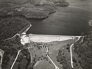
The New Croton Dam is a dam forming the New Croton Reservoir, both parts of the New York City water supply system. It stretches across the Croton River near Croton-on-Hudson, New York, about 22 miles (35 km) north of New York City.

<span class="mw-page-title-main">Croton Aqueduct</span> 19th-century aqueduct serving New York City

The Croton Aqueduct or Old Croton Aqueduct was a large and complex water distribution system constructed for New York City between 1837 and 1842. The great aqueducts, which were among the first in the United States, carried water by gravity 41 miles (66 km) from the Croton River in Westchester County to reservoirs in Manhattan. It was built because local water resources had become polluted and inadequate for the growing population of the city. Although the aqueduct was largely superseded by the New Croton Aqueduct, which was built in 1890, the Old Croton Aqueduct remained in service until 1955.

The Macombs Dam Bridge is a swing bridge across the Harlem River in New York City, connecting the boroughs of Manhattan and the Bronx. The bridge is operated and maintained by the New York City Department of Transportation (NYCDOT).

<span class="mw-page-title-main">Hudson Line (Metro-North)</span> Metro-North Railroad line in New York

The Hudson Line is a commuter rail line owned and operated by the Metro-North Railroad in the U.S. state of New York. It runs north from New York City along the east shore of the Hudson River, terminating at Poughkeepsie. The line was originally the Hudson River Railroad, and eventually became the Hudson Division of the New York Central Railroad. It runs along what was the far southern leg of the Central's famed "Water Level Route" to Chicago.

<span class="mw-page-title-main">Alexander Hamilton Bridge</span> Bridge between Manhattan and the Bronx, New York

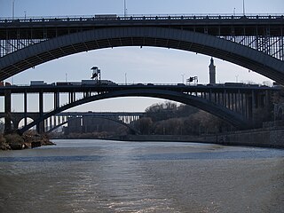
The Alexander Hamilton Bridge is an eight-lane steel arch bridge that carries traffic over the Harlem River between the boroughs of Manhattan and the Bronx in New York City. The bridge connects the Trans-Manhattan Expressway in the Washington Heights section of Manhattan with the Cross Bronx Expressway as part of Interstate 95 and U.S. 1.

<span class="mw-page-title-main">Washington Bridge (Harlem River)</span> Bridge in New York City

The Washington Bridge is a 2,375-foot (724 m)-long arch bridge over the Harlem River in New York City between the boroughs of Manhattan and the Bronx. The crossing, opened in 1888, connects 181st Street and Amsterdam Avenue in Washington Heights, Manhattan, with University Avenue in Morris Heights, Bronx. It carries six lanes of traffic, as well as sidewalks on both sides. Ramps at either end of the bridge connect to the Trans-Manhattan Expressway and the Cross Bronx Expressway, and serves as a connector/highway to the highway itself.

<span class="mw-page-title-main">Van Cortlandt Park</span> Large public park in the Bronx, New York

Van Cortlandt Park is a 1,146-acre (464 ha) park located in the borough of the Bronx in New York City. Owned by the New York City Department of Parks and Recreation, it is managed with assistance from the Van Cortlandt Park Alliance. The park, the city's third-largest, was named for the Van Cortlandt family, which was prominent in the area during the Dutch and English colonial periods.

<span class="mw-page-title-main">New York City water supply system</span> Municipal water supply system

A combination of aqueducts, reservoirs, and tunnels supplies fresh water to New York City. With three major water systems stretching up to 125 miles (201 km) away from the city, its water supply system is one of the most extensive municipal water systems in the world.

<span class="mw-page-title-main">University Heights Bridge</span> Bridge in New York City

The University Heights Bridge is a steel-truss revolving swing bridge across the Harlem River in New York City. It connects West 207th Street in the Inwood neighborhood of Manhattan with West Fordham Road in the University Heights neighborhood of the Bronx. The bridge is operated and maintained by the New York City Department of Transportation.

<span class="mw-page-title-main">Highbridge Park</span> Public park in Manhattan, New York

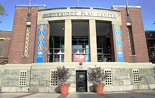
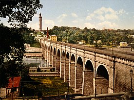
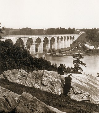
Highbridge Park is a public park on the western bank of the Harlem River in Washington Heights, Manhattan, New York City. It stretches between 155th Street and Dyckman Street in Upper Manhattan. The park is operated by the New York City Department of Parks and Recreation. The City maintains the southern half of the park, while the northern half is maintained by the non-profit New York Restoration Project. Prominent in the park are the Manhattan end of the High Bridge, the High Bridge Water Tower, and the Highbridge Play Center.

<span class="mw-page-title-main">Muscoot Reservoir</span> Reservoir in New York state, USA

The Muscoot Reservoir is a reservoir in the New York City water supply system in northern Westchester County, New York, located directly north of the village of Katonah. Part of the system's Croton Watershed, it is 25 miles north of the City.

<span class="mw-page-title-main">Manhattan Waterfront Greenway</span> Esplanade in Manhattan, New York

The Manhattan Waterfront Greenway is a waterfront greenway for walking or cycling, 32 miles (51 km) long, around the island of Manhattan, in New York City. The largest portions are operated by the New York City Department of Parks and Recreation. It is separated from motor traffic, and many sections also separate pedestrians from cyclists. There are three principal parts — the East, Harlem and Hudson River Greenways.

<span class="mw-page-title-main">Highbridge Reservoir</span>

Highbridge Reservoir was a reservoir in the New York City water supply system, which received water from a portion of the Croton Aqueduct system. It was located on Amsterdam Avenue between 172nd Street and 174th Street, in Upper Manhattan adjacent to the High Bridge Water Tower and the High Bridge across the Harlem River Valley. The reservoir covered about 7 acres (28,000 m2), was 16 feet (4.9 m) deep, and had a total capacity of 10,794,000 US gallons (40,860,000 L).

<span class="mw-page-title-main">Concourse, Bronx</span> Neighborhood of the Bronx in New York City

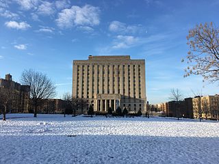
Concourse is a neighborhood in the southwestern section of the New York City borough of the Bronx which includes the Bronx County Courthouse, the Bronx Museum of the Arts, and Yankee Stadium. Its boundaries, starting from the north and moving clockwise, are East 169th Street to the north, Webster Avenue to the east, East 149th Street to the south, and Jerome Avenue and Harlem River to the west. The neighborhood is divided into three subsections: West Concourse, East Concourse, and Concourse Village with the Grand Concourse being its main thoroughfare.

<span class="mw-page-title-main">Aqueduct Walk</span> Community park in the Bronx, New York

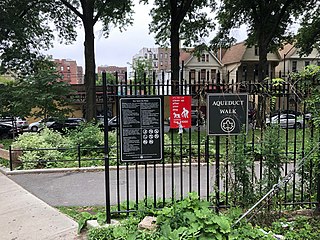
Aqueduct Walk is a community park in The Bronx, New York City, located between Kingsbridge Road and West Tremont Avenue. It spans over two zip codes and two Bronx community boards. Its facilities include basketball courts, restrooms, playground and water sprinklers. The park forms part of the Old Croton Aqueduct and is a New York City scenic landmark.

References

Notes

  1. 1 2 3 4 5 "Croton Water Supply System". ASCE Metropolitan Section. American Society of Civil Engineers. n.d. Archived from the original on October 25, 2016. Retrieved October 25, 2016.
  2. "Cultural Resource Information System (CRIS)". New York State Office of Parks, Recreation and Historic Preservation. November 7, 2014. Retrieved July 20, 2023.
  3. Ramey, Corinne (June 8, 2015). "The Grass Is Greener on the Other Side". Wall Street Journal. ISSN   0099-9660 . Retrieved June 9, 2015.
  4. 1 2 3 4 Dwyer, Jim (June 4, 2015). "A Stunning Link to New York's Past Makes a Long-Awaited Return". The New York Times. ISSN   0362-4331 . Retrieved October 25, 2016.
  5. "An Engineering Marvel". Friends of the Old Croton Aqueduct. Retrieved July 1, 2010.
  6. Eldredge, Niles and Horenstein, Sidney (2014). Concrete Jungle: New York City and Our Last Best Hope for a Sustainable Future. Berkeley, California: University of California Press. p. 141. ISBN   978-0-520-27015-2.
  7. Hough, Franklin Benjamin. Gazetteer of the State of New York: Embracing a Comprehensive Account of the History and Statistics of the State, with Geological and Topographical Descriptions, and Recent Statistical Tables, 1872, page 416
  8. Journal of the Western Society of Engineers, Vols. 43-45, page 4
  9. "History of the High Bridge: NYC Parks". www.nycgovparks.org. Retrieved October 25, 2016.
  10. "High Bridge to Go; Replica to Be Built; Historic Span's Stone Will Be Used and Architecture Followed in New Viaduct". The New York Times. June 19, 1923. Retrieved September 29, 2024.
  11. O'Kane, Lawrence (July 8, 1954). "Span is 'Swapped' on City Boat Ride; Top Officials, Viewing Harlem River Drive From Tug, Get Into Deal for High Bridge". The New York Times. Retrieved September 29, 2024.
  12. "River Landmarks to Be Park Units; Plan Board Transfers Span and Tower at High Bridge From Water Department". The New York Times. January 20, 1955. Retrieved September 29, 2024.
  13. "Boys Stone Boat, Hurt Sight-seers; 4 on Excursion Craft Hit as Youths Hurl Objects From High Bridge in Bronx". The New York Times. April 21, 1958. Retrieved September 29, 2024.
  14. Bird, David (October 27, 1968). "A 32-Mile-Long Swath of Green From the Country to the City". The New York Times. ISSN   0362-4331 . Retrieved September 11, 2017.
  15. "Mansions and Span Ruled Landmarks". The New York Times. November 16, 1970. ISSN   0362-4331 . Retrieved September 30, 2022.
  16. "Landmark Decisions". New York Daily News. November 16, 1970. p. 5. Retrieved September 30, 2022.
  17. 1 2 "High Bridge PlaNYC Project Overview". New York City Department of Parks & Recreation. Retrieved November 11, 2010.
  18. Hughes, C. J. (May 20, 2007). "Living In: High Bridge, the Bronx - Home of the Bronx Roar". The New York Times . Retrieved May 20, 2007.
  19. "The High Bridge & Highbridge Parks" (PDF). High Bridge Coalition. 2005. Archived from the original (PDF) on October 5, 2012. Retrieved July 1, 2010.
  20. Aaron, Brad (February 11, 2010). "High Bridge Restoration Off and Running". Streetsblog New York City. Retrieved July 1, 2010.
  21. 1 2 Artz, Kristen (January 11, 2013). "Mayor Bloomberg Breaks Ground On Project To Restore The High Bridge Over Harlem River And Reopen It To Pedestrians And Bicyclists". NYC, the official website of the City of New York. Retrieved June 27, 2015.
  22. Clarke, Erin (August 28, 2014). "High Bridge's Reopening Slated for Spring". NY1 . Archived from the original on December 5, 2014. Retrieved December 5, 2014.
  23. "The High Bridge Reconstruction Project". New York City Department of Parks and Recreation. Retrieved May 30, 2015.
  24. "High Bridge Events". NYC Parks. Archived from the original on March 4, 2016. Retrieved June 1, 2015.
  25. "High Bridge reopens to bikes, pedestrians" Archived July 28, 2015, at the Wayback Machine MyFox TV
  26. Foderaro, Lisa W. (June 10, 2015). "High Bridge Reopens After More Than 40 Years". The New York Times . p. A19. Retrieved December 29, 2015.
  27. "Light Bridges the Gap: High Bridge Restoration". Horton Lees Brogden Lighting Design. Archived from the original on July 10, 2022. Retrieved July 10, 2022.
  28. 1 2 3 New York City Landmarks Preservation Commission; Dolkart, Andrew S.; Postal, Matthew A. (2009). Postal, Matthew A. (ed.). Guide to New York City Landmarks (4th ed.). New York: John Wiley & Sons. p. 210. ISBN   978-0-470-28963-1.
  29. 1 2 White, Norval; Willensky, Elliot; Leadon, Fran (2010). AIA Guide to New York City (5th ed.). New York: Oxford University Press. p. 566. ISBN   978-0-19538-386-7.
  30. 1 2 3 4 5 6 7 8 Gray, Christopher (October 9, 1988). "Streetscapes: The High Bridge Water Tower; Fire-Damaged Landmark To Get $900,000 Repairs". The New York Times .
  31. "NYC's historic High Bridge Water Tower in Washington Heights reopening soon after more than a decade". ABC7 New York. October 27, 2021. Retrieved November 15, 2022.
  32. Rahmanan, Anna (October 28, 2021). "You can tour this historic NYC tower for the first time in a decade". Time Out New York. Retrieved November 15, 2022.
  33. Sheidlower, Noah (March 7, 2022). "Go Inside NYC's High Bridge Water Tower". Untapped New York. Retrieved November 15, 2022.

Further reading