Highbridge, Bronx

Last updated

Highbridge
Deegan 161 jeh.jpg
Looking north from 161st Street pedestrian overpass at Major Deegan Expressway
Highbridge, Bronx
Location in New York City
Coordinates: 40°50′13″N73°55′44″W / 40.837°N 73.929°W / 40.837; -73.929 Coordinates: 40°50′13″N73°55′44″W / 40.837°N 73.929°W / 40.837; -73.929
Country Flag of the United States.svg  United States
State Flag of New York.svg  New York
City Flag of New York City.svg New York City
Borough Flag of Bronx County, New York.svg The Bronx
Community District The Bronx 4 [1]
Area
[2]
  Total1.57 km2 (0.605 sq mi)
Population
 (2010) [3]
  Total37,727
  Density24,000/km2 (62,000/sq mi)
Economics
   Median income $27,041
ZIP Codes
10452
Area code 718, 347, 929, and 917
Website www.highbridge.nyc

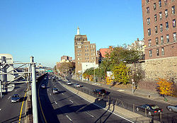
Highbridge is a residential neighborhood geographically located in the central-west section of the Bronx, New York City. Its boundaries, starting from the north and moving clockwise, are the Cross-Bronx Expressway to the north, Jerome Avenue to the east, Macombs Dam Bridge to the south, and the Harlem River to the west. Ogden Avenue is the primary thoroughfare through Highbridge.

Contents

The neighborhood is part of Bronx Community Board 4, and its ZIP Code is 10452. The local subway is the IND Concourse Line ( B and D trains), operating along the Grand Concourse, and the IRT Jerome Avenue Line ( 4 train), operating along Jerome Avenue. The area is patrolled by the New York City Police Department's 44th Precinct. [4] NYCHA property in the area is patrolled by P.S.A. 7 at 737 Melrose Avenue in the Melrose section of the Bronx.

History

At the time of European settlement, the southern Bronx was inhabited by the Siwanoy, a tribe of the Wappinger confederacy. They called the hill that is now Highbridge "Nuasin," or "the land between," for its location between the Harlem River and an estuary that formerly flowed in the area of modern-day Jerome Avenue. [5]

The neighborhood takes its name from the High Bridge, built in 1848 by Irish immigrants. [6] The structure originally carried Croton Aqueduct water across the Harlem River. [7] In 1864, a walkway was built across the High Bridge. [8] Use of the structure to deliver water to Manhattan ceased in 1949. The bridge was closed to pedestrian traffic in the 1970s in the middle of the fiscal crisis affecting the city, and allowed to fall into disrepair; in 2015 a reconstruction project was undertaken and completed with the opening of the bridge in 2019.

In the mid-late 19th century, the area was developed as a suburban retreat for the elite, who built large homes overlooking the Harlem River. The names of these families and their estates are reflected in the names of Highbridge's north-south avenues: Ogden Avenue and Boscobel Place for William B. Ogden, [5] Merriam Avenue for Francis W. Merriam, [5] Anderson Avenue and Woodycrest Avenue for the Anderson family, and Shakespeare Avenue for the Shakespeare Garden on the Marcher family estate. [9] Around the turn of the 20th century, many of these estates were subdivided for urban development, however a few older houses still remain. [5]

In the early 20th century, the neighborhood was served by the Anderson–Jerome Avenues station, which connected the New York City Subway's Ninth Avenue elevated Line with the IRT Jerome Avenue Line ( 4 train).

In the late 1960s, the residents of Highbridge were predominantly of Irish, Italian and Eastern European Jewish descent. They have since been replaced by large numbers of Hispanics and African Americans. [10] As of 2017, the neighborhood is undergoing gentrification. [11]

Demographics

Prior to the 1960s, Highbridge was a predominantly Irish American neighborhood. [10] Today the vast majority of residents in the area are of Dominican, Puerto Rican and African American descent. Almost 40% of families live below the federal poverty line. [12]

Based on data from the 2010 United States Census, the population of Highbridge was 37,727, an increase of 3,883 (11.5%) from the 33,844 counted in 2000. Covering an area of 373.14 acres (151.00 ha), the neighborhood had a population density of 101.1 inhabitants per acre (64,700/sq mi; 25,000/km2). [3]

In 2010, the racial makeup of the neighborhood was 32.9% (12,397) African American, 1.2% (462) White, 0.2% (69) Native American, 0.5% (176) Asian, 0.0% (2) Pacific Islander, 0.3% (103) from other races, and 0.7% (253) from two or more races. Hispanic or Latino of any race were 64.3% (24,265) of the population. [13]

The entirety of Community District 4, which comprises Highbridge and Concourse, had 155,835 inhabitants as of NYC Health's 2018 Community Health Profile, with an average life expectancy of 78.6 years. [14] :2,20 This is lower than the median life expectancy of 81.2 for all New York City neighborhoods. [15] :53 (PDF p. 84) [16] Most inhabitants are youth and middle-aged adults: 27% are between the ages of between 0–17, 29% between 25–44, and 23% between 45–64. The ratio of college-aged and elderly residents was lower, at 11% and 10% respectively. [14] :2

As of 2017, the median household income in Community District 4 was $30,900. [17] In 2018, an estimated 32% of Highbridge and Concourse residents lived in poverty, compared to 25% in all of the Bronx and 20% in all of New York City. One in eight residents (13%) were unemployed, compared to 13% in the Bronx and 9% in New York City. Rent burden, or the percentage of residents who have difficulty paying their rent, is 61% in Highbridge and Concourse, compared to the boroughwide and citywide rates of 58% and 51% respectively. Based on this calculation, as of 2018, Highbridge and Concourse are considered low-income relative to the rest of the city and not gentrifying. [14] :7 However, as of 2017, rents in Highbridge have risen more than any other neighborhood in New York City, at a rate of 22%. [11]

Land use and terrain

A street with steps in Highbridge Hbstairstreet.JPG
A street with steps in Highbridge

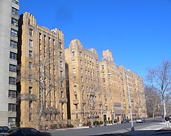
Highbridge is dominated by townhouses and 5 and 6-story apartment buildings, including numerous Art Deco landmarks built by the developer Bernard J. Noonan and the architects Horace Ginsberg and Marvin Fine. [18] Many older detached mansions still remain on Woodycrest Avenue and Ogden Avenue. The total land area is roughly one square mile. The terrain is elevated and very hilly.

Stair streets connect the parts of the neighborhood that are located at different elevations. [19] One particular stair street between Shakespeare and Anderson Avenues became known as the "Joker Stairs", drawing tourists after the 2019 film Joker was filmed there. [20] [21]

Landmarks

Parks

Community gardens

The neighborhood has dozens of community gardens occupying lots that were left vacant between the 1970s and 1990s, including:

Public housing

There are three NYCHA developments located in Highbridge: [33]

Politics

The High Bridge, part of the old Croton Aqueduct High Bridge Deegan jeh.jpg
The High Bridge, part of the old Croton Aqueduct

Highbridge is part of New York's 15th congressional district, the United States' smallest congressional district by area. The district is represented by Democrat Ritchie Torres. [36] [37]

Highbridge is part of New York State Senate District 29, represented by José M. Serrano. Highbridge is divided between two districts of the New York State Assembly. The 77th District is represented by Latoya Joyner, while the 84th District is represented by Carmen E. Arroyo.

Highbridge is part of New York City Council District 8. As of 2017, it is represented by Diana Ayala.

Police and crime

Highbridge and Concourse are patrolled by the 44th Precinct of the NYPD, located at 2 East 169th Street. [4] The 44th Precinct ranked 39th safest out of 69 patrol areas for per-capita crime in 2010. [38] As of 2018, with a non-fatal assault rate of 123 per 100,000 people, Highbridge and Concourse's rate of violent crimes per capita is greater than that of the city as a whole. The incarceration rate of 813 per 100,000 people is higher than that of the city as a whole. [14] :8

The 44th Precinct has a lower crime rate than in the 1990s, with crimes across all categories having decreased by 77.3% between 1990 and 2022. The precinct reported 19 murders, 36 rapes, 713 robberies, 1,048 felony assaults, 421 burglaries, 934 grand larcenies, and 396 grand larcenies auto in 2022. [39]

Fire safety

High Bridge is located near two New York City Fire Department (FDNY) fire stations. [40] Engine Co. 50/Ladder Co. 19/Battalion 26 is located at 1155 Washington Avenue, [41] while Engine Co. 68/Ladder Co. 49 is located at 1160 Ogden Avenue. [42]

In addition, FDNY EMS Station 17 is located at 1080 Ogden Avenue.[ citation needed ]

Health

As of 2018, preterm births and births to teenage mothers are more common in Highbridge and Concourse than in other places citywide. In Highbridge and Concourse, there were 93 preterm births per 1,000 live births (compared to 87 per 1,000 citywide), and 34 births to teenage mothers per 1,000 live births (compared to 19.3 per 1,000 citywide). [14] :11 Highbridge and Concourse has a relatively average population of residents who are uninsured. In 2018, this population of uninsured residents was estimated to be 13%, slightly higher than the citywide rate of 12%. [14] :14

The concentration of fine particulate matter, the deadliest type of air pollutant, in Highbridge and Concourse is 0.0083 milligrams per cubic metre (8.3×10⁻⁹ oz/cu ft), more than the city average. [14] :9 Fifteen percent of Highbridge and Concourse residents are smokers, which is higher than the city average of 14% of residents being smokers. [14] :13 In Highbridge and Concourse, 34% of residents are obese, 17% are diabetic, and 42% have high blood pressure—compared to the citywide averages of 24%, 11%, and 28% respectively. [14] :16 In addition, 23% of children are obese, compared to the citywide average of 20%. [14] :12

Eighty-three percent of residents eat some fruits and vegetables every day, which is less than the city's average of 87%. In 2018, 72% of residents described their health as "good," "very good," or "excellent," lower than the city's average of 78%. [14] :13 For every supermarket in Highbridge and Concourse, there are 18 bodegas. [14] :10

The nearest hospital is Bronx-Lebanon Hospital Center in Claremont. [43]

Post office and ZIP Code

Highbridge is covered by ZIP Code 10452. [44] The United States Postal Service operates the Highbridge Station post office at 1315 Inwood Avenue. [45]

Education

Highbridge and Concourse generally have a lower rate of college-educated residents than the rest of the city as of 2018. While 36% of residents age 25 and older have a college education or higher, 43% have less than a high school education and 21% are high school graduates or have some college education. By contrast, 26% of Bronx residents and 43% of city residents have a college education or higher. [14] :6 The percentage of Highbridge and Concourse students excelling in math rose from 17% in 2000 to 40% in 2011, and reading achievement increased from 21% to 25% during the same time period. [46]

Highbridge and Concourse's rate of elementary school student absenteeism is more than the rest of New York City. In Highbridge and Concourse, 28% of elementary school students missed twenty or more days per school year, higher than the citywide average of 20%. [15] :24 (PDF p. 55) [14] :6 Additionally, 67% of high school students in Highbridge and Concourse graduate on time, lower than the citywide average of 75%. [14] :6

Schools

PS 11, 1257 Ogden Avenue PS91 Highbridge 1257 Ogden jeh.JPG
PS 11, 1257 Ogden Avenue
Sacred Heart School, 1248 Nelson Avenue Sacred Heart School Nelson Av 168 jeh.jpg
Sacred Heart School, 1248 Nelson Avenue

Public schools include:

Parochial schools include:

Libraries

The New York Public Library (NYPL) operates two branches near Highbridge. The Grand Concourse branch is located at 155 East 173rd Street. The branch is a two-story structure that opened in 1959. [49] The High Bridge branch is located at 78 West 168th Street. The branch was opened in the early 20th century and was renovated in 2010. [50]

Transportation

The following New York City Subway stations serve Highbridge: [51]

The following MTA Regional Bus Operations bus routes serve Highbridge: [52]

The Metro-North Railroad's Hudson Line also serves Highbridge at the Yankees–East 153rd Street station.

Notable residents

Related Research Articles

Morrisania is a residential neighborhood in the southwestern Bronx, New York City, New York. Its boundaries are the Cross-Bronx Expressway to the north, Crotona-Prospect Avenue to the east, East 161st Street to the south, and Webster Avenue to the west. Third Avenue is the primary thoroughfare through Morrisania. Its name derives from the Manor of Morrisania, once the entire South Bronx.

<span class="mw-page-title-main">Throggs Neck</span> Neighborhood of the Bronx in New York City

Throggs Neck is a neighborhood and peninsula in the south-eastern portion of the borough of the Bronx in New York City. It is bounded by the East River and Long Island Sound to the south and east, Westchester Creek on the west, and Baisley Avenue and the Bruckner Expressway on the north.

Pelham Gardens is a neighborhood located in the Northeast section of the Bronx, New York City. Its boundaries, starting from the north and moving clockwise are East Gun Hill Road to the north and east, Pelham Parkway to the south, and the IRT Dyre Avenue Line to the west ending at the esplanade. Eastchester Road is the primary thoroughfare through Pelham Gardens.

Allerton is a working-class neighborhood geographically located in the East Bronx section of the Bronx, New York City. It is named in honor of Daniel Allerton, an early Bronx settler who purchased and farmed this area with his wife Hustace. It consists of two subsections called Bronxwood and Laconia. Its boundaries, starting from the north and moving clockwise, are Adee Avenue, Boston Road, and Gun Hill Road to the northeast; the IRT Dyre Avenue Line to the east; Waring Avenue to the south; and Bronx River Parkway to the west. White Plains Road and Boston Road are the primary thoroughfares through Allerton.

<span class="mw-page-title-main">Fordham, Bronx</span> Neighborhood of the Bronx in New York City

Fordham Manor is a neighborhood located in the western Bronx, New York City. Fordham is roughly bordered by East 196th Street to the north, the Harlem River to the west, Fordham Road to the south, and Southern Boulevard to the east. The neighborhood's primary thoroughfares are Fordham Road and Grand Concourse.

<span class="mw-page-title-main">Kingsbridge, Bronx</span> Neighborhood of the Bronx in New York City

Kingsbridge is a residential neighborhood in the northwest portion of the Bronx, New York City. Kingsbridge's boundaries are Manhattan College Parkway to the north, the Major Deegan Expressway or Bailey Avenue to the east, West 230th Street to the south, and Irwin Avenue to the west.

<span class="mw-page-title-main">Tremont, Bronx</span> Neighborhood of the Bronx in New York City

Tremont is a residential neighborhood in the West Bronx, New York City. Its boundaries are East 181st Street to the north, Third Avenue to the east, the Cross-Bronx Expressway to the south, and the Grand Concourse to the west. East Tremont Avenue is the primary thoroughfare through Tremont.

<span class="mw-page-title-main">Melrose, Bronx</span> Neighborhood of the Bronx in New York City

Melrose is a mostly residential neighborhood in the southwestern section of the New York City borough of the Bronx. It adjoins the business and one-time theater area known as The Hub. Melrose is rectangular-shaped, being bordered by Third Avenue on the east, 149th Street on the south, Park Avenue on the west and 161st Street to the north. Melrose Avenue and Third Avenue are the primary thoroughfares through Melrose.

<span class="mw-page-title-main">Mott Haven, Bronx</span> Neighborhood of the Bronx in New York City

Mott Haven is an American primarily residential neighborhood in the southwestern section of the New York City borough of the Bronx. Its boundaries, starting from the north and moving clockwise, are East 149th Street to the north, the Bruckner Expressway to the east, the Major Deegan Expressway to the south, and the Harlem River to the west. East 138th Street is the primary east–west thoroughfare through Mott Haven.

<span class="mw-page-title-main">Williamsbridge, Bronx</span> Neighborhood of the Bronx in New York City

Williamsbridge is a neighborhood geographically located in the north-central portion of the Bronx in New York City. Its boundaries, starting from the north and moving clockwise are East 222nd Street to the north, Boston Road to the east, East Gun Hill Road to the south, and the Bronx River to the west. White Plains Road is the primary thoroughfare through Williamsbridge.

<span class="mw-page-title-main">Country Club, Bronx</span> Neighborhood of the Bronx in New York City

Country Club is a residential neighborhood located in the East Bronx in New York City. The neighborhood's boundaries are Middletown Road and Watt Avenue to the north, Eastchester Bay to the east, Layton Avenue and the Throggs Neck neighborhood to the south, and the New England Thruway and Pelham Bay neighborhood to the west. Pelham Bay Park, the largest public park in New York City, is located just north of Country Club.

<span class="mw-page-title-main">Bedford Park, Bronx</span> Neighborhood of the Bronx in New York City

Bedford Park is a residential neighborhood in the northwest Bronx, New York City, between the New York Botanical Garden and. Its boundaries, starting from the north and moving clockwise are: Mosholu Parkway to the north, Webster Avenue to the east, East 19ht Street to the south, and Jerome Avenue to the west.

<span class="mw-page-title-main">East Tremont, Bronx</span> Neighborhood of the Bronx in New York City

East Tremont is a residential neighborhood located in the West Bronx, New York City. From the north and moving clockwise, it is bounded by East 180th Street, Southern Boulevard, the Cross-Bronx Expressway and Third Avenue. East Tremont Avenue is the primary thoroughfare through the neighborhood.

<span class="mw-page-title-main">Eastchester, Bronx</span> Neighborhood of the Bronx in New York City

Eastchester is a working-class neighborhood in the northeast Bronx in New York City. Its boundaries, starting from the north and moving clockwise are the Bronx-Westchester County border to the north, the New England Thruway to the east, Baychester Avenue to the south, and the intersection of 233rd Street and Baychester Avenue to the west. Boston Road is the primary thoroughfare through Eastchester and Dyre Avenue is the main commercial street. Eastchester includes the sub-neighborhood of Edenwald.

<span class="mw-page-title-main">University Heights, Bronx</span> Neighborhood of the Bronx in New York City

University Heights is a neighborhood of the West Bronx in New York City. Its boundaries, starting from the north and moving clockwise, are: West Fordham Road to the north, Jerome Avenue to the east, West Burnside Avenue to the south and the Harlem River to the west. University Avenue is the primary thoroughfare in University Heights.

<span class="mw-page-title-main">Crotona Park East, Bronx</span> Neighborhood of the Bronx in New York City

Crotona Park East, also known as Crotona or East Morrisania, is a residential neighborhood geographically located in the southwest Bronx in New York City. Crotona Park East is considered part of the South Bronx. Its boundaries, starting from the north and moving clockwise are the Cross-Bronx Expressway to the north, the Bronx River to the east, East 167th Street to the south, and Crotona/Prospect Avenues to the west. Southern Boulevard is the primary thoroughfare through the area. The neighborhood is adjacent to, but distinct from, the nearby park named Crotona Park.

<span class="mw-page-title-main">Morris Heights, Bronx</span> Neighborhood of the Bronx in New York City

Morris Heights is a residential neighborhood located in the West Bronx. Its boundaries, starting from the north and moving clockwise are: West Burnside Avenue to the north, Jerome Avenue to the east, the Cross-Bronx Expressway to the south, and the Harlem River to the west. University Avenue is the primary thoroughfare through Morris Heights.

<span class="mw-page-title-main">Pelham Parkway (neighborhood), Bronx</span> Neighborhood of the Bronx in New York City

Pelham Parkway is a working- and middle-class residential neighborhood geographically located in the center of the Bronx, a borough of New York City in the United States. Its boundaries, starting from the north and moving clockwise are: Waring Avenue to the north, the IRT Dyre Avenue Line tracks to the east, Neill Avenue to the South, and Bronx River Parkway to the west. White Plains Road is the primary commercial thoroughfare through Pelham Parkway. The neighborhood is named after Pelham Parkway, a major west–east parkway that travels through the East Bronx.

<span class="mw-page-title-main">West Farms, Bronx</span> Neighborhood of the Bronx in New York City

West Farms is a residential neighborhood in The Bronx, New York City. Its boundaries, are: Bronx Park to the north, the Bronx River Parkway to the east, the Cross-Bronx Expressway to the south, and Southern Boulevard to the west. East Tremont Avenue is the primary thoroughfare through West Farms.

<span class="mw-page-title-main">Concourse, Bronx</span> Neighborhood of the Bronx in New York City

Concourse is a neighborhood in the southwestern section of the New York City borough of the Bronx which includes the Bronx County Courthouse, the Bronx Museum of the Arts, and Yankee Stadium. Its boundaries, starting from the north and moving clockwise, are East 169th Street to the north, Webster Avenue to the east, the Metro-North Railroad's Hudson Line to the south, and Jerome Avenue to the west. The neighborhood is divided into three subsections: West Concourse, East Concourse, and Concourse Village with the Grand Concourse being its main thoroughfare.

References

  1. "NYC Planning | Community Profiles". communityprofiles.planning.nyc.gov. New York City Department of City Planning. Retrieved February 25, 2018.
  2. "Highbridge neighborhood in New York" . Retrieved August 21, 2015.
  3. 1 2 Table PL-P5 NTA: Total Population and Persons Per Acre - New York City Neighborhood Tabulation Areas*, 2010, Population Division - New York City Department of City Planning, February 2012. Accessed June 16, 2016.
  4. 1 2 "NYPD – 44th Precinct". www.nyc.gov. New York City Police Department . Retrieved October 3, 2016.
  5. 1 2 3 4 5 Merriam Playground, New York City Department of Parks and Recreation. Accessed June 12, 2017.
  6. Winant, Edward (1996). The Hydraulics Revolution: Science and Technical Design of Urban Water Supply during the Enlightenment. West Virginia University.
  7. Eldredge, Niles and Horenstein, Sidney (2014). Concrete Jungle: New York City and Our Last Best Hope for a Sustainable Future. Berkeley, California: University of California Press. p. 141. ISBN   978-0-520-27015-2.
  8. "History of the High Bridge: NYC Parks". www.nycgovparks.org. Retrieved October 25, 2016.
  9. "Highbridge Heights, Bronx". March 28, 2010. Retrieved July 9, 2018.
  10. 1 2 "Bronx Irish Americans: American Irish History in the Bronx" . Retrieved December 5, 2015.
  11. 1 2 "Gentrifying Highbridge Faces a Rocky Future". May 3, 2018. Retrieved June 19, 2018.
  12. "NYC Population FactFinder". popfactfinder.planning.nyc.gov. Retrieved June 19, 2018.
  13. Table PL-P3A NTA: Total Population by Mutually Exclusive Race and Hispanic Origin - New York City Neighborhood Tabulation Areas*, 2010, Population Division - New York City Department of City Planning, March 29, 2011. Accessed June 14, 2016.
  14. 1 2 3 4 5 6 7 8 9 10 11 12 13 14 15 "Highbridge and Concourse (Including Concourse, Concourse Village, East Concourse, Highbridge, Mount Eden and West Concourse)" (PDF). nyc.gov. NYC Health. 2018. Retrieved March 2, 2019.
  15. 1 2 "2016-2018 Community Health Assessment and Community Health Improvement Plan: Take Care New York 2020" (PDF). nyc.gov . New York City Department of Health and Mental Hygiene. 2016. Retrieved September 8, 2017.
  16. "New Yorkers are living longer, happier and healthier lives". New York Post. June 4, 2017. Retrieved March 1, 2019.
  17. "NYC-Bronx Community District 4--Concourse, Highbridge & Mount Eden PUMA, NY" . Retrieved July 17, 2018.
  18. 1 2 , New York City Landmarks Preservation Commission. Accessed March 8, 2018.
  19. Walsh, Kevin (June 6, 1999). "STEP STREETS". Forgotten New York. Retrieved October 23, 2019.
  20. Asmelash, Leah (October 19, 2019). "The 'Joker' stairs might be New York's latest tourist attraction". CNN. Retrieved October 23, 2019.
  21. "'Joker' Fans Come For The Stairs, Locals Hope They Stick Around For Bronx Extras". CBS New York – Breaking News, Sports, Weather, Traffic And The Best of NY. October 21, 2019. Retrieved October 23, 2019.
  22. 1 2 3 Gray, Christoper (January 8, 1989). "STREETSCAPES: Woodycrest Children's Home; A New Life - and Mission - for a Bronx Residence". New York Times . Retrieved June 21, 2017.
  23. , Bronx-Lebanon Hospital Center. Accessed June 21, 2017.
  24. , New York City Landmarks Preservation Commission. Accessed March 8, 2018.
  25. Archived December 9, 2010, at the Wayback Machine , New York City Landmarks Preservation Commission. Accessed March 8, 2018.
  26. "Questions & Answers regarding EBSCO Publishing's Merger with The H.W. Wilson Company" . Retrieved January 6, 2011.
  27. Highbridge Park, New York City Department of Parks and Recreation. Accessed June 12, 2017.
  28. Macombs Dam Park, New York City Department of Parks and Recreation. Accessed June 12, 2017.
  29. Mullaly Park, New York City Department of Parks and Recreation. Accessed June 12, 2017.
  30. Nelson Playground, New York City Department of Parks and Recreation. Accessed July 9, 2018.
  31. Corporal Fischer Park, New York City Department of Parks and Recreation. Accessed July 9, 2018.
  32. Target Bronx Community Garden, New York Restoration Project. Accessed June 12, 2017.
  33. Bronx Development Maps, New York City Housing Authority. Accessed April 3, 2017.
  34. Highbridge Gardens, New York City Housing Authority. Accessed April 3, 2017.
  35. Highbridge Rehabs (Nelson Avenue), New York City Housing Authority. Accessed April 3, 2017.
  36. "New York congressional districts by urban and rural population and land area". United States Census Bureau. Retrieved December 11, 2014.
  37. http://cookpolitical.com/house/pvi#The Median & Most Partisan Districts, 1998-2014
  38. "Highbridge, Concourse Village, Mount Eden – DNAinfo.com Crime and Safety Report". www.dnainfo.com. Archived from the original on April 15, 2017. Retrieved October 6, 2016.
  39. "44th Precinct CompStat Report" (PDF). www.nyc.gov. New York City Police Department . Retrieved July 22, 2018.
  40. "FDNY Firehouse Listing – Location of Firehouses and companies". NYC Open Data; Socrata . New York City Fire Department. September 10, 2018. Retrieved March 14, 2019.
  41. "Engine Company 50/Ladder Company 19/Battalion 26". FDNYtrucks.com. Retrieved March 14, 2019.
  42. "Engine Company 68/Ladder Company 49". FDNYtrucks.com. Retrieved March 14, 2019.
  43. "Best 30 Hospitals in Bronx, NY with Reviews". Yellow Pages. Retrieved March 14, 2019.
  44. "High Bridge, New York City-Bronx, New York Zip Code Boundary Map (NY)". United States Zip Code Boundary Map (USA). Retrieved March 15, 2019.
  45. "Location Details: Highbridge". USPS.com. Retrieved March 7, 2019.
  46. "Highbridge and Concourse – BX 04" (PDF). Furman Center for Real Estate and Urban Policy. 2011. Retrieved October 5, 2016.
  47. Darville, Sarah (October 9, 2014). "Fariña launches abbreviated version of her collaboration initiative". Chalkbeat New York .
  48. Sacred Heart School
  49. "About the Grand Concourse Library". The New York Public Library. Retrieved March 14, 2019.
  50. "About the High Bridge Library". The New York Public Library. Retrieved March 14, 2019.
  51. "Subway Map" (PDF). Metropolitan Transportation Authority. September 2021. Retrieved September 17, 2021.
  52. "Bronx Bus Map" (PDF). Metropolitan Transportation Authority. October 2018. Retrieved December 1, 2020.
  53. "A Boogie wit da Hoodie: "Drowning"". Genius. Genius.com. Retrieved August 15, 2022.
  54. Hamlett-Concepcion, Brittany. "Celebrities who hail from the 'Boogie Down' Bronx", AM New York , November 9, 2015. Accessed June 12, 2017. "Joy Bryant - The Get Rich or Die Tryin star grew up in the High Bridge section of the Bronx."
  55. Kameir, Rawiya. "Cardi B Did It Her Way; Cardi B engineered Instagram fame into reality TV stardom into a poppin’ rap career. Now she’s learning to juggle everything that comes with it.", The Fader , June / July 2017. Accessed August 9, 2017. "Nefi, who is just one of 36 cousins, grew up 'door-by-door' in the same building off 167th Street, in a corner of the Bronx called Highbridge."
  56. Itzkoff, Dave. "For Tracy Morgan, Every Day Is a Show", The New York Times , October 28, 2008. Accessed June 12, 2017. "He was the second of five children, raised in housing projects in Bedford-Stuyvesant, Brooklyn, and the High Bridge section of the Bronx."
  57. "William B. Ogden.", Illinois During the Gilded Age. Accessed June 12, 2017. "His business causing him, of late years, to spend much of his time in New York, he purchased a handsome villa, in the spring of 1866, in Westchester County, at Fordham Heights, adjoining the High Bridge."
  58. "Carl Hancock Rux with Lara Stapleton". May 2004.