Fordham, Bronx

Last updated
Fordham Manor
Monroe Coll Walton Fordham jeh.jpg
Looking south across Fordham Road and along Walton Avenue at Monroe College
Fordham, Bronx
Location in New York City
Coordinates: 40°51′32″N73°53′53″W / 40.859°N 73.898°W / 40.859; -73.898
Country Flag of the United States.svg  United States
State Flag of New York.svg  New York
City Flag of New York City.svg New York City
Borough Flag of Bronx County, New York.svg The Bronx
Community District The Bronx 5 [1] and The Bronx 7 [2]
Area
[3]
  Total0.507 sq mi (1.31 km2)
Population
 (2011) [3]
  Total43,394
  Density86,000/sq mi (33,000/km2)
Economics
   Median income $26,143
ZIP Codes
10453, 10457, 10458, 10468
Area code 718, 347, 929, and 917
Website fordham.nyc

Fordham Manor is a neighborhood located in the western Bronx, New York City. Fordham is roughly bordered by East 196th Street to the north, the Harlem River to the west, Fordham Road to the south, and Southern Boulevard to the east. [4] The neighborhood's primary thoroughfares are Fordham Road and Grand Concourse.

Contents

Fordham Manor is located within Bronx Community Board 5 and Bronx Community Board 7, and its ZIP Codes include 10453, 10457, 10458 and 10468. [1] [2] Its main subway line is the IND Concourse Line ( B and D trains), operating under the Grand Concourse, with the IRT Jerome Avenue Line ( 4 train) on its western border. The area is patrolled by the New York City Police Department's 46th Precinct. New York City Housing Authority (NYCHA) property in the area is patrolled by P.S.A. 7 at 737 Melrose Avenue in the Melrose section of the Bronx. The neighborhood is home to the original, Rose Hill campus of Fordham University.

History

Jan Arcer, a Dutch settler (who anglicized his name to John Archer), [5] established a community at what is now 225th Street near the Harlem River in 1666. [6] Archer owned 3900 acres of land which Francis Lovelace, the colonial governor of New York approved for settlement. [5] The area known as "Fordham Manor" was 6 square miles. This was called a Patent, making Archer "Lord of the Manor". Sixteen families established farms in the area. The Manor lasted from 1671 to 1762.

Archer chose the name Fordham for his community, which may have been a reference to its location near a shallow crossing ("ford") of the Bronx River, or may have been a reference to John Fordham, a fourteenth-century English priest. [7]

Old Fordham Village

Old Fordham Village is a section of Fordham that dates back to the English colonial era. It is centered on the intersection of the Grand Concourse and Fordham Road. Fordham Village extends north to about 196th Street, south to about 187th Street, east to Southern Boulevard, and west to Jerome Avenue.

The section's origins date back to about 1751, when Fordham Manor was built, on what was called Rose Hill. Most of the estate is part of the Rose Hill Campus of Fordham University. Besides the main manor house and other side buildings on the campus, other historic buildings and noted homes still exist within Old Fordham Village. For example, American poet Edgar Allan Poe spent his final years with his wife Virginia in a cottage in Fordham which is still standing in Poe Park. The nearby Fordham University Church bell is named "old Edgar" and may have been the inspiration for his poem The Bells. [8]

In the 18th century, the Kings Road went through Old Fordham Village, an area of rural estates and small farms, linking Colonial New York and towns and villages north toward Boston. It was a minor rest stop for travelers and coaches, where many springs fed The Mill Brook that crossed this road. During the American Revolution, it was a critical crossing point for Gen. George Washington's Continental Army retreating toward White Plains to safely escape from New York while being chased by the Colonial British and Hessian Forces. There were many American Patriots that lived in this area. After the revolution, the Kings Road was renamed the Boston Post Road, becoming an important thoroughfare for a growing new nation.

In the 19th century, with the building of the White Plains Line (later the Harlem Line of the New York Central Railroad) and a small station, Old Fordham Village began to grow. Local farmers and dairymen were now able to use the railroad to send their products to a growing New York City. North of the village, part of the Mill Brook was dammed up, and a large pond and ice house was built for shipping and cold storage. It provided fresh ice for the community and the railroad. In 1838 a wealthy New York City Irish Catholic real estate magnate named Andrew Carrigan (1804-1872) bought the 100-acre Rose Hill estate, located east of the village, for the sole purpose of selling it to his close friend John Joseph Hughes (1797-1864), who at the time was coadjutor bishop of the Diocese of New York. Hughes purchased the estate from Carrigan in 1839 for $29,750, and founded St. Joseph's Seminary (1840) and St. Joseph's College (1841) (later Fordham University) on the property. In 1846 Hughes deeded St. Joseph's College over to the Roman Catholic Jesuit Order (Society of Jesus) for $40,000, but retained title to the seminary property (about 9 acres of land). The seminary was closed in 1859. A small south-west portion of the former Rose Hill estate is known today as Rose Hill Park. [9] West of the village, on the other side of Fordham Hill, the Bathgate Estate was built; it was later acquired by wealthy stock speculator Leonard Jerome. He built the Jerome Park Racetrack, where the first Belmont Stakes was held, on his estate. West of the station in the village area, the Fordham Hotel and Taverine would provide basic needs for visitors to the college and the racetrack. [10] [11]

After 1900

One Fordham Plaza Barnabas Hospital Pyramid Fordham jeh.jpg
One Fordham Plaza

For the most part, Old Fordham Village remained rural until about 1900, when New York City began to expand. Early mass transit to the suburbs changed the area of what is Fordham today. Old Fordham Village and the surrounding area would become part of the borough of the Bronx within New York City. Many of the remaining farms and estates were sold to developers who built houses and sizable apartment buildings. The formerly quiet little village became a major business and transportation hub. In this area of Fordham, Boston Post Road was renamed Fordham Road and became part of U.S. Route 1 in 1926. The rebuilding of the railroad right of way at Fordham, and most of Webster Avenue, eliminated The Mill Brook and water pond, but the side streets of Old Fordham Village remain active. [12]

Fordham was a predominantly middle class White (of Irish and Jewish origins) neighborhood, from the 1920s through the late 1970s, when many families moved to the suburbs or the Los Angeles area, or retired to Florida. [13] [14] Belmont was formerly a portion of Fordham and South Fordham.

On January 9, 2022, a high-rise fire tore through an apartment building in Fordham. At least 19 people were killed, including nine children, and at least 60 other people were injured, including 32 with life-threatening injuries. [15] [16] [17] [18] [19] It was the third-deadliest residential fire in the U.S. since 1978. [20]

Demographics

Fordham near New York Botanical Garden and the Bronx Zoo Fordham near NYBG and Bronx Zoo.jpg
Fordham near New York Botanical Garden and the Bronx Zoo

Fordham has a population of around 43,394 people. Its first growth was in the 1920s, when middle-class and working-class families from Manhattan flocked into the area, attracted by the then-modern housing and convenient subway access by Concourse, Jerome Avenue, and Third/Webster Avenues lines to business districts in Manhattan where they could work and shop. It is now predominantly Latino American and African American. There is a significant historic Italian and Albanian population as well.

Fordham is divided into two sections: Community District 5 south of Fordham Road, comprising Fordham South, and Community District 7 north of Fordham Road, comprising Fordham North. Most inhabitants of Community District 5 are youth and middle-aged adults: 28% are between the ages of between 0–17, 29% between 25 and 44, and 23% between 45 and 64. The ratio of college-aged and elderly residents was lower, at 12% and 8% respectively. [21] :2 Similarly, most inhabitants of Community District 7 are youth and middle-aged adults: 26% are between the ages of between 0–17, 31% between 25 and 44, and 23% between 45 and 64. The ratio of college-aged and elderly residents was lower, at 11% and 9% respectively. [22] :2

As of 2017, the median household income in Community District 5 was $30,166, [23] and the median household income in Community District 7 was $35,355. [24] In 2018, an estimated 34% of Fordham South residents lived in poverty, compared to 25% in all of the Bronx and 20% in all of New York City. One in eight residents (13%) were unemployed, compared to 13% in the Bronx and 9% in New York City. Rent burden, or the percentage of residents who have difficulty paying their rent, is 65% in Fordham South, compared to the boroughwide and citywide rates of 58% and 51% respectively. [21] :7 In 2018, an estimated 26% of Fordham North residents lived in poverty, compared to 25% in all of the Bronx and 20% in all of New York City. One in seven residents (14%) were unemployed, compared to 13% in the Bronx and 9% in New York City. Rent burden, or the percentage of residents who have difficulty paying their rent, is 61% in Fordham North, compared to the boroughwide and citywide rates of 58% and 51% respectively. [22] :7 Based on this calculation, as of 2018, both areas are considered low-income relative to the rest of the city and not gentrifying. [21] :7 [22] :7

Land use and terrain

Fordham is dominated by 5- and 6-story apartment buildings, often set flush to the sidewalk. Many of the apartments on the Grand Concourse are taller.

The New York Botanical Garden and the Wildlife Conservation Society's Bronx Zoo, both inside Bronx Park, collectively occupy dozens of acres of land within the neighborhood.

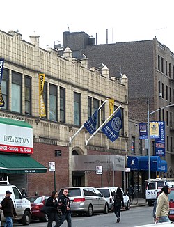
Fordham University maintains its historic original campus on much of the former Rose Hill Manor in the center of the neighborhood. It is one of the largest "green" campuses in New York City, and its traditional collegiate gothic architecture often serves as a backdrop for television and film productions.

The Fordham Road Business Improvement District operates on the northern border of the neighborhood. This retail district is the longest in the Bronx. [25] Fordham is split into two community districts: Community District 5 south of Fordham Road and Community District 7 north of Fordham Road. The entirety of Community District 5, which comprises southern Fordham South, had 136,151 inhabitants as of NYC Health's 2018 Community Health Profile, with an average life expectancy of 79.9 years. [21] :2,20 Community District 7, which comprises Fordham South and Bedford Park, had 148,163 inhabitants as of NYC Health's 2018 Community Health Profile, with an average life expectancy of 79.4 years. [22] :2,20 Both figures are lower than the median life expectancy of 81.2 for all New York City neighborhoods. [26] :53 (PDF p. 84) [27]

Police and crime

46th Police Precinct Bx 46 Pct jeh.JPG
46th Police Precinct

Fordham is patrolled by two precincts of the NYPD. [28] Fordham South is served by the 46th Precinct of the NYPD, located at 2120 Ryer Avenue. [29] Fordham North is patrolled by the 52nd Precinct of the NYPD, located at 3016 Webster Avenue. [30]

The 46th Precinct ranked 27th safest out of 69 patrol areas for per-capita crime in 2010, [31] while the 52nd Precinct ranked 49th safest. [32] As of 2018, with a non-fatal assault rate of 126 per 100,000 people in Fordham South and 97 per 100,000 people in Fordham North, Fordham's rate of violent crimes per capita is greater than that of the city as a whole. The incarceration rates of 1,033 per 100,000 people in Fordham South and 583 per 100,000 people in Fordham Road are both higher than that of the city as a whole. [21] :8 [22] :8

The 46th Precinct has a lower crime rate than in the 1990s, with crimes across all categories having decreased by 74.6% between 1990 and 2022. The precinct reported 17 murders, 34 rapes, 384 robberies, 729 felony assaults, 218 burglaries, 611 grand larcenies, and 219 grand larcenies auto in 2022. [33] The 52nd Precinct also has a lower crime rate than in the 1990s, with crimes across all categories having decreased by 76.1% between 1990 and 2022. The precinct reported 14 murders, 37 rapes, 410 robberies, 598 felony assaults, 192 burglaries, 666 grand larcenies, and 254 grand larcenies auto in 2022. [34]

Fire safety

Fordham contains two New York City Fire Department (FDNY) fire stations. [35] Engine Co. 48/Ladder Co. 56/Division 7 is located at 2417 Webster Avenue, [36] while Engine Co. 75/Ladder Co. 33/Battalion 19 is located at 2175 Walton Avenue. [37]

Health

As of 2018, preterm births in Fordham South and births to teenage mothers in both Fordham South and North are more common than in other places citywide, though preterm births in Fordham North are less common. In Fordham South, there were 93 preterm births per 1,000 live births (compared to 87 per 1,000 citywide), and 35.3 births to teenage mothers per 1,000 live births (compared to 19.3 per 1,000 citywide). [21] :11 In Fordham North, there were 85 preterm births per 1,000 live births (compared to 87 per 1,000 citywide), and 30.3 births to teenage mothers per 1,000 live births (compared to 19.3 per 1,000 citywide). [22] :11 Both areas have a relatively high population of residents who are uninsured. In 2018, this population of uninsured residents was estimated to be 14% in Fordham South and 16% in Fordham North, higher than the citywide rate of 12%. [21] :14 [22] :14

The concentration of fine particulate matter, the deadliest type of air pollutant, is 0.0083 milligrams per cubic metre (8.3×10⁻⁹ oz/cu ft) in Fordham South and 0.0078 milligrams per cubic metre (7.8×10⁻⁹ oz/cu ft) in Fordham North, more than the city average. [21] :9 [22] :9 Sixteen percent of Fordham South residents and twelve percent of Fordham North residents are smokers, which is higher than the city average of 14% of residents being smokers. [21] :13 [22] :13 In Fordham South, 34% of residents are obese, 16% are diabetic, and 27% have high blood pressure—compared to the citywide averages of 24%, 11%, and 28% respectively. [21] :16 In Fordham North, 33% of residents are obese, 19% are diabetic, and 35% have high blood pressure. [22] :16 In addition, 24% of children in Fordham South and 25% of children in Fordham North are obese, compared to the citywide average of 20%. [21] :12 [22] :12

Seventy-eight percent of residents in Fordham South and eighty-four percent in Fordham North eat some fruits and vegetables every day, which is less than the city's average of 87%. In 2018, 67% of residents in both Fordham South and North described their health as "good", "very good", or "excellent", lower than the city's average of 78%. [21] :13 [22] :13 For every supermarket, there are 20 bodegas in Fordham South and 18 in Fordham North. [21] :10 [22] :10

The nearest hospitals are Bronx-Lebanon Hospital Center in Claremont, James J. Peters VA Medical Center in Kingsbridge Heights, and St Barnabas Hospital in Belmont. [38]

Post office and ZIP Codes

Fordham is divided into four ZIP Codes by the north-south Grand Concourse and the west-east East 183rd Street. Counterclockwise from southwest, these zip codes are 10453, 10457, 10458 and 10468. [39] The United States Postal Service operates the Jerome Station post office at 2549 Jerome Avenue. [40]

Education

Fordham generally has a lower rate of college-educated residents than the rest of the city as of 2018. In Fordham South, 10% of residents age 25 and older have a college education or higher, while 34% have less than a high school education and 46% are high school graduates or have some college education. In Fordham North, 23% of residents age 25 and older have a college education or higher, while 32% have less than a high school education and 45% are high school graduates or have some college education. By contrast, 26% of Bronx residents and 43% of city residents have a college education or higher. [21] :6 [22] :6 The percentage of Fordham South students excelling in math rose from 19% in 2000 to 43% in 2011, and reading achievement increased from 24% to 28% during the same time period. [41] The percentage of Fordham North students excelling in math also rose from 21% in 2000 to 48% in 2011, and reading achievement increased from 28% to 33% during the same time period. [42]

Fordham South and Fordham North's rates of elementary school student absenteeism are higher than the rest of New York City. 30% of elementary school students in Fordham South and 28% in Fordham North missed twenty or more days per school year, higher than the citywide average of 20%. [26] :24 (PDF p. 55) [21] :6 [22] :6 Additionally, 66% of high school students in Fordham South and 70% of high school students in Fordham North graduate on time, lower than the citywide average of 75%. [21] :6 [22] :6

Schools

Fordham contains the following public elementary schools: [43]

The following public middle schools serve grades 6–8 unless otherwise indicated: [43]

The Rose Hill campus of Fordham University, which is the university's oldest campus, is located in Fordham. The campus is home to Fordham College at Rose Hill, the Gabelli School of Business, and a division of the School of Professional and Continuing Studies, as well as the Graduate Schools of Arts and Sciences and Religion and Religious Education. [50]

Monroe College, a private for-profit college, has been located in Fordham since 1967, and is near the Fordham shopping district. [51]

Library

The New York Public Library (NYPL) operates the Bronx Library Center at 310 East Kingsbridge Road. The Bronx Library Center opened in 2006 and is the Bronx's largest NYPL branch. [52]

Transportation

The Bx12 Select Bus Service stops in front of Fordham Plaza above Fordham's Metro-North railroad station. Bx12 5740 NF-D60HF at Fordham Plaza.JPG
The Bx12 Select Bus Service stops in front of Fordham Plaza above Fordham's Metro-North railroad station.

Subway and railroad service is provided by the New York City Subway and Metro-North Railroad, respectively. [53] [54]

The following MTA Regional Bus Operations bus routes serve Fordham: [54]

Fordham is also served by the following Bee-Line Bus System routes to Westchester County, New York: [54]

See also

Related Research Articles

<span class="mw-page-title-main">Pelham Bay (neighborhood), Bronx</span> Neighborhood of the Bronx in New York City

Pelham Bay is a middle class residential neighborhood in the borough of the Bronx, in New York City. It is named for Pelham Bay Park, New York City's largest park, which lies on the neighborhood's northeastern border; and for Pelham Bay, a body of water in that park. The neighborhood is bounded roughly by Pelham Parkway on the north, the New England Thruway (I-95) on the east, the Bruckner Expressway (I-95) on the south, and the Hutchinson River Parkway on the west.

Baychester is a neighborhood geographically located in the northeast part of the Bronx, New York City. Its boundaries are East 222nd Street to the northeast, the New England Thruway (I-95) to the east, Gun Hill Road to the southwest, and Boston Road to the northwest. Eastchester Road is the primary thoroughfare through Baychester.

Pelham Gardens is a neighborhood located in the Northeast section of the Bronx, New York City. Its boundaries, starting from the north and moving clockwise are East Gun Hill Road to the north and east, Pelham Parkway to the south, and the IRT Dyre Avenue Line to the west ending at the esplanade. Eastchester Road is the primary thoroughfare through Pelham Gardens.

<span class="mw-page-title-main">Highbridge, Bronx</span> Neighborhood of the Bronx in New York City

Highbridge is a residential neighborhood geographically located in the central-west section of the Bronx, New York City. Its boundaries, starting from the north and moving clockwise, are the Cross-Bronx Expressway to the north, Jerome Avenue to the east, Macombs Dam Bridge to the south, and the Harlem River to the west. Ogden Avenue is the primary thoroughfare through Highbridge.

Allerton is a working-class neighborhood geographically located in the East Bronx section of the Bronx, New York City. It is named in honor of Daniel Allerton, an early Bronx settler who purchased and farmed this area with his wife Hustace. It consists of two subsections called Bronxwood and Laconia. Its boundaries, starting from the north and moving clockwise, are Adee Avenue, Boston Road, and Gun Hill Road to the northeast; the IRT Dyre Avenue Line to the east; Waring Avenue to the south; and Bronx River Parkway to the west. White Plains Road and Boston Road are the primary thoroughfares through Allerton.

<span class="mw-page-title-main">Kingsbridge, Bronx</span> Neighborhood of the Bronx in New York City

Kingsbridge is a residential neighborhood in the northwest portion of the Bronx, New York City. Kingsbridge's boundaries are Manhattan College Parkway to the north, the Major Deegan Expressway or Bailey Avenue to the east, West 230th Street to the south, and Irwin Avenue to the west.

<span class="mw-page-title-main">Tremont, Bronx</span> Neighborhood of the Bronx in New York City

Tremont is a residential neighborhood in the West Bronx, New York City. Its boundaries are East 181st Street to the north, Third Avenue to the east, the Cross-Bronx Expressway to the south, and the Grand Concourse to the west. East Tremont Avenue is the primary thoroughfare through Tremont.

<span class="mw-page-title-main">Melrose, Bronx</span> Neighborhood of the Bronx in New York City

Melrose is a mostly residential neighborhood in the southwestern section of the New York City borough of the Bronx. It adjoins the business and one-time theater area known as The Hub. Melrose is rectangular-shaped, being bordered by Saint Anns Avenue on the east, 149th Street on the south, Park Avenue on the west, and 163rd Street to the north. Melrose Avenue and Third Avenue are the primary thoroughfares through Melrose.

<span class="mw-page-title-main">Norwood, Bronx</span> Neighborhood of the Bronx in New York City

Norwood, also known as Bainbridge, is a working-class residential neighborhood in the northwest Bronx, New York City. It is bound by Van Cortlandt Park and Woodlawn Cemetery to the north, the Bronx River to the east, and Mosholu Parkway to the southwest. The area is dominated topographically by what was once Valentine's Hill, the highest point being near the intersection of 210th Street and Bainbridge Avenue, where Gun Hill Road intersects, and around the Montefiore Medical Center, the largest landowner and employer of the neighborhood. Norwood's main commercial arteries are Gun Hill Road, Jerome Avenue, Webster Avenue, and Bainbridge Avenue.

<span class="mw-page-title-main">Williamsbridge, Bronx</span> Neighborhood of the Bronx in New York City

Williamsbridge is a neighborhood geographically located in the north-central portion of the Bronx in New York City. Its boundaries, starting from the north and moving clockwise are East 222nd Street to the north, Boston Road to the east, East Gun Hill Road to the south, and the Bronx River to the west. White Plains Road is the primary thoroughfare through Williamsbridge.

<span class="mw-page-title-main">Bedford Park, Bronx</span> Neighborhood of the Bronx in New York City

Bedford Park is a residential neighborhood in the northwest Bronx, New York City, adjacent to the New York Botanical Garden. Its boundaries, starting from the north and moving clockwise are: Mosholu Parkway to the north, Webster Avenue to the east, East 196th Street to the south, and Jerome Avenue to the west.

<span class="mw-page-title-main">East Tremont, Bronx</span> Neighborhood of the Bronx in New York City

East Tremont is a residential neighborhood located in the West Bronx, New York City. From the north and moving clockwise, it is bounded by East 180th Street, Southern Boulevard, the Cross-Bronx Expressway and Third Avenue. East Tremont Avenue is the primary thoroughfare through the neighborhood.

<span class="mw-page-title-main">Eastchester, Bronx</span> Neighborhood of the Bronx in New York City

Eastchester is a working-class neighborhood in the northeast Bronx in New York City. Its boundaries, starting from the north and moving clockwise are the Bronx-Westchester County border to the north, the New England Thruway to the east, Baychester Avenue to the south, and the intersection of 233rd Street and Baychester Avenue to the west. Boston Road is the primary thoroughfare through Eastchester and Dyre Avenue is the main commercial street. Eastchester includes the sub-neighborhood of Edenwald.

<span class="mw-page-title-main">University Heights, Bronx</span> Neighborhood of the Bronx in New York City

University Heights is a neighborhood of the West Bronx in New York City. Its boundaries, starting from the north and moving clockwise, are: West Fordham Road to the north, Jerome Avenue to the east, West Burnside Avenue to the south and the Harlem River to the west. University Avenue is the primary thoroughfare in University Heights.

Kingsbridge Heights is a residential neighborhood geographically located in the northwest Bronx, New York City. Its boundaries are Van Cortlandt Park to the north, Jerome Avenue to the east, Kingsbridge Road to the south, and the Major Deegan Expressway to the west. Sedgwick Avenue is the primary thoroughfare through Kingsbridge Heights.

<span class="mw-page-title-main">Morris Heights, Bronx</span> Neighborhood of the Bronx in New York City

Morris Heights is a residential neighborhood located in the West Bronx. Its boundaries, starting from the north and moving clockwise are: West Burnside Avenue to the north, Jerome Avenue to the east, the Cross-Bronx Expressway to the south, and the Harlem River to the west. University Avenue is the primary thoroughfare through Morris Heights.

<span class="mw-page-title-main">Pelham Parkway (neighborhood), Bronx</span> Neighborhood of the Bronx in New York City

Pelham Parkway is a working- and middle-class residential neighborhood geographically located in the center of the Bronx, a borough of New York City in the United States. Its boundaries, starting from the north and moving clockwise are: Waring Avenue to the north, the IRT Dyre Avenue Line tracks to the east, Neill Avenue to the South, and Bronx River Parkway to the west. White Plains Road is the primary commercial thoroughfare through Pelham Parkway. The neighborhood is named after Pelham Parkway, a major west–east parkway that travels through the East Bronx.

<span class="mw-page-title-main">West Farms, Bronx</span> Neighborhood of the Bronx in New York City

West Farms is a residential neighborhood in The Bronx, New York City. Its boundaries, are: Bronx Park to the north, the Bronx River Parkway to the east, the Cross-Bronx Expressway to the south, and Southern Boulevard to the west. East Tremont Avenue is the primary thoroughfare through West Farms.

<span class="mw-page-title-main">Belmont, Bronx</span> Neighborhood of the Bronx in New York City

Belmont is a primarily residential neighborhood in the Bronx in New York City. Its boundaries are Fordham Road to the north, Bronx Park to the east, East 181st Street to the south, and Third Avenue to the west. These boundaries give the neighborhood a crescent-like shape. The neighborhood is noted for its "close-knit community" and "small-town feel", and as a result of its cultural history and wide array of Italian businesses, is widely known as the "Little Italy of the Bronx". Arthur Avenue, noted for its local restaurants and markets, is its primary thoroughfare.

<span class="mw-page-title-main">Concourse, Bronx</span> Neighborhood of the Bronx in New York City

Concourse is a neighborhood in the southwestern section of the New York City borough of the Bronx which includes the Bronx County Courthouse, the Bronx Museum of the Arts, and Yankee Stadium. Its boundaries, starting from the north and moving clockwise, are East 169th Street to the north, Webster Avenue to the east, East 149th Street to the south, and Jerome Avenue and Harlem River to the west. The neighborhood is divided into three subsections: West Concourse, East Concourse, and Concourse Village with the Grand Concourse being its main thoroughfare.

References

  1. 1 2 "NYC Planning | Community Profiles 5". communityprofiles.planning.nyc.gov. New York City Department of City Planning. Retrieved 11 March 2018.
  2. 1 2 "NYC Planning | Community Profiles 7". communityprofiles.planning.nyc.gov. New York City Department of City Planning. Retrieved 25 February 2018.
  3. 1 2 "Fordham neighborhood in New York" . Retrieved September 3, 2015.
  4. NYC neighborhood map Reddit
  5. 1 2 Chisholm, Hugh, ed. (1911). "Fordham"  . Encyclopædia Britannica . Vol. 10 (11th ed.). Cambridge University Press. p. 643.
  6. "John Archer". Bronx Notables. Bronx County Historical Society. Archived from the original on 2008-05-09. Retrieved 2012-01-20.
  7. Schroth, SJ, Raymond. Fordham: A History and Memoir. Revised ed. New York: Fordham UP, 2008. Print.
  8. Cohen, Patricia (26 October 2011). "Poe's Cottage, Weak and Weary No More". The New York Times. Retrieved 11 October 2015.
  9. "Rose Hill Park - NYC Parks" . Retrieved 11 October 2015.
  10. "Fordham Brightened the Bronx with Early Electric Light". 8 April 2015. Retrieved 11 October 2015.
  11. "Old Mansions Of The West Bronx". Archived from the original on 24 October 2016. Retrieved 11 October 2015.
  12. "Birth of a Borough" . Retrieved 11 October 2015.
  13. Avery Corman, The Old Neighborhood., New York: Bantam Books, 1981. ISBN   978-0-553-14891-6
  14. "St. Nicholas of Tolentine Parish". The New York City Chapter of the American Guild of Organists.
  15. Hernandez, Joe (2022-01-09). "A five-alarm fire in the Bronx has left 19 people dead, including 9 children". NPR . Retrieved 2022-01-09.
  16. Kvetenadze, Téa. "Bronx Fire Leaves "Numerous Fatalities" Expected, More Than 60 Injured". Forbes . Retrieved 2022-01-09.
  17. "19 dead, including 9 children, in NYC apartment fire". Washington Post . ISSN   0190-8286 . Retrieved 2022-01-09.
  18. "32 sustain 'life threatening' injuries in massive fire at NYC apartment building; 60+ hurt in total". ABC7 New York . 2022-01-09. Retrieved 2022-01-09.
  19. "10 adults, 9 children dead in 5-alarm Bronx fire". NBC News . Retrieved 2022-01-09.
  20. "Deadliest fires in apartment buildings". National Fire Protection Association . Retrieved 9 January 2022.
  21. 1 2 3 4 5 6 7 8 9 10 11 12 13 14 15 16 "Fordham and University Heights (Including Morris Heights, Mount Hope, South Fordham and University Heights)" (PDF). nyc.gov. NYC Health. 2018. Retrieved March 2, 2019.
  22. 1 2 3 4 5 6 7 8 9 10 11 12 13 14 15 16 "Kingsbridge Heights and Bedford (Including Bedford Park, Fordham, Kingsbridge Heights, Norwood and University Heights)" (PDF). nyc.gov. NYC Health. 2018. Retrieved March 2, 2019.
  23. "NYC-Bronx Community District 5--Morris Heights, Fordham South & Mount Hope PUMA, NY" . Retrieved July 17, 2018.
  24. "NYC-Bronx Community District 7--Bedford Park, Fordham North & Norwood PUMA, NY". Census Reporter. Retrieved July 17, 2018.
  25. "Fordham Road BID" . Retrieved 11 October 2015.
  26. 1 2 "2016-2018 Community Health Assessment and Community Health Improvement Plan: Take Care New York 2020" (PDF). nyc.gov . New York City Department of Health and Mental Hygiene. 2016. Retrieved September 8, 2017.
  27. "New Yorkers are living longer, happier and healthier lives". New York Post. June 4, 2017. Retrieved March 1, 2019.
  28. "Find Your Precinct and Sector - NYPD". www.nyc.gov. Retrieved March 3, 2019.
  29. "NYPD – 46th Precinct". www.nyc.gov. New York City Police Department . Retrieved October 3, 2016.
  30. "NYPD – 52nd Precinct". www.nyc.gov. New York City Police Department . Retrieved October 3, 2016.
  31. "Morris Heights, Mount Hope, Fordham, Rose Hill – DNAinfo.com Crime and Safety Report". www.dnainfo.com. Archived from the original on April 15, 2017. Retrieved October 6, 2016.
  32. "Norwood, Bedford Park – DNAinfo.com Crime and Safety Report". www.dnainfo.com. Archived from the original on April 15, 2017. Retrieved October 6, 2016.
  33. "46th Precinct CompStat Report" (PDF). www.nyc.gov. New York City Police Department . Retrieved May 9, 2021.
  34. "52nd Precinct CompStat Report" (PDF). www.nyc.gov. New York City Police Department . Retrieved May 9, 2021.
  35. "FDNY Firehouse Listing – Location of Firehouses and companies". NYC Open Data; Socrata . New York City Fire Department. September 10, 2018. Retrieved March 14, 2019.
  36. "Engine Company 48/Ladder Company 56/Division 7". FDNYtrucks.com. Retrieved March 14, 2019.
  37. "Engine Company 75/Ladder Company 33/Battalion 19". FDNYtrucks.com. Retrieved March 14, 2019.
  38. "Best 30 Hospitals in Bronx, NY with Reviews". Yellow Pages. Retrieved March 14, 2019.
  39. "University Heights, New York City-Bronx, New York Zip Code Boundary Map (NY)". United States Zip Code Boundary Map (USA). Retrieved March 15, 2019.
  40. "Location Details: Jerome". USPS.com. Retrieved March 7, 2019.
  41. "Fordham / University Heights – BX 05" (PDF). Furman Center for Real Estate and Urban Policy. 2011. Retrieved October 5, 2016.
  42. "Kingsbridge Heights / Bedford – BX 07" (PDF). Furman Center for Real Estate and Urban Policy. 2011. Retrieved October 5, 2016.
  43. 1 2 Zillow. "Fordham New York School Ratings and Reviews". Zillow. Retrieved March 4, 2019.
  44. "P.S. 033 Timothy Dwight". New York City Department of Education. Retrieved November 27, 2019.
  45. "P.S./I.S. 54". New York City Department of Education. Retrieved November 27, 2019.
  46. "P.S. 159 Luis Munoz Marin Biling". New York City Department of Education. Retrieved November 27, 2019.
  47. "P.S. 246 Poe Center". New York City Department of Education. Retrieved November 27, 2019.
  48. "Academy For Personal Leadership And Excellence". New York City Department of Education. Retrieved November 27, 2019.
  49. "Jonas Bronck Academy". New York City Department of Education. Retrieved November 27, 2019.
  50. College Admissions Data Sourcebook Northeast Edition 2010–11 (50th; bound regional ed.). Wintergreen Orchard House. September 2010. ISBN   978-1-936035-02-1. OCLC   40108218. p. 258.
  51. "Bronx, NY Campus". Monroe College. Retrieved 28 March 2023.
  52. "About the Bronx Library Center". The New York Public Library. Retrieved March 14, 2019.
  53. "Subway Map" (PDF). Metropolitan Transportation Authority. September 2021. Retrieved September 17, 2021.
  54. 1 2 3 "Bronx Bus Map" (PDF). Metropolitan Transportation Authority. October 2018. Retrieved December 1, 2020.