College Point | |
---|---|
Coordinates: 40°47′06″N73°50′06″W / 40.785°N 73.835°W | |
Country | United States |
State | New York |
City | New York City |
County/Borough | Queens |
Community District | Queens 7 [1] |
Named for | St. Paul's College |
Population (2017 ACS Census) [2] | |
• Total | 24,069 |
Race/Ethnicity | |
• Hispanic | 40.1% |
• Asian | 34.3% |
• White | 21.3% |
• Other/Multiracial | 2.3% |
• Black | 2.0% |
Economics | |
• Median income | $59,712 |
Time zone | UTC−5 (Eastern) |
• Summer (DST) | UTC−4 (EDT) |
ZIP Code | 11356 |
Area codes | 718, 347, 929, and 917 |
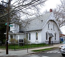
College Point is a working-middle-class neighborhood in the New York City borough of Queens. It is bounded to the south by Whitestone Expressway and Flushing; to the east by 138th Street and Malba/Whitestone; to the north by the East River; and to the west by Flushing Bay. [4] College Point is a mostly residential ethnically diverse community with some industrial areas. The neighborhood is served by several parks and contains two yacht clubs.
College Point is located in Queens Community District 7 and its ZIP Code is 11356. [1] It is patrolled by the New York City Police Department's 109th Precinct. [5] Politically, College Point is represented by the New York City Council's 19th District. [6]
College Point was named for St. Paul's College, an Episcopalian seminary founded in 1835 by the Rev. William Augustus Muhlenberg. [7] [8] [9] The college closed around 1850, but the name remained. Former names include Lawrence's Neck, Tew's Neck, Flammersberg, and Strattonsport. [10]
The original European settler of this area was Captain William Lawrence. [11] He was also the largest landholder of the original incorporators of the Town of Flushing, now in Queens. He arrived in America on the sailing ship Planter in the 1630s. Lawrence married the oldest daughter of Richard "Bull Rider" Smith, who founded Smithtown on Long Island. He and his wife had a son, William Jr., who married the Richard Smiths' youngest granddaughter.
In 1854 the German-American industrialist Conrad Poppenhusen arrived; he was already a prosperous manufacturer in Brooklyn of hard rubber goods and expanded his operation to this small farming community. College Point became a factory town primarily for his workers, most of them also German immigrants, and the tycoon became a philanthropist, contributing to churches, libraries, and the Poppenhusen Institute, an educational beacon of College Point. [7] [12] Poppenhusen is responsible for the first free kindergarten in America. He connected College Point to Flushing by the Whitestone Branch of the Flushing and North Side Railroad. A monument on College Point Boulevard, one of the main streets in College Point, stands testament to Poppenhusen. [13]
College Point became a center for breweries and day trip resorts, and in the 1930s shifted towards the manufacturing of airplane parts. [14] Until the mid-20th century, the partially infilled Mill Creek separated College Point from the rest of Queens. [15] College Point was a peninsula connected to the rest of Queens by four roads: College Point Boulevard, Linden Place, 20th Avenue, and 14th Avenue; all except the last crossed Mill Creek. [16]
Flushing Airport opened in the neighborhood in 1927. [17] Throughout its tenure, the airport was troubled by its proximity to the larger LaGuardia Airport, neighborhood opposition due to noise and accidents, and flooding on the runways. [18] [19] Its main clientele were private airplanes and blimps. [20] Whenever northwest or southwest winds rose above 35 miles per hour, the runways would not operate. Lacking proper lighting, the runway also never allowed for nighttime usage.
In 1926, approximately 100 single-family and two-family houses were built on the Graham estate. [21] In 1938, the 6 acres (2.4 ha) estate of Anna Schlesinger, near Ninth Avenue and 119th Street, was sold to the Daniel Corners Realty Corporation. [22] The land had previously been part of the Poppenhusen estate. [22] The Daniel Corners Realty Corporation bought the land to build fifty homes on the land, which it called College Estates. [22] Arthur Allen was the architect of the houses. [22]
In 1925, Earl Dodge Osborn gave his initials to the Edo Aircraft Corporation. The company was known for building and testing seaplanes and aircraft floats. [14]
In 1953, the Fleet Street Company sold 108 Cape Cod-style homes for $13,500 near 25th Avenue and 126th Street. [23] The architect of the homes was Alwin Cassens Jr. [23] The development was called Allied Homes. [23]
College Point Industrial Park, a commercial area and business park, was first proposed for College Point in 1960. The site, initially 300 acres (120 ha), was bounded by Whitestone Expressway on the southeast, 15th Avenue on the north, and 127th Street on the west. The site was chosen because it was the largest suitable tract that was not on Staten Island, which was considered to be too remote from the rest of New York City. [24] The proposal languished for several years before being revived in 1967. [25] By the 1970s, the Adventure's Inn Amusement Park was being operated on part of the 565-acre (229 ha) complex. [26] The city condemned the amusement park site in 1973 due to nuisance complaints. [27] The next year, the industrial park was founded on a site of 550 acres (220 ha). The complex was later rebranded the College Point Corporate Park (CPCP) because there had been few industrial tenants there. [28]
Flushing Airport was decommissioned in 1984. [29] Much of Linden Place in College Point was also closed due to frequent flooding near the airport, which had been built on a wetland atop Mill Creek. [30] [31] There were several proposals to redevelop the airport site, none of which were successful. [32] One plan in 1986 called for the site to be redeveloped as a large heliport, [33] though the project ultimately failed seven years later. [34] Several large development projects were constructed around the airport site in the late 1980s. These buildings included three projects inside the CPCP campus, as well as another building at Linden Place and 31st Road. Floor space in these buildings rented out at an average of $10 per square foot ($110/m2), a relatively expensive rate at the time. This was due to its proximity to major transportation connections such as the LaGuardia Airport and the Bronx–Whitestone Bridge, as well as the lack of parking in nearby downtown Flushing. [35]
By 1994, the CPCP had over 100 companies. [36] The CPCP proposed to develop a strip mall with large "mega-stores" on 20th Avenue, though this idea was initially opposed by local residents. [37] The strip mall was developed by The Related Companies [28] and opened in 1998; [38] it contains a Waldbaum's, Target, BJ's Wholesale Club, and other stores. [39] When the strip mall opened, there were plans to reopen Linden Place. [38] In 1999, Triangle Equities developed a Multiplex cinema with two stores in College Point, on a site bounded by Ulmer Street, 28th Avenue, Linden Place, and Whitestone Expressway. Other large projects included a new factory for Crystal Windows and Door Systems next to the Whitestone Expressway. [28] The printing plant for The New York Times , which opened on the Whitestone Expressway in 1997, enabled the newspaper to expand its nationwide distribution. [40] Also in 1997, the Queens Historical Society bestowed a "Queensmark" award on College Point, in hopes of encouraging historical preservation of local landmark architecture. [41]
There was an increase in residential development in the 1990s and 2000s; a New York Times article in March 2002 stated that 450 residential units had been developed in the previous 14 months. [7] The following year, the Times reported that the corporate park had more than 200 companies. [42] There were proposals to redevelop the Flushing Airport site as a wholesalers' complex in the early 2000s, but these were protested by College Point residents. [43] The northern shoreline of College Point, a former oil lagoon, was designated a federal Superfund cleanup site in 2010. [44]
Groundbreaking for a new New York City Police Academy at College Point occurred in December 2009, [45] and Phase One opened in December 2015. [46] After several delays, Linden Place was finally renovated in the 2010s so that it would be several feet above the Flushing Airport Wetlands. The first portion of Linden Place reopened in 2015, and the remaining section was set to reopen in 2022. [30]
Though College Point is today mainly residential, it also contains significant commercial presence, as well as remnants of a once-active industrial community. [7] [39] Especially in the southern part of the neighborhood, there are many industrial and light commercial businesses, including what The New York Times described as "oil storage facilities, a cement plant, a Pepsi-Cola distribution facility, furniture warehouses and contractors and other small businesses". [7] The northern shoreline was redeveloped as a medium-density residential area starting in the 1980s. However, College Point's other residences consist largely of single-family homes from the 1920s. [39]
Based on data from the 2020 United States Census, the population of College Point was 33,625, an increase of 5,379 (19.0%) from the 28,246 counted in 2010. [3] In 2010, the neighborhood covered an area of 1,148.84 acres (464.92 ha) and had a population density of 21.1 inhabitants per acre (13,500/sq mi; 5,200/km2). [2]
The racial makeup of the neighborhood was 40.1% (13,471) Hispanic/Latino (of any race), 34.3% (11,525) Asian non-Hispanic, 21.3% (7,176) White non-Hispanic, 2.0% (687) Black non-Hispanic, 0.7% (244) from some other race non-Hispanic, and 1.6% (522) non-Hispanic of two or more races. [3]
The entirety of Community Board 7, which comprises Flushing, College Point, and Whitestone, had 263,039 inhabitants as of NYC Health's 2018 Community Health Profile, with an average life expectancy of 84.3 years. [47] : 2, 20 This is longer than the median life expectancy of 81.2 for all New York City neighborhoods. [48] : 53 (PDF p. 84) [49] Most inhabitants are middle-aged and elderly: 22% are between the ages of between 25 and 44, 30% between 45 and 64, and 18% over 65. The ratio of youth and college-aged residents was lower, at 17% and 7% respectively. [47] : 2
As of 2017, the median household income in Community Board 7 was $51,284. [50] In 2018, an estimated 25% of College Point and Flushing residents lived in poverty, compared to 19% in all of Queens and 20% in all of New York City. One in seventeen residents (6%) were unemployed, compared to 8% in Queens and 9% in New York City. Rent burden, or the percentage of residents who have difficulty paying their rent, is 57% in College Point and Flushing, lower than the boroughwide and citywide rates of 53% and 51% respectively. Based on this calculation, as of 2018 [update] , College Point and Flushing are considered to be high-income relative to the rest of the city and not gentrifying. [47] : 7
Flushing, College Point, and Whitestone are patrolled by the 109th Precinct of the NYPD, located at 37-05 Union Street. [5] The 109th Precinct ranked 9th safest out of 69 patrol areas for per-capita crime in 2010. [51] As of 2018 [update] , with a non-fatal assault rate of 17 per 100,000 people, College Point and Flushing's rate of violent crimes per capita is less than that of the city as a whole. The incarceration rate of 145 per 100,000 people is lower than that of the city as a whole. [47] : 8
The 109th Precinct has a lower crime rate than in the 1990s, with crimes across all categories having decreased by 83.7% between 1990 and 2018. The precinct reported 6 murders, 30 rapes, 202 robberies, 219 felony assaults, 324 burglaries, 970 grand larcenies, and 126 grand larcenies auto in 2018. [52]
A large New York City Police Academy campus was built near 28th Avenue and College Point Boulevard, [53] opening in December 2015. [54]
College Point contains a New York City Fire Department (FDNY) fire station, Engine Co. 297/Ladder Co. 130, at 119-11 14th Road. [55] [56]
As of 2018 [update] , preterm births and births to teenage mothers are less common in College Point and Flushing than in other places citywide. In College Point and Flushing, there were 63 preterm births per 1,000 live births (compared to 87 per 1,000 citywide), and 8 births to teenage mothers per 1,000 live births (compared to 19.3 per 1,000 citywide). [47] : 11 College Point and Flushing have a higher than average population of residents who are uninsured. In 2018, this population of uninsured residents was estimated to be 14%, slightly higher than the citywide rate of 12%. [47] : 14
The concentration of fine particulate matter, the deadliest type of air pollutant, in College Point and Flushing is 0.0073 milligrams per cubic metre (7.3×10⁻⁹ oz/cu ft), less than the city average. [47] : 9 Thirteen percent of College Point and Flushing residents are smokers, which is lower than the city average of 14% of residents being smokers. [47] : 13 In College Point and Flushing, 13% of residents are obese, 8% are diabetic, and 22% have high blood pressure—compared to the citywide averages of 22%, 8%, and 23% respectively. [47] : 16 In addition, 15% of children are obese, compared to the citywide average of 20%. [47] : 12
Ninety-five percent of residents eat some fruits and vegetables every day, which is higher than the city's average of 87%. In 2018, 71% of residents described their health as "good", "very good", or "excellent", lower than the city's average of 78%. [47] : 13 For every supermarket in College Point and Flushing, there are 6 bodegas. [47] : 10
The nearest major hospitals are NewYork–Presbyterian/Queens and Flushing Hospital Medical Center. [57]
College Point is covered by the ZIP Code 11356. [58] The United States Post Office operates two post offices nearby:
College Point and Flushing generally have a similar rate of college-educated residents to the rest of the city as of 2018 [update] . While 37% of residents age 25 and older have a college education or higher, 23% have less than a high school education and 40% are high school graduates or have some college education. By contrast, 39% of Queens residents and 43% of city residents have a college education or higher. [47] : 6 The percentage of College Point and Flushing students excelling in math rose from 55% in 2000 to 78% in 2011, and reading achievement rose from 57% to 59% during the same time period. [61]
College Point and Flushing's rate of elementary school student absenteeism is less than the rest of New York City. In College Point and Flushing, 9% of elementary school students missed twenty or more days per school year, lower than the citywide average of 20%. [48] : 24 (PDF p. 55) [47] : 6 Additionally, 86% of high school students in College Point and Flushing graduate on time, more than the citywide average of 75%. [47] : 6
Public elementary schools, defined as kindergarten through 5th grades, include PS 29 and PS 129. College Point is home to St. Fidelis Parish, founded in 1856. The present church was completed in 1906. Adjacent to the church is the grave of Father Huber, the founding pastor. For over 150 years, the parish conducted an elementary school including kindergarten through 8th grades. In 1924, St. Fidelis School, a three-story building of 18 classrooms, opened its doors on the present 14th Avenue and 124th Street. In 1961, the 12 classroom annex was opened. In its heyday, St. Fidelis School had almost two thousand students, from kindergarten through grade 8. When it closed, there were just over 200 students. During all of these years, it was staffed by the Dominican Sisters of Amityville (Dominican Sisters of the American Congregation of the Holy Cross). Due to significant demographic changes in College Point, the elementary school was finally closed in June 2013.
Up until Vatican II, St. Fidelis was a thriving parish. For many years, it was led by Father (and eventually Monsignor) William J. Osborne. Monsignor Osborne died in 1998 at the age of 102, the oldest living Catholic priest in the United States at the time. In the 1950s and 1960s, there were four daily masses in St. Fidelis Parish, as well as ten Sunday masses in three venues. Currently, with diminished enrollments and changing demographics, there is one daily mass, and four Sunday masses, one in Spanish.
St. Agnes Academic High School, a private Catholic high and independent of St. Fidelis parish, had been operating for over one hundred years. In its early years, it was very briefly co-educational, but it ultimately was restricted to girls. It was owned and staffed by the Dominican Sisters of Amityville, assisted by lay men and women. For many years, Reverend Mother Agatha, O.P., was superior and principal of St. Agnes High School. The Dominican Sisters reside in Saint Agnes Convent as well as the Harbor of Grace Convent, which was the original convent for this community. In June 2018, The Harbor of Grace Convent permanently closed, since the Diocese of Brooklyn wished to reclaim the building. The Harbor of Grace, first opened in the early 1970s, with Sr. Julianne (Nora Daniel) Connolly, O.P. being one of its pioneers. Sister Julianne had lived there for its entire history until it was closed permanently in 2018. St. Agnes Convent, the last of the Dominican Convents in College Point, closed in 2019. St Agnes Convent, the landmark of "High Street" for almost two centuries, then faced the wrecker ball and by November, 2022, this historical edifice was completely gone. In June 2021, St. Agnes High School closed permanently. Financial factors, significant changes in demographics and the toll of COVID-19 were factors leading to this decision. For the first time in nearly two centuries, no Catholic school was operating within College Point / the St Fidelis parish complex, and the Dominican Sisters, and their convents, are gone forever. Given the diminishing number of Catholics in North Queens, it is probable that the parish of St Fidelis will merge with Holy Trinity and St Luke's parish in the not too distant future. By 2022, the church building as well as the rectory, housing the parish priests, are the only remaining and functioning structures of the parish complex.
St. Fidelis Roman Catholic Church, [62] St. John's Lutheran, and The First Reformed Church of College Point host the community's three largest congregations.
The Queens Public Library's Poppenhusen branch is located at 121-23 14th Avenue. [63]
Flushing Airport, opened in 1927 along the shore of Flushing Bay, had been a busy aviation hub before LaGuardia Airport was built in 1939 about one mile away. It carried the IATA code FLU. In 1977, a Piper Twin Comanche crashed shortly after taking off from the airport. The incident eventually led to the closing of this airport in 1984. [17] The site remains abandoned, although plans have been proposed over the years to convert it into a blimp-port or office park. [76]
The printing plant for The New York Times is located in College Point as well, along the Whitestone Expressway just east of the former airport. [77] [78]
The Tallman Island Wastewater Treatment Plant is located at 127th Street near Powell's Cove. Tallman Island was formerly a separate island, but was fused to College Point in the mid-20th century. [79] The island formerly contained a small resort with a hotel and dancing and dining pavilions until the 1930s. The wastewater plant was erected between 1937 and 1939, and was dedicated in April 1939. [80]
MTA Regional Bus Operations' Q20A , Q20B , Q25 , Q50 , Q65 , Q76 , QM2 , QM20 , QM32 lines serve the neighborhood. [81] No New York City Subway lines have ever been built to the area, although a spur from the IRT Flushing Line (present-day 7 and <7> trains) was proposed during much of the early 20th century. [82] : 371 The Long Island Rail Road's Whitestone Branch used to run through the area [83] until it closed in 1932. [84]
Notable current and former residents of College Point include:
St. Albans is a residential neighborhood in the southeastern portion of the New York City borough of Queens. It is bordered by Jamaica to the northwest, Hollis to the north, Queens Village to the northeast, Cambria Heights to the east, Laurelton to the southeast, Springfield Gardens to the south, and South Jamaica to the southwest. St. Albans is centered on the intersection of Linden Boulevard and Farmers Boulevard, about two miles north of John F. Kennedy International Airport.
Flushing is a neighborhood in the north-central portion of the New York City borough of Queens. The neighborhood is the fourth-largest central business district in New York City. Downtown Flushing is a major commercial and retail area, and the intersection of Main Street and Roosevelt Avenue at its core is the third-busiest in New York City, behind Times Square and Herald Square.
Corona is a neighborhood in the borough of Queens in New York City. It borders Flushing and Flushing Meadows–Corona Park to the east, Jackson Heights to the west, Forest Hills and Rego Park to the south, Elmhurst to the southwest, and East Elmhurst to the north. Corona's main thoroughfares include Corona Avenue, Roosevelt Avenue, Northern Boulevard, Junction Boulevard, and 108th Street.
The Flushing–Main Street station is the eastern terminal on the IRT Flushing Line of the New York City Subway, located at Main Street and Roosevelt Avenue in Downtown Flushing, Queens. It is served by the 7 local train at all times and the <7> express train during rush hours in the peak direction.
The Mets–Willets Point station is a rapid transit station on the IRT Flushing Line of the New York City Subway. Located near the Citi Field baseball stadium, it is served by the 7 train at all times and by the express <7> train during rush hours in the peak direction or after sporting events. This station is located near Flushing Meadows–Corona Park in Willets Point, Queens, on Roosevelt Avenue between 114th and 126th Streets.
The Cross Island Parkway is a controlled-access parkway in New York City and Nassau County, part of the Belt System of parkways running along the perimeter of the boroughs of Queens and Brooklyn. The Cross Island Parkway runs 10.6 miles (17.1 km) from the Whitestone Expressway in Whitestone past the Throgs Neck Bridge, along and across the border of Queens and Nassau County to meet up with the Southern State Parkway, acting as a sort of separation point which designates the limits of New York City. The road is designated as New York State Route 907A (NY 907A), an unsigned reference route, and bears the honorary name 100th Infantry Division Parkway.
Woodside is a residential and commercial neighborhood in the western portion of the borough of Queens in New York City. It is bordered on the south by Maspeth, on the north by Astoria, on the west by Sunnyside, and on the east by Elmhurst, Jackson Heights, and East Elmhurst. Some areas are widely residential and very quiet, while other parts, especially the ones around Roosevelt Avenue, are busier.
Fresh Meadows is a neighborhood in the northeastern section of the New York City borough of Queens. Fresh Meadows used to be part of the broader town of Flushing and is bordered to the north by the Horace Harding Expressway and Auburndale; to the west by Pomonok, St. John's University, Hillcrest, and Utopia; to the east by Cunningham Park and the Clearview Expressway; and to the south by the Grand Central Parkway.
Interstate 678 (I-678) is a north–south auxiliary Interstate Highway that extends for 14 miles (23 km) through two boroughs of New York City. The route begins at John F. Kennedy International Airport on Jamaica Bay and travels north through Queens and across the East River to the Bruckner Interchange in the Bronx, where I-678 ends and the Hutchinson River Parkway begins.
The IRT Flushing Line is a rapid transit route of the New York City Subway system, named for its eastern terminal in Flushing, Queens. It is operated as part of the A Division. The Interborough Rapid Transit Company (IRT), a private operator, had constructed the section of the line from Flushing, Queens, to Times Square, Manhattan between 1915 and 1928. A western extension was opened to Hudson Yards in western Manhattan in 2015, and the line now stretches from Flushing to Chelsea, Manhattan. It carries trains of the 7 local service, as well as the express <7> during rush hours in the peak direction. It is the only currently operational IRT line to serve Queens.
Whitestone is a residential neighborhood in the northernmost part of the New York City borough of Queens. The neighborhood proper is located between the East River to the north; College Point and Whitestone Expressway to the west; Flushing and 25th Avenue to the south; and Bayside and Francis Lewis Boulevard to the east.
Ridgewood is a neighborhood in the New York City borough of Queens. It borders the Queens neighborhoods of Maspeth to the north, Middle Village to the east, and Glendale to the southeast, as well as the Brooklyn neighborhoods of Bushwick to the southwest and East Williamsburg to the west. Historically, the neighborhood straddled the Queens-Brooklyn boundary.
Queens Botanical Garden is a botanical garden located at 43-50 Main Street in Flushing, Queens, New York City. The 39-acre (16 ha) site features rose, bee, herb, wedding, and perennial gardens; an arboretum; an art gallery; and a LEED-certified Visitor & Administration Building. Queens Botanical Garden is located on property owned by the City of New York, and is funded from several public and private sources. It is operated by Queens Botanical Garden Society, Inc.
East Elmhurst is a residential neighborhood in the northwest section of the New York City borough of Queens. It is bounded to the south by Jackson Heights and Corona, to the north and east by Bowery Bay, and to the west by Woodside and Ditmars Steinway. The area also includes LaGuardia Airport, located on the shore of Flushing Bay, LaGuardia Landing Lights Fields, and Astoria Heights.
The Flushing River, also known as Flushing Creek, is a waterway that flows northward through the borough of Queens in New York City, mostly within Flushing Meadows–Corona Park, emptying into the Flushing Bay and the East River. The river runs through a valley that may have been a larger riverbed before the last Ice Age, and it divides Queens into western and eastern halves. Until the 20th century, the Flushing Creek was fed by three tributaries: Mill Creek and Kissena Creek on the eastern bank, and Horse Brook on the western bank.
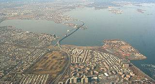
Bay Terrace is a neighborhood in the northeastern section of the New York City borough of Queens. It is often considered part of the larger area of Bayside. Bay Terrace overlooks the East River and the approaches to the Throgs Neck Bridge from the Clearview Expressway and Cross Island Parkway. It is bounded on the west by the Clearview Expressway, on the south by 26th and 28th Avenues, to the east by the Little Neck Bay, and to the north by the East River.
College Point Fields is a public park in College Point, Queens, New York City. It is bounded by Ulmer and 130th Streets to the west, 23rd Avenue to the north, Linden Place to the east, and 26th Avenue and the remains of Mill Creek to the south. The park contains two fields each for Little League Baseball and regular baseball; a soccer field; a roller hockey rink; and bleachers.
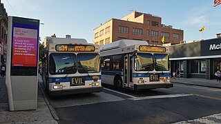
The Q25 and Q34 bus routes constitute a public transit line in Queens, New York City. The south-to-north route runs primarily on Parsons Boulevard and Kissena Boulevard, serving two major bus-subway hubs: Sutphin Boulevard–Archer Avenue–Jamaica and Flushing–Main Street. The Q25 terminates in College Point, and the Q34 in Whitestone, both in northern Queens.
The Q20A and Q20B and Q44 bus routes constitute the Main Street Line, a public transit line in Queens, New York City, running primarily along Main Street between two major bus-subway hubs in the neighborhoods of Jamaica and Flushing. The Q20A/B terminates in College Point at the north end of Queens. The Q44 continues north into the borough of the Bronx, terminating in the West Farms neighborhood near the Bronx Zoo. The Q44 is one of two Queens bus routes to operate between the two boroughs.
{{cite web}}
: CS1 maint: numeric names: authors list (link){{cite web}}
: CS1 maint: unfit URL (link)