Bellerose, Queens

Last updated
Bellerose
MTA Hillside Av East 03.jpg
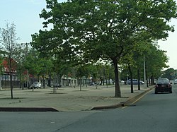
Wide, tree-lined median on Hillside Avenue
Bellerose, Queens
Location within New York City
Coordinates: 40°44′06″N73°43′12″W / 40.735°N 73.72°W / 40.735; -73.72
Country Flag of the United States.svg  United States
State Flag of New York.svg  New York
City Flag of New York City.svg  New York City
County/Borough Flag of Queens County, New York.svg Queens
Community District Queens 13 [1]
Time zone UTC−5 (EST)
  Summer (DST) UTC−4 (EDT)
ZIP Code
11426
Area codes 718, 347, 929, and 917

Bellerose is an ethnically diverse, middle-class neighborhood on the eastern edge of the New York City borough of Queens, along the border of Queens and Nassau County, Long Island. It is adjacent to Bellerose Village and Bellerose Terrace in Nassau County, from which it is separated by Jericho Turnpike. The northern edge of Bellerose is separated from another part of the Nassau border by the neighborhood of Floral Park, Queens to the east, divided by Little Neck Parkway.

Contents

The neighborhood consists predominantly of detached houses with mostly middle-class Indian American and European American populations. While the northeastern section of Queens Village is sometimes referred to as part of Bellerose, it is also called Bellerose Manor, which is recognized by the U.S. Postal Service as an "acceptable alternate" to Queens Village and Jamaica in postal addresses. [2]

Bellerose is located in Queens Community District 13 and its ZIP Code is 11426. [1] It is patrolled by the New York City Police Department's 105th Precinct.

Demographics

Based on data from the 2010 United States Census, the population of Bellerose was 25,287, an increase of 823 (3.4%) from the 24,464 counted in 2000. Covering an area of 1,258.85 acres (509.44 ha), the neighborhood had a population density of 20.1 inhabitants per acre (12,900/sq mi; 5,000/km2). [3]

The racial makeup of the neighborhood in 2010 was 31.5% (7,974) White, 7.4% (1,882) African American, 0.2% (61) Native American, 38.8% (9,821) Asian, 0.2% (41) Pacific Islander, 2.0% (494) from other races, and 3.7% (936) from two or more races. Hispanic or Latino of any race were 16.1% (4,078) of the population. [4]

Education

Bellerose's public schools are operated by the New York City Department of Education. It is mostly part of District 26 but some areas are in District 29. The neighborhood's nearest high school is Martin Van Buren High School in Queens Village.

The Queens Public Library operates the Bellerose branch at 250-06 Hillside Avenue. [5]

Transportation

The New York City Bus system serves Bellerose on the Q43 and X68 on Hillside Avenue. Buses on Union Turnpike include the Q46 , QM6 and QM36. The Q36 bus on Jamaica Avenue. The Q1 bus on Braddock Avenue. It is also served by Nassau Inter-County Express on the n22 , n24 and n26. Hillside Avenue, Jamaica Avenue, and Union Turnpike are the major east–west arteries. The Cross Island Parkway serves as the major north–south artery.

The closest railroad stations are the Bellerose station and the Elmont station, located outside the city limits on the Hempstead Branch of the Long Island Rail Road. [6] [7]

Notable people

Related Research Articles

<span class="mw-page-title-main">Elmont, New York</span> Hamlet and census-designated place in New York, United States

Elmont is an unincorporated hamlet and census-designated place (CDP) located in northwestern Hempstead in Nassau County, New York, United States, along its border with the borough of Queens in New York City. The population was 35,265 as of the 2020 census.

<span class="mw-page-title-main">Floral Park, New York</span> Village in New York, United States

Floral Park is an incorporated village in Nassau County, on Long Island, in New York, United States. The population was 16,172 at the time of the 2020 census.

<span class="mw-page-title-main">Jamaica, Queens</span> Neighborhood in New York City

Jamaica is a neighborhood in the New York City borough of Queens. It is mainly composed of a large commercial and retail area, though part of the neighborhood is also residential. Jamaica is bordered by Hollis to the east; St. Albans, Springfield Gardens, Rochdale Village to the southeast; South Jamaica to the south; Richmond Hill and South Ozone Park to the west; Briarwood to the northwest; and Kew Gardens Hills, Jamaica Hills, and Jamaica Estates to the north.

<span class="mw-page-title-main">Queens Village, Queens</span> Neighborhood of Queens in New York City

Queens Village is a mostly residential middle class neighborhood in the eastern part of the New York City borough of Queens. It is bound by Hollis to the west, Cambria Heights to the south, Bellerose, Queens and Elmont, Nassau County to the east, and Oakland Gardens to the north.

<span class="mw-page-title-main">Cross Island Parkway</span> Highway in New York

The Cross Island Parkway is a controlled-access parkway in New York City, part of the Belt System of parkways running along the perimeter of the boroughs of Queens and Brooklyn. The Cross Island Parkway runs 10.6 miles (17.1 km) from the Whitestone Expressway in Whitestone past the Throgs Neck Bridge, along and across the border of Queens and Nassau County to meet up with the Southern State Parkway, acting as a sort of separation point which designates the limits of New York City. The road is designated as New York State Route 907A (NY 907A), an unsigned reference route, and bears the honorary name 100th Infantry Division Parkway.

<span class="mw-page-title-main">New York State Route 25</span> Highway in New York

New York State Route 25 (NY 25) is an east–west state highway in downstate New York in the United States. The route extends along the central parts and North Shore of Long Island for just over 105 miles (169 km) from east midtown Manhattan in New York City to the Cross Sound Ferry terminal at Orient Point on the end of Long Island's North Fork. NY 25 is carried from Manhattan to Queens by way of the double-decked Queensboro Bridge over the East River.

<span class="mw-page-title-main">Laurelton, Queens</span> Neighborhood of Queens in New York City

Laurelton is a largely middle-class neighborhood in the New York City borough of Queens and part of the former town of Jamaica. Merrick Boulevard, which bisects the community in a generally east–west direction, forms its commercial spine. It is bounded by Springfield Boulevard to the west, 121st Avenue to the north, Laurelton Parkway to the east, and Conduit Avenue to the south.

<span class="mw-page-title-main">Cambria Heights, Queens</span> Neighborhood of Queens in New York City

Cambria Heights is a residential neighborhood in the southeastern portion of the New York City borough of Queens. It is bounded by Springfield Boulevard and Francis Lewis Boulevard to the west, the Elmont, Nassau County border on the east, Queens Village to the north, St. Albans to the west, and Montefiore Cemetery and Laurelton, Springfield Gardens, and Rosedale to the south. As of 2010, Cambria Heights's population was 18,677. The neighborhood is part of Queens Community Board 13.

<span class="mw-page-title-main">Grand Central Parkway</span> Highway in New York

The Grand Central Parkway (GCP) is a 14.61-mile (23.51 km) controlled-access parkway that stretches from the Triborough Bridge in New York City to Nassau County on Long Island. At the Queens–Nassau border, it becomes the Northern State Parkway, which runs across the northern part of Long Island through Nassau County and into Suffolk County, where it ends in Hauppauge. The westernmost stretch also carries a short stretch of Interstate 278 (I-278). The parkway runs through Queens and passes the Cross Island Parkway, Long Island Expressway, LaGuardia Airport and Citi Field, home of the New York Mets. The parkway is designated New York State Route 907M (NY 907M), an unsigned reference route. Despite its name, the Grand Central Parkway was not named after Grand Central Terminal.

<span class="mw-page-title-main">New York State Route 25B</span> State highway on Long Island in New York, US

New York State Route 25B (NY 25B) is a 7.25-mile (11.67 km) east–west state highway located on Long Island in New York, United States. The western terminus of the route is at an intersection with NY 25 in Queens. The eastern terminus is at an interchange with NY 25 in Westbury, Nassau County. NY 25B is named Hillside Avenue for its entire length, except for a 0.69-mile (1.11 km) portion in the village of East Williston, where it is called East Williston Avenue and owned & maintained by Nassau County as the unsigned County Route 85.

<span class="mw-page-title-main">New York State Route 24</span> Highway in New York

New York State Route 24 (NY 24) is a 30.84-mile-long (49.63 km) east–west state highway on Long Island in the U.S. state of New York. The highway is split into two segments, with the longer and westernmost of the two extending 18.68 miles (30.06 km) from an interchange with Interstate 295 and NY 25 in the Queens Village section of the New York City borough of Queens to an intersection with NY 110 in East Farmingdale in the Suffolk County town of Babylon. The shorter eastern section, located in eastern Suffolk County, extends 12.16 miles (19.57 km) from an interchange with I-495 in Calverton to an intersection with County Route 80 (CR 80) in Hampton Bays.

<span class="mw-page-title-main">Jamaica Estates, Queens</span> Neighborhood of Queens in New York City

Jamaica Estates is a neighborhood in the New York City borough of Queens. Jamaica Estates is part of Queens Community District 8 and located in the northern portion of Jamaica. It is bounded by Union Turnpike to the north, Hillside Avenue to the south, Utopia Parkway and Homelawn Street to the west, and 188th Street to the east. The main road through the neighborhood is Midland Parkway.

<span class="mw-page-title-main">Union Turnpike (New York)</span> Boulevard in Queens and Nassau County, New York

Union Turnpike is a thoroughfare stretching across part of Long Island in southern New York state, mostly within central and eastern Queens in New York City. It runs from Myrtle Avenue in Glendale, Queens, to Marcus Avenue in North New Hyde Park, Nassau County, about 1 mile (1.6 km) outside New York City border.

The Q79 bus route constituted a public transit line in Queens, New York City. It ran primarily along Little Neck Parkway between Little Neck station and Jamaica Avenue. Service on the route, initially known as the Q12A, began on June 4, 1950, following a request made by Queens Borough President Maurice A. FitzGerald. In 1990, the route was renumbered the Q79. In 1996, the Metropolitan Transportation Authority proposed extending the route to Floral Park, but this extension was canceled to community opposition. This route was operated by the New York City Transit brand until June 27, 2010, when it was discontinued under system-wide service cuts.

<span class="mw-page-title-main">Glen Oaks, Queens</span> Neighborhood of Queens in New York City

Glen Oaks is the easternmost neighborhood of the New York City borough of Queens. The neighborhood is part of Queens Community Board 13,< and borders Nassau County to the east.

<span class="mw-page-title-main">Jamaica Avenue</span> Avenue in Brooklyn and Queens, New York

Jamaica Avenue is a major avenue in the New York City boroughs of Brooklyn and Queens, New York, in the United States. Jamaica Avenue's western end is at Broadway and Fulton Street, as a continuation of East New York Avenue, in Brooklyn's East New York neighborhood. Physically, East New York Avenue connects westbound to New York Avenue, where East New York Avenue changes names another time to Lincoln Road; Lincoln Road continues to Ocean Avenue in the west, where it ends. Its eastern end is at the city line in Bellerose, Queens, where it becomes Jericho Turnpike to serve the rest of Long Island. The section of Jamaica Avenue designated as New York State Route 25 runs from Braddock Avenue to the city line, where Jamaica Avenue becomes Jericho Turnpike.

<span class="mw-page-title-main">Little Neck Parkway</span> Boulevard in Queens, New York

Little Neck Parkway (formerly Little Neck Road) is the easternmost, major north–south route in the northern portion of the New York City borough of Queens, traveling between the neighborhoods of Little Neck and Bellerose.

<span class="mw-page-title-main">Q111, Q113, and Q114 buses</span> Bus routes in Queens, New York

The Q111, Q113, and Q114 bus routes constitute a public transit line between the Jamaica and Far Rockaway neighborhoods of Queens, New York City, running primarily along Guy R. Brewer Boulevard. The Q113 and Q114 provide limited-stop service between Jamaica and Far Rockaway, connecting two major bus-subway hubs, and crossing into Nassau County. The Q111 provides local service exclusively within Queens, with the exception of select rush-hour trips to or from Cedarhurst in Nassau County. Some of the last bus routes to be privately operated in the city, they are currently operated by the MTA Bus Company brand of MTA Regional Bus Operations. The Q113 and Q114 are one of the few public transit options between the Rockaway peninsula and "mainland" New York City.

Frank P. LoCicero Triangle is a 250-square-foot (23 m2) triangular public green space located in the Bellerose neighborhood of Queens, New York. It is named in honor of local resident Frank P. LoCicero (1918-1997) who lived in the area from 1950 until his death. In the years between, LoCicero was an active member and later president of the Bellerose Hillside Civic Association, which fought to maintain the suburban character of the neighborhood.

<span class="mw-page-title-main">Hillside Avenue buses</span> Bus routes in Queens, New York

The Q1, Q36, and Q43 bus routes constitute a public transit line in Queens, New York City. The routes run primarily along Hillside Avenue from the Jamaica, Queens commercial and transportation hub towards several eastern Queens neighborhoods on the city border with Nassau County. Originally operated by the North Shore Bus Company until 1947, all three routes are now operated by MTA Regional Bus Operations under the New York City Transit brand.

References

  1. 1 2 "NYC Planning | Community Profiles". communityprofiles.planning.nyc.gov. New York City Department of City Planning. Retrieved April 7, 2018.
  2. Bellerose Manor: In a Tale of Pride and ZIP Codes, One Digit Makes All the Difference, The New York Times , September 14, 2003; accessed December 21, 2011
  3. Table PL-P5 NTA: Total Population and Persons Per Acre - New York City Neighborhood Tabulation Areas*, 2010, Population Division - New York City Department of City Planning, February 2012. Accessed June 16, 2016.
  4. Table PL-P3A NTA: Total Population by Mutually Exclusive Race and Hispanic Origin - New York City Neighborhood Tabulation Areas*, 2010, Population Division - New York City Department of City Planning, March 29, 2011. Accessed June 14, 2016.
  5. "Branch Detailed Info: Bellerose". Queens Library. Retrieved March 7, 2019.
  6. Bellerose station, Long Island Rail Road. Accessed August 3, 2017.
  7. "Elmont Station-UBS Arena". Long Island Rail Road . Retrieved February 14, 2023.
  8. Provencio, Phil. "Up Next, Ted Alexandro: A Look Through the Lens at New York Comedy", The Interrobang, May 11, 2017. Accessed February 3, 2020. "I grew up in Queens in a town called Bellerose. So NY has been home pretty much my entire life.... Part of growing up in Queens is feeling a bit like a stepchild, just outside the magic kingdom."
  9. Heins, Scott. "Anthony Bourdain's Journey Through Queens Is A Celebration Of The American Dream" Archived 2020-02-03 at the Wayback Machine , Gothamist , May 22, 2017. Accessed February 3, 2020. "As Heems (who grew up in Glen Oaks and Bellerose) said, if the American dream is alive, it's alive in Queens—where nearly half of residents are foreign born."
  10. Horowitz, Mitch. "My Father Fought the Sex Pistols", Medium, June 4, 2018. Accessed December 23, 2023. "In 1977, we moved from our bungalowed Queens neighborhood of Bellerose to the supposedly safer and rosier environs of New Hyde Park, about three miles east."
  11. Lii, Jane H. "2 Suits Slow Plans for a Speedier Long Island Expressway", The New York Times , July 14, 1996. Accessed December 24, 2023. "Mr. Padavan, a Republican from Bellerose, said: 'The H.O.V. lanes end at Cross Island Parkway. What we are looking at is bottlenecking there.'"
  12. Litsky, Frank. "Jack Rohan, Former Coach of Columbia Basketball, Dies at 72", The New York Times , September 11, 2004. Accessed February 3, 2020. "John Patrick Rohan was born Aug. 25, 1931, in the Floral Park section of Queens, and was raised in Bellerose."
  13. Post, Leonard. "Indicted And Defiant / Radical attorney Lynne Stewart stand accused of abetting terrorists. Her response: 'Emphatically not guilty.'", Newsday , June 2, 2002. Accessed February 3, 2020. "Now Stewart, a 62-year-old grandmother who was raised in Bellerose, faces the possibility of spending 18 years in a federal prison."
  14. Croghan, Lore. "Fundraiser honors the memory of 'Lion King' actress Shannon Tavarez, who drew 15,000 marrow donors ", New York Daily News , November 6, 2011. Accessed August 3, 2017. "Shannon’s S.H.A.R.E. Foundation gala and auction, set for the Juliet Supperclub in Chelsea, will honor the memory of Shannon Tavarez, a Bellerose, Queens, soprano who played Young Nala in the popular Disney musical."