Edgemere, Queens

Last updated

Edgemere
Aerial view of Rockaway, Queens 01A.jpg
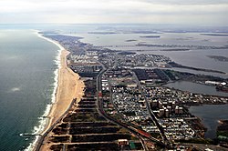
Aerial view of Edgemere, looking west.
Edgemere, Queens
Location within New York City
Coordinates: 40°35′42″N73°46′30″W / 40.595°N 73.775°W / 40.595; -73.775
Country Flag of the United States.svg  United States
State Flag of New York.svg  New York
City Flag of New York City.svg  New York City
County/Borough Flag of Queens County, New York.svg Queens
Community District Queens 14 [1]
Named for "Edge of the sea" [2]
Population
 (2019)
  Total18,100 [3]
Race and Ethnicity
  Non-Hispanic White7%
  Black or African-American56%
  Hispanic or Latino of any race32%
  Asian2%
  other3%
Economics
   Median income $32,785 [3]
Time zone UTC−5 (EST)
  Summer (DST) UTC−4 (EDT)
ZIP Code
11691
Area codes 718, 347, 929, and 917
Edgemere, looking towards Arverne View/Ocean Village Rockaway Beach Boulevard-Edgemere.jpg
Edgemere, looking towards Arverne View/Ocean Village
Edgemere, Queens Edgemere, Rockaway, NY.jpg
Edgemere, Queens

Edgemere is a neighborhood in the New York City borough of Queens, extending from Beach 32nd to Beach 52nd Street on the Rockaway Peninsula. It contains Rockaway Community Park. [4] Arverne is to the west, and Far Rockaway to the east. Edgemere was founded in 1892 by Frederick J. Lancaster, who originally called it New Venice. [5] [2]

Edgemere is located in Queens Community District 14 and its ZIP Code is 11691. [1] It is patrolled by the New York City Police Department's 101st Precinct.

Much like neighboring Arverne, Edgemere was developed as a beachfront tourist district with easy access to Brooklyn and Manhattan by railway. After World War II, the late 19th and early 20th century resorts and cheap bungalows that lined the boardwalk were considered outdated and undesirable by city officials. East of Beach 32nd Street, the original pattern of development can still be seen: rows of very small, single-story bungalows packed close together on narrow streets. As part of an urban renewal project, nearly all structures south of Rockaway Freeway, from Beach 32nd Street to Beach 90th Street, were acquired and demolished by 1970. Despite many ambitious plans for proposed development, no construction occurred until after 1984 and the coastline of Edgemere and Arverne remained lined with hundreds of acres of vacant wasteland for decades. [6] Arverne has since been redeveloped, but the coastal section of Edgemere remains entirely undeveloped. In April 2024, the vacant land became the 35-acre (14 ha) Taverne East Nature Preserve, a public park. [7] [8] In addition, as part of the Arverne East development, a welcome building for the nature preserve was built. [9]

Related Research Articles

<span class="mw-page-title-main">Rockaway, Queens</span> Neighborhoods in New York City

The Rockaway Peninsula, commonly referred to as The Rockaways or Rockaway, is a peninsula at the southern edge of the New York City borough of Queens on Long Island, New York. Relatively isolated from Manhattan and other more urban parts of the city, Rockaway became a popular summer retreat in the 1830s. It has since become a mixture of lower, middle, and upper-class neighborhoods. In the 2010s, it became one of the city's most quickly gentrifying areas.

<span class="mw-page-title-main">Broad Channel, Queens</span> Neighborhood in New York City

Broad Channel is a neighborhood in the southern portion of the New York City borough of Queens. It occupies the southern portion of Rulers Bar Hassock, the only inhabited island in Jamaica Bay.

<span class="mw-page-title-main">Far Rockaway, Queens</span> Neighborhood in New York City

Far Rockaway is a neighborhood on the eastern part of the Rockaway peninsula in the New York City borough of Queens. It is the easternmost section of the Rockaways. The neighborhood extends from Beach 32nd Street east to the Nassau County line. Its southern boundary is the Atlantic Ocean; it is one of the neighborhoods along Rockaway Beach.

<span class="mw-page-title-main">Rockaway Beach, Queens</span> Neighborhood of Queens in New York City

Rockaway Beach is a neighborhood on the Rockaway Peninsula in the New York City borough of Queens. The neighborhood is bounded by Arverne to the east and Rockaway Park to the west. It is named for the Rockaway Beach and Boardwalk, which is the largest urban beach in the United States, stretching from Beach 3rd to Beach 153rd Streets on the Atlantic Ocean. The neighborhood, with 13,000 residents as of 2010, is also known as the "Irish Riviera" because of its large Irish American population.

<span class="mw-page-title-main">Breezy Point, Queens</span> Neighborhood in New York City

Breezy Point is a neighborhood in the New York City borough of Queens, located on the western end of the Rockaway peninsula, between Rockaway Inlet and Jamaica Bay to the north and the Atlantic Ocean to the west and south. The community is run by the Breezy Point Cooperative, in which all residents pay the maintenance, security, and community-oriented costs involved with keeping the community private. The cooperative owns the entire 500-acre (2 km2) community; residents own their homes and hold shares in the cooperative.

Belle Harbor is a small residential neighborhood in the New York City borough of Queens, located on the western half of the Rockaway Peninsula, the southernmost area of the borough. Belle Harbor commonly refers to the area from Beach 126th to Beach 141st Streets.

<span class="mw-page-title-main">Springfield Gardens, Queens</span> Neighborhood in New York City

Springfield Gardens is a neighborhood in the southeastern area of the New York City borough of Queens, bounded to the north by St. Albans, to the east by Laurelton and Rosedale, to the south by John F. Kennedy International Airport, and to the west by Farmers Boulevard. The neighborhood is served by Queens Community Board 12. The area, particularly east of Springfield Boulevard, is sometimes also referred to as Brookville.

<span class="mw-page-title-main">Arverne, Queens</span> Neighborhood in New York City

Arverne is a neighborhood in the New York City borough of Queens, on the Rockaway Peninsula. It was initially developed by Remington Vernam, whose signature "R. Vernam" inspired the name of the neighborhood. Arverne extends from Beach 54th Street to Beach 79th Street, along its main thoroughfare Beach Channel Drive, alternatively known as Rev. Joseph H. May Drive.

<span class="mw-page-title-main">Beach 67th Street station</span> New York City Subway station in Queens

The Beach 67th Street station is a station on the IND Rockaway Line of the New York City Subway. Located at Beach 67th Street and Rockaway Freeway in Arverne, Queens, it is served by the A train at all times. The station is adjacent to Kohlreiter Square, a public green space on the north side of the station.

<span class="mw-page-title-main">Rockaway Park, Queens</span> Neighborhood in New York City

Rockaway Park is a neighborhood in the New York City borough of Queens. The area is on the Rockaway Peninsula, nestled between Jamaica Bay to the north and the Atlantic Ocean to the south. The neighborhood of Rockaway Beach lies on its eastern border while the community of Belle Harbor is situated on its western side. The neighborhood is part of Queens Community Board 14.

<span class="mw-page-title-main">Hammels, Queens</span>

Hammels is an area within Rockaway Beach on the Rockaway Peninsula in the New York City borough of Queens. It is located west of Arverne and east of Seaside, and is centered on Beach 84th Street. Its main thoroughfare is Beach Channel Drive. The New York City Subway's A train travels through the neighborhood on the IND Rockaway Line. The Hammel Houses, a public housing project built in 1955, is located in the neighborhood.

Frederick J. Lancaster was a land developer who in the 1890s, with a group of investors, founded the community of Edgemere, on the Rockaway Peninsula in Queens County. Originally the investors planned to call the community "New Venice" and develop it with canals and gondoliers. Although this venture failed, in 1894 Lancaster formed the Lancaster Sea Beach Improvement Company to build a more conventional seaside colony named "Edgemere". Lancaster built a large, luxurious hotel, the Edgemere, which opened in 1895 and became the major summer attraction in the community.

<span class="mw-page-title-main">Seaside, Queens</span> Neighborhood of Queens in New York City

Seaside is a section of the Rockaway Peninsula in the New York City borough of Queens. It is bordered by the Rockaway Beach neighborhood on the east, and by the neighborhood of Rockaway Park on the west. Formerly a resort community of small seasonal bungalows, Seaside is today dominated by middle-income high-rise Mitchell-Lama apartment buildings along its south shore beachfront. The zip code of Seaside is 11694.

<span class="mw-page-title-main">Rockaway Beach Boulevard</span> Boulevard in Queens, New York

Rockaway Beach Boulevard, opened in 1886, was the first major east-west thoroughfare on the Rockaway Peninsula in the Borough of Queens in New York City. Much of its route parallels the Rockaway Freeway and the IND Rockaway Line above the Freeway. The boulevard first forks off at its eastern end from Beach Channel Drive at Beach 35th Street in Edgemere and merges once again with Beach Channel Drive by Jacob Riis Park shortly before the Marine Parkway–Gil Hodges Memorial Bridge.

The Queens Community Board 14 is a local government in the New York City borough of Queens, encompassing the neighborhoods of Breezy Point, Belle Harbor, Neponsit, Arverne, Bayswater, Edgemere, Rockaway Park, Rockaway and Far Rockaway. It is bounded to the north by Brooklyn and Jamaica Bay, on the east by the Nassau County border, and to the south by the Atlantic Ocean.

<span class="mw-page-title-main">Woodhaven and Cross Bay Boulevards buses</span> Bus routes in Queens, New York

The Q11, Q21, Q52, and Q53 bus routes constitute a public transit corridor running along Woodhaven and Cross Bay Boulevards in Queens, New York City. The corridor extends primarily along the length of the two boulevards through "mainland" Queens, a distance of 6 miles (9.7 km) between Elmhurst and the Jamaica Bay shore in Howard Beach. The Q52 and Q53 buses, which provide Select Bus Service along the corridor, continue south across Jamaica Bay to the Rockaway peninsula, one of the few public transit options between the peninsula and the rest of the city.

<span class="mw-page-title-main">Kohlreiter Square</span> Green space in Queens, New York

Kohlreiter Square is an 8.6-acre public green space located in the Arverne neighborhood on Rockaway Peninsula in Queens, New York. It located along the north side of Rockaway Freeway between Beach 67th and Beach 69th Streets. The park honors two generations of civic activists, Nathan A. Kohlreiter (1880–1961) and his son Fred Kohlreiter (1913–1990) who contributed to the political and social fabric of the neighborhood.

<span class="mw-page-title-main">Edgemere Landfill</span> Former landfill in Queens, New York

Edgemere Landfill is a former municipal landfill located in Edgemere on the Rockaway peninsula in Queens, New York City. It is located on a man-made peninsula on the Jamaica Bay shoreline, at the eastern end of the Rockaway peninsula. A portion of the site is open to the public as Rockaway Community Park. The entire site is owned by the New York City Department of Parks and Recreation.

<span class="mw-page-title-main">Rockaway Beach and Boardwalk</span> Public park in Queens, New York

The Rockaway Beach and Boardwalk is a public park in Rockaway, Queens, New York, composed of the 170-acre (69 ha) Rockaway Beach and the adjacent 5.5-mile (8.9 km) Rockaway Boardwalk. The beach runs from Beach 9th Street in Far Rockaway to Beach 149th Street in Neponsit, a distance of 7 miles (11 km). The boardwalk, a concrete deck, runs from Beach 9th Street to Beach 126th Street in Rockaway Park, at the edge of Belle Harbor. There are also numerous recreational facilities within the park, parallel to the beach and boardwalk.

References

  1. 1 2 "NYC Planning | Community Profiles". communityprofiles.planning.nyc.gov. New York City Department of City Planning. Retrieved April 7, 2018.
  2. 1 2 Jackson, Kenneth T., ed. (2010). The Encyclopedia of New York City (2nd ed.). New Haven: Yale University Press. p. 1913. ISBN   978-0-300-11465-2.
  3. 1 2 "Edgemere, Queens" (PDF). New York City Office of Environmental Remediation. Retrieved June 6, 2021.
  4. Rockaway Community Park NYC Parks
  5. The Rockaways. Accessed October 2, 2007. "Edgemere was developed by Frederick J. Lancaster in 1892. The area was a sandy waste, with only two or three houses and the Half-Way House. Mr. Lancaster called the place New Venice."
  6. "Ărverne Housing Beset By Delays". The New York Times. December 20, 1970. ISSN   0362-4331 . Retrieved August 29, 2023.
  7. Parry, Bill (April 26, 2024). "City opens new 35-acre public nature preserve along the Rockaway waterfront in Edgemere". QNS. Retrieved July 2, 2024.
  8. Rahmanan, Anna (April 26, 2024). "Take a look at this new nature preserve by the Rockaway waterfront". Time Out New York. Retrieved July 2, 2024.
  9. Schulman, Pansy (March 22, 2024). "WXY Designs a 'Public Beach House' for The Rockaways". Architectural Record. Retrieved July 2, 2024.