South Jamaica (also commonly known as "Southside") is a residential neighborhood in the New York City borough of Queens. It is located south of downtown Jamaica. Although a proper border has not been established, the neighborhood is a subsection of greater Jamaica bounded by the Long Island Rail RoadMain Line tracks, Jamaica Avenue, or Liberty Avenue to the north; the Van Wyck Expressway on the west; Rockaway Boulevard on the south; and Merrick Boulevard on the east, adjoining the neighboring community of St. Albans.[4] Other primary thoroughfares of South Jamaica include Baisley, Foch, Linden, Guy R. Brewer, and Sutphin Boulevards.[5] The 180th Street Business Improvement District is responsible for the development of the area.
South Jamaica is often referred to as "Southside" or "Southside Jamaica" (also spelled as "South Side").[5][13][25][26][27] This is said to be derived from the location of the neighborhood and its demographics; Hollis, Queens in the northeast corner of greater Jamaica and Queens CB12 is referred to as "Northside".[5] The South Side nickname dates back to the first half of the 20th century, when several local community organizations carried the name.[28][29][30] An additional nickname, "South Suicide Queens", is a reference to the high crime rate in the neighborhood since the 1980s.[27]
History
Etymology
South Jamaica is named for its location south of Jamaica; the name Jamaica itself is derived from the Lenape word Yameco meaning "beaver".[31] This was reflected in the naming of Beaver Pond at the border of Jamaica and South Jamaica.[32] Through the 20th century, the neighborhood was also known as Cedar Manor.[33][34]
17th century to 1930s
Through the 19th century, what is now South Jamaica consisted of farmland.[4][31] Early developments in South Jamaica included the Prospect Cemetery opened in 1668, and the Prospect and St. Monica's Churches opened around 1857.[4][13][32]Baisley Pond, created by local farmers from dammed streams, was acquired by the City of Brooklyn's Williamsburg Water Works Company in 1852 for municipal water supplies.[4][19][35]
The Jamaica Race Course was opened in 1894 at Baisley Boulevard and New York Avenue (today's Guy R. Brewer Bouelvard), and expanded in the early 1900s. Some sources state its official opening year as 1903.[4][6][31][33][36] Transportation was introduced into the neighborhood at the turn of the century. The Far Rockaway Line streetcar was opened along New York Avenue between downtown Jamaica and the Jamaica Racetrack on September 1, 1896, and was extended to the Rockaways by summer 1897.[33] The Cedar Manor station opened at Linden Boulevard along the LIRR Atlantic Branch in 1906.[34][37] The Queens Boulevard Line streetcar to Midtown Manhattan was extended along Sutphin Boulevard to 109th Avenue in South Jamaica in April 1916.[38][39]Baisley Pond Park was opened by the city in 1919.[18][19]
In the 1920s, the neighborhood's population exploded after streets were laid down and houses constructed.[4][19][31][33] Many African Americans began moving into the neighborhood at this time, while White residents began leaving the neighborhood, coinciding with other white flight periods in the city. By the 1930s, the neighborhood was considered to be predominantly Black, especially in contrast to other southeast Queens neighborhoods, although a significant White population remained.[6][14][40][41] At this time, the neighborhood was considered a major slum, due to overcrowding, high crime, and lack of infrastructure. Many houses were frame houses constructed only of wood and were not fireproof, while residences in the neighborhood were without modern utilities such as electricity and indoor plumbing.[6][7][14][40][42][43] The Jamaica Racetrack, meanwhile, was blamed for bringing down property values,[6] and was in poor operating condition.[44]
Urban renewal
In 1939, the city began slum clearance projects in the neighborhood. The first was the South Jamaica Houses public housing project, originally referred to as the "'South Jamaica' slum clearance project", opened in July 1940.[4][6][14][40][42][45][46] A second portion of the project opened in 1954.[4][14] By 1955, following the takeover of the Jamaica Race Course by the Greater New York Association,[6][47] the city and city planner Robert Moses began evaluating plans to replace the track with new development. Plans included an additional public housing development, and one of several potential Queens sites for the failed relocation of the Brooklyn Dodgers.[6][48] In October 1956, Moses planned a middle-income cooperative to be constructed on the site.[6][44][49] The track was closed in 1959 and demolished in 1960, replaced by an expanded Aqueduct Racetrack.[4][6][48][50][51]
In 1959, the LIRR Atlantic Branch was grade-separated, leading to the closure of the Cedar Manor station.[37] The Baisley Park Houses were opened in 1961. Rochdale Village opened in December 1963 on the former Jamaica Racetrack site, bringing with it the neighborhood's first supermarkets and shopping centers.[4][6][44][48] The Cedar Manor Co-op opened around this time as well.[31][52] By this time, the neighborhood was overwhelmingly Black, with the exception of the racially integrated Rochdale Village.[6][44][53][54] In 1970, the New York City Board of Higher Education approved plans to replace 50 acres (20ha) of slum land with a permanent campus for York College. The site included the Prospect Cemetery and the Prospect and St. Monica's Churches.[55][56] At the same time, under the Program for Action the Metropolitan Transportation Authority planned to extend subway service into the neighborhood, by connecting the LIRR Atlantic Branch with the planned Archer Avenue subway in downtown Jamaica via a ramp in or near the campus site.[55][56] The subway connection was never constructed, due to funding issues caused by the city's fiscal crisis.[57][58] The York College campus, also delayed by the fiscal crisis, began construction in 1980 and opened in stages beginning in 1988.[59]
1970s to 1990s
Despite urban renewal efforts, in 1966 South Jamaica was designated an official poverty zone by the administration of President Lyndon B. Johnson during the president's war on poverty,[44] and was considered one of the few remaining slums in the otherwise middle-class borough of Queens.[54] In the late 1960s and continuing through the 1970s, South Jamaica and other Southeast Queens neighborhoods saw increasing rates of drug sales and usage, including cocaine and heroin epidemics.[5][6][44][60] The neighborhood also had some of the highest rates of automobile theft in the city, attributed to the proximity to car theft rings centered in John F. Kennedy International Airport.[44][61] In 1972, South Jamaica was declared "the largest officially designated poverty area in Queens" by the Human Resources Administration.[53]
The neighborhood was also the center of several racial issues in the 1970s. Students from South Jamaica were bused into other school districts in order to maintain integration of schools, leading to outcry from White residents of those districts.[62][63] Other racial events included the shooting of Clifford Glover on April 28, 1973 by a plainclothes NYPD officer.[64][65][66][67] The acquittal of the officer and his partner[65][66][68] led to incidents of looting, rioting, and incidents of violence against Whites in South Jamaica and Downtown Jamaica.[66][69]
In the 1980s and 1990s, South Jamaica was one of several New York City neighborhoods victimized by the national crack cocaine epidemic. Several gangs operated in the neighborhood. The Corley gang operated out of the South Jamaica Houses. The Supreme Team, formed in 1981 by Kenneth "Supreme" McGriff, operated out of the Baisley Park Houses. The cartel of Lorenzo "Fat Cat" Nichols was also headquartered in the neighborhood, supplying much of the cocaine in the area and around Queens. These groups had originated from the Seven Crowns gang that was started during the cocaine and heroin epidemic in the 1970s, and which expanded into a multi-state operation by the 1980s. Increases in murder rates and other crime followed the spike in drug-related activity.[5][18][23][25][26][31][70] In 1986, the 113th and 103rd police precincts led Queens in murder incidents, with the 113th precinct ranking tenth in the city.[22][71][72] On February 26, 1988, rookie police officer Edward Byrne was killed while guarding the house of a witness in a drug-related trial.[23][25][73][74] Byrne's murder, and other violent crime in the neighborhood led South Jamaica to become a symbol for the national drug epidemic, and the city's war on drugs instigated by Mayor Ed Koch.[23][31][74] Following the killing, Koch created the Tactical Narcotics Team (TNT) program, with the first team dispatched to South Jamaica on March 14, 1988.[23][25][75][76]
2000s
Entering the 21st century, South Jamaica has seen a revival in terms of safety and quality of life.[13][18][31] While crime is still higher than other Queens areas, the NYPD 113th Precinct (which also patrols Hollis, St. Albans and Springfield Gardens) saw dramatic decreases in violent crime since the 1990s, with a drop in major crime of 76 percent between 1993 and 2010.[24][31][77]
Demographics
Based on data from the 2020 United States Census, the population of South Jamaica was 270,688, an increase of 231,794 from the 38,894 counted in 2010. Covering an area of 918.87 acres (371.85ha), the neighborhood had a population density of 42.3 inhabitants per acre (27,100/sqmi; 10,500/km2).[2]
The area is largely a middle-class community consisting of suburban one- and two-family houses ranging from colonials built around the 1960s to new developments.[4][13][18]
A small section of South Jamaica is named Bricktown, for its many brick row houses.[78]
South Jamaica and St. Albans are patrolled by the NYPD's 113th Precinct, located at 167-02 Baisley Boulevard.[8] The 113th Precinct ranked 55th safest out of 69 patrol areas for per-capita crime in 2010.[79] The 113th Precinct also has a lower crime rate than in the 1990s, with crimes across all categories having decreased by 86.1% between 1990 and 2018. The precinct reported 5 murders, 28 rapes, 156 robberies, 383 felony assaults, 153 burglaries, 414 grand larcenies, and 138 grand larcenies auto in 2018.[80]
Post offices and ZIP Codes
South Jamaica is covered by multiple ZIP Codes. West of Sutphin Boulevard, South Jamaica falls under ZIP Codes 11435 north of Linden Boulevard and 11436 south of Linden Boulevard. East of Sutphin Boulevard, South Jamaica is part of two ZIP Codes: 11433 north of Linden Boulevard and 11434 south of Linden Boulevard.[81] The United States Post Office operates the Rochdale Village Station post office at 165-100 Baisley Boulevard.[82]
Education
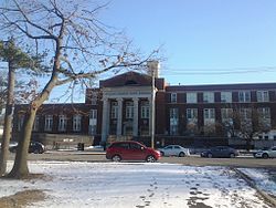
Eagle Academy for Young Men III at Merrick and Linden Boulevards.
Public and charter schools
Several elementary schools are located in South Jamaica:
Samuel Huntington School (P.S. 40), on 109th Avenue and Union Hall Street near the South Jamaica Houses.[16][17][70]
Walter Francis Bishop School (P.S. 160), on Inwood Street off of Sutphin Boulevard.[16][14]
P.S. 123, on 119th Avenue between Inwood Street and 145th Street, just south of Foch Boulevard.[16]
Edward K. Ellington School (P.S. 140), on 116th Avenue east of Brewer Boulevard; named after Duke Ellington.[16][14]
Ruby S. Couche Elementary School (P.S. 30) and P.S. 354, on Baisley Boulevard and Bedell Street in Rochdale Village.[16]
Lyndon B. Johnson School (P.S. 223), on Sutphin Boulevard just north of Rockaway Boulevard adjacent to the Baisley Park Garden development; named after U.S. President Lyndon B. Johnson.[16][18]
Clarence Witherspoon School (P.S. 45), on Rockaway Boulevard and 150th Street across from Baisley Pond Park and Baisley Park Garden.[16]
Talfourd Lawn Elementary School (P.S. 50), on 101st Avenue and Allendale Street one block north of Liberty Avenue, and just west of the Van Wyck Expressway.[16][14]
Thurgood Marshall Magnet School (P.S. 80), on 137th Avenue in Rochdale Village; named after Thurgood Marshall.[16]
Rochdale Early Advantage Charter School, on Baisley Boulevard and 165th Street across from Rochdale Village.[16]
Middle and junior high schools include:
Junior High School 40, adjacent to P.S. 40.[14][84]
Richard Grossley Junior High School (J.H.S. 8), just off of Merrick Boulevard between 108th and 109th Avenues.[16][17]
Eagle Academy for Young Men of Southeast Queens (Eagle Academy III), a middle and high school located at Merrick and Linden Boulevards.[16][85]
Catherine and Count Basie School (M.S. 72; formerly J.H.S. 72), on Brewer Boulevard in Rochdale Village.[16]
York Early College Academy, a middle and high school in the M.S. 72 building on Brewer Boulevard in Rochdale Village.[16][85]
The High School for Law Enforcement and Public Safety, on Brewer Boulevard and 116th Avenue just north of Foch Boulevard, adjacent to the Baisley Park Houses.[16][17][85]
Queens Transitional Center or Queens Transition Center (former J.H.S. 142/I.S. 142), a special education school at Linden Boulevard and 142nd Street (142-10 Linden Boulevard).[16][14][85][88][89] The facility also houses a branch of The School of Cooperative and Technical Education (Coop Tech),[90] and the Jamaica campus of Queens Academy High School.[91]
Higher education
The campus of CUNYYork College is located at the north end of South Jamaica, between the LIRR Main Line to the north and South Road to the south, across from the South Jamaica Houses.[16][4][17]
↑Glaysher, Scott. "Lloyd Banks Proves His Worth on All or Nothing: Live It Up", XXL, October 4, 2016. Accessed June 22, 2017. "The music is so deeply New York that it wouldn’t come as a surprise if Banks was recording every song while tucked away in a small home studio in the deepest and darkest corner of South Jamaica, Queens.... In fact, the first line of the entire tape is “South Jamaica, baby, they made me to be the greatest,” which is ultimately the general thesis of the tape itself."
↑Williams, Lena. "Track And Field; Soothing an Old Ache", The New York Times, January 1, 2000. Retrieved November 7, 2007. "Neither the outpouring of affection from an adoring public nor the love he finally found after four failed marriages could make up for the neglect and physical abuse he suffered as a child growing up in South Jamaica, Queens."
↑"In The Mail", The Fader, October 10, 2006. Accessed November 30, 2023. "Teaser single 'Come Get It' is extremely catchy, but b-side 'Queens' is a revelation; over elegiac horns and a slow rolling drumline, Yummy pens a winding, unexpected melody as tribute to a rough childhood. 'South Jamaica, can’t find no place greater…ain’t nothing pretty, but I find so much beauty in my streets,' she sings."
↑Madden, Sidney. "Happy Birthday, Grafh!", XXL, August 22, 2016. Accessed March 5, 2023. "Today, Aug. 22, is the birthday of Queens rapper Grafh. The MC is now 36. Born Philip Bernard, the South Jamaica Queens rapper is an admired MC with nearly 20 years in the business."
↑Jackson, Joshua. "Milford Graves, Visionary Drummer Who Mapped The Music Of The Heart, Dead At 79", NPR, February 16, 2021. Accessed March 5, 2023. "Milford Robert Graves was born in Queens, N.Y. on Aug. 20, 1941. His father, a chauffeur and his mother raised Milford in the South Jamaica Houses, known as The Forty, some of the first housing projects built and operated by the New York City Housing Authority."
↑Hall, David. "Our Greatest Hits: Norfolk State’s Robert Jones arrived as a men’s basketball coach the hard way", The Virginian-Pilot, June 23, 2020. Accessed March 5, 2023. "Jones, who was promoted to replace Anthony Evans on April 15 after six years as Evans' assistant at NSU, came to Division I head coaching the hard way. His gradual rise from below the high school varsity ranks was replete with long drives, ridiculous hours, laughable pay, plenty of second-guessing and a near career change. And that came after a destitute childhood spent, in part, in the brutal projects of South Jamaica, Queens, in New York, where his mother always found a way to take care of him."
↑Acevedo, Angelica. "Amateur fencer making strides at St. John’s", Queens Courier, October 15, 2017. Accessed June 23, 2023. "A native of South Jamaica, Curtis McDowald is not too far away from home as he begins his senior year at St. John’s University and his third consecutive year on its fencing team, in the epee category."
↑Stutz, Colin. "Nicki Minaj Receives Key to Queens, New York", Billboard, June 26, 2017. Accessed March 5, 2023. "Nicki Minaj was honored with the key to the city of her hometown, Queens, New York, on Monday. Minaj was born in Port of Spain, Trinidad and Tobago, but raised in South Jamaica, Queens, when she was 5."
↑Eustice, Kyle. "Pharoahe Monch - The HipHopGods Interview", The Coli, May 12, 2014. Accessed June 22, 2017. "Born Troy Donald Jamerson in the South Jamaica, Queens area of New York City in 1972, Pharoahe Monch witnessed hip-hop as it was just beginning to breathe new life in the '70s and '80s."
↑"Kyle O’Quinn’S Hard Work Off The Court Paying Off", MSG Network, January 29, 2018. Accessed June 23, 2023. "O’Quinn knew it was time to go back to the basics, time to do the things that made the kid from South Jamaica, Queens and Norfolk State an NBA dream come true story."
↑Berman, Ron. "Queens’ Artest set to represent Lakers in NBA Finals", New York Post, June 3, 2010. Accessed March 5, 2023. "Even with Knicks fans’ minds on LeBron James, there is a good local story at The Finals with Artest and South Jamaica’s Lamar Odom, two Queens guys who’ve played together since they were 12 years old on BQE Express going for a ring in Tinseltown."
↑Espinoza, Joshua. "Here’s How to Watch Cypress Hill and Onyx in Verzuz’s ‘Fight Night Music’ Battle", Complex Networks, May 14, 2022. Accessed March 5, 2022. "Onyx was founded more than 30 years ago in South Jamaica, Queens, by Fredro Starr, Sonny Seeza, and Big DS, who died in 2003 after a battle with lymphatic cancer. Sticky Fingaz joined the group in 1991 and remains an active Onyx member alongside Fredro."
This page is based on this Wikipedia article Text is available under the CC BY-SA 4.0 license; additional terms may apply. Images, videos and audio are available under their respective licenses.