169th Street station (IND Queens Boulevard Line)

Last updated

 169 Street
  NYCS-bull-trans-F-Std.svg NYCS-bull-trans-Fd-Std.svg
MTA NYC logo.svg New York City Subway station (rapid transit)
IND Queens Boulevard 169th Street Northbound Platform.jpg
Northbound platform
Station statistics
Address169th Street & Hillside Avenue
Queens, NY 11432
Borough Queens
Locale Jamaica
Coordinates 40°42′38″N73°47′35″W / 40.710638°N 73.793063°W / 40.710638; -73.793063
Division B (IND) [1]
Line IND Queens Boulevard Line
Services    F   NYCS-SSI-alltimes.svg (all times) <F> NYCS-SSI-rushpeak.svg  (two rush hour trains, peak direction)
Transit
StructureUnderground
Tracks4
Other information
OpenedApril 24, 1937(87 years ago) (1937-04-24) [2] [3]
Opposite-
direction
transfer
Yes
Traffic
20231,627,817 [4] Increase2.svg 6.8%
Rank190 out of 423 [4]
Services
Preceding station MTA NYC logo.svg New York City Subway Following station
Parsons Boulevard
F   NYCS-SSI-alltimes.svg <F> NYCS-SSI-rushpeak.svg
NYCS-bull-trans-F-Std.svg NYCS-bull-trans-Fd-Std.svg
Local
Jamaica–179th Street
F   NYCS-SSI-alltimes.svg <F> NYCS-SSI-rushpeak.svg
Terminus
Location
NYCS map blank.svg
Map pointer.svg
USA New York City location map.svg
Map pointer.svg
USA New York location map.svg
Map pointer.svg
Track layout

Contents

BSicon numN285.svg
BSicon MFADEg.svg
BSicon uvSTR.svg
BSicon MFADEg.svg
BSicon uvSTR.svg
BSicon uvSTRf.svg
BSicon uvSTRg.svg
BSicon udSTR.svg
BSicon uvUSTr.svg
BSicon udSTR.svg
BSicon uvUST.svg
BSicon uvUST.svg
BSicon dPLTl.svg
BSicon uvSTR.svg
BSicon uvSTR.svg
BSicon dPLTr.svg
BSicon dPLTl.svg
BSicon uvSTR.svg
BSicon uvSTR.svg
BSicon dPLTr.svg
BSicon dPLTl.svg
BSicon uvSTR.svg
BSicon uvSTR.svg
BSicon dPLTr.svg
BSicon dPLTl.svg
BSicon uvSTR.svg
BSicon uvSTR.svg
BSicon dPLTr.svg
BSicon uvSTRf.svg
BSicon uvSTRg.svg
BSicon MFADEf.svg
BSicon uvSTR.svg
BSicon MFADEf.svg
BSicon uvSTR.svg
Street map

169th Street station (IND Queens Boulevard Line)

Station service legend
SymbolDescription
NYCS-SSI-alltimes.svg Stops all times
NYCS-SSI-rushpeak.svg Stops rush hours in the peak direction only (limited service)

The 169th Street station is a local station on the IND Queens Boulevard Line of the New York City Subway. Located at the intersection of 169th Street and Hillside Avenue in Queens, it is served by the F train at all times, the <F> train during rush hours in the reverse peak direction, and a few rush-hour E trains to Jamaica–179th Street during p.m. rush hours. [5]

169th Street station opened on April 24, 1937, as the terminal station of the Independent Subway System's Queens Boulevard Line. This station was once heavily used because of the many bus connections available for riders heading further east within Queens. It became the closest subway station to the 165th Street Bus Terminal after the closure and demolition of the nearby 168th Street BMT station on Jamaica Avenue in 1977. Ridership at 169th Street station declined significantly following the opening of the Archer Avenue lines in 1988.

History

Construction

The Queens Boulevard Line was one of the first built by the city-owned Independent Subway System (IND), and was planned to stretch between the IND Eighth Avenue Line in Manhattan and 178th Street and Hillside Avenue in Jamaica, Queens. [6] [7] The line was first proposed in 1925. [8] Construction of the line was approved by the New York City Board of Estimate on October 4, 1928. [9] On December 23, 1930, the contract for the construction of the section between 137th Street (now the Van Wyck Expressway) and 178th Street—Route 108, Section 11—was let. This section included the stations at 169th Street, Parsons Boulevard, Sutphin Boulevard, and Briarwood. [10] As planned, Parsons Boulevard was to be an express stop, while the other three stations, including 169th Street, would be local stops. [11] The contract for this section was awarded to Triest Contracting Corporation. [12] The line was constructed using the cut-and-cover tunneling method, and to allow pedestrians to cross, temporary bridges were built over the trenches. [13]

The first section of the line opened on August 19, 1933 from the connection to the Eighth Avenue Line at 50th Street to Roosevelt Avenue in Jackson Heights. [14] Later that year, a $23 million loan was approved to finance the remainder of the line, along with other IND lines. [15] The remainder of the line was built by the Public Works Administration. [16] In summer 1933 work on this station and 169th Street were completed, far ahead of schedule. [12] In 1934 and 1935, construction of the extension to Jamaica was suspended for 15 months and was halted by strikes. [17] Construction was further delayed due to a strike in 1935, instigated by electricians opposing wages paid by the General Railway Signal Company. [18]

In April 1936, William Jerome Daly, the secretary of the New York City Board of Transportation, stated, in response to requests for a stop at 178th Street, that constructing a station at that location would prevent express service from operating past 71st Avenue. He said that with a final station at 169th Street, express trains could run to Parsons Boulevard, and that if the line was extended to Springfield Boulevard as planned, express service could be extended past 178th Street with a yard east of the new terminal. [19]

In August 1936, construction to Forest Hills was expected to be completed by the end of the year. While the tracks were installed all the way to 178th Street, the stops to the east of Union Turnpike still needed to be tiled, have stairways, turnstiles and lighting installed. Two additional contracts remained to be put up for bid, both the results of last minute changes. One of the changes concerned the line's eastern terminal. Initially, express trains were planned to terminate at a station at 178th Street. However, the plans were changed to terminate the express trains at Parsons Boulevard, requiring the installation of switches. Since construction of the tunnel was already completed in this section, a few hundred feet of the wall separating the eastbound and westbound train tracks had to be removed to fit the two switches. [20] In addition, a new tunnel roof and new side supports had to be constructed. [21] Since the line's new terminal would be at 169th Street, the tracks at 178th Street would be used to turn back trains. This change delayed the opening of the line from Union Turnpike to 169th Street, [21] and also led to protests from the Jamaica Estates Association because the 178th Street station had been eliminated. [20]

A 3.5-mile (5.6 km) extension from Roosevelt Avenue to Kew Gardens opened on December 31, 1936. [22] In March 1937, the extension to 169th Street was expected to be opened on May 1, requiring work to be finished by April 3, and fully approved and tested by April 20. As of this point, minor station work remained, including the installation of light bulbs, with the only major work left to be completed being the final 200 feet (61 m) of track in the 169th Street terminal. [21]

Opening

On April 9, 1937, Mayor Fiorello La Guardia announced that the operation of the $14.4 million extension to Jamaica and express service would begin on April 24. [2] [23] The extension to Hillside Avenue and 178th Street, with a terminal station at 169th Street, opened as planned on April 24, 1937. [24] [25] [26] Service was initially provided by E trains, which began making express stops from 71st–Continental Avenues to Queens Plaza during rush hours on the same date, and by EE local trains during non-rush hours. The express service operated between approximately 6:30 and 10:30 a.m. and from 3:00 p.m. to 7:00 p.m., [16] [27] and ran every three to five minutes. [28] This extension was celebrated with a ribbon-cutting ceremony at the Parsons Boulevard station and with a parade along Hillside Avenue. [29]

Mosaic name tablet and Queens Public Library sign 169th Street - IND Queens Blvd; QBPL sign over Mosaic.jpg
Mosaic name tablet and Queens Public Library sign

On December 15, 1940, F trains began running via the newly opened IND Sixth Avenue Line, also running express west of 71st Avenue. 169th Street and Parsons Boulevard were both used as terminal stations during this time, with the E terminating at this station and the F at Parsons Boulevard. [30] This setup was instituted to prevent congestion at both stations. [31] :123

While 169th Street was the end of the line, F trains terminated at Parsons Boulevard because the 169th Street station provided an unsatisfactory terminal setup for a four-track line. There were no storage facilities provided at the 169th Street station, and since 169th Street was a local station, trains on the outer local tracks had to cross over to the inner express tracks to reverse direction. Therefore, the line was planned to be extended to 184th Place with a station at 179th Street containing two island platforms, sufficient entrances and exits, and storage for four ten-car trains. The facilities would allow for the operation of express and local service to the station. [31] Delayed due to the Great Depression and World War II, the extension was completed later than expected and opened on December 11, 1950. [32] [33] E trains were extended there at all times and F trains were extended evenings, nights, and Sunday mornings. [34] On May 13, 1951, all F trains outside of rush hour were extended to 179th Street using the local tracks beyond Parsons Boulevard. On October 8, 1951, trains were extended to 179th Street at all times. [35] During rush hours F trains skipped 169th Street running via the express tracks. At other times, the F stopped at 169th Street. [36]

In 1953, the platforms at several IND stations were lengthened to allow eleven-car trains; originally, service was provided with ten-car trains. [lower-alpha 1] [38] The lengthened trains began running during rush hour on September 8, 1953. Eleven-car trains would only operate on weekdays. [39] :37–38 The extra car increased the total carrying capacity by 4,000 passengers. [38] The operation of eleven-car trains ended in 1958 because of operational difficulties. The signal blocks, especially in Manhattan, were too short to accommodate the longer trains, and the motormen had a very small margin of error to properly platform the train. It was found that operating ten-car trains allowed for two additional trains per hour to be scheduled. [40]

Archer Avenue extension

Before the IND Archer Avenue Line opened on December 11, 1988, all Queens Boulevard express trains (E and F trains) ran to 179th Street, with the E running express along Hillside Avenue during rush hours only and the F running local. [41] At that time, the 169th Street station was considered to be the most congested due to the numerous bus lines that either terminated just outside or at the nearby 165th Street Bus Terminal; [42] this use had increased after the closure and demolition of the nearby 168th Street BMT station on Jamaica Avenue in 1977. [43] The station was ill-equipped to handle the high passenger traffic volume transferring between the buses and subway, and The New York Times stated that during peak hours, passengers had to wait just to get to the platform. [42] As a result, bars were installed on each of the seven 179th Street-bound staircases at platform level to "feed" passengers into the staircases and prevent them from crowding around it. [44]

The opening of the Archer Avenue Line was expected by the New York City Transit Authority to reduce rush hour ridership at this station from 12,912 to 6,058. The locations of the station's full-time and part-time booths were switched in 1988, since more than half of the remaining riders lived closer to the 169th Street entrance. Before the change, most riders came from the Bus Terminal via the 168th Street entrance. The formerly full-time 168th Street booth was made part-time, and the formerly part-time 169th Street booth was made full-time. [45] :12–13

Station layout

GroundStreet levelExit/entrance
MezzanineFare control, station agent, MetroCard machines
Platform level Side platform
Southbound local NYCS-bull-trans-F-Std.svg NYCS-bull-trans-Fd-Std.svg toward Coney Island–Stillwell Avenue (Parsons Boulevard)
Southbound express NYCS-bull-trans-E-Std.svg does not stop here (select rush hour trips)
Northbound express NYCS-bull-trans-E-Std.svg does not stop here (select rush hour trips) →
Northbound local NYCS-bull-trans-E-Std.svg toward Jamaica–179th Street (two p.m. rush hour trips) (Terminus)
NYCS-bull-trans-F-Std.svg NYCS-bull-trans-Fd-Std.svg toward Jamaica–179th Street (Terminus)
Side platform
The southwest entrance Hillside Av 169th St td (2018-08-02) 01 - IND.jpg
The southwest entrance

This underground station has four tracks and two side platforms. [46] [47] The F train stops here at all times. [48] The station is between Parsons Boulevard to the west and Jamaica179th Street to the east. [49] The center express tracks are used by the limited rush hour E service to Jamaica–179th Street. [47]

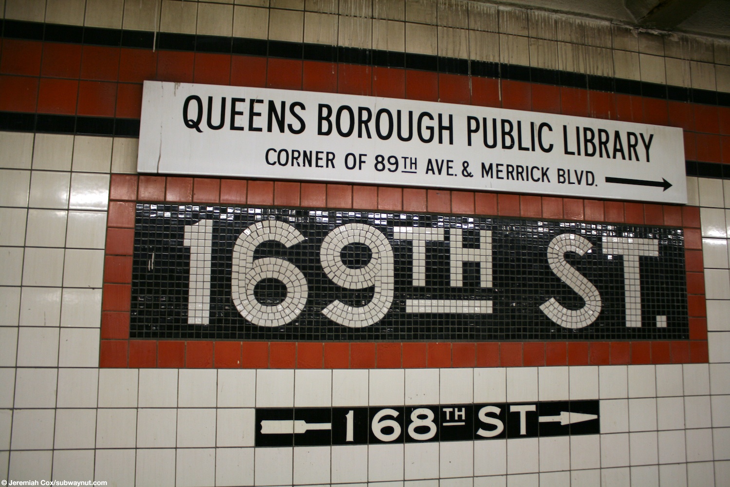
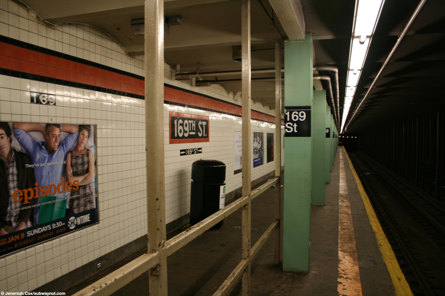
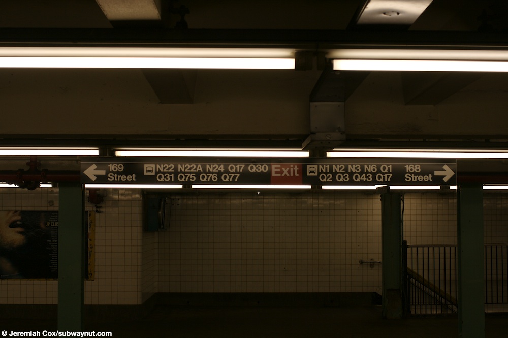
Both platforms have a vermilion trim line with a black border and mosaic name tablets reading "169TH ST." in white sans-serif lettering on a black background with vermilion border. Small "169" and directional tile captions in white lettering on a black background run below the trim line and name tablets. [50] The tile band is part of a color-coded tile system used throughout the IND. [51] The tile colors were designed to facilitate navigation for travelers going away from Lower Manhattan. As such, a different tile color is used at Jamaica–179th Street, the next express station to the east. The red tiles used at the 169th Street station were also used at Parsons Boulevard, the next express station to the west. [52] [53]

Lime green I-beams run along the platforms and mezzanine at regular intervals, alternating ones having the standard black station name plate with white lettering. [50] [54] [55] [56] The I-beam piers are located every 15 feet (4.6 m) and support girders above the platforms. The roof girders are also connected to columns in the walls adjoining each platform. [57] :3

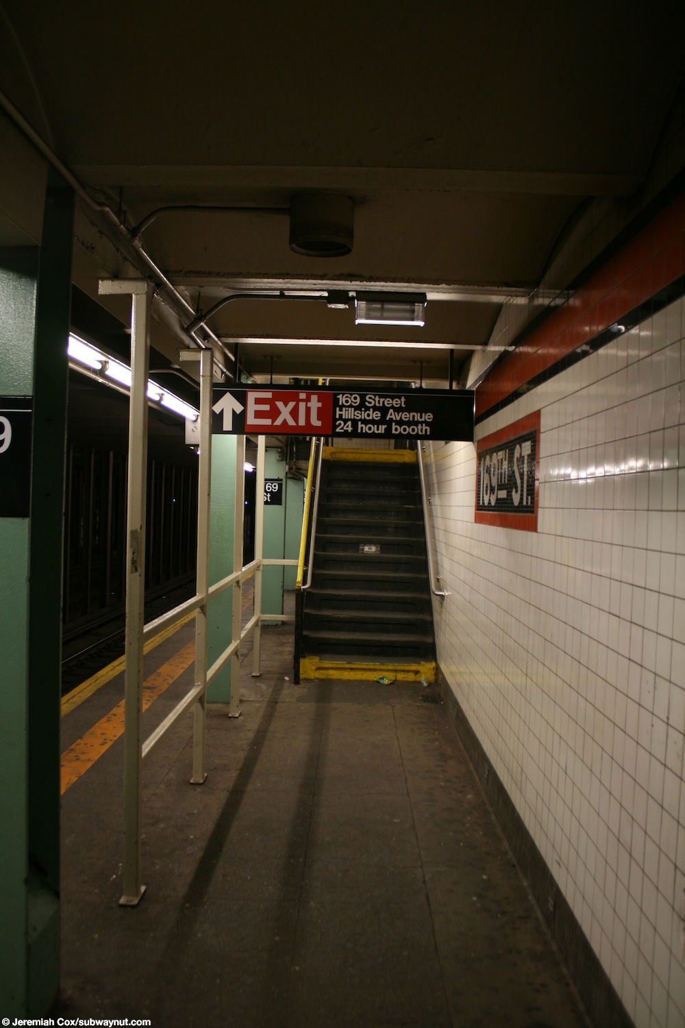
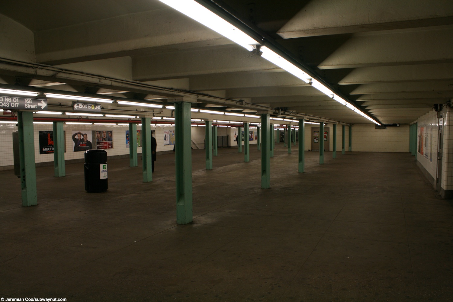
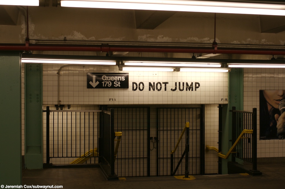
The station has a full-length mezzanine above the platforms with a crossover between both platforms. [46] [58] [59] [60] When the station opened, IND engineers had concluded that only a small portion of the mezzanine was needed, which led to a 1959 proposal to convert the mezzanine into an underground parking garage. [58] Despite this, the 169th Street station's mezzanines included turnstiles and change booths at both ends, in contrast to several other stations on the same line, which included turnstiles at only one end. [58] Above the Manhattan-bound platform, the mezzanine gets narrower as it makes way for employee space. [61] Due to low clearance, a "DO NOT JUMP" message in black letters is painted on the white tiles of the ceiling above one of the 179th Street-bound staircases. [62]

The tunnel is covered by a U-shaped trough that contains utility pipes and wires. The outer walls of this trough are composed of columns, spaced approximately every 5 feet (1.5 m) with concrete infill between them. There is a 1-inch (25 mm) gap between the tunnel wall and the platform wall, which is made of 4-inch (100 mm)-thick brick covered over by a tiled finish. The columns between the tracks are also spaced every 5 feet (1.5 m), with no infill. [57] :3

Exits

There are two fare control areas at either end of the mezzanine. The full-time entrances are at 169th Street, and stairs go up to all four corners of that intersection. [63] As of 2007, the 169th Street turnstile bank consists of six regular turnstiles, two High Entry-Exit Turnstiles, and two high exit-only turnstiles. [46] The 169th Street entrances have been the full-time entrances since 1988, when the Archer Avenue lines opened, dramatically reducing ridership at this station. [12] :12–13 The part-time entrances are at 168th Street, with stairs going up to all four corners; [63] this was the full-time entrance until 1988. [12] :12–13 The 168th Street turnstile bank also has six regular turnstiles, two HEETs, and two high exit-only turnstiles. [46] At both entrances, staircases go up to all four corners of the street's intersection with Hillside Avenue. [63] [58] When it was originally built, the station had staffed token booths at both fare control areas. [58] The 169th Street station is the closest to the 165th Street Bus Terminal, though the entrances at 168th Street are closer than those at 169th Street. [63]

Notes

  1. The platforms at 75th Avenue and Sutphin Boulevard on the Queens Boulevard Line were lengthened to allow 11-car operation on the E and F routes. The subway cars on the IND were built to be 60 feet (18.3 m) long. These cars typically operated in 10-car trains, with an entire train length being 600 feet (182.9 m). When platforms at stations were lengthened to accommodate 11-car trains, the platforms had to be extended an additional car length, or 60 feet (18.3 m), making the platform at least 660 feet (201.2 m) long. [37] :185

Related Research Articles

<span class="mw-page-title-main">E (New York City Subway service)</span> New York City Subway service

The E Queens Boulevard Express/
Eighth Avenue Local
is a rapid transit service in the B Division of the New York City Subway. Its route emblem, or "bullet", is blue since it uses the IND Eighth Avenue Line in Manhattan.

The IND Queens Boulevard Line, sometimes abbreviated as QBL, is a line of the B Division of the New York City Subway in Manhattan and Queens, New York City, United States. The line, which is underground throughout its entire route, contains 23 stations. The core section between 50th Street in Hell's Kitchen, Manhattan, and 169th Street in Jamaica, Queens, was built by the Independent Subway System (IND) in stages between 1933 and 1940, with the Jamaica–179th Street terminus opening in 1950. As of 2015, it is among the system's busiest lines, with a weekday ridership of over 460,000 people.

The Archer Avenue lines are two rapid transit lines of the New York City Subway, mostly running under Archer Avenue in the Jamaica neighborhood of Queens. The two lines are built on separate levels: trains from the IND Queens Boulevard Line serve the upper level, and trains from the BMT Jamaica Line serve the lower.

<span class="mw-page-title-main">F (New York City Subway service)</span> New York City Subway service

The F and <F> Queens Boulevard Express/Sixth Avenue Local are two rapid transit services in the B Division of the New York City Subway. Their route bullets are colored orange, since they use and are part of the IND Sixth Avenue Line in Manhattan.

<span class="mw-page-title-main">Forest Hills–71st Avenue station</span> New York City Subway station in Queens

The Forest Hills–71st Avenue station is an express station on the IND Queens Boulevard Line of the New York City Subway, located on Queens Boulevard at 71st (Continental) Avenue in Forest Hills, Queens. It is served by the E and F trains at all times, the <F> train during rush hours in the reverse peak direction, the M train on weekdays during the day, and the R train at all times except late nights. It serves as the terminus for the M and R services.

<span class="mw-page-title-main">Briarwood station</span> New York City Subway station in Queens

The Briarwood station is a local station on the IND Queens Boulevard Line of the New York City Subway. Located at the intersection of 84th Drive, Main Street, Queens Boulevard, and the Van Wyck Expressway, in Briarwood, Queens, bordering Kew Gardens, it is served by the F train at all times, the E train at all times except rush hours and middays, and the <F> train during rush hours in the reverse peak direction.

<span class="mw-page-title-main">50th Street station (IND lines)</span> New York City Subway station in Manhattan

The 50th Street station is a bi-level station on the IND Eighth Avenue and Queens Boulevard Lines of the New York City Subway, located at 50th Street and Eighth Avenue in the Hell's Kitchen neighborhood of Manhattan. The lower level, on the Queens Boulevard Line, is served by the E train at all times, and the upper level, on the Eighth Avenue Line, is served by the C at all times except late nights and the A during late nights.

<span class="mw-page-title-main">75th Avenue station</span> New York City Subway station in Queens

The 75th Avenue station is a local station on the IND Queens Boulevard Line of the New York City Subway. Located at the intersection of 75th Avenue and Queens Boulevard in Forest Hills, Queens, it is served by the F train at all times, the E train at all times except weekday rush hours and middays, and the <F> train during rush hours in the reverse peak direction.

<span class="mw-page-title-main">Kew Gardens–Union Turnpike station</span> New York City Subway station in Queens

The Kew Gardens–Union Turnpike station is an express station on the IND Queens Boulevard Line of the New York City Subway. Located at Union Turnpike and Queens Boulevard on the border of Kew Gardens and Forest Hills, Queens, it is served by the E and F trains at all times, and the <F> train during rush hours in the reverse peak direction. Despite the station's name, Union Turnpike forms the border between Kew Gardens and Forest Hills, and the station straddles that border, with multiple entrances located in each neighborhood.

<span class="mw-page-title-main">Jamaica–179th Street station</span> New York City Subway station in Queens

The Jamaica–179th Street station is an express terminal station on the IND Queens Boulevard Line of the New York City Subway. Located under Hillside Avenue at 179th Street in Jamaica, Queens, it is served by the F train at all times, the <F> train during rush hours in the reverse peak direction, and a few rush-hour E trains. The station has 15 entrances, including two at Midland Parkway in Jamaica Estates.

<span class="mw-page-title-main">Parsons Boulevard station</span> New York City Subway station in Queens

The Parsons Boulevard station is an express station on the IND Queens Boulevard Line of the New York City Subway. Located at the intersection of Parsons Boulevard and Hillside Avenue in Queens, it is served by the F train at all times, the <F> train during rush hours in the reverse peak direction, and a few rush-hour E trains.

<span class="mw-page-title-main">Sutphin Boulevard station (IND Queens Boulevard Line)</span> New York City Subway station in Queens

The Sutphin Boulevard station is a local station on the IND Queens Boulevard Line of the New York City Subway. Located at Sutphin Boulevard and Hillside Avenue in Jamaica, Queens, it is served by the F train at all times, the <F> train during rush hours in the reverse peak direction, and a few rush-hour E trains to Jamaica–179th Street during p.m. rush hours.

<span class="mw-page-title-main">Jackson Heights–Roosevelt Avenue/74th Street station</span> New York City Subway station in Queens

The Jackson Heights–Roosevelt Avenue/74th Street station is a New York City Subway station complex served by the IRT Flushing Line and the IND Queens Boulevard Line. Located at the triangle of 74th Street, Broadway, and Roosevelt Avenue in Jackson Heights, Queens, it is served by the 7, E, and F trains at all times; the R train at all times except late nights; the M train weekdays during the day; and the <F> train during rush hours in the reverse peak direction.

<span class="mw-page-title-main">Elmhurst Avenue station</span> New York City Subway station in Queens

The Elmhurst Avenue station is a local station on the IND Queens Boulevard Line of the New York City Subway. Located at the intersection of Elmhurst Avenue, 45th Avenue, and Broadway in Elmhurst, Queens, it is served by the M train on weekdays, the R train at all times except nights, and the E and F trains at night.

<span class="mw-page-title-main">65th Street station (IND Queens Boulevard Line)</span> New York City Subway station in Queens

The 65th Street station is a local station on the IND Queens Boulevard Line of the New York City Subway, located at the intersection of 65th Street and Broadway in Queens. It is served by the M train on weekdays, the R train at all times except nights, and the E and F trains at night. The station opened on August 19, 1933, as part of the Independent Subway System's Queens Boulevard Line.

<span class="mw-page-title-main">67th Avenue station</span> New York City Subway station in Queens

The 67th Avenue station is a local station on the IND Queens Boulevard Line of the New York City Subway. Located at the intersection of 67th Avenue and Queens Boulevard in Forest Hills, Queens, it is served by the M train on weekdays, the R train at all times except nights, and the E and F trains during late nights.

<span class="mw-page-title-main">63rd Drive–Rego Park station</span> New York City Subway station in Queens

The 63rd Drive–Rego Park station is a local station on the IND Queens Boulevard Line of the New York City Subway, consisting of four tracks. Located at 63rd Drive and Queens Boulevard in the Rego Park neighborhood of Queens, it is served by the M train on weekdays, the R train at all times except nights, and the E and F trains at night.

<span class="mw-page-title-main">Woodhaven Boulevard station (IND Queens Boulevard Line)</span> New York City Subway station in Queens

The Woodhaven Boulevard station is a local station on the IND Queens Boulevard Line of the New York City Subway, consisting of four tracks. Located in Elmhurst, Queens, it is served by the M train on weekdays, the R train at all times except nights, and the E and F trains at night. The station serves the adjacent Queens Center Mall, as well as numerous bus lines.

<span class="mw-page-title-main">Grand Avenue–Newtown station</span> New York City Subway station in Queens

The Grand Avenue–Newtown station is a local station on the IND Queens Boulevard Line of the New York City Subway. Located under private property at the northeast corner of the intersection of Grand Avenue, Broadway, and Queens Boulevard in the neighborhood of Elmhurst, Queens, it is served by the M train on weekdays, the R train at all times except nights, and the E and F trains at night.

<span class="mw-page-title-main">36th Street station (IND Queens Boulevard Line)</span> New York City Subway station in Queens

The 36th Street station is a local station on the IND Queens Boulevard Line of the New York City Subway. Located at the intersection of 36th Street and Northern Boulevard in Queens, it is served by the M train on weekdays, the R train at all times except nights, and the E and F trains at night. The <F> train skips this station when it operates.

References

  1. "Glossary". Second Avenue Subway Supplemental Draft Environmental Impact Statement (SDEIS) (PDF). Vol. 1. Metropolitan Transportation Authority. March 4, 2003. pp. 1–2. Archived from the original (PDF) on February 26, 2021. Retrieved January 1, 2021.
  2. 1 2
  3. "Trial Run to Jamaica on Subway Tomorrow: Section From Kew Gardens to 169th Street Will Open to Public in Two Weeks" (PDF). The New York Times. April 9, 1937. ISSN   0362-4331 . Retrieved June 30, 2015.
  4. 1 2 "Annual Subway Ridership (2018–2023)". Metropolitan Transportation Authority. 2023. Retrieved April 20, 2024.
  5. "6:40 PM - 7:28 PM Jamaica-179 St – OpenMobilityData". transitfeeds.com. August 10, 2021. Archived from the original on August 10, 2021. Retrieved August 10, 2021.
  6. See:
  7. "Queens Lauded as Best Boro By Chamber Chief". The Brooklyn Daily Eagle. September 23, 1929. p. 40. Retrieved October 4, 2015.
  8. "New Subway Routes in Hylan Program to Cost $186,046,000" (PDF). The New York Times. March 21, 1925. p. 1. ISSN   0362-4331 . Retrieved March 27, 2020.
  9. "$17,146,500 Voted For New Subways; Estimate Board Appropriates More Than $9,000,000 for Lines in Brooklyn. $6,490,000 For The Bronx Smaller Items for Incidental Work --Approves the Proposed Queens Boulevard Route". The New York Times. October 5, 1928. ISSN   0362-4331 . Retrieved August 4, 2016.
  10. "178th Street Subway Stop Now Assured. Place Is Designated for Station by Transportation Board" (PDF). Long Island Daily Press. December 1, 1930. p. 1. Retrieved April 25, 2019.
  11. "22 Stations On New Subway Into Queens: Five Are Designated Express Stops on Transit Route, Which Ends at Jamaica". New York Herald Tribune. July 23, 1933. p. H2. ISSN   1941-0646. ProQuest   1114650593.
  12. 1 2 3 4 "New Subway to Jamaica Ahead of Schedule Time". New York Daily News. September 17, 1933. Retrieved September 12, 2019.
  13. Hirshon, Nicholas; Romano, Foreword by Ray (January 1, 2013). Forest Hills. Arcadia Publishing. ISBN   978-0-7385-9785-0.
  14. "Two Subway Links Opened In Queens" (PDF). The New York Times. August 19, 1933. p. 13. ISSN   0362-4331 . Retrieved December 11, 2016.
  15. "Unfinished Sections of Subway Lines To Be Completed" (PDF). The New York Sun . December 13, 1933. p. 47. Retrieved July 30, 2016.
  16. 1 2 "Trains Testing Jamaica Link Of City Subway". The Brooklyn Daily Eagle. April 10, 1937. p. 3. Retrieved April 24, 2018.
  17. Neufeld, Ernest (August 23, 1936). "Men Toil Under Earth to Build Subway" (PDF). Long Island Daily Press. p. 2 (Section 2). Retrieved August 12, 2016.
  18. See:
  19. "Last Jamaica Subway Stop May Be at 169th Street. Can't Have Expresses and Distance, Too, Official Says" (PDF). Long Island Sunday Press. April 26, 1936. p. 1. Retrieved April 25, 2019.
  20. 1 2 Neufeld, Ernest (August 23, 1936). "Men Toil Under Earth to Build Subway" (PDF). Long Island Daily Press. p. 2 (Section 2). Retrieved August 12, 2016.
  21. 1 2 3 "Two Crews Rush to Finish Last 200 Feet of Subwav: Work Must End April 3 to Allow Time for Tests" (PDF). Long Island Daily Press. March 19, 1937. p. 1. Retrieved April 25, 2019.
  22. "City Subway Opens Queens Link Today". The New York Times. December 31, 1936. p. 3. ISSN   0362-4331 . Retrieved April 26, 2016.
  23. "Jamaica Ready For Opening of Subway April 24: Mayor Announcers Program Including Official Trip, Luncheon and a Parade". New York Herald Tribune. April 10, 1937. p. 13. ISSN   1941-0646. ProQuest   1267763254.
  24. Kramer, Frederick A. (1990). Building the Independent Subway. Quadrant Press. ISBN   978-0-915276-50-9.
  25. "New Subway Link to Jamaica Opened; La Guardia, City Officials and Civic Groups Make Trial Run on 10-Car Train". The New York Times. April 25, 1937. ISSN   0362-4331 . Retrieved March 8, 2019.
  26. "Jamaica Linked To City Subway With Ceremony: LaGuardia Assures 2,000 Queens Celebrants 'We'll Build More,' if Funds Hold Express Service Begun Official Inspection Held as Civic Groups Parade". New York Herald Tribune. April 25, 1937. p. 13. ISSN   1941-0646. ProQuest   1222259975.
  27. "Jamaica Will Greet Subway" (PDF). The New York Sun. April 23, 1937. p. 8. Retrieved April 24, 2018.
  28. "Transit Link Open Today; 8th Ave. Line Extended to Jamaica—Celebration Arranged". The New York Times. April 24, 1937. ISSN   0362-4331 . Retrieved August 4, 2016.
  29. "LaGuardia Heads Speakers Marking Subway Opening Ceremonies Planned Saturday Celebrating Hillside Avenue Extension" (PDF). North Shore Daily Journal. April 23, 2017. p. 3. Retrieved November 19, 2017.
  30. See:
  31. 1 2 Report including analysis of operations of the New York City transit system for five years, ended June 30, 1945. New York City: Board of Transportation of the City of New York. 1945. hdl:2027/mdp.39015020928621.
  32. "Subway Link Opens Monday" (PDF). The New York Times. December 6, 1950. ISSN   0362-4331 . Retrieved June 30, 2015.
  33. See:
  34. See:
  35. "All 'F' Trains Will Run to 179 Street". Long Island Star-Journal. Fultonhistory.com. October 4, 1951. p. 1. Retrieved August 12, 2016.
  36. "Queens Subway Changes: Parsons Boulevard, 179th Street Stations Are Accepted" (PDF). New York Times. October 4, 1951. Retrieved January 25, 2016.
  37. Sansone, Gene (October 25, 2004). New York Subways: An Illustrated History of New York City's Transit Cars. JHU Press. ISBN   9780801879227.
  38. 1 2 Ingalls, Leonard (August 28, 1953). "2 Subway Lines to Add Cars, Another to Speed Up Service" (PDF). The New York Times. ISSN   0362-4331 . Retrieved January 25, 2016.
  39. Report. New York City Transit Authority. 1953.
  40. "16-Point Plan Can Give Boro Relief Now". Long Island Star–Journal. August 10, 1962. Retrieved April 24, 2018.
  41. Johnson, Kirk (December 9, 1988). "Big Changes For Subways Are to Begin". The New York Times. p. B1. ISSN   0362-4331 . Retrieved July 14, 2015.
  42. 1 2 Levine, Richard (February 7, 1987). "M.T.A. Proposes Opening 63d Street Tunnel in '89". The New York Times. ISSN   0362-4331. Archived from the original on March 25, 2020. Retrieved October 20, 2011.
  43. Dembart, Lee (September 9, 1977). "A Sentimental Journey on the BMT..." (PDF). The New York Times. ISSN   0362-4331 . Retrieved July 2, 2015.
  44. Cox, Jeremiah (January 5, 2011). "A head on view of a street stair on the 169 St-bound platform with the strange metal railings". subwaynut.com. Archived from the original on August 26, 2019. Retrieved August 26, 2019.
  45. Archer Avenue Corridor Transit Service Proposal. New York City Transit Authority, Operations Planning Department. August 1988.
  46. 1 2 3 4 "Chapter 17: Transit and Pedestrians". Jamaica Rezoning Final Environmental Impact Statement (PDF). New York City Department of City Planning. 2007. p. 17.4. Retrieved April 1, 2021.
  47. 1 2 Dougherty, Peter (2006) [2002]. Tracks of the New York City Subway 2006 (3rd ed.). Dougherty. OCLC   49777633 via Google Books.
  48. "FSubway Timetable, Effective August 28, 2023". Metropolitan Transportation Authority . Retrieved August 26, 2023.
  49. "Subway Map" (PDF). Metropolitan Transportation Authority. September 2021. Retrieved September 17, 2021.
  50. 1 2 Cox, Jeremiah (January 5, 2011). "A 169 St name tablet with the text for the 168 St exit and Queens Public library sign above it". subwaynut.com. Archived from the original on August 26, 2019. Retrieved August 26, 2019.
  51. "Tile Colors a Guide in the New Subway; Decoration Scheme Changes at Each Express Stop to Tell Riders Where They Are". The New York Times. August 22, 1932. ISSN   0362-4331. Archived from the original on July 1, 2022. Retrieved July 1, 2022.
  52. Carlson, Jen (February 18, 2016). "Map: These Color Tiles In The Subway System Used To Mean Something". Gothamist. Retrieved May 10, 2023.
  53. Gleason, Will (February 18, 2016). "The hidden meaning behind the New York subway's colored tiles". Time Out New York. Retrieved May 10, 2023.
  54. Cox, Jeremiah (January 5, 2011). "Looking down the long mezzanine at 169 Street". subwaynut.com. Archived from the original on August 26, 2019. Retrieved August 26, 2019.
  55. Cox, Jeremiah (January 5, 2011). "A head on view of a street stair on the 169 St-bound platform with the strange metal railings". subwaynut.com. Archived from the original on August 26, 2019. Retrieved August 26, 2019.
  56. Cox, Jeremiah (January 5, 2011). "The view passed a railing an down the 169 St platform". subwaynut.com. Archived from the original on August 26, 2019. Retrieved August 26, 2019.
  57. 1 2 "New York MPS Elmhurst Avenue Subway Station (IND)". Records of the National Park Service, 1785 - 2006, Series: National Register of Historic Places and National Historic Landmarks Program Records, 2013 - 2017, Box: National Register of Historic Places and National Historic Landmarks Program Records: New York, ID: 05000672. National Archives.
  58. 1 2 3 4 5 Marks, Seymour (January 20, 1959). "Phantom Subway: Ideal Spot to Park" (PDF). Long Island Star-Journal. p. 3. Archived (PDF) from the original on March 25, 2020. Retrieved August 12, 2016.
  59. Cox, Jeremiah (June 2, 2008). "A sign on the mezzanine pointing to the two exits at 169 Street and 168 Street that includes all the connecting bus lines that stop at the station". subwaynut.com. Archived from the original on March 6, 2016. Retrieved August 26, 2019.
  60. Cox, Jeremiah (January 5, 2011). "Looking down the long mezzanine at 169 Street". subwaynut.com. Archived from the original on August 26, 2019. Retrieved August 26, 2019.
  61. Cox, Jeremiah (January 10, 2011). "Looking down the mezzanine at 169 St passed the portion that has turned into a non-public room above the Manhattan-bound platform only". subwaynut.com. Archived from the original on August 26, 2019. Retrieved August 26, 2019.
  62. Cox, Jeremiah (June 2, 2008). "Very old DO NOT JUMP text is still just above a staircase down to the Queens 179 St platform at 169 St". subwaynut.com. Archived from the original on March 6, 2016. Retrieved August 26, 2019.
  63. 1 2 3 4 "169th Street Neighborhood Map" (PDF). mta.info . Metropolitan Transportation Authority. April 2018. Retrieved August 26, 2019.