
Flushing is a neighborhood in the north-central portion of the New York City borough of Queens. The neighborhood is the fourth-largest central business district in New York City. Downtown Flushing is a major commercial and retail area, and the intersection of Main Street and Roosevelt Avenue at its core is the third-busiest in New York City, behind Times Square and Herald Square.

The Flushing–Main Street station is the eastern terminal on the IRT Flushing Line of the New York City Subway, located at Main Street and Roosevelt Avenue in Downtown Flushing, Queens. It is served by the 7 local train at all times and the <7> express train during rush hours in the peak direction.

Interstate 678 (I-678) is a north–south auxiliary Interstate Highway that extends for 14 miles (23 km) through two boroughs of New York City. The route begins at John F. Kennedy International Airport on Jamaica Bay and travels north through Queens and across the East River to the Bruckner Interchange in the Bronx, where I-678 ends and the Hutchinson River Parkway begins.
The IND Queens Boulevard Line, sometimes abbreviated as QBL, is a line of the B Division of the New York City Subway in Manhattan and Queens, New York City, United States. The line, which is underground throughout its entire route, contains 23 stations. The core section between 50th Street in Hell's Kitchen, Manhattan, and 169th Street in Jamaica, Queens, was built by the Independent Subway System (IND) in stages between 1933 and 1940, with the Jamaica–179th Street terminus opening in 1950. As of 2015, it is among the system's busiest lines, with a weekday ridership of over 460,000 people.
The Archer Avenue lines are two rapid transit lines of the New York City Subway, mostly running under Archer Avenue in the Jamaica neighborhood of Queens. The two lines are built on separate levels: trains from the IND Queens Boulevard Line serve the upper level, and trains from the BMT Jamaica Line serve the lower.

The Briarwood station is a local station on the IND Queens Boulevard Line of the New York City Subway. Located at the intersection of 84th Drive, Main Street, Queens Boulevard, and the Van Wyck Expressway, in Briarwood, Queens, bordering Kew Gardens, it is served by the F train at all times, the E train at all times except rush hours and middays, and the <F> train during rush hours in the reverse peak direction.

The Jamaica Center–Parsons/Archer station is the northern terminal station of the IND and BMT Archer Avenue Lines of the New York City Subway, located at Parsons Boulevard and Archer Avenue in Jamaica, Queens. It is served by E and J trains at all times, as well as Z trains during rush hours in the peak direction.

The Jamaica–Van Wyck station is a station on the IND Archer Avenue Line of the New York City Subway, located on the west side of the Van Wyck Expressway between Metropolitan Avenue and 89th Avenue on the border of Kew Gardens and Richmond Hill, Queens. It is served by the E train at all times.

Kew Gardens Hills is a neighborhood in the middle of the New York City borough of Queens. The borders are Flushing Meadows-Corona Park to the west, the Long Island Expressway to the north, Union Turnpike to the south, and Parsons Boulevard to the east.
Woodhaven Boulevard and Cross Bay Boulevard are two parts of a major boulevard in the New York City borough of Queens. Woodhaven Boulevard runs roughly north–south in the central portion of Queens. South of Liberty Avenue, it is known as Cross Bay Boulevard, which is the main north–south road in Howard Beach. Cross Bay Boulevard is locally known as simply "Cross Bay", and Woodhaven Boulevard, "Woodhaven". The completion of the boulevard in 1923, together with the construction of the associated bridges over Jamaica Bay, created the first direct roadway connection to the burgeoning Atlantic Ocean beachfront communities of the Rockaway Peninsula from Brooklyn and most of Queens.

Francis Lewis Boulevard is a boulevard in the New York City borough of Queens. The roadway is named for Francis Lewis, a Queens resident who was a signer of the United States Declaration of Independence. The boulevard zigzags across Queens by including segments of several other roadways that were renamed to become parts of the boulevard.

The Q17 bus route constitutes a public transit line in Queens, New York City, running primarily along Kissena Boulevard, the Long Island Expressway service road and 188th Street between two major bus-subway hubs in the neighborhoods of Jamaica and Flushing. It is one of the busiest local bus routes in Queens. Operated by the North Shore Bus Company until 1947, the route is now operated by MTA Regional Bus Operations under the New York City Transit brand.
The Q74 bus route constituted a public transit line in Queens, New York City. It ran primarily along Main Street, Vleigh Place, and Union Turnpike between Queens College and the Kew Gardens–Union Turnpike subway station. Operated by the North Shore Bus Company from the 1930s to March 1947, the route was later city operated by MTA Regional Bus Operations under the New York City Transit brand until June 27, 2010, when it was discontinued under system-wide service cuts.
The North Shore Bus Company operated public buses in Queens, New York City. It was established in 1920 as the successor to the New York and North Shore Traction Company trolley system, and operated until 1947 when it went bankrupt, and its operations were taken over by the New York City Board of Transportation.

Jamaica Avenue is a major avenue in the New York City boroughs of Brooklyn and Queens, New York, in the United States. Jamaica Avenue's western end is at Broadway and Fulton Street, as a continuation of East New York Avenue, in Brooklyn's East New York neighborhood. Physically, East New York Avenue connects westbound to New York Avenue, where East New York Avenue changes names another time to Lincoln Road; Lincoln Road continues to Ocean Avenue in the west, where it ends. Its eastern end is at the city line in Bellerose, Queens, where it becomes Jericho Turnpike to serve the rest of Long Island. The section of Jamaica Avenue designated as New York State Route 25 runs from Braddock Avenue to the city line, where Jamaica Avenue becomes Jericho Turnpike.

Main Street is a major north–south street in the borough of Queens in New York City, extending from Queens Boulevard in Briarwood to Northern Boulevard in Flushing. Created in the 17th century as one of Flushing's main roads, Main Street has been lengthened at various points in its existence.
Kissena Boulevard is a thoroughfare spanning the Flushing and Pomonok neighborhoods of the borough of Queens in New York City, extending from Main Street in the Flushing Chinatown to Parsons Boulevard in Kew Gardens Hills. The road's name is derived from Kissena Lake, a name given by 19th century horticulturist Samuel Bowne Parsons for the Chippewa word meaning, "it is cold". The lake is located in Kissena Park.

The Q65 bus route constitutes a public transit line in Queens, New York City. The south-to-north route runs primarily on 164th Street, operating between two major bus-subway hubs: Sutphin Boulevard–Archer Avenue station in Jamaica and Flushing–Main Street station in Flushing. It then extends north along College Point Boulevard to College Point at the north end of the borough. The route is city-operated under the MTA Bus Company brand of MTA Regional Bus Operations.
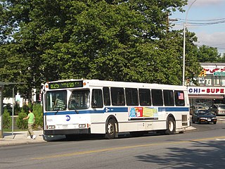
The Q25 and Q34 bus routes constitute a public transit line in Queens, New York City. The south-to-north route runs primarily on Parsons Boulevard and Kissena Boulevard, serving two major bus-subway hubs: Sutphin Boulevard–Archer Avenue–Jamaica and Flushing–Main Street. The Q25 terminates in College Point, and the Q34 in Whitestone, both in northern Queens.

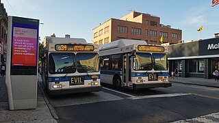
The Q20A and Q20B and Q44 bus routes constitute the Main Street Line, a public transit line in Queens, New York City, running primarily along Main Street between two major bus-subway hubs in the neighborhoods of Jamaica and Flushing. The Q20A/B terminates in College Point at the north end of Queens. The Q44 continues north into the borough of the Bronx, terminating in the West Farms neighborhood near the Bronx Zoo. The Q44 is one of two Queens bus routes to operate between the two boroughs.

