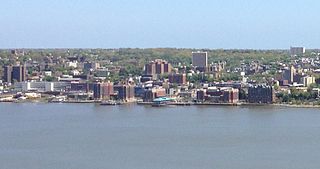
Yonkers is a city in Westchester County, New York, and a suburb of New York City. Developed along the Hudson River, it is the third most populous city, after New York City and Buffalo, and ninth most-populous municipality in the state of New York. The population of Yonkers was 211,569 as enumerated in the 2020 United States Census. It is classified as an inner suburb of New York City, located directly to the north of the Bronx and approximately 2.4 miles (4 km) north of Marble Hill, Manhattan, the northernmost point in Manhattan.

Woodlawn Heights, also known as Woodlawn, is a predominantly Irish-American working class neighborhood at the very north end of the borough of the Bronx in New York City. It is bounded by McLean Avenue to the north, the Bronx River to the east, Woodlawn Cemetery to the south, and Van Cortlandt Park to the west. Woodlawn Heights remains one of the few areas in New York City that still has young Irish immigrants still arriving to the area en masse.
Crestwood is a neighborhood in Yonkers, New York. Located in northeastern Yonkers, Crestwood is separated by the Bronx River from the village of Tuckahoe. Because the majority of Crestwood is served by the Tuckahoe post office, many residents identify their location as Tuckahoe or Crestwood, rather than Yonkers. Closer to the Crestwood train station, several grand homes occupy the hilly ground overlooking the river.
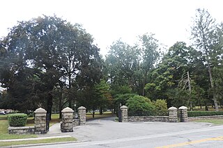
St. Joseph's Seminary and College, sometimes referred to as Dunwoodie after the Dunwoodie neighborhood of Yonkers, New York in which it is located, is the major seminary of the Archdiocese of New York. Its primary mission is to form men for the priesthood in the Catholic Church, whether in dioceses in the United States or abroad. The seminary also serves as the major seminary for the Community of the Franciscan Friars of the Renewal, who study alongside the diocesan seminarians, but live off campus at a friary in Yonkers.
Runyon Heights, also known as the area of Nepperhan, is a historically African American middle-class neighborhood in northwestern Yonkers, New York, US.

The Saw Mill River Parkway is a north–south parkway that extends for 28.93 miles (46.56 km) through Westchester County, New York, in the United States. It begins at the border between Westchester County and the Bronx, as the continuation of the Henry Hudson Parkway leaving New York City, and heads generally northeastward to an interchange with Interstate 684 (I-684). At its north end, the parkway serves as a collector/distributor road as it passes east of the hamlet of Katonah. The parkway is named for the Saw Mill River, which the highway parallels for most of its length.

Getty Square is the name for downtown Yonkers, New York, centered on the public square. Getty Square is the civic center, central business district, and transit hub of the City of Yonkers. A dense and growing residential area, it is located in southern Westchester County, New York. The square is named after prominent 19th-century merchant Robert Getty.

Interstate 95 (I-95) is part of the Interstate Highway System and runs from Miami, Florida, to the Canada–United States border near Houlton, Maine. In the US state of New York, I-95 extends 23.50 miles (37.82 km) from the George Washington Bridge in New York City to the Connecticut state line at Port Chester. The George Washington Bridge carries I-95 across the Hudson River from New Jersey into New York City. There, I-95 runs across Upper Manhattan on the Trans-Manhattan Expressway for 0.81 miles (1.30 km) through Washington Heights. It continues east across the Harlem River on the Alexander Hamilton Bridge and onto the Cross Bronx Expressway. In the Bronx, I-95 leaves the Cross Bronx at the Bruckner Interchange, joining the Bruckner Expressway to its end. North of the interchange with Pelham Parkway, it then continues northeast via the New England Thruway out of New York City into Westchester County and to the Connecticut state line, where I-95 continues on the Connecticut Turnpike.

Dyer Avenue is a short, north-south thoroughfare in the Hell's Kitchen neighborhood of Manhattan in New York City, located between Ninth Avenue and Tenth Avenue. It is primarily used by traffic exiting the Lincoln Tunnel. Dyer Avenue runs between 30th Street and 42nd Street but functions as three distinct sections due to its connections with the south and center tubes of the Lincoln Tunnel. The southernmost section, between 30th and 31st Streets, leads to and from the Lincoln Tunnel Expressway. Dyer Avenue also exists between 34th and 36th Streets, and between 40th and 42nd Streets; both sections lead directly from the tunnel, but the 34th-36th Streets section also contains a roadway leading to the tunnel. The avenue is owned by the Port Authority of New York and New Jersey.

Union Turnpike is a thoroughfare stretching across part of Long Island in southern New York state, mostly within central and eastern Queens in New York City. It runs from Myrtle Avenue in Glendale, Queens, to Marcus Avenue in North New Hyde Park, Nassau County, about 1 mile (1.6 km) outside New York City border. The name memorializes the Union Racetrack, once a famous attraction for Queens residents.
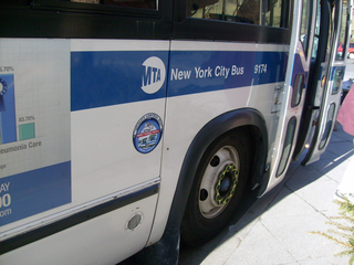
MTA Regional Bus Operations operates local and express buses serving New York City in the United States out of 29 bus depots. These depots are located in all five boroughs of the city, plus one located in nearby Yonkers in Westchester County. 21 of these depots serve MTA New York City Transit (NYCT)'s bus operations, while the remaining eight serve the MTA Bus Company These facilities perform regular maintenance, cleaning, and painting of buses, as well as collection of revenue from bus fareboxes. Several of these depots were once car barns for streetcars, while others were built much later and have only served buses. Employees of the depots are represented by local divisions of the Transport Workers Union of America (TWU), particularly the TWU Local 100 and 101, or of the Amalgamated Transit Union (ATU)'s Local's 726 for all depots in Staten Island, 1056 for Casey Stengel, Jamaica, and Queens Village Depots, and 1179 for JFK & Far Rockaway Depots.
The West Bronx is a region in the New York City borough of the Bronx. The region lies west of the Bronx River and roughly corresponds to the western half of the borough.

Audubon Avenue is an avenue in the Washington Heights neighborhood in Upper Manhattan that runs north-south, west of and parallel to Amsterdam Avenue. Its southern terminus is at West 165th Street and St. Nicholas Avenue, and its northern terminus is at Fort George Avenue, just north of West 193rd Street. It crosses over the Trans-Manhattan Expressway, east of the eastern portal of the expressway's tunnel.

Gun Hill Road is a major thoroughfare in the New York City borough of the Bronx. The road stretches for 3.5 miles (5.6 km) from Mosholu Parkway in Norwood to Stillwell Avenue in Baychester, near an exit for the Hutchinson River Parkway. Van Cortlandt Park and the Mosholu Golf Course are both located at the western terminus of Gun Hill Road.

Jerome Avenue is one of the longest thoroughfares in the New York City borough of the Bronx, New York, United States. The road is 5.6 miles (9.0 km) long and stretches from Concourse to Woodlawn. Both of these termini are with the Major Deegan Expressway which runs parallel to the west. Most of the elevated IRT Jerome Avenue Line runs along Jerome Avenue. The Cross Bronx Expressway interchanges with Jerome and the Deegan. Though it runs through what is now the West Bronx neighborhood, Jerome Avenue is the dividing avenue between nominal and some named "West" and "East" streets in the Bronx; Fifth Avenue, and to a lesser extent, Broadway, also splits Manhattan into nominal "West" and "East" streets.

Medfield is a neighborhood located in north Baltimore, Maryland, United States of America. It is located to the north of the trendy Hampden neighborhood and south of affluent Roland Park neighborhood. Its unofficial boundaries are Coldspring Lane to the north; Jones Falls Expressway to the west; Falls Road/Hickory Avenue to the east; and West 41st Street to the south.
St. Joseph Seminary can refer to:

Sedgwick Avenue is a major street in the Bronx, New York City. It runs roughly parallel to Jerome Avenue, the Major Deegan Expressway, and University Avenue. Sedgwick Avenue is one of the longest streets in the western part of the Bronx, running from Mosholu Parkway at the north to Macombs Dam Bridge at its southern end, about 800 feet west of Yankee Stadium.
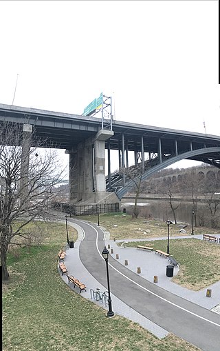
Bridge Park is a park in the Bronx, New York, created as part of a larger vision of creating connected waterfront parks along both sides of the Harlem River. The park's name references three large arch bridges linking Manhattan and the Bronx: Alexander Hamilton Bridge, Washington Bridge, and High Bridge.
