Related Research Articles
Yonkers is the third-most populous city in the U.S. state of New York and the most-populous city in Westchester County. A centrally located municipality within the New York metropolitan area, Yonkers had a population of 211,569 at the 2020 United States census. Yonkers is classified as an inner suburb of New York City, immediately north of the Bronx and approximately 2.4 miles (4 km) north of Marble Hill.

Bronxville is a village in Westchester County, New York, United States, located approximately 15 miles (24 km) north of Midtown Manhattan. It is part of the town of Eastchester. The village comprises one square mile (2.5 km2) of land in its entirety, approximately 20% of the town of Eastchester. As of the 2020 U.S. census, Bronxville had a population of 6,656. In 2016, Bronxville was rated by CNBC as the most expensive suburb of any of the U.S. ten largest cities, with a median home value of $2.33 million.
Crestwood is a neighborhood in Yonkers, New York. Located in northeastern Yonkers, Crestwood is separated by the Bronx River from the village of Tuckahoe. Because the majority of Crestwood is served by the Tuckahoe post office, many residents identify their location as Tuckahoe or Crestwood, rather than Yonkers. Closer to the Crestwood train station, several grand homes occupy the hilly ground overlooking the river.

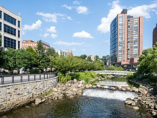
Bronx River Road is a major street and neighborhood in Yonkers, New York. It runs alongside the Bronx River, Bronx River Parkway, and Metro-North railroad tracks in south-eastern Yonkers. On the other side of the Bronx River is the City of Mount Vernon, New York as well as the Bronx. Bronx River Road runs down to McLean Avenue at the city line with New York City where it becomes Webster Avenue in the Woodlawn section of the Bronx. To the north, when it reaches the Cross County Parkway, Bronx River Road merges into Midland Avenue which leads to the Village of Bronxville, New York.
Runyon Heights, also known as the area of Nepperhan, is a historically African American middle-class neighborhood in northwestern Yonkers, New York, US.

Middle Village is a neighborhood in the central section of the borough of Queens, New York City, bounded to the north by the Long Island Expressway, to the east by Woodhaven Boulevard, to the south by Cooper Avenue and the former LIRR Montauk Branch railroad tracks, and to the west by Mount Olivet Cemetery. The small trapezoid-shaped area bounded by Mt. Olivet Crescent to the east, Fresh Pond Road to the west, Eliot Avenue to the north, and Metropolitan Avenue to the south is often counted as part of Middle Village, but is sometimes considered part of nearby Ridgewood.
North Riverdale is the northernmost part of the Riverdale neighborhood of the borough of the Bronx in New York City, particularly above 254th Street. It is a residential sub-neighborhood, and shares its northern border with Yonkers, New York in Westchester County.

Oak Forest is a large residential community in northwest Houston, Texas, United States. Oak Forest is the third largest group of subdivisions in Harris County.

Park Hill is a neighborhood in southwestern Yonkers, New York. The neighborhood is located atop a bluff east of South Broadway.
Slingerlands is a hamlet in the town of Bethlehem, Albany County, New York, United States. It is located immediately west of Delmar and near the New Scotland town-line and south of the Albany city-limits, and is thus a suburb of Albany. The Slingerlands ZIP Code (12159) includes parts of the towns of New Scotland and Guilderland.
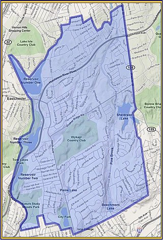
Wykagyl is a suburban community in New Rochelle, Westchester County, New York, United States. It is conterminous with ZIP code 10804, encompassing much of the city's 'North End'. According to Forbes, in 2010 Wykagyl's 10804 ZIP code, with a median home price of $806,264, ranked 333rd on its list of the 500 most expensive ZIP codes in the U.S. The Washington Post ranks Wykagyl among the nation's 650 Super Zips, or those with the highest percentile rankings for median household income and the share of adults with college degrees or higher.

Beverley Square East and Beverley Square West, also spelled Beverly Square, are a pair of neighborhoods in the Flatbush section of the New York City borough of Brooklyn. Located southwest of Prospect Park within what is now called Victorian Flatbush, one of the largest concentrations of Victorian houses in the United States, they were developed in the 1900s primarily by Thomas Benton Ackerson, whose former home is in Beverley Square West.

The Yonkers Public Library in Yonkers, New York, consists of three branch libraries. The main branch is the 'Yonkers Riverfront Library' which overlooks the Hudson River and New Jersey Palisades. Yonkers Riverfront Library is located in one of the former Otis Elevator buildings and it is across the street from the Yonkers train station. The new main library was opened in 2002, contains an area of 200,000 square feet (19,000 m2) and 4 stories.

Evergreen is a neighborhood in the North District of Baltimore, Maryland. Evergreen's buildings date from the late 19th to early 20th century. It is known as one of the first early non-rowhouse styled suburban communities in Baltimore.
Spann House is an historic Victorian-style building in Yonkers, New York.

The Church of St. John is a parish church under the authority of the Roman Catholic Archdiocese of New York, located at 3021 Kingsbridge Avenue, Bronx, New York City. Property was purchased in 1870 and construction of a wood-framed church was begun, this was the first Catholic church in Kingsbridge, Bronx.
The Yonkers Fire Department (YFD) provides fire protection and emergency medical services to the city of Yonkers, New York, United States.
Westchester Square is a residential neighborhood geographically located in the eastern section of the New York City borough of the Bronx. Its boundaries, starting from the north and moving clockwise are: East Tremont Avenue and Silver Street, Blondell Avenue and Westchester Creek to the east, Waterbury Avenue to the south and Castle Hill Avenue to the west. The main roadways through Westchester Square are East Tremont Avenue, Westchester Avenue and Williamsbridge Road.
There are numerous nationally and locally designated historic sites and attractions in Westchester County. These include architecturally significant manors and estates, churches, cemeteries, farmhouses, African-American heritage sites, and Underground Railroad depots and waystations. There are sites from pre-Revolutionary and Revolutionary times, as well as battlegrounds. Westchester County also played an important role in the development of the modern suburb, and there are many associated heritage sites and museums.

Cedar Knolls is a neighborhood of the city of Yonkers in New York's Westchester Countyknown for the neoclassical-style architecture of its houses, which give it a "frozen in time" look of an early-20th century town. It shares a zip code and postal address with the neighboring village of Bronxville, New York.
References
- ↑ "Our History". Archived from the original on 2013-10-08. Retrieved 2013-03-15.
- ↑ Vizard, Mary Mcaleer (26 February 1995). "If You're Thinking of Living In/Armour Villa; Bronxville, but Without Its High Taxes". The New York Times.
40°56′58″N73°49′54″W / 40.94944°N 73.83167°W
| | This article about a location in Westchester County, New York is a stub. You can help Wikipedia by expanding it. |