This article includes a list of references, related reading or external links, but its sources remain unclear because it lacks inline citations .(May 2009) (Learn how and when to remove this template message) |
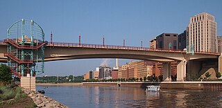
| Wilson Creek Bridge | |
|---|---|
Wilson Creek Bridge, looking northeast | |
| Coordinates | 37°10′26.004″N80°22′29.388″W / 37.17389000°N 80.37483000°W |
| Carries | Virginia Smart Road |
| Crosses | Wilson Creek, a tributary of the North Fork of the Roanoke River; County Route 723 (Ellett Road), part of U.S. Bicycle Route 76 and the TransAmerica Bicycle Trail |
| Locale | Montgomery County, Virginia |
| Maintained by | Virginia Tech Transportation Institute |
| Characteristics | |
| Design | Cast-in-place cantilever box girder |
| Total length | 1,985 feet (605 m) |
| Width | 40 feet (12 m), 2 lanes |
| Longest span | 472 feet (144 m) |
| Clearance below | 175 feet (53 m) |
| History | |
| Opened | May 30, 2001 |

The Wilson Creek Bridge (also known as the Smart Road Bridge) is the second tallest bridge in Virginia at 175 feet (53 m) tall, the tallest being the US-460 Corridor Q bridge over Grassy Creek and Virginia State Route 610 between Pike County and Buchanan County at 225 feet (69 m) tall. [1]

Virginia, officially the Commonwealth of Virginia, is a state in the Southeastern and Mid-Atlantic regions of the United States located between the Atlantic Coast and the Appalachian Mountains. The geography and climate of the Commonwealth are shaped by the Blue Ridge Mountains and the Chesapeake Bay, which provide habitat for much of its flora and fauna. The capital of the Commonwealth is Richmond; Virginia Beach is the most populous city, and Fairfax County is the most populous political subdivision. The Commonwealth's estimated population as of 2018 is over 8.5 million.
Corridor Q is a highway in the U.S. states of Kentucky, Virginia, and West Virginia. It is part of the Appalachian Development Highway System and U.S. Route 460. Corridor Q runs from Corridor B near Pikeville, Kentucky easterly to Interstate 81 in Christiansburg, Virginia.

Pike County is a county located in the U.S. state of Kentucky. As of the 2010 census, the population was 65,024. Its county seat is Pikeville. The county was founded in 1821.
Contents
The Wilson Creek Bridge is located in Montgomery County and was built as part of the Virginia Smart Road project. It is a cast-in-place cantilever box girder bridge and extends for 1,985 feet (605 m) with three spans of 472 feet (144 m) and two spans of 283 feet (86 m).

Montgomery County is a county located in the Valley and Ridge area of the U.S. state of Virginia. As population in the area increased, Montgomery County was formed in 1777 from Fincastle County, which in turn had been taken from Botetourt County. As of the 2010 census, the population was 94,392. Its county seat is Christiansburg.
The Virginia Smart Road, also known as simply the Smart Road or Smart Highway, is a short, limited access road in Montgomery County, Virginia, used for the testing of pavement technologies and as a proving ground for new transportation technologies. The Smart Road is currently a 2.2-mile (3.5 km) stretch of road with turn-around loops at either end. Eventually, the road will be extended to a total of 5.7 miles (9.2 km), which will directly connect U.S. Route 460 in Blacksburg to Interstate 81 with an interchange near mile marker 121; however, there is no set time frame for completion. The Wilson Creek Bridge was built for the Smart Road and, at 175 feet (53 m) tall, is the second tallest bridge in Virginia. The road and bridge are operated and maintained by the Virginia Department of Transportation. It is also part of the Proposed Interstate 73 Corridor.

A cantilever bridge is a bridge built using cantilevers, structures that project horizontally into space, supported on only one end. For small footbridges, the cantilevers may be simple beams; however, large cantilever bridges designed to handle road or rail traffic use trusses built from structural steel, or box girders built from prestressed concrete. The steel truss cantilever bridge was a major engineering breakthrough when first put into practice, as it can span distances of over 1,500 feet (460 m), and can be more easily constructed at difficult crossings by virtue of using little or no falsework.


