George P. Coleman Memorial Bridge

Last updated
Coleman Bridge
ColemanBridge.wmg.jpg
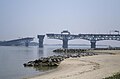
The Coleman Bridge as seen from Yorktown as it connects with Gloucester Point.
Coordinates 37°14′33″N76°30′25″W / 37.2426°N 76.5070°W / 37.2426; -76.5070 Coordinates: 37°14′33″N76°30′25″W / 37.2426°N 76.5070°W / 37.2426; -76.5070
Carries4 lanes of US 17.svg US 17
Crosses York River
Locale Gloucester Point and Yorktown, Virginia
Official nameGeorge P. Coleman Memorial Bridge
Maintained by Virginia Department of Transportation
ID number 000000000019824
Characteristics
Design Swing bridge, with two swinging spans
MaterialHigh-strength steel
Total length3,750 feet (1,140 m)
Longest span450 feet (140 m)
Clearance below 60 feet (18 m)
History
Designer Parsons Brinckerhoff
OpenedMay 7, 1952; rebuilt in spring 1995
Statistics
Daily traffic 33,595 (2005)
Toll$2.00 (northbound only) Smart Tag/E-ZPass
Location
George P. Coleman Memorial Bridge

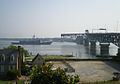
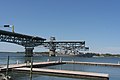
The George P. Coleman Memorial Bridge (known locally as simply the Coleman Bridge) is a double swing bridge that spans the York River between Yorktown and Gloucester Point, in the United States state of Virginia. It connects the Peninsula and Middle Peninsula regions of Tidewater, Virginia. The bridge is the only public crossing of the York River, though State Route 33 crosses both of its tributaries (the Mattaponi and Pamunkey Rivers) just upriver of their confluence at West Point.

Contents

History

Originally built in 1952, it was reconstructed and widened in 1995 through an unusual process which greatly reduced the time the important commuter artery was out-of-service from conventional methods. The current 3,750-foot (1,140 m)-long double-swing-span bridge carries United States Route 17, a four-lane arterial highway. The movable span is needed to allow ship access to several military installations that are upstream of the bridge, most notably, the United States Navy's Naval Weapons Station Yorktown. The roadways are almost 90 feet (27 m) above the river at the highest point of the bridge. The bridge is the largest double-swing-span bridge in the United States, and second largest in the world. [1] [2]

The toll bridge was named for George P. Coleman, who from 1913 to 1922 was the head of the Virginia Department of Highways and Transportation, predecessor to the Virginia Department of Transportation (VDOT). The bridge has been one of the sites of a special program to establish and encourage nesting locations for the peregrine falcon population of Virginia.

Toll rates

The George P. Coleman Memorial Bridge is a toll facility. Tolls are only collected northbound, and are used to pay for the expansion of the bridge to four lanes. Toll Collection Rates are as follows: [3]

Bicycles taking advantage of the free crossing must use the established bicycle lane located to the right of the far right travel lane. [4]

Photos

See also

Related Research Articles

<span class="mw-page-title-main">Interstate 66</span> Interstate in Virginia and DC

Interstate 66 (I-66) is an east–west Interstate Highway in the eastern United States. It runs from an interchange with I-81 near Middletown, Virginia, on its western end to an interchange with U.S. Route 29 (US 29) in Washington, D.C., at the eastern terminus. Much of the route parallels US 29 or State Route 55 (SR 55) in Virgina. I-66 has no physical or historical connection to the famous US 66, which was located in a different region of the United States.

E-ZPass is an electronic toll collection system used on toll roads, toll bridges, and toll tunnels in the Eastern United States, Midwestern United States, and Southern United States. The E-ZPass Interagency Group (IAG) consists of member agencies in several states, which use the same technology and allow travelers to use the same transponder on toll roads throughout the network. Since its creation in 1987, various independent systems that use the same technology have been folded into the E-ZPass system, including the I-PASS in Illinois and the NC Quick Pass in North Carolina. Negotiations are ongoing for nationwide interoperability in the United States.

<span class="mw-page-title-main">14th Street bridges</span> 3 bridges across the Potomac River connecting Arlington, VA and Washington, D.C., USA

The 14th Street bridges refers to the three bridges near each other that cross the Potomac River, connecting Arlington, Virginia and Washington, D.C. Sometimes the two nearby rail bridges are included as part of the 14th Street bridge complex. A major gateway for automotive, bicycle and rail traffic, the bridge complex is named for 14th Street, which feeds automotive traffic into it on the D.C. end.

<span class="mw-page-title-main">York River (Virginia)</span> River in Virginia, United States

The York River is a navigable estuary, approximately 34 miles (55 km) long, in eastern Virginia in the United States. It ranges in width from 1 mile (1.6 km) at its head to 2.5 miles (4.0 km) near its mouth on the west side of Chesapeake Bay. Its watershed drains an area of the coastal plain of Virginia north and east of Richmond.

<span class="mw-page-title-main">Governor Harry W. Nice Memorial Bridge</span> Bridge in Virginia and Newburg, Maryland

The Governor Harry W. Nice Memorial/Senator Thomas "Mac" Middleton Bridge, also known as the Potomac River Bridge, is a 1.7-mile (2.7 km), two-lane continuous truss bridge that spans the Potomac River between Newburg in Charles County, Maryland and Dahlgren in King George County, Virginia, United States. It is one of eight toll facilities operated by the Maryland Transportation Authority, and is one of two toll bridges over the Potomac River. The other, the privately owned Oldtown Low Water Toll Bridge, connects Maryland and West Virginia, far upstream. The new Nice Bridge opened to traffic in October 2022. The original bridge will likely be demolished; no traffic uses it since the new bridge opened.

<span class="mw-page-title-main">Hampton Roads Bridge–Tunnel</span> Bridge-tunnel connecting Virginia cities Norfolk and Hampton

The Hampton Roads Bridge–Tunnel (HRBT) is a 3.5-mile (5.6 km)-long Hampton Roads crossing for Interstate 64 and U.S. Route 60. It is a four-lane facility comprising bridges, trestles, man-made islands, and tunnels under the main shipping channels for Hampton Roads harbor in the southeastern portion of Virginia in the United States.

<span class="mw-page-title-main">James River Bridge</span> Bridge in VA to Newport News, VA

The James River Bridge (JRB) is a four-lane divided highway lift bridge across the James River in the Commonwealth of Virginia. Owned and operated by the Virginia Department of Transportation, it carries U.S. Route 17 (US 17), US 258, and State Route 32 across the river near its mouth at Hampton Roads. The bridge connects Newport News on the Virginia Peninsula with Isle of Wight County in the South Hampton Roads region, and is the easternmost such crossing without a tunnel component.

The Virginia Department of Transportation (VDOT) is the agency of the state government responsible for transportation in the state of Virginia in the United States. VDOT is headquartered at the Virginia Department of Highways Building in downtown Richmond. VDOT is responsible for building, maintaining, and operating the roads, bridges, and tunnels in the commonwealth. It is overseen by the Commonwealth Transportation Board, which has the power to fund airports, seaports, rail, and public transportation.

<span class="mw-page-title-main">Benjamin Harrison Memorial Bridge</span> Bridge in Jordans Point

The Benjamin Harrison Memorial Bridge is a vertical-lift bridge that spans the James River between Jordan's Point in Prince George County and Charles City County near Hopewell, Virginia. The bridge carries vehicle traffic of State Route 106 and State Route 156, and is owned by the Virginia Department of Transportation (VDOT). It is named after Benjamin Harrison V, a signer of the Declaration of Independence and a Governor of Virginia, who lived nearby at Berkeley Plantation.

<span class="mw-page-title-main">Colonial Parkway</span> Scenic parkway in Virginia

Colonial Parkway is a 23-mile (37 km) scenic parkway linking the three points of Virginia's Historic Triangle, Jamestown, Williamsburg, and Yorktown. It is part of the National Park Service's Colonial National Historical Park. Virginia's official state classification for the parkway is State Route 90003. With portions built between 1930 and 1957, it links the three communities via a roadway shielded from views of commercial development. The roadway is toll-free, is free of semi trucks, and has speed limits of around 35 to 45 mph. As a National Scenic Byway and All-American Road, it is also popular with tourists due to the James River and York River ends of the parkway.

<span class="mw-page-title-main">Broadway Bridge (Manhattan)</span> Bridge in Manhattan, New York

The Broadway Bridge is a vertical-lift bridge across the Harlem River Ship Canal in the borough of Manhattan in New York City. It connects the neighborhoods of Inwood on Manhattan Island and Marble Hill on the mainland. The bridge consists of two decks. The lower deck carries Broadway, which is designated as U.S. Route 9 at this location. The upper deck carries the New York City Subway's IRT Broadway–Seventh Avenue Line, serving the 1 train.

<span class="mw-page-title-main">Berkley Bridge (Virginia)</span> Bridge across Elizabeth River in Norfolk Virginia

The Interstate 264 Berkley Bridge is a double-leaf bascule bridge that crosses the Eastern Branch of the Elizabeth River in Norfolk, Virginia, United States. It carries Interstate 264 (I-264), U.S. Route 460 Alternate, and State Route 337 (SR 337) across the river, connecting the Berkley neighborhood south of the river with downtown Norfolk to the north. The toll-free facility is one of only a small number of movable bridges on the Interstate Highway System, and is the first of two in the Hampton Roads region, predating the High Rise Bridge. It is named for the former Town of Berkley that is now a part of the City of Norfolk.

<span class="mw-page-title-main">Downtown Tunnel</span> Tunnel across Southern Branch Elizabeth River in Virginia

The Downtown Tunnel on Interstate 264 (I-264) and U.S. Route 460 Alternate crosses the Southern Branch of the Elizabeth River in the South Hampton Roads area of Virginia, US. It links the independent City of Portsmouth with the independent City of Norfolk. In conjunction with the Berkley Bridge, the Downtown Tunnel connects to Interstate 464 to the City of Chesapeake and a continuation I-264 to the downtown and Waterside areas of Norfolk, and on to Virginia Beach. Owned by the Virginia Department of Transportation (VDOT), it is operated and maintained by Elizabeth River Crossings under a 58-year public–private partnership concession agreement. Formerly a toll-free facility, open road tolling was implemented on February 1, 2014 by VDOT to help finance repairs and expansion to the tunnel.

<span class="mw-page-title-main">American Legion Memorial Bridge (Potomac River)</span> Potomac River crossing between the states of Maryland and Virginia, United States

The American Legion Memorial Bridge, also known as the American Legion Bridge and formerly as the Cabin John Bridge, is a bridge carrying Interstate 495 across the Potomac River between Montgomery County, Maryland and Fairfax County, Virginia in the United States. It is an American Water Landmark. Plummers Island is located immediately downstream of the bridge.

<span class="mw-page-title-main">Crescent City Connection</span> Twin cantilever bridges over the Mississippi River in New Orleans, Louisiana, USA

The Crescent City Connection (CCC), formerly the Greater New Orleans Bridge (GNO), is a pair of cantilever bridges that carry U.S. Highway 90 Business over the Mississippi River in New Orleans, Louisiana, United States. They are tied as the fifth-longest cantilever bridges in the world. Each span carries four general-use automobile lanes; additionally the westbound span has two reversible HOV lanes across the river.

<span class="mw-page-title-main">Transportation in Virginia</span> Overview of land sea and air transport systems in Virginia

Transportation in the Commonwealth of Virginia is by land, sea and air. Virginia's extensive network of highways and railroads were developed and built over a period almost 400 years, beginning almost immediately after the founding of Jamestown in 1607, and often incorporating old established trails of the Native Americans.

<span class="mw-page-title-main">Interstate 64 in Virginia</span> Highway in Virginia

Interstate 64 (I-64) in the US state of Virginia runs east–west through the middle of the state from West Virginia to the Hampton Roads region, for a total of 299 miles (481 km). It is notable for crossing the mouth of the harbor of Hampton Roads on the Hampton Roads Bridge–Tunnel (HRBT), the first bridge–tunnel to incorporate artificial islands, concurrent with U.S. Route 60 (US 60). Also noteworthy is a section through Rockfish Gap, a wind gap in the Blue Ridge Mountains, which was equipped with an innovative system of airport-style runway lighting embedded into the pavement to aid motorists during periods of poor visibility due to fog or other conditions.

<span class="mw-page-title-main">Walt Whitman Bridge</span> Bridge between Philadelphia, PA and Gloucester City, NJ

The Walt Whitman Bridge is a single-level suspension bridge spanning the Delaware River from Philadelphia in the west to Gloucester City in Camden County, New Jersey in the east. The bridge is named after the poet Walt Whitman, who resided in nearby Camden toward the end of his life.

Virginia HOT lanes refers to six separate projects in the U.S. state of Virginia. The first project, completed in November 2012, added high-occupancy/toll (HO/T) lanes to the Capital Beltway (I-495) in Fairfax County. The second project, opened to the public in December 2014, involved converting and extending the existing reversible high-occupancy vehicle (HOV) lanes on I-95 and a portion of I-395 to HO/T lanes from Stafford to near Alexandria. The third project converted all lanes on I-66 inside the Beltway to peak-direction HO/T lanes, opening on December 4, 2017. The fourth project will reconstruct approximately 21 miles (34 km) of I-66 outside the Beltway, making it a 10-lane corridor. The fifth project, which was completed in November 2019, essentially extended the aforementioned I-95/I-395 project several miles to the north, converting the existing reversible HOV lanes on I-395 to HO/T lanes from near Alexandria to Washington, DC. The sixth project will convert the existing reversible HOV lanes to HO/T Lanes on Interstate 64 from Interstate 564 in Norfolk to Interstate 264 in Virginia Beach, and also propose to expand the I-64 express lanes before and after the HO/T Lanes.

References

  1. "BUILDING BIG: Databank: George P. Coleman Bridge". pbs.org.
  2. "George P. Coleman Bridge". roadstothefuture.com.
  3. "Hampton Roads Tunnels and Bridges". Virginia Department of Transportation. Retrieved 10 June 2019.
  4. "VDOT :: Coleman Bridge". ezpassva.com.