Transportation in Hampton Roads

Last updated
This view from space in July 1996 shows the majority of the Hampton Roads region which generally surround the harbor area of Hampton Roads, which framed by the Hampton Roads Bridge-Tunnel visible to the east (right), the Virginia Peninsula subregion to the north (top), and the Monitor-Merrimac Memorial Bridge-Tunnel to the west (left) and the 3 branches of the Elizabeth River which drain into the harbor from the south (bottom), running through many communities of the South Hampton Roads subregion. The Monitor-Merrimac Memorial Bridge Tunnel runs along a strip of I-664 to I-64 across the James River. To the west of the harbor, are the mouths of the James River (upper left) and the Nansemond River (lower left). Crossing the James River, the 4-mile (6 km)-long James River Bridge is also clearly visible, connecting Newport News with Isle of Wight County. NASA photograph Newport news norfolk portsmouth rotated.jpg
This view from space in July 1996 shows the majority of the Hampton Roads region which generally surround the harbor area of Hampton Roads, which framed by the Hampton Roads Bridge-Tunnel visible to the east (right), the Virginia Peninsula subregion to the north (top), and the Monitor-Merrimac Memorial Bridge-Tunnel to the west (left) and the 3 branches of the Elizabeth River which drain into the harbor from the south (bottom), running through many communities of the South Hampton Roads subregion. The Monitor-Merrimac Memorial Bridge Tunnel runs along a strip of I-664 to I-64 across the James River. To the west of the harbor, are the mouths of the James River (upper left) and the Nansemond River (lower left). Crossing the James River, the 4-mile (6 km)-long James River Bridge is also clearly visible, connecting Newport News with Isle of Wight County. NASA photograph

Historically, the harbor was the key to the Hampton Roads area's growth, both on land and in water-related activities and events. Ironically, the harbor and its tributary waterways were (and still are) both important transportation conduits and obstacles to other land-based commerce and travel. For hundreds of years, state and community leaders have worked to develop solutions to accommodate both.

Contents

Many early bridges were constructed and funded privately through the collection of tolls. Later, state-sponsorship was required to fund larger projects. The best example of many was in 1957, when the world's first continuous bridge-tunnel complex was successfully completed across the mouth of the Hampton Roads harbor, innovatively designed and funded with toll revenue bonds. Soon, another even larger one was built across the entire mouth of the Chesapeake Bay, exceeding many expectations.

In modern times, the region has faced increasing transportation challenges as it has become largely urbanized, with additional traffic needs. In the 21st century, the conflicts between traffic on vital waterways and land-based travel continue to present the area's leaders with extraordinary transportation challenges, both for additional capacity, and as the existing infrastructure, much of it originally built with toll revenues, has aged without an adequate source of funding to repair or build replacements. The now-closed Kings Highway Bridge in Suffolk and the Jordan Bridge in neighboring Chesapeake, each built in the 1920s, are considered locally prime examples of this situation.

Public opinion polls seem to indicate that many citizens feel the accomplishments with the historic bridge-tunnels across the harbor and nearby Chesapeake Bay and the many other improvements since, such as the completion of the Hampton Roads Beltway and a third bridge-tunnel (second across the harbor) in 1992 are indicative that the region's leaders will be capable of seeking and employing new transportation and funding solutions for the future, and that they will receive the necessary public support to do so.

In 2007, the new Hampton Roads Transportation Authority (HRTA) was formed under a controversial state law to levy various additional taxes to generate funding for major regional transportation projects, including a long-sought and costly so-called third crossing of the harbor of Hampton Roads. As of March 2008, although its projects were considered to be needed, the agency's future was in some question while its controversial sources of funding were being reconsidered in light of a Virginia Supreme Court decision. In the time since, a shift to facilities to be developed and maintained by public-private partnerships collecting tolls has come into greater focus. One such project, a replacement for the Jordan Bridge, is already under construction.

Highways, bridges, tunnels, bridge-tunnels, ferry system

I-64 on the Hampton Roads Beltway, north of I-264 I-64 sign, Hampton Roads.jpg
I-64 on the Hampton Roads Beltway, north of I-264

The Hampton Roads area has an extensive network of Interstate Highways, including the Interstate 64, the major east-west route to and from the area, and its spurs and bypasses of I-264, I-464, I-564, and I-664.

Long-term plans being pushed by the Raleigh-Durham area's Regional Transportation Alliance call for extension of I-495 northeastward to the Hampton Roads area. RTA's plan envisions the entirety of the corridor from Raleigh to Norfolk receiving a new two-digit interstate designation such as I-44. This interstate would connect two of the United States' largest metropolitan areas still lacking direct interstate access between each other. [1]

The Hampton Roads Beltway extends 56 miles (90 km) on a long loop through the region, crossing the harbor on two toll-free bridge-tunnel facilities. These crossings are the Hampton Roads Bridge-Tunnel between Phoebus in Hampton and Willoughby Spit in Norfolk and the Monitor-Merrimac Memorial Bridge-Tunnel between Newport News and Suffolk. The Beltway connects with another Interstate highway and three arterial U.S. Highways at Bower's Hill near the northeastern edge of the Great Dismal Swamp.

Other major east-west routes are U.S. Route 58, U.S. Route 60, and U.S. Route 460. The major north-south routes are U.S. Route 13 and U.S. Route 17.

Another major crossing of waterways is the James River Bridge, carrying US 17, US 258, and SR 32 from Newport News to Isle of Wight County.

There are also two other tunnels in the area, the Midtown Tunnel, and the Downtown Tunnel joining Portsmouth and Norfolk, as well as the 17-mile (27 km)-long Chesapeake Bay Bridge-Tunnel, a toll facility which links the region with Virginia's Eastern Shore which carries US 13. The original Downtown Tunnel in conjunction with the Berkley Bridge were considered a single bridge and tunnel complex when completed in 1952, perhaps stimulating the innovative bridge-tunnel design using man-made islands when the Hampton Roads Bridge-Tunnel was planned, first opening in 1957.

The George P. Coleman Memorial Bridge is a major toll bridge connecting U.S. Highway 17 on the Peninsula at Yorktown with Virginia's Middle Peninsula region.

Although earlier ferry services across the Bay, the harbor, and various rivers were eventually supplanted in the 20th century by bridges, tunnels, and bridge-tunnels, a passenger ferry continues to operate between Norfolk and Portsmouth, and one major automobile ferry service also remains. The Jamestown Ferry (also known as the Jamestown-Scotland Ferry) is an automobile ferry system on the James River connecting Jamestown in James City County with Scotland in Surry County. It carries State Route 31. Operated by VDOT, it is the only 24-hour state-run ferry operation in Virginia and has over 90 employees. It operates four ferryboats, the Pocahontas, the Williamsburg, the Surry, and the Virginia. The facility is toll-free.

Local public transportation

Map of Norfolk and Portsmouth Traction Company's Lines c 1907 Map of Norfolk and Portsmouth Traction Company's Lines c 1907.png
Map of Norfolk and Portsmouth Traction Company's Lines c 1907
Ferry Between Norfolk and Portsmouth PortsmouthNorfolkFerry1.jpg
Ferry Between Norfolk and Portsmouth

Local public transit is provided by a bus network operated by the Hampton Roads Transit (HRT) and Williamsburg Area Transit Authority (WATA), both of which are operations of government agencies. HRT's The Tide light rail system has completed construction and opened in early 2011.

In Virginia, the region is notable in that it has 2 types of public transport services via ferries. A passenger ferry is operated on the Elizabeth River between downtown areas of Norfolk and Portsmouth by HRT. A commuter bus route across the James River between Williamsburg and rural Surry County is provided via the vehicle-carrying Jamestown Ferry system.

Hampton Roads Transit

A regional transit bus system, paratransit service, and the Tide light rail system are provided by Hampton Roads Transit (HRT), a regional public transport system headquartered in Hampton. The HRT service area include the major population centers of Hampton Roads which are linked to each other by the Hampton Roads Beltway. Commuter service is provided through both major bridge-tunnels across the harbor helps reduce congestion in many other high traffic corridors. Many areas in adjoining communities are also served.

As the largest transit operator, Hampton Roads Transit is southeastern Virginia's most reliable mobility source, serving over 17 million annual passengers in the Hampton Roads metropolitan area. HRT currently serves 1.2 million people within its 369-square-mile (960 km2) service area.

Williamsburg Area Transit Authority

A line of WAT transit buses equipped with 2-way radios, wheelchair lifts and bike racks are seen ready for service at the Williamsburg Bus Facility on U.S. Route 60 in James City County, Virginia. WAT Buses at Williamsburg Bus Facility 2-03-2008.jpg
A line of WAT transit buses equipped with 2-way radios, wheelchair lifts and bike racks are seen ready for service at the Williamsburg Bus Facility on U.S. Route 60 in James City County, Virginia.
Williamsburg Transportation Center is an intermodal facility located in a restored Chesapeake and Ohio Railway station located within walking distance of Colonial Williamsburg's Historic Area, the College of William and Mary, and the downtown area. Williamsburg Transportation Center in Williamsburg Virginia 2-03-2008.jpg
Williamsburg Transportation Center is an intermodal facility located in a restored Chesapeake and Ohio Railway station located within walking distance of Colonial Williamsburg's Historic Area, the College of William and Mary, and the downtown area.

In the upper (western) Peninsula area known as the Historic Triangle, a transit bus system and paratransit services are provided by Williamsburg Area Transit Authority (WATA), based in the Williamsburg area, which serves Williamsburg, James City County, and a portion of York County. The system offers a connection with the much larger Hampton Roads Transit system at Lee Hall, Virginia and at the Williamsburg Transportation Center.

The Williamsburg Transportation Center is located in a restored building which was formerly a Chesapeake and Ohio Railway station. Along the railroad line built to connect the Ohio River Valley with the new city of Newport News and the port of Hampton Roads by Collis P. Huntington in 1881, the station was originally built in 1935 with funding from John D. Rockefeller Jr. as part of the restoration of the colonial capital which became known worldwide as Colonial Williamsburg. During the heyday of the railroads, dozens of dignitaries arrived there, including Presidents Franklin D. Roosevelt, Harry S. Truman and Dwight D. Eisenhower and Winston Churchill. In modern times, the center offers good non-automobile driving alternatives for visitors and citizens, both getting there, and moving around locally, with rail service, intercity and local transit bus services.

Light rail, bus rapid transit, maglev projects

A light rail service known as The Tide was opened in Norfolk on August 19, 2011 and extends 7.4 miles from the Eastern Virginia Medical Center complex east through downtown Norfolk and adjacent to I-264 to Newtown Road. Operated by Hampton Roads Transit, it is the first major light rail service in the state. As of April 17, 2012, the daily ridership was estimated to be 4,900. [2]

The Virginia Beach Transit Extension Study is examining the best transit options for possibly extending The Tide or adding bus rapid transit from Newtown Road to the Virginia Beach Oceanfront. [3]

There has also been a light rail study in the Hampton - Newport News areas.

There is a small very experimental Magnetic levitation project under development on campus at Old Dominion University in Norfolk. Using a new experimental technology, it was not yet operational as of 2011.

Intercity bus

Intercity bus service is provided by Greyhound Lines and Carolina Trailways.

Passenger rail

The area is served by passenger rail service provided by Amtrak, with stations in Williamsburg, Newport News, and Norfolk, and connecting bus service to Virginia Beach.

The Virginia Department of Rail and Public Transportation has studies underway for extending high speed passenger rail to the Virginia Peninsula and South Hampton Roads areas with a rail connection at Richmond to the Southeast High Speed Rail Corridor.

Air

The Hampton Roads is served by two major commercial airports: Norfolk International Airport and the smaller Newport News/Williamsburg International Airport. Alternatively, some travelers from the Peninsula and Williamsburg area also sometimes use Richmond International Airport, located 42 miles (68 km) west of Williamsburg and 8 miles (13 km) east of Richmond in Henrico County, Virginia.

Norfolk International Airport

Norfolk International Airport (ORF) is the main air passenger and cargo transport hub in the region. Offering nearly 160 arrivals and departures daily to major cities throughout the US, Norfolk International presently ranks in the country's top 65 airports in terms of passengers served annually, with an average of 3.5 million. The airport is served by five airlines, with flights to 25 nonstop destinations:

Newport News/Williamsburg International Airport

Newport News/Williamsburg International Airport (PHF) (formerly known as Patrick Henry Field) is a regional air passenger transport hub in southeastern Virginia. The airport, which is among the fastest growing airports in the country (by passenger volume), serves an average of 1.5 million annual passengers, and is served by four (4) airlines, with flights to twelve nonstop destinations. It is the hub for up-start low-cost carrier People Express Airlines, which takes its name from the famous 1970s airline of the same name. Destinations served include:

See also

Related Research Articles

<span class="mw-page-title-main">Newport News, Virginia</span> Independent city in Virginia, United States

Newport News is an independent city in the Commonwealth of Virginia in the United States. At the 2020 census, the population was 186,247. Located in the Hampton Roads region, it is the fifth-most populous city in Virginia and 140th-most populous city in the United States.

<span class="mw-page-title-main">Hampton, Virginia</span> Independent city in Virginia, United States

Hampton is an independent city in Virginia, United States. As of the 2020 census, the population was 137,148. It is the 7th-most populous city in Virginia and 204th-most populous city in the nation. Hampton is included in the Hampton Roads metropolitan area, the 37th-largest in the United States, with a total population of 1,799,674 in 2020. This area, known as "America's First Region", also includes the independent cities of Chesapeake, Virginia Beach, Newport News, Norfolk, Portsmouth, and Suffolk, as well as other smaller cities, counties, and towns of Hampton Roads.

<span class="mw-page-title-main">Hampton Roads</span> Body of water and metropolitan area in the U.S. states of Virginia and North Carolina

Hampton Roads is the name of both a body of water in the United States that serves as a wide channel for the James, Nansemond, and Elizabeth rivers between Old Point Comfort and Sewell's Point where the Chesapeake Bay flows into the Atlantic Ocean, and the surrounding metropolitan region located in the southeastern Virginia and northeastern North Carolina portions of the Tidewater Region.

<span class="mw-page-title-main">Norfolk International Airport</span> Airport in Norfolk, Virginia

Norfolk International Airport is seven miles (11 km) northeast of downtown Norfolk, an independent city in Virginia, United States. It is owned and operated by the Norfolk Airport Authority: a bureau under the municipal government. The airport serves the Hampton Roads metropolitan area of southeast Virginia as well as northeast North Carolina. Despite its name, the airport does not have any international destinations nonstop.

<span class="mw-page-title-main">Jamestown Ferry</span>

<span class="mw-page-title-main">Newport News/Williamsburg International Airport</span> Airport in Newport News, Virginia

Newport News/Williamsburg International Airport is in Newport News, Virginia, United States, and serves the Hampton Roads area along with Norfolk International Airport in Norfolk. The airport is owned and operated by the Peninsula Airport Commission, a political subdivision of the Commonwealth of Virginia. PHF covers 1,800 acres.

<span class="mw-page-title-main">Hampton Roads Transit</span>

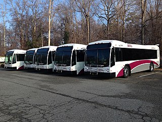
Hampton Roads Transit (HRT), incorporated on October 1, 1999, began through the voluntary merger of PENTRAN on the Virginia Peninsula and TRT in South Hampton Roads and currently serves over 22 million annual passengers within its 369-square-mile (960 km2) service area around Hampton Roads. The purpose of the HRT is to provide reliable and efficient transportation service and facilities to the Hampton Roads community. In 2022, the system had a ridership of 6,750,200, or about 25,500 per weekday as of the third quarter of 2023.

<span class="mw-page-title-main">Transportation in Virginia</span> Overview of land sea and air transport systems in Virginia

Transportation in the Commonwealth of Virginia is by land, sea and air. Virginia's extensive network of highways and railroads were developed and built over a period almost 400 years, beginning almost immediately after the founding of Jamestown in 1607, and often incorporating old established trails of the Native Americans.

<span class="mw-page-title-main">Transportation in Richmond, Virginia</span>

Transportation in Richmond, Virginia and its immediate surroundings include land, sea and air modes. This article includes the independent city and portions of the contiguous counties of Henrico and Chesterfield. While almost all of Henrico County would be considered part of the Richmond area, southern and eastern portions of Chesterfield adjoin the three smaller independent cities of Petersburg, Hopewell, and Colonial Heights, collectively commonly called the Tri-Cities area. A largely rural section of southwestern Chesterfield may be considered not a portion of either suburban area.

<span class="mw-page-title-main">Virginia State Route 168</span> State highway in Virginia, United States

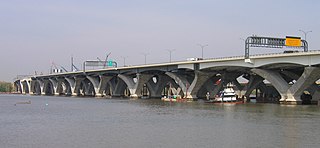
State Route 168 is a primary state highway in the South Hampton Roads region of the U.S. state of Virginia. It runs from the border with North Carolina through the independent cities of Chesapeake and Norfolk where it ends in the Ocean View area near the Hampton Roads Bridge-Tunnel.

<span class="mw-page-title-main">Williamsburg Area Transit Authority</span>

Williamsburg Area Transit Authority (WATA) is a multi-jurisdiction transportation agency providing transit bus and ADA Paratransit services in the City of Williamsburg, James City County, York County in the Historic Triangle area and Surry County, VA of the Virginia Peninsula subregion of Hampton Roads in southeastern Virginia.

<span class="mw-page-title-main">Williamsburg Transportation Center</span> Intermodal transportation hub in Williamsburg, Virginia

Williamsburg Transportation Center is an intermodal transit station in Williamsburg, Virginia. Operated by the Williamsburg Area Transit Authority, it also serves Amtrak's Northeast Regional train as well as Greyhound Lines and Hampton Roads Transit intercity buses. The transportation center was formerly a Chesapeake and Ohio Railway (C&O) passenger station.

<span class="mw-page-title-main">Newport News station</span> Railway station in Newport News, Virginia

Newport News station is an Amtrak intercity train station in Newport News, Virginia. The station is the southern terminus of two daily Northeast Regional round trips. It has a single side platform adjacent to a large CSX rail yard. An Amtrak Thruway motorcoach connection to Norfolk station effectively doubles the frequency between each station and Washington.

<span class="mw-page-title-main">The Tide (light rail network)</span>

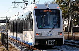
The Tide is a 7.4 mi (12 km) light rail line in Norfolk, Virginia, United States, owned and operated by Hampton Roads Transit (HRT). It connects Eastern Virginia Medical School, downtown Norfolk, Norfolk State University, and Newtown Road. Service began on August 19, 2011, making it the first light rail system in Virginia. Fares match local bus fares and the line accepts HRT's GO Passes. Trains generally run every 15 minutes, increasing to every 10 minutes during peak periods and every 30 minutes during early mornings and late evenings. In 2022, the system had a ridership of 732,700, or about 2,800 per weekday as of the third quarter of 2023.

Located in the southeastern corner of the state, Norfolk is economically and culturally important to Virginia. A variety of transportation modes have developed around the city's importance and somewhat unusual geography.

<span class="mw-page-title-main">Transportation on Long Island</span> Overview of transportation on Long Island

Nearly every major type of transportation serves Long Island, including three major airports, railroads and subways, and several major highways. The New York City Subway only serves the New York City boroughs of Brooklyn and Queens. There are historic and modern bridges, recreational and commuter trails, and ferries, that connect the boroughs of Queens and Brooklyn to Manhattan, the south shore with Fire Island and Long Island's north shore and east end with the state of Connecticut.

Virginia Beach, Virginia's development is tied to the establishment of a transportation infrastructure that allowed access to the Atlantic shoreline.

The city of Williamsburg, Virginia has a full range of transport facilities. Williamsburg is served by the Newport News/Williamsburg International Airport, and by two larger but more distant airports. The city is linked to several Interstate and State highways. A transport hub - the Williamsburg Transportation Center - serves bus and rail passengers. Motor traffic is restricted in the historic area, and the city as a whole is more "walkable" than the US norm. Cycling routes are also being provided.

<span class="mw-page-title-main">Transportation in New Jersey</span> Overview of the transportation in New Jersey

Transportation in New Jersey utilizes a combination of road, rail, air, and water modes. New Jersey is situated between Philadelphia and New York City, two major metropolitan centers of the Boston-Washington megalopolis, making it a regional corridor for transportation. As a result, New Jersey's freeways carry high volumes of interstate traffic and products. The main thoroughfare for long distance travel is the New Jersey Turnpike, the nation's fifth-busiest toll road. The Garden State Parkway connects the state's densely populated north to its southern shore region. New Jersey has the 4th smallest area of U.S. states, but its population density of 1,196 persons per sq. mi causes congestion to be a major issue for motorists.

<span class="mw-page-title-main">Transportation in Northern Virginia</span> Overview of transportation in Northern Virginia

The Northern Virginia region is served by numerous mediums of transit. Transportation in the region is overseen by the Northern Virginia Transportation Commission and the Northern Virginia Transportation Authority.

References

  1. "Interstate 495 to Rocky Mount—Future I-44 to Hampton Roads". Raleigh, NC: Regional Transportation Alliance. December 14, 2013. Retrieved February 16, 2014.
  2. "One Million Tide Rides", Hampton Roads Transit April 16, 2012
  3. "VA Beach Government, Virginia Beach Light Rail Study". Vbgov.com. Retrieved 2013-02-25.