
The Potomac River is a major river in the Mid-Atlantic region of the United States that flows from the Potomac Highlands in West Virginia to the Chesapeake Bay in Maryland. It is 405 miles (652 km) long, with a drainage area of 14,700 square miles (38,000 km2), and is the fourth-largest river along the East Coast of the United States. More than 6 million people live within its watershed.

Chesapeake is an independent city in Virginia, United States. At the 2020 census, the population was 249,422, making it the second-most populous city in Virginia, the tenth largest in the Mid-Atlantic, and the 90th-most populous city in the United States.

The Chesapeake & Delaware Canal is a 14-mile (22.5 km)-long, 450-foot (137.2 m)-wide and 35-foot (10.7 m)-deep ship canal that connects the Delaware River with the Chesapeake Bay in the states of Delaware and Maryland in the United States.

The Intracoastal Waterway (ICW) is a 3,000-mile (4,800 km) inland waterway along the Atlantic and Gulf of Mexico coasts of the United States, running from Massachusetts southward along the Atlantic Seaboard and around the southern tip of Florida, then following the Gulf Coast to Brownsville, Texas. Some sections of the waterway consist of natural inlets, saltwater rivers, bays, and sounds, while others are artificial canals. It provides a navigable route along its length without many of the hazards of travel on the open sea.

A swing bridge is a movable bridge that can be rotated horizontally around a vertical axis. It has as its primary structural support a vertical locating pin and support ring, usually at or near to its center of gravity, about which the swing span can then pivot horizontally as shown in the animated illustration to the right.
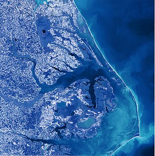
Albemarle Sound is a large estuary on the coast of North Carolina in the United States located at the confluence of a group of rivers, including the Chowan and Roanoke. It is separated from the Atlantic Ocean by the Currituck Banks, a barrier peninsula upon which the town of Kitty Hawk is located, at the eastern edge of the sound, and part of the greater Outer Banks region. Roanoke Island is situated at the southeastern corner of the sound, where it connects to Pamlico Sound. Much of the water in the Albemarle Sound is brackish or fresh, as opposed to the saltwater of the ocean, as a result of river water pouring into the sound.

Sabine Lake is a bay on the Gulf coasts of Texas and Louisiana, located approximately 90 miles (140 km) east of Houston and 160 miles (260 km) west of Baton Rouge, adjoining the city of Port Arthur. The lake is formed by the confluence of the Neches and Sabine Rivers and connects to the Gulf of Mexico through Sabine Pass. It forms part of the Texas–Louisiana border, falling within Jefferson and Orange Counties in Texas and Cameron Parish, Louisiana.

The Elizabeth River is a 6-mile-long (10 km) tidal estuary forming an arm of Hampton Roads harbor at the southern end of Chesapeake Bay in southeast Virginia in the United States. It is located along the southern side of the mouth of the James River, between the cities of Portsmouth, Norfolk, and Chesapeake. Forming the core of the Hampton Roads harbor, it is heavily supported by its tributaries which depend upon it.

The Great Dismal Swamp is a large swamp in the Coastal Plain Region of southeastern Virginia and northeastern North Carolina in the eastern United States, between Norfolk, Virginia, and Elizabeth City, North Carolina. It is located in parts of the southern Virginia independent cities of Chesapeake and Suffolk and northern North Carolina counties of Gates, Pasquotank, and Camden. Some estimates place the original size of the swamp at over one million acres (4,000 km2). As of 2022 the size of the Great Dismal Swamp is around 750 square miles.

The Great Dismal Swamp National Wildlife Refuge was created in 1974 to help protect and preserve a portion of the Great Dismal Swamp, a marshy region on the Coastal Plain of southeastern Virginia and northeastern North Carolina between Norfolk, Virginia, and Elizabeth City, North Carolina in the United States. It is located in parts of the independent cities of Chesapeake and Suffolk in Virginia, and the counties of Camden, Gates, and Pasquotank in North Carolina.
The Dismal Swamp Canal is a canal located along the eastern edge of the Great Dismal Swamp in Virginia and North Carolina in the United States. Opened in 1805, it is the oldest continually operating man-made canal in the United States. It is part of the Intracoastal Waterway.
Great Bridge may refer to:

State Route 168 is a primary state highway in the South Hampton Roads region of the U.S. state of Virginia. It runs from the border with North Carolina through the independent cities of Chesapeake and Norfolk where it ends in the Ocean View area near the Hampton Roads Bridge-Tunnel.

The Jordan Bridge, officially named the South Norfolk Jordan Bridge, is a tolled highway fixed bridge which carries State Route 337 over the Southern Branch Elizabeth River between the City of Portsmouth into the City of Chesapeake in South Hampton Roads, Virginia. The new crossing is an all-electronic toll facility that eliminated bridge lifts and height and weight restrictions and restored a vital river crossing for the Hampton Roads region.

Albemarle-Pamlico Peninsula is a large peninsula on the North Carolina coast, lying between the Albemarle Sound to the north and the Pamlico Sound to the south. The 5 counties of Dare, Hyde, Beaufort, Tyrrell, and Washington all lie wholly or partly on the peninsula.
Dominion Boulevard Steel Bridge was a double-leaf bascule, two-lane drawbridge which spanned the Southern Branch Elizabeth River in the City of Chesapeake in South Hampton Roads in southeastern Virginia. Built in 1962 and operated by the City of Chesapeake, it carried U.S. Route 17 (US 17) which is Dominion Boulevard. The corridor frequently acts as a bypass route for congested I-64 High Rise Bridge traffic.

Currituck Sound is a lagoon located in northeastern part of North Carolina and extreme southeastern Virginia.

The Great Loop is a system of waterways that encompasses the eastern portion of the United States and part of Canada. It is made up of both natural and man-made waterways, including the Atlantic and Gulf Intracoastal Waterways, the Great Lakes, the Erie Canal, and the Mississippi and Tennessee-Tombigbee Waterway. The entire loop stretches about 6,000 miles (9,700 km).
The Southern Branch Elizabeth River is a 14.5-mile-long (23.3 km), primarily tidal river in the U.S. state of Virginia. It flows from south to north through the city of Chesapeake and forms the boundary between the cities of Portsmouth and Chesapeake for its northernmost 3 miles (5 km). It is a tributary of the Elizabeth River, connecting to the harbor of Hampton Roads to the north. It is part of the Intracoastal Waterway of the Atlantic coast of the United States, connecting by it to the North Landing River, which flows into North Carolina.


