Remington, Virginia

Last updated

Remington, Virginia
Remington, Virginia - panoramio - Idawriter (1).jpg
Central Remington
Seal of Remington, Virginia.png
VAMap-doton-Remington.PNG
Location of Remington, Virginia
Coordinates: 38°32′8″N77°48′29″W / 38.53556°N 77.80806°W / 38.53556; -77.80806
CountryUnited States
State Virginia
County Fauquier
Area
[1]
  Total0.22 sq mi (0.57 km2)
  Land0.22 sq mi (0.57 km2)
  Water0.00 sq mi (0.00 km2)
Elevation
272 ft (83 m)
Population
 (2010)
  Total598
  Estimate 
(2019) [2]
658
  Density3,004.57/sq mi (1,159.28/km2)
Time zone UTC−5 (Eastern (EST))
  Summer (DST) UTC−4 (EDT)
ZIP code
22734
Area code 540
FIPS code 51-66512 [3]
GNIS feature ID1499948 [4]
Website www.remington-va.gov

Remington is a small incorporated town in Fauquier County, Virginia, United States. The population was 598 at the 2010 census. It is near the highways, U.S. Route 15, U.S. Route 17, U.S. Route 29, and Virginia State Route 28. Remington is less than a mile northeast of the Culpeper County line.

Contents

History

The Remington Historic District was listed on the National Register of Historic Places in 2005. [5]

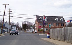
The town developed as a transportation hub. It was a commercial port during the mid-nineteenth century on the Rappahannock Canal, but the canal failed financially, and operations were abandoned. Later, the town was a stop on the Orange and Alexandria Railroad called Rappahannock Station, but the O&A was eventually absorbed into the Norfolk Southern system, and the Remington spur fell into disuse.

Remington was the site of the First Battle of Rappahannock Station and the Second Battle of Rappahannock Station during the American Civil War. The Battle of Brandy Station was fought just across the Rappahannock River. Colonel John S. Mosby made raids in the town during the war. Later, Mosby made his home and practiced law in nearby Warrenton, Virginia.

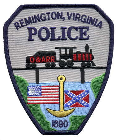
From 1985 to mid-2020, the town was among the last municipalities still using a Confederate battle flag in its official seal. [6] [7] A variation of the seal, Confederate flag included, appeared on their police uniform shoulder patches. [8] [9] The Remington town council voted to remove the Confederate flag from its seal on July 20, 2020. [10]

Geography

Remington is located at 38°32′8″N77°48′29″W / 38.53556°N 77.80806°W / 38.53556; -77.80806 (38.535464, 77.808117). [11]

According to the United States Census Bureau, the town has a total area of 0.2 square miles (0.6 km2), all of it land.

Demographics

Historical population
CensusPop.Note
1900 198
1910 25126.8%
1920 2676.4%
1930 2732.2%
1940 226−17.2%
1950 30936.7%
1960 288−6.8%
1970 32111.5%
1980 42532.4%
1990 4608.2%
2000 62435.7%
2010 598−4.2%
2019 (est.)658 [2] 10.0%
U.S. Decennial Census [12]

At the 2010 census there were 598 people, 238 households, and 163 families in the town. The population density was 2,876.4 people per square mile (1,095.1/km2). There were 255 housing units at an average density of 1,175.5 per square mile (447.5/km2). The racial makeup of the town was 74.41% White, 17.56% African American, 0.17% Native American, 0.67% Asian, 4.35% from other races, and 2.84% from two or more races. Hispanic or Latino of any race were 6.19%. [3]

Of the 238 households 36.1% had children under the age of 18 living with them, 41.6% were married couples living together, 19.3% had a female householder with no husband present, and 31.5% were non-families. 23.5% of households were one person and 7.1% were one person aged 65 or older. The average household size was 2.60 and the average family size was 3.02.

The age distribution was 27.9% under the age of 18, 10.3% from 18 to 24, 34.6% from 25 to 44, 20.4% from 45 to 64, and 6.9% 65 or older. The median age was 33 years. For every 100 females, there were 85.2 males. For every 100 females aged 18 and over, there were 87.5 males.

The median household income was $36,765 and the median family income was $37,969. Males had a median income of $31,250 versus $20,750 for females. The per capita income for the town was $16,693. About 11.0% of families and 13.6% of the population were below the poverty line, including 21.0% of those under age 18 and 12.5% of those age 65 or over.

View south along US 15 Bus/US 29 Bus in Remington 2018-10-10 18 18 13 View south along U.S. Route 15 Business and U.S. Route 29 Business (James Madison Street) just north of Main Street (Virginia State Route 651) in Remington, Fauquier County, Virginia.jpg
View south along US 15 Bus/US 29 Bus in Remington

Transportation

U.S. Route 15 and U.S. Route 29 are the main roadways to the Remington area. Direct access to downtown Remington is provided via U.S. Route 15 Business and U.S. Route 29 Business. Additional local roads provide access to adjacent unincorporated portions of Fauquier County.

Notable people

Related Research Articles

<span class="mw-page-title-main">Warren County, Virginia</span> County in Virginia, United States

Warren County is a U.S. county located in the Commonwealth of Virginia. The 2020 census places Warren County within the Washington-Arlington-Alexandria, DC-VA-MD-WV Metropolitan Statistical Area with a population of 40,727. The county was established in 1836. The county seat is Front Royal.

<span class="mw-page-title-main">Middlesex County, Virginia</span> County in Virginia, United States

Middlesex County is a county located on the Middle Peninsula in the U.S. state of Virginia. As of the 2020 census, the population was 10,625. Its county seat is Saluda.

<span class="mw-page-title-main">Manassas Park, Virginia</span> Independent city in Virginia, United States

Manassas Park is an independent city in the U.S. state of Virginia. As of the 2020 census, the population was 17,219. Manassas Park is bordered by the city of Manassas and Prince William County. Manassas Park is a part of the Washington-Arlington-Alexandria, DC-VA-MD-WV Metropolitan Statistical Area.

<span class="mw-page-title-main">Fauquier County, Virginia</span> County in Virginia, United States

Fauquier County is a county in the Commonwealth of Virginia. As of the 2020 census, the population was 72,972. The county seat is Warrenton.

<span class="mw-page-title-main">Essex County, Virginia</span> County in Virginia, United States

Essex County is a county located in the Middle Peninsula in the U.S. state of Virginia; the peninsula is bordered by the Rappahannock River on the north and King and Queen County on the south. As of the 2020 census, the population was 10,599. Its county seat is Tappahannock.

<span class="mw-page-title-main">Culpeper County, Virginia</span> County in Virginia, United States

Culpeper County is a county located along the borderlands of the northern and central region of the Commonwealth of Virginia. As of the 2020 United States Census, the population was 52,552. Its county seat and only incorporated community is Culpeper.

<span class="mw-page-title-main">Caroline County, Virginia</span> County in Virginia, United States

Caroline County is a United States county located in the eastern part of the Commonwealth of Virginia. The northern boundary of the county borders on the Rappahannock River, notably at the historic town of Port Royal. The Caroline county seat is Bowling Green.

<span class="mw-page-title-main">Siloam, Georgia</span> Town in Georgia, United States

Siloam is a town in Greene County, Georgia, United States. The population was 282 at the 2010 census, down from 331 in 2000.

<span class="mw-page-title-main">New Baden, Illinois</span> Village in Illinois, United States

New Baden is a village in Clinton County, Illinois, United States. The population was 3,428 at the 2020 census.

<span class="mw-page-title-main">Waterboro, Maine</span> Town in Maine, United States

Waterboro is a town in York County, Maine, United States. The population was 7,936 at the 2020 census. It is part of the Portland–South Portland–Biddeford, Maine metropolitan statistical area.

<span class="mw-page-title-main">Port Royal, Virginia</span> Town in Virginia, United States

Port Royal is an incorporated town in Caroline County, Virginia, United States. The population was 126 at the 2010 census.

<span class="mw-page-title-main">Tappahannock, Virginia</span> Town in Virginia, United States

Tappahannock is the oldest town in Essex County, Virginia, United States. The population was 2,375 at the 2010 census, up from 2,068 at the 2000 census. Located on the Rappahannock River, Tappahannock is the county seat of Essex County. Its name comes from an Algonquian language word lappihanne, meaning "Town on the rise and fall of water" or "where the tide ebbs and flows." The Rappahannock is a tidal estuary from above this point and downriver to its mouth on Chesapeake Bay.

<span class="mw-page-title-main">Centreville, Virginia</span> Census-designated Place in Virginia, United States

Centreville is a census-designated place (CDP) in Fairfax County, Virginia, United States. It is a suburb of Washington, D.C., the nation's capital. It had a population of 73,518, making it the most-populous community in Fairfax County as of the 2020 U.S. census

<span class="mw-page-title-main">The Plains, Virginia</span> Town in Virginia, United States

The Plains is a small incorporated town in Fauquier County, Virginia, United States. The population was 245 as of the 2020 census, up from 217 at the 2010 census. It is centered on the intersection of VA 55 and VA 245. The town of The Plains is situated off I-66. As of 2022, the mayor of The Plains is Lori Sisson.

<span class="mw-page-title-main">Warrenton, Virginia</span> Town in Virginia, United States

Warrenton is a town in Fauquier County, Virginia, of which it is the seat of government. The population was 10,057 as of the 2020 census, an increase from 9,611 at the 2010 census and 6,670 at the 2000 census. The estimated population in July 2021 was 10,109. It is at the junction of U.S. Route 15, U.S. Route 17, U.S. Route 29, and U.S. Route 211. The town is in the Piedmont region of Virginia just east of the Blue Ridge Mountains. The well-known Airlie Conference Center is 3 miles (5 km) north of Warrenton, and the historic Vint Hill Farms military facility is 9 miles (14 km) east. Fauquier Hospital is located in the town. Surrounded by Virginia wine and horse country, Warrenton is a popular destination outside Washington, D.C.

<span class="mw-page-title-main">Hamilton, Virginia</span> Town in Virginia

Hamilton is a town in the Loudoun Valley of Loudoun County, Virginia, United States. The population was 506 as of the 2010 census.

<span class="mw-page-title-main">Gainesville, Virginia</span> Census-designated place in Virginia, United States

Gainesville is a census-designated place (CDP) in western Prince William County, Virginia, United States. The population was 17,287 in the 2020 census.

<span class="mw-page-title-main">Nokesville, Virginia</span> Census-designated place in Virginia, United States

Nokesville is a Village and census-designated place (CDP) in Prince William County, Virginia, United States and Fauquier County, Virginia, United States. The population was 1,619 in the 2020 census.

<span class="mw-page-title-main">Falmouth, Virginia</span> Census-designated place in Virginia, United States

Falmouth is a census-designated place (CDP) in Stafford County, Virginia, United States. Situated on the north bank of the Rappahannock River at the falls, the community is north of and opposite the city of Fredericksburg. Recognized by the U.S. Census Bureau as a census-designated place (CDP), Falmouth's population was 4,956 as of the 2020 census.

<span class="mw-page-title-main">Summersville, West Virginia</span> City in West Virginia, United States

Summersville is a city in Nicholas County, West Virginia, United States. The population was 3,459 at the 2020 census. It is the county seat of Nicholas County.

References

  1. "2019 U.S. Gazetteer Files". United States Census Bureau. Retrieved August 7, 2020.
  2. 1 2 "Population and Housing Unit Estimates". United States Census Bureau. May 24, 2020. Retrieved May 27, 2020.
  3. 1 2 "U.S. Census website". United States Census Bureau . Retrieved January 31, 2008.
  4. "US Board on Geographic Names". United States Geological Survey. October 25, 2007. Retrieved January 31, 2008.
  5. "National Register Information System". National Register of Historic Places . National Park Service. July 9, 2010.
  6. "Town of Remington official website". Town of Remington official website. municipal govt., town of Remington. Archived from the original on March 9, 2020. Retrieved June 29, 2020.
  7. ""Welcome" slideshow image showing town emblem". Town of Remington official website. municipal govt., town of Remington. Archived from the original on July 5, 2020. Retrieved June 29, 2020.
  8. "About Us". RemingtonPolice.com. Remington Police Department. Archived from the original on January 21, 2020. Retrieved June 29, 2020.
  9. "image of police emblem patch". RemingtonPolice.com. Remington Police Department. Archived from the original on January 22, 2020. Retrieved June 29, 2020.
  10. ""Stars and bars" removed from Remington's seal".
  11. "US Gazetteer files: 2010, 2000, and 1990". United States Census Bureau. February 12, 2011. Retrieved April 23, 2011.
  12. "Census of Population and Housing". Census.gov. Retrieved June 4, 2015.