Berryville was founded at the intersection of the Winchester Turnpike and Charlestown Road. The land was first granted by the Crown to Captain Isaac Pennington in 1734, and George Washington surveyed it on October 23, 1750. In 1754, Pennington sold the land to Colonel John Hite.[7]
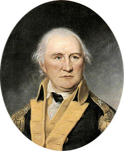
Early resident Col. Daniel Morgan
According to legend, Daniel Morgan would engage in combat with young toughs at the intersection, having first piled large stones nearby to use as ammunition in case of need.[8] Because of this story, and a rowdy tavern nearby, the area was first given the informal name of "Battle Town".
Hite sold the tract in 1765 to his son-in-law, Major Charles Smith. Smith named his estate "Battle Town", and on the site of the former tavern he built a clapboard homestead. This structure still stands on what is now Main Street and is now known as "The Nook".
Daniel Morgan returned to the area after distinguishing himself in the Revolution, living at Saratoga, and briefly at Soldier's Rest. He was one of the frequent (and reputedly most quarrelsome) patrons of the new tavern (where now stands the Battletown Inn).
Major Smith's son, John Smith, in 1797 sold 20 acres (81,000m2) of his inheritance to Benjamin Berry and Sarah (Berry) Stribling, who divided it into lots for a town. It was established as the town of Berryville on January 15, 1798.
By 1810, the town had at least 25 homes, three stores, an apothecary (pharmacy), two taverns, and an academy (school). It was not much larger when it was designated as the county seat of newly formed Clarke County in 1836.[9] An 1855 gazetteer described it as "a small town" that "has some trade, and contains an academy and 1 or 2 churches."[10]
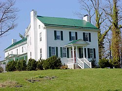
Virginia governor and U.S. senator Harry F. Byrd long resided in Berryville. A state senator in 1916, he built a log cabin named "Westwood" (a name he also gave his daughter) in Berryville at a family-owned orchard. The cabin was constructed from chestnut logs prior to the chestnut blight. In 1926, Byrd purchased Rosemont, an estate adjacent to his family's apple orchards in Berryville. He moved there with his family after his term as governor ended in 1929.[11]
As of the census[3] of 2000, there were 2,963 people, 1,239 households, and 783 families residing in the town. The population density was 1,648.3 people per square mile (635.6/km2). There were 1,312 housing units at an average density of 729.8 per square mile (281.4/km2). The racial makeup of the town was 84.54% White, 13.60% African American, 0.10% Native American, 0.57% Asian, 0.13% from other races, and 1.05% from two or more races. Hispanic or Latino of any race were 1.32% of the population.
There were 1,239 households, out of which 28.6% had children under the age of 18 living with them, 46.7% were married couples living together, 13.1% had a female householder with no husband present, and 36.8% were non-families. 32.8% of all households were made up of individuals, and 18.6% had someone living alone who was 65 years of age or older. The average household size was 2.28 and the average family size was 2.90.
In the town, the population was spread out, with 23.1% under the age of 18, 5.7% from 18 to 24, 27.3% from 25 to 44, 21.5% from 45 to 64, and 22.5% who were 65 years of age or older. The median age was 41 years. For every 100 females, there were 81.2 males. For every 100 females age 18 and over, there were 74.1 males.
The median income for a household in the town was $39,871, and the median income for a family was $52,176. Males had a median income of $38,750 versus $26,531 for females. The per capita income for the town was $20,337. About 4.1% of families and 7.0% of the population were below the poverty line, including 6.5% of those under age 18 and 16.3% of those age 65 or over.
US 340 in Berryville
Transportation
Berryville is located at the intersection of U.S. Route 340 and Virginia State Route 7. US 340 passes through the center of town, extending southwest to Front Royal and northeast to Charles Town. SR 7 bypasses the town just to the north, extending west to Winchester and east to Leesburg. US 340 also connects to Interstate 66 near Front Royal while SR 7 has a junction with Interstate 81 near Winchester. While SR 7 now bypasses downtown Berryville, SR 7 Business still passes through via Main Street.
Education
Berryville is home to D.G. Cooley Elementary School, Johnson Williams Middle School and Clarke County High School.
Climate
The climate in this area is characterized by hot, humid summers and generally mild to cool winters. According to the Köppen Climate Classification system, Berryville has a humid subtropical climate, abbreviated "Cfa" on climate maps.[14]
↑ Ronald L. Heinemann. "Harry F. Byrd (1887–1966)", Encyclopedia of Virginia. Ed. Brendan Wolfe. Virginia Foundation for the Humanities. First published February 12, 2008. Last modified April 7, 2011. Retrieved December 5, 2012.
This page is based on this Wikipedia article Text is available under the CC BY-SA 4.0 license; additional terms may apply. Images, videos and audio are available under their respective licenses.