Breaks, Virginia

Last updated

Breaks, Virginia
Breaks, Virginia.jpg
Breaks
USA Virginia location map.svg
Red pog.svg
Breaks
Usa edcp location map.svg
Red pog.svg
Breaks
Coordinates: 37°17′45″N82°16′52″W / 37.29583°N 82.28111°W
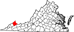
 / 37.29583; -82.28111
Country United States
State Virginia
Counties Buchanan
Dickenson
Elevation
1,476 ft (450 m)
Population
 (2020)
  Total144
Time zone UTC−5 (Eastern (EST))
  Summer (DST) UTC−4 (EDT)
FIPS code 51-09400
GNIS feature ID 1494190

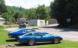
Breaks is a small unincorporated community and census-designated place (CDP) mostly in Buchanan County, Virginia, United States. [1] A small portion of the CDP is in Dickenson County. Breaks is located very close to the Kentucky border and is east of Breaks Interstate Park. Breaks gets its name in reference to the "break" in Pine Mountain, a mountain range that spans along the Kentucky-Virginia border and ends near the community of Breaks. [2] It was first listed as a CDP in the 2020 census with a population of 144. [3]

Contents

It was in Breaks that U.S. Senator George Allen called S. R. Sidarth, a volunteer for the Jim Webb campaign and an Indian American, a macaca. This started a controversy that gained national attention.[ citation needed ]

Demographics

Breaks has a population of 377 people who are all white with 64.1% who are married, 34% married with children and 18.9% have children but are single. [4]

Attractions

Related Research Articles

Grandwood Park is a census-designated place (CDP) in Warren Township, Lake County, Illinois, United States. Per the 2020 census, the population was 5,297.

<span class="mw-page-title-main">Hendron, Kentucky</span> Census-designated place in Kentucky, United States

Hendron is an unincorporated community and census-designated place (CDP) in McCracken County, Kentucky, United States. The population was 4,774 at the 2020 census. It is part of the Paducah, KY-IL Metropolitan Statistical Area.

Reidland is an unincorporated community and census-designated place (CDP) in McCracken County, Kentucky, United States. The population was 4,526 at the 2020 census. It is part of the Paducah, KY-IL Metropolitan Statistical Area.

<span class="mw-page-title-main">Elkhorn City, Kentucky</span> City in Kentucky, United States

Elkhorn City is a home rule-class city in Pike County, Kentucky, in the United States. The population was 1,035 at the 2020 census. The city is located in proximity to the Breaks Interstate Park.

<span class="mw-page-title-main">Haslett, Michigan</span> Census-designated place in Michigan, United States

Haslett is a census-designated place (CDP) in Ingham County in the U.S. state of Michigan. It is located mostly within Meridian Charter Township with a small portion extending east into Williamstown Township. The population was 19,220 at the 2010 census. Haslett contains its own school district, as well as its own post office with the 48840 ZIP Code.

<span class="mw-page-title-main">Annandale, Virginia</span> Census-designated place in Virginia, US

Annandale is a census-designated place (CDP) in Fairfax County, Virginia. The population of the CDP was 43,363 as of the 2020 United States Census. It is home to the oldest and largest branch of the Northern Virginia Community College system, and to one of the D.C. area's Koreatowns.

<span class="mw-page-title-main">Idylwood, Virginia</span> Census-designated place in Virginia, United States

Idylwood is a census-designated place (CDP) in Fairfax County, Virginia, United States. The population was 17,954 as of the 2020 census. It originally developed as a suburban community along the route of the Washington and Old Dominion Railroad, and later along Virginia State Route 7. The construction of the Capital Beltway in the 1960s, and I-66 and the Orange Line of the Washington Metrorail system in the 1980s, as well as the concurrent development of nearby Tysons Corner into Washington's leading suburban business district, led to the development of several apartment, townhouse, and small-lot single-family housing complexes, as well as the high-rise Idylwood Towers condominium, in the portion of Idylwood lying to the north of I-66. The area to the south of I-66 remains primarily large-lot single-family.

<span class="mw-page-title-main">Lincolnia, Virginia</span> Census-designated place in Virginia, United States

Lincolnia is a census-designated place (CDP) in Fairfax County, Virginia, United States. The population was 22,828 at the 2010 census, an increase of over 44% from 2000.

<span class="mw-page-title-main">Wolf Trap, Virginia</span> Census-designated place in Virginia, United States

Wolf Trap is a census-designated place (CDP) in Fairfax County, Virginia, United States. The population was 16,131 at the 2010 census. Wolf Trap National Park for the Performing Arts is located in the CDP.

<span class="mw-page-title-main">Ewing, Virginia</span> Census-designated place in Virginia, United States

Ewing is an unincorporated community and census-designated place (CDP) in Lee County, Virginia. The population was 439 at the 2010 U.S. Census. Ewing is one of the westernmost settlements in the Commonwealth of Virginia, before reaching the Cumberland Gap and the borders with Kentucky and Tennessee.

<span class="mw-page-title-main">Keokee, Virginia</span> Census-designated place in Virginia, United States

Keokee is an unincorporated community and census-designated place (CDP) in Lee County, Virginia, United States. The population was 416 at the 2010 census.

<span class="mw-page-title-main">Rose Hill, Lee County, Virginia</span> Census-designated place in Virginia, United States

Rose Hill is an unincorporated community and census-designated place (CDP) in Lee County, Virginia, United States. The population was 799 at the 2010 census, up from 714 at the 2000 census.

<span class="mw-page-title-main">Snoqualmie Pass, Washington</span> Census-designated place in Washington, United States

Snoqualmie Pass is a census-designated place (CDP) in Kittitas County, Washington, United States. It includes the unincorporated community of Hyak. The population was 311 at the 2010 census.

<span class="mw-page-title-main">Switzer, West Virginia</span> Census-designated place in West Virginia, United States

Switzer is an unincorporated community and census-designated place (CDP) in Logan County, West Virginia, United States. The CDP includes the neighboring unincorporated community of Micco. The total CDP population was 595 at the 2010 census.

<span class="mw-page-title-main">North Corbin, Kentucky</span> Census-designated place in Kentucky, United States

North Corbin is a census-designated place (CDP) in Laurel and Knox counties in the U.S. state of Kentucky. The population was 1,727 at the 2020 census down from 1,773 at the 2010 census. The census bureau also lists the Laurel County portion of North Corbin as a CCD with a population of 10,729.

<span class="mw-page-title-main">Tornado, West Virginia</span> Census-designated place in West Virginia, United States

Tornado, also called Upper Falls, is a census-designated place (CDP) in Kanawha County, West Virginia, United States.

<span class="mw-page-title-main">Cucumber, West Virginia</span> Census-designated place in West Virginia, United States

Cucumber is a census-designated place (CDP) in McDowell County, West Virginia, United States. Its population was 74 at the 2020 census. The community is centered on mining. Named either for nearby Cucumber Creek or for the cucumber trees in the area, it is the only community in the United States with this name. Its post office was still active as of October 2011.

<span class="mw-page-title-main">Fair Lakes, Virginia</span> Census-designated place in Virginia, United States

Fair Lakes is a census-designated place (CDP) and business park located west of Fairfax in Fairfax County, Virginia, United States. Fair Lakes had a population of 8,404 in 2020.

<span class="mw-page-title-main">McNair, Virginia</span> Census-designated place in Virginia, United States

McNair is a census-designated place located in the Oak Hill section of Fairfax County, Virginia, United States. It is directly to the east of Washington Dulles International Airport. The population as of the 2020 census was 21,598. Much of the population resides in the McNair Farms planned community. The community has a school called McNair Elementary.

<span class="mw-page-title-main">Belfry, Kentucky</span> Unincorporated community in Kentucky, United States

Belfry is an unincorporated community and census-designated place in Pike County, Kentucky. Belfry is located on U.S. Route 119, 16.8 miles (27.0 km) northeast of Pikeville. Belfry has a post office with ZIP code 41514, which opened on February 26, 1921. The origin of the name "Belfry" is obscure.

References

  1. U.S. Geological Survey Geographic Names Information System: Breaks
  2. Moyer, Armond; Moyer, Winifred (1958). The origins of unusual place-names. Keystone Pub. Associates. p. 16.
  3. "Breaks CDP, Virginia". United States Census Bureau . Retrieved April 7, 2022.
  4. "Bestplaces". Archived from the original on October 24, 2020.